| GISdevelopment.net ---> AARS ---> ACRS 1994 ---> Mapping from Space |
Achievements in Remote
Sensing Applications in India
MG Chandrasekhar, K Radhakrishana, V Jayaraman, B. Manikiam and H Honne Gowda
Indian Space Research Organization
Antariksh Bhawan, New BEL Road
Bangalore 560 094, India
MG Chandrasekhar, K Radhakrishana, V Jayaraman, B. Manikiam and H Honne Gowda
Indian Space Research Organization
Antariksh Bhawan, New BEL Road
Bangalore 560 094, India
Abstract
The remarkable developments in space technology during the last two decades have firmly established their immense potential for the optimum utilization of this technology for taking up many application project in various sectors of national development. The operation Indian remote Sensing Satellites, IRS-IA launched in March 1988 an dIRS IB launched in August 1991 are providing good quality data with a combined repetitivity of 11 days. The take off of a full fledged operation remote sensing programme, which only a few nations could achieve around the generation Indian Remote Sensing programme, which only few nations could achieve around the globe, is now well poised to reach even greater heights through the development of second generation Indian Remote Sensing Satellite series, name IRS-IC and IRS-ID with better capabilities. These satellites are scheduled for launch during 1995-98 timeframe. The IRS-P2 and IRS-P3 to be carried respectively on the developmental flights of PSLV during the time frame of 1994-96 are progressing well. Efforts are underway to realize an indigenously developed Ocean Satellite. Under the umbrella of National Natural Resources Management System (NNRMS), operationalisation of remote sensing in several new application areas was achieved with the active involvement of user agencies. IRS data is being used on an operational basis for several applications such as agriculture crop acreage and yield estimation, draught monitoring and assessment flood mapping, landuse and land cover mapping, wasteland management, urban planning, mineral prospecting, forest resources survey and management, soil mapping, water resources management, fisheries potential forecasting, coastal zone management environment impact assessment etc. a unique programme on integrated Mission of Sustainable Development aimed at generation of locale specific action plans for development at microlevel using integrated approach has been taken up covering one watershed/blocklevel using integrated approach has been taken up covering one in 7 districts have already been generated and they are being implemented. Further, Ministry of Rural Development has selected 92 blocks among the IMSD districts for implementation of Information system is progression satisfactorily. Department of Space (DOS) is providing adequate support for carrying out various national level projects. Facilities available at the state remote sensing centres and Central user departments also provide support for these projects. Towards human resources development, regular training programmes are being offered besides introduction of remote sensing in the curricula of many universities and institutions.
Introduction
The pressure of growing population, increased demand for food, fodder and fuelwood combined with rapid industrialization and urbanization have caused tremendous pressure on natural resources and environment. The consequent impact of these activities have given rise to crisis in agreoecosystems like land degradation, accelerated erosion, shifting cultivation, degradation of forests, increase in frequency of floods, pollution, urban sprawl etc. The challenge before us, therefore, is to reverse the process of degradation and undesirable changes in the environment in order to conserve and sustain the resource base of the country to meet the present demand as well as the future needs of the people.
In this context, the direct benefits from space technology and the applications driven approach adopted by the Indian Space Remote Sensing Programme have firmly established its immense potential to cater to the needs of national development. The evolution of National Natural Resource Management System (NNRMS) towards fully harnessing the potentials of space remote sensing and the development of the series of Indian Remote Sensing Satellites, besides establishment of necessary ground based data establishment of necessary ground based data reception processing and dissemination systems as well as remote sensing facilities at National Remote Sensing Agency (NRSA), Space Applications Centre (SAC) and Regional Remote Sensing (Service Centres (RRSSCs) for efficient and effective analysis of remotely sensed data are the major steps accomplished in pursuit of this goal. With the establishment of Remote Sensing Applications Centres in several States under many Governmental organizations, remote sensing today has come to stay as an integral part of the national development efforts in the vital sectors of agriculture, hydrology, geology, forestry, oceanography, mineral resources and distaster management like drought, flood, cyclone, earthquake, landslides crop pests, forest fires etc., thus touching every facet of national development. Today, India has acquired a strong self reliant base to harness the full potential of this technology and as a result, the national objective of achieving sustainable development at microlevel is being addressed through the integration of remotely sensed data with other relevant collateral information to arrive at locale specific, environment friendly, economically viable and culturally acceptable treatment packages (Rao, 1991 and Jayaramansn, el at 1993).
Space and Ground Segments
The Indian Remote Sensing Satellite (IRS-A), the first in the operational series of Indian Remote Sensing Satellites launched in March 1988, has been functioning satisfactorily for the past 6 ½ year but still continues tpo provide quality data. The second satellite in the IRS series, IRS-IB, launched in August 1991, is performing very well. These two satellites have become the mainstay of the National Natural Resources Management System (NNRMS) IRS-1A/1B provides imagery from the two cameras, linear Imaging Self Scanners, LISS-I with both the resolution 72.5m and LISS-IIA and LISS-IIB both with a resolution of 36.25m. IRS-1A and 1B together provide imagery with a combined repetivity of 11 days. While IRS-IA has so far provided more than 5,00,000 scenes, IRS-1B has provided more than 2,00,000 scenes. The successful implementation of the operational IRS-IA 1B system in the country and the need to cater tot eh enhanced user demands in the 1990's has given rise to configuring the second generation remote sensing satellitesm IRS-IC and ID taking in to account the technology development scenario and user requirements during the nineties.
Future Satellite Programmes
The second generation of IRS Satellites namely IRs-1C and 1D which are now under development for launch in 1995 and 1998 respectively have made very good progress during the year. These satellites will have better spectral and spatial resolutions, more frequent revisits, stereo-viewing and onboard data recording facility. The imaging sensors planned for IRS-IC and ID are a multi-spectral Linear Imaging Self Scanner (LISS-3) in visible and near Ir bands, a short Wave infrared (SWIR) band, a panchromatic camera with stereo viewing capability and a Wide Field Sensor (WIFS) in visible and near IR(Jayaraman et. al 1992). It is also planned to have onboard data recording capabilities to record the pay load data for wider data coverage/distribution. IRS-ID identical to IRS-IC will be in - orbit to ensure data continuity beyond the mid nineties. The development flights of PSLV during the timeframe of 1994-96 are progressing well. The IRS-P2 will carry the payload flown onboard IRS-IA and IB in order to provide continuity of data services to the remote sensing user community in the country. The IRS-P3 will carry a payload mix of sensors for application related to oceanography and vegetation dynamics. besides a scientific payload is planned to be included of experimental studies in X-ray astronomy. Thus IRS-P3 will carry a Modular Optoelectronic canner (MOS), a Wide field Sensor (WiFS) ad an X-ray astronomy payload.
Table 1 Orbital Characteristics of IRS-1C/1D
Table 2 Characteristics of IRS-1C/1D Payloads
The capability for microwave remote sensing has also been achieved in the India through development of airborne C-band SAR, multifrequency micro - wave radiometer and multifrequency scatterometer. Based on the encouraging results obtained from several pilot scale studies on ocean applications and considering the serious interest in monitoring and forecasting of a sea state from meteorological point of view, efforts are underway to realize and indigenously developed Oceansat.
Data Reception, Processing and Dissemination
The National Remote Sensing Agency (NRSA), Hyderabad continued to acquire and archive data from Indian Remote Sensing Satellites, IRS-IA and IRS-IB. In addition, data from other contemporary satellites, viz, Landsat NOAA and ERS-1 SAR are also being received. Augmention of ground segment elements for IRS-1C/1D data reception and processing is nearing completion. It is proposed to received SeaWiFS data after the launch SEASTAR satellite.
Satellite data products are being disseminated to the users in the form of photographic films, paper prints, CCT's floppy and cartridge products. About 705 of the user demands in the country is met by IRs-1A/1B data.
As part of aerial remote sensing programme, about 759 ours of aerial flying were undertake during the year mainly for aeromagnetic survey, town and country planning, sea level rise, oil exploration and metropolitan developments.
Remote Sensing Applications
With concerted efforts by Department of Space jointly with user departments, several applications, agriculture water, geology, forestry, oceanography and marine resources. Extensive organizational and institutional support services have been established with active involvement of use agencies both at Central State levels. The scenario of operation applications and the projections for immediate future application in the country is given in Figure 1.. Highlights of major operation application mission projects carried out in the country consists of :
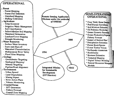
Figure 1 Remote Sensing Applications Scenerio in India
Sustainable development of natural resources relies on maintaining the fragile balance between productivity functions and conservation practices through precise identification and systematic monitoring of problem area in various resources and developmental sectors. It also calls for application of alternate agricultural practices, crop rotations use bio-fertilisers, energy-efficient farming methods and reclamation of under utilised and wastelands, planned exploitation of mineral and ground water resources etc. There fore optimal and exploitation of the resources (both renewable and non-renewable resources) calls for an holistic approach. The synoptic view provide by satellite remote sensing offers technologically the appropriate method for studying land and water resources, characterizing the coherent agricultural zones and identifying the constraints/ecological problems at microlevel. Effective use of space based remote sensing data suitably merged with collateral, socio economic and meteorological data through the use of geographic information system helps arriving at locale specific prescriptions to achieve sustainable development of natural resources of the region. The process of sustainable development packages evolving from such an integrated effort will be economically acceptable and environmentally friendly. Towards this, Department of space in 1988had initiated pilot studies in 21 perennially drought affected districts of the country to generate locale specific action plans. These pilot studies carried out has demonstrated the efficacy of using remote sensing based approach for optimal utilization of land and water resources towards combating drought on a long term basis.
Based on the results obtained form these pilot studies, Department of Space has launched a major, unique programme on Integrated Mission for Sustainable Development. This mission, as of now, covers a total of 157 problem districts of the country, covering nearly 45% of India's geographical area which are perennially affected and tribal areas.
The methodology of study involves generation of thematic maps showing current landuse/landcover, types of wasteland, forest cover/types, surface water resources. Drainage pattern, potential ground water zones, land forms (geomorphology, geology (rock types, structural features, mineral occurence0, soil types etc using data from Indian Remote Sensing Satellite. The map showing slope/aspect is prepared using topographic contour information and the meteorological data (rainfall intensity distribution etc0. are collected form existing database. The integration of the various thematic maps and attributes data, and further analysis for identified alternatives for development are carried out using geographic information system to identify set of coherent micro-level land units which are unique in terms of their resources potential and problems. Specific developmental plans for these units are arrived at in consultation with and close coordination between space scientists, experts from various central/state developmental departments, agricultural universities/research institutions, district level officials and local farmers, so as to ensure the technical feasibility and cultural acceptability of such action plans. Further, methodology has been developed to overlay the land capability map over the cadastral maps to provide information at the field levels. Various elements of such action plans are prioritized and categorised as those relating to land and water resources and others. Sensitivity of each element of the action plan would also be studied to see visible regress over the coming years, once they are implemented. The parameters such as, vegetation index, forest cover, land use, agricultural production, ground water table, soil erosion, etc., would be identified for bench marking the impact of such an implementation.
So far, action plans have been generated for one watershed each in 7 districts. The action plans are being implemented by the district authorities for these watersheds. The initial feedback on the implementation of action plans in the watersheds of Anantapur has been encouraging as shown by increased ground water levels through water harvesting structures and consequem agncumetna activities. The supports for implementation is derived from ongoing developmental programmes such as Drought Prone Area Development Programme (DPAP), Desert Development Programme (DDP), Integrated Wasteland Development Programme (IWDP), National Watersheds Development Project for Rain-fed Areas (NWDPRA), Hill Area Development Programme (HADP), etc. It is also proposed to use satellite data for monitoring of the impact of these action plans.
Further, in view of the advantages of the integrated approach wherein local specific action plans will be generated with cadastral overlays, Ministry of Rural Development has suggested taking up of 92 selected blocks from among the IMSD districts, on an urgent basis in a timeframe of 18 months. Ministry of Rural Development will provide funds for implementation of these action plans through pooling of resources from the various ongoing schemes for rural development.
National (Natural) Resources Information System (NRIS)
A National (Natural Resources Information System (NRIS) for the country has been evolved to aid decision makers at national/regiona/state/district/taluk levels. A numbe of pilot scale studies on various themes viz., wasteland development, land capability classes, district level planning, regional mineral targeting, etc., were carried out towards implementation of NRIS. Several geographic information packages have also been developed indigenously to cater to computer based decision support systems.
Infrastructure/Facilities Development
Fuller utilisation of this technology by uses has been ensured through establishing appropriate remote sensing facilities at central and state level user departments/agencies. As many as 22 States have established Remote Sensing Application Centres, which are carrying out several application projects of relevance to their region, besides participating in national level projects. They have established a strong interaction with all the concerned users. The DOS Centres such as NRSA, Hyderabad; SAC, Ahmedabad and RRSSCs located at Bangalore, Dehradun, Jodhpur, Kharagpur and Nagpur continued to execute various national level missions/projects, user projects, application validation projects, technology and software development activities and conduct of regular training programmes for users.
Training and Education in Remote Sensing
With the increased awareness and utilisation of remote sensing in India, need for adequate number of trained manpower for harnessing the benefits of remote sensing technology has steeply gone up. Adequate efforts are being made to increase the present throughput of trained manpower (of about 800) in various themes in collaboration with central/state/academic institution by way of augmenting the existing training infrastructure. Regular training courses are being conducted by several training institutions such as Indian Institute of Remote Sensing (IIRS, Dehradun), Centre of Studies for Resources Engineering (IIT, Bombay), Institute of Remote Sensing (Anna University, Madras), Survey of India, ecological Survey of India Training Institute, Forest Survey of India and Indian Agricultural Research Institute (IARI, Delhi). Besides these regular courses, on the job training is being provided by National Remote Sensing Agency (NRSA, Hyderabad) and Space Applications Centre (SAC, Ahmedabad) for specific themes and training in digital analysis and GIS by RRSSCs. So far as many as 6300 scientists have been trained in remote sensing. Efforts are also on to introduce remote sensing evening school and college curriculum. Many universities have introduced remote sensing in their post-graduate courses as a full-fledged degree course or a part of a core subject.
International Collaboration
India has many collaborative programmes with several countries in promoting active cooperation in remote sensing. For example, the ESCAP/UNDP Regional Remote Sensing Programme (RRSP), under the execution of the ESCAP, is playing a crucial rle in promoting active cooperation in remote sensing among member counties of Asia-Pacific region, by bringing together experts from different areas who can share their experiences, disseminating information on available expertise, disseminating information on available expertise, disseminating information on available experts where needed. The SHARES (Sharing of Experience) program initiated by India is also continuing to provide assistance to candidates from developing countries for participation in remote sensing training courses in India. The data reception/processing courses in India. The data reception/processing facility at Norman, USA has been recently established, to receive data from India Remote Sensing Satellite (IRS) as part of arrangements between EOSAT, USA and Department of Space/Antrix/NRSA, India, IRS-IC data is also planned to be acquired at this station once the satellite is launched. The DLR of Germany is providing a payload called Modular Opto-electronic Scanner (MOS) proposed to be flown in IRS-P3.
Conclusion
India was achieved a viable, self-reliant remote sensing programme with the establishment of expertise and self sufficiency in operationalisation of the Indian Remote Sensing Satellite series, establishment of a well kuit infrastructure for reception, processing, dissemination, analysis and interpretation of remote sensing data, operatonalisation of remote sensing data, operationalation of remote sensing applications in a wide range of resource sensing applications in a wide range of resource themes and developmental sectors and development of a resource information system using Geographic Information techniques. With the launching of a unique planning system of intergrated mission for sustainable development using space remote sensing inputs coupled with GIS to provide a holistic approach and to meet the growing demand of the increasing population, the remote sensing is pinsed to play a key role in the overall development of the nation. The availability of data from second generation satellites will further enhance the effectiveness of the mission for national development at microleved.
Acknowledgments
The authors acknowledge the valuable inputs provided by the NNRMS user community. Thanks are also due to Ms S vanaja for secretarial help and Ms M Sameena for cartography work.
References
The remarkable developments in space technology during the last two decades have firmly established their immense potential for the optimum utilization of this technology for taking up many application project in various sectors of national development. The operation Indian remote Sensing Satellites, IRS-IA launched in March 1988 an dIRS IB launched in August 1991 are providing good quality data with a combined repetitivity of 11 days. The take off of a full fledged operation remote sensing programme, which only a few nations could achieve around the generation Indian Remote Sensing programme, which only few nations could achieve around the globe, is now well poised to reach even greater heights through the development of second generation Indian Remote Sensing Satellite series, name IRS-IC and IRS-ID with better capabilities. These satellites are scheduled for launch during 1995-98 timeframe. The IRS-P2 and IRS-P3 to be carried respectively on the developmental flights of PSLV during the time frame of 1994-96 are progressing well. Efforts are underway to realize an indigenously developed Ocean Satellite. Under the umbrella of National Natural Resources Management System (NNRMS), operationalisation of remote sensing in several new application areas was achieved with the active involvement of user agencies. IRS data is being used on an operational basis for several applications such as agriculture crop acreage and yield estimation, draught monitoring and assessment flood mapping, landuse and land cover mapping, wasteland management, urban planning, mineral prospecting, forest resources survey and management, soil mapping, water resources management, fisheries potential forecasting, coastal zone management environment impact assessment etc. a unique programme on integrated Mission of Sustainable Development aimed at generation of locale specific action plans for development at microlevel using integrated approach has been taken up covering one watershed/blocklevel using integrated approach has been taken up covering one in 7 districts have already been generated and they are being implemented. Further, Ministry of Rural Development has selected 92 blocks among the IMSD districts for implementation of Information system is progression satisfactorily. Department of Space (DOS) is providing adequate support for carrying out various national level projects. Facilities available at the state remote sensing centres and Central user departments also provide support for these projects. Towards human resources development, regular training programmes are being offered besides introduction of remote sensing in the curricula of many universities and institutions.
Introduction
The pressure of growing population, increased demand for food, fodder and fuelwood combined with rapid industrialization and urbanization have caused tremendous pressure on natural resources and environment. The consequent impact of these activities have given rise to crisis in agreoecosystems like land degradation, accelerated erosion, shifting cultivation, degradation of forests, increase in frequency of floods, pollution, urban sprawl etc. The challenge before us, therefore, is to reverse the process of degradation and undesirable changes in the environment in order to conserve and sustain the resource base of the country to meet the present demand as well as the future needs of the people.
In this context, the direct benefits from space technology and the applications driven approach adopted by the Indian Space Remote Sensing Programme have firmly established its immense potential to cater to the needs of national development. The evolution of National Natural Resource Management System (NNRMS) towards fully harnessing the potentials of space remote sensing and the development of the series of Indian Remote Sensing Satellites, besides establishment of necessary ground based data establishment of necessary ground based data reception processing and dissemination systems as well as remote sensing facilities at National Remote Sensing Agency (NRSA), Space Applications Centre (SAC) and Regional Remote Sensing (Service Centres (RRSSCs) for efficient and effective analysis of remotely sensed data are the major steps accomplished in pursuit of this goal. With the establishment of Remote Sensing Applications Centres in several States under many Governmental organizations, remote sensing today has come to stay as an integral part of the national development efforts in the vital sectors of agriculture, hydrology, geology, forestry, oceanography, mineral resources and distaster management like drought, flood, cyclone, earthquake, landslides crop pests, forest fires etc., thus touching every facet of national development. Today, India has acquired a strong self reliant base to harness the full potential of this technology and as a result, the national objective of achieving sustainable development at microlevel is being addressed through the integration of remotely sensed data with other relevant collateral information to arrive at locale specific, environment friendly, economically viable and culturally acceptable treatment packages (Rao, 1991 and Jayaramansn, el at 1993).
Space and Ground Segments
The Indian Remote Sensing Satellite (IRS-A), the first in the operational series of Indian Remote Sensing Satellites launched in March 1988, has been functioning satisfactorily for the past 6 ½ year but still continues tpo provide quality data. The second satellite in the IRS series, IRS-IB, launched in August 1991, is performing very well. These two satellites have become the mainstay of the National Natural Resources Management System (NNRMS) IRS-1A/1B provides imagery from the two cameras, linear Imaging Self Scanners, LISS-I with both the resolution 72.5m and LISS-IIA and LISS-IIB both with a resolution of 36.25m. IRS-1A and 1B together provide imagery with a combined repetivity of 11 days. While IRS-IA has so far provided more than 5,00,000 scenes, IRS-1B has provided more than 2,00,000 scenes. The successful implementation of the operational IRS-IA 1B system in the country and the need to cater tot eh enhanced user demands in the 1990's has given rise to configuring the second generation remote sensing satellitesm IRS-IC and ID taking in to account the technology development scenario and user requirements during the nineties.
Future Satellite Programmes
The second generation of IRS Satellites namely IRs-1C and 1D which are now under development for launch in 1995 and 1998 respectively have made very good progress during the year. These satellites will have better spectral and spatial resolutions, more frequent revisits, stereo-viewing and onboard data recording facility. The imaging sensors planned for IRS-IC and ID are a multi-spectral Linear Imaging Self Scanner (LISS-3) in visible and near Ir bands, a short Wave infrared (SWIR) band, a panchromatic camera with stereo viewing capability and a Wide Field Sensor (WIFS) in visible and near IR(Jayaraman et. al 1992). It is also planned to have onboard data recording capabilities to record the pay load data for wider data coverage/distribution. IRS-ID identical to IRS-IC will be in - orbit to ensure data continuity beyond the mid nineties. The development flights of PSLV during the timeframe of 1994-96 are progressing well. The IRS-P2 will carry the payload flown onboard IRS-IA and IB in order to provide continuity of data services to the remote sensing user community in the country. The IRS-P3 will carry a payload mix of sensors for application related to oceanography and vegetation dynamics. besides a scientific payload is planned to be included of experimental studies in X-ray astronomy. Thus IRS-P3 will carry a Modular Optoelectronic canner (MOS), a Wide field Sensor (WiFS) ad an X-ray astronomy payload.
| Orbit | : | Polar sun-synchronous |
| Altitude | : | 817 km |
| Repetitivity | : | 24 days |
| Local time of Equator Crossing | : | 10.30 AM |
| Mission Life (planned) | : | 3 years |
| Characteristics | Payloads | ||
| Linear Imaging Self Scanning Sensor (LISS-3) | Wide Field Sensor (WiFS) | Panchromatic Camera (PAN) | |
| No. of Spectral Bands | 4 | 2 | 1 |
| Spectral Bands (microns) | B2 0.52 - 0.59 B3 0.62 - 0.68 B4 0.77 - 0.86 B5 1.55 - 1.70 |
B3 0.62 - 0.68 B4 0.77 - 0.86 |
0.50 - 0.75 |
| Spatial Resolution (m) | 23.5 for B2, B3, B4, and 70.5 for B5 | 188 | Better than 10m |
| Swath (Km) | 142 km | 774 | 70 km with steering Range +26° |
The capability for microwave remote sensing has also been achieved in the India through development of airborne C-band SAR, multifrequency micro - wave radiometer and multifrequency scatterometer. Based on the encouraging results obtained from several pilot scale studies on ocean applications and considering the serious interest in monitoring and forecasting of a sea state from meteorological point of view, efforts are underway to realize and indigenously developed Oceansat.
Data Reception, Processing and Dissemination
The National Remote Sensing Agency (NRSA), Hyderabad continued to acquire and archive data from Indian Remote Sensing Satellites, IRS-IA and IRS-IB. In addition, data from other contemporary satellites, viz, Landsat NOAA and ERS-1 SAR are also being received. Augmention of ground segment elements for IRS-1C/1D data reception and processing is nearing completion. It is proposed to received SeaWiFS data after the launch SEASTAR satellite.
Satellite data products are being disseminated to the users in the form of photographic films, paper prints, CCT's floppy and cartridge products. About 705 of the user demands in the country is met by IRs-1A/1B data.
As part of aerial remote sensing programme, about 759 ours of aerial flying were undertake during the year mainly for aeromagnetic survey, town and country planning, sea level rise, oil exploration and metropolitan developments.
Remote Sensing Applications
With concerted efforts by Department of Space jointly with user departments, several applications, agriculture water, geology, forestry, oceanography and marine resources. Extensive organizational and institutional support services have been established with active involvement of use agencies both at Central State levels. The scenario of operation applications and the projections for immediate future application in the country is given in Figure 1.. Highlights of major operation application mission projects carried out in the country consists of :
Figure 1 Remote Sensing Applications Scenerio in India
- Preharvest crop acreage and production estimates (CAPE) for wheat, rapeseed and mustard, Sorghum, rice, cotton and sunflower for large part of the country.
- Monitoring of seasonal drought conditions over the country based on satellite derived vegetation index.
- Near real time flood damage assessment in al the major flood prove river basins using optical and microwave data.
- Current landuse/landcover mapping for entire country towards agro-climatic zonal planning.
- Forest cover monitoring on a biennial basis to assess and detect changes
- Mapping of saline/alkaline soils for the entire country.
- Coastal landuse mapping for all maritime states of the country.
- Sea surface temperature (SST) retrieval and its applications including fisheries.
- Methodology development for retrieval of winds, waves, bathymetry, sea mounts, internal waves, ocean circulation etc., from ERS-1 microwave data.
- Applications of microwave SAR data for soil moisture assessment and crop identification.
- Geosphere Biospehre studies on carbon cycle in oceans, macro vegetation dynamics, forest biodiversity, forest eco dynamics etc.
Sustainable development of natural resources relies on maintaining the fragile balance between productivity functions and conservation practices through precise identification and systematic monitoring of problem area in various resources and developmental sectors. It also calls for application of alternate agricultural practices, crop rotations use bio-fertilisers, energy-efficient farming methods and reclamation of under utilised and wastelands, planned exploitation of mineral and ground water resources etc. There fore optimal and exploitation of the resources (both renewable and non-renewable resources) calls for an holistic approach. The synoptic view provide by satellite remote sensing offers technologically the appropriate method for studying land and water resources, characterizing the coherent agricultural zones and identifying the constraints/ecological problems at microlevel. Effective use of space based remote sensing data suitably merged with collateral, socio economic and meteorological data through the use of geographic information system helps arriving at locale specific prescriptions to achieve sustainable development of natural resources of the region. The process of sustainable development packages evolving from such an integrated effort will be economically acceptable and environmentally friendly. Towards this, Department of space in 1988had initiated pilot studies in 21 perennially drought affected districts of the country to generate locale specific action plans. These pilot studies carried out has demonstrated the efficacy of using remote sensing based approach for optimal utilization of land and water resources towards combating drought on a long term basis.
Based on the results obtained form these pilot studies, Department of Space has launched a major, unique programme on Integrated Mission for Sustainable Development. This mission, as of now, covers a total of 157 problem districts of the country, covering nearly 45% of India's geographical area which are perennially affected and tribal areas.
The methodology of study involves generation of thematic maps showing current landuse/landcover, types of wasteland, forest cover/types, surface water resources. Drainage pattern, potential ground water zones, land forms (geomorphology, geology (rock types, structural features, mineral occurence0, soil types etc using data from Indian Remote Sensing Satellite. The map showing slope/aspect is prepared using topographic contour information and the meteorological data (rainfall intensity distribution etc0. are collected form existing database. The integration of the various thematic maps and attributes data, and further analysis for identified alternatives for development are carried out using geographic information system to identify set of coherent micro-level land units which are unique in terms of their resources potential and problems. Specific developmental plans for these units are arrived at in consultation with and close coordination between space scientists, experts from various central/state developmental departments, agricultural universities/research institutions, district level officials and local farmers, so as to ensure the technical feasibility and cultural acceptability of such action plans. Further, methodology has been developed to overlay the land capability map over the cadastral maps to provide information at the field levels. Various elements of such action plans are prioritized and categorised as those relating to land and water resources and others. Sensitivity of each element of the action plan would also be studied to see visible regress over the coming years, once they are implemented. The parameters such as, vegetation index, forest cover, land use, agricultural production, ground water table, soil erosion, etc., would be identified for bench marking the impact of such an implementation.
So far, action plans have been generated for one watershed each in 7 districts. The action plans are being implemented by the district authorities for these watersheds. The initial feedback on the implementation of action plans in the watersheds of Anantapur has been encouraging as shown by increased ground water levels through water harvesting structures and consequem agncumetna activities. The supports for implementation is derived from ongoing developmental programmes such as Drought Prone Area Development Programme (DPAP), Desert Development Programme (DDP), Integrated Wasteland Development Programme (IWDP), National Watersheds Development Project for Rain-fed Areas (NWDPRA), Hill Area Development Programme (HADP), etc. It is also proposed to use satellite data for monitoring of the impact of these action plans.
Further, in view of the advantages of the integrated approach wherein local specific action plans will be generated with cadastral overlays, Ministry of Rural Development has suggested taking up of 92 selected blocks from among the IMSD districts, on an urgent basis in a timeframe of 18 months. Ministry of Rural Development will provide funds for implementation of these action plans through pooling of resources from the various ongoing schemes for rural development.
National (Natural) Resources Information System (NRIS)
A National (Natural Resources Information System (NRIS) for the country has been evolved to aid decision makers at national/regiona/state/district/taluk levels. A numbe of pilot scale studies on various themes viz., wasteland development, land capability classes, district level planning, regional mineral targeting, etc., were carried out towards implementation of NRIS. Several geographic information packages have also been developed indigenously to cater to computer based decision support systems.
Infrastructure/Facilities Development
Fuller utilisation of this technology by uses has been ensured through establishing appropriate remote sensing facilities at central and state level user departments/agencies. As many as 22 States have established Remote Sensing Application Centres, which are carrying out several application projects of relevance to their region, besides participating in national level projects. They have established a strong interaction with all the concerned users. The DOS Centres such as NRSA, Hyderabad; SAC, Ahmedabad and RRSSCs located at Bangalore, Dehradun, Jodhpur, Kharagpur and Nagpur continued to execute various national level missions/projects, user projects, application validation projects, technology and software development activities and conduct of regular training programmes for users.
Training and Education in Remote Sensing
With the increased awareness and utilisation of remote sensing in India, need for adequate number of trained manpower for harnessing the benefits of remote sensing technology has steeply gone up. Adequate efforts are being made to increase the present throughput of trained manpower (of about 800) in various themes in collaboration with central/state/academic institution by way of augmenting the existing training infrastructure. Regular training courses are being conducted by several training institutions such as Indian Institute of Remote Sensing (IIRS, Dehradun), Centre of Studies for Resources Engineering (IIT, Bombay), Institute of Remote Sensing (Anna University, Madras), Survey of India, ecological Survey of India Training Institute, Forest Survey of India and Indian Agricultural Research Institute (IARI, Delhi). Besides these regular courses, on the job training is being provided by National Remote Sensing Agency (NRSA, Hyderabad) and Space Applications Centre (SAC, Ahmedabad) for specific themes and training in digital analysis and GIS by RRSSCs. So far as many as 6300 scientists have been trained in remote sensing. Efforts are also on to introduce remote sensing evening school and college curriculum. Many universities have introduced remote sensing in their post-graduate courses as a full-fledged degree course or a part of a core subject.
International Collaboration
India has many collaborative programmes with several countries in promoting active cooperation in remote sensing. For example, the ESCAP/UNDP Regional Remote Sensing Programme (RRSP), under the execution of the ESCAP, is playing a crucial rle in promoting active cooperation in remote sensing among member counties of Asia-Pacific region, by bringing together experts from different areas who can share their experiences, disseminating information on available expertise, disseminating information on available expertise, disseminating information on available experts where needed. The SHARES (Sharing of Experience) program initiated by India is also continuing to provide assistance to candidates from developing countries for participation in remote sensing training courses in India. The data reception/processing courses in India. The data reception/processing facility at Norman, USA has been recently established, to receive data from India Remote Sensing Satellite (IRS) as part of arrangements between EOSAT, USA and Department of Space/Antrix/NRSA, India, IRS-IC data is also planned to be acquired at this station once the satellite is launched. The DLR of Germany is providing a payload called Modular Opto-electronic Scanner (MOS) proposed to be flown in IRS-P3.
Conclusion
India was achieved a viable, self-reliant remote sensing programme with the establishment of expertise and self sufficiency in operationalisation of the Indian Remote Sensing Satellite series, establishment of a well kuit infrastructure for reception, processing, dissemination, analysis and interpretation of remote sensing data, operatonalisation of remote sensing data, operationalation of remote sensing applications in a wide range of resource sensing applications in a wide range of resource themes and developmental sectors and development of a resource information system using Geographic Information techniques. With the launching of a unique planning system of intergrated mission for sustainable development using space remote sensing inputs coupled with GIS to provide a holistic approach and to meet the growing demand of the increasing population, the remote sensing is pinsed to play a key role in the overall development of the nation. The availability of data from second generation satellites will further enhance the effectiveness of the mission for national development at microleved.
Acknowledgments
The authors acknowledge the valuable inputs provided by the NNRMS user community. Thanks are also due to Ms S vanaja for secretarial help and Ms M Sameena for cartography work.
References
- Rao, U.R., 1991. Remote Sensing for National Development, Current Science, 61 (3&4): 121-128.
- Jayaraman, V., and Chandrasekhar, M.G., 1992. Second Generation Indian Remote Sensing Satellites - IRS-IC &ID, Presented at 43rd Congress of the IAF, Aug. 28-Sep. 5. 1992, Washington. D.C.
- Jayaraman, V., Chandrasekhar, M.G., and Rao, U.R., 1993. Remote Sensing for National Development : Implementing results achieved is th4 National Indian Satellite Programme. Presented at the UN/IAF Workshop on "Organising Space Activities in Developing Countries: Resources and Mechanics on 16/3/193 during 44th IAF Congress at Graz, Austria.
- Annual Report, 1993-94, Department of Space, Government of India, pp. 1-99.