| GISdevelopment.net ---> AARS ---> ACRS 1994 ---> Forestry |
Forest Mapping with NOAA
AVHRR Data Case Study: Effect of Thermal Band for Refiing Forest
Mapping
Mr Surat Lertlum, Prof. Shunji Murai
Computer Science Program
School of Advance Technology
Asian Institute of Technology
G.P.O. Box 2754, Bangkok 10501, Thailand
E-mail : surat.lertlum@cs.ait.ac.th, smu@cs.ait.ac.th
Mr Surat Lertlum, Prof. Shunji Murai
Computer Science Program
School of Advance Technology
Asian Institute of Technology
G.P.O. Box 2754, Bangkok 10501, Thailand
E-mail : surat.lertlum@cs.ait.ac.th, smu@cs.ait.ac.th
Abstract
In order to monitor forest area in such a wide area as Southeast Asia Peninsula, high resolution data set cannot easily be used for such a task because of the high volume of the data. Low resolution data such as NOAA AVHRR data set is a solution to such a task. A forest classification technique by using band 1, 2 3, and 4 of NOAA AVHRR including thermal bands is proposed in this study for more prices tropical forest classification, The accuracy was checked with the referenced forest map produced in 1991 by Royal Forest Department (RED) in Thailand, which showed only 1.17 percent discrepancy
1. Introduction
This research study tries to utilize low resolution data (cloud free mosaic of NOAA AVHRR LAC 1.1 km resolution) to monitor forest change in regional level for the purpose of management and planning The advantages of the use of low resolution satellite data (NOAA AVHRR) data are :
The advantages of the use of low resolution satellite data (NOAA AVHRR) data are :
This relatively cloud free AVHARR mosaic, which is the primary product of grid Bagkok is used as the tested data, The mosaic covers an area extending from East 81 degree to East 120 degree, and from North 29 degree to South 10 degree. The mosaic is composted from 38 selected daily AVHRR images recorded by NOAA -11 (afternoon pas) along 10 different orbits between 12 November 1990 and 2 March 1991.
The AVHRR HRPT Level 1b data were received by the Thailand Meteorological Department receiving station on a daily basis. Each 4-band image was geo-referenced by GRID-Bangkok at 1.1 kilometer resolution (actually 1/100 oa degree) into a Plate Carrie Projection
The geometric accuracy of about 1 pixel is reached using a two step rectification algorithm (orbital model and transformation by ground control points) The cloud screening algorithm uses NDVI and the band 4 to composite the daily images. No radiometric calibration or atmospheric correction is done (grid Bangkok 1992).
3. Methodology for Forest Classification
3.1 The reference data : Forest map by RFD (1991)
The reference data (Thailand's forest area 1991) came from the interpretation of Lansat 5 data in the scale of 1:250,000 took in 1991 Jarsput 1993 Thailand has forest area left about 136698 sq. Km or 26.64 percent of the area of the whole cournty
3.2 Expected result from this stage
At this stage forest map with 2 classified classed (forest non-forest) should be able to obtain. By first, the result forest/non forest map of Thailand classified by proposed method should be compared to the referenced forest map (1991) from the Royal Forest Department to check for the accuracy of the proposed calssification method. Then forest/non forest map of the whole study area including Thailand, Myanmar, Laos, Cambodia and vetnam area is generated.
3.3 Classification with low resolutin data
Until now, the research study has been done on multi-spectral analysis with not only Isabelle and infrared bands but also thermal bands by using mainly IDRISI software for analysis task (please see Figure 1 for forest classification framework). But the multi-resolution framework is already planned, and it will be studies d net to improve the result.
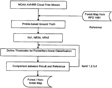
Figure 1 Forest classification framework with multispectral data sets
3.3.1. Trend study
In order to study the relationship between each parameter that may be used for the forest classification, trend study has been preformed on tested data by
Step 1 Profile checking between clearly classified forest and non-forest area to identify any relationships between tested parameters and the characteristic of forest area. (please see Figure 2 for the graph of the selected profiles)
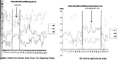
Figure 2 Sample selected profiles across (a) clearly forest/non-forest area (Kao Yai National Park) and (b) active agriculture area (Central Plain)
This procedure is consisted of the following :
This procedure is consisted of the following :
This procedure is consisted of the following:
1 NDVI (NVI) (Normalized Difference Vegetation Index)=
(band2-band1)/(band 2 +band1)
2 NR 34 (Normalized Difference index between band 3 and band 4) = (band3-band4)= / (band 3 + band4)
3 NR42 (Normalized Difference Index between band 4 and band 2) = (nand4-band2)/(band4+band2)
3.3.2 NDVI and other normalized difference indices for forest classification
The following three steps with specific thresholds were defined with six xelected profiles over well known forest and agricultural lands in Thailand for example Kao Yai National Park and Central Plain.
Step 1: Define threshold value of NDVI for dense vegetation (NDVI > 0.30 will be defined as forest and dense agriculture)
The normalized difference vegetation index (NDVI) is one such ratio which has been shown to be highly correlated with vegetation parameters biomass and green leaf area and hence is of considerable, value for vegetation discrimination (Curran 1980) . But one of the draw back of NDVI is that a cannot clearly distinguish between forest and dense agriculture area since it only detect the chlorophyll reflectance.
The additional information of the finding are :
Since we can not use NDVI only to classify forest land. from the experiment and analysis, normalized difference index between band 3 and band 4 can assist in the classification of the forest land because normalized difference e index between band 3 and band 4 can identify clear boundary of forest if we select appropriate threshold. The reason for the assumption came from the fact the value of band 4 (thermal band ) from forest land is less than its surrounding while the value of band 3 of forest land still high (please see graph of profile vector across forest area in Figure 2a) so the normalized difference index between band 3 and band 4 will able to assist in denitrifying forest land. From the examination, the value of greater than or equal to 0.19 of such an index can be used to assist in identifying forest boundary.
The additional information of the finding are :
From the study, we also found out that normalized difference index between land 4 and land 2 can also delineate active agriculture area from the classified forest land as defined in up to step 2. In this study, it was found that a range between 0.19 and 1.27 of NR 42 corresponds to active agricultural land. This assumption can be examined from the profile across the agriculture land in Thailand s central part (please see graph of profile vector across agriculture area in Figure 2b). The result of the combination of step 1 through step 3 is shown in Figure 5.
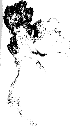
Figure 5 Results from decision tree of NDVI, NR34, and NR42 (Thailand Only)
Table 1 shows the results of the above classification procedures of individual and integrated steps.
According to the checking the areas from RED forest map (1991) shows a goad accuracy with a + 1.17 percent.
4. Conclusion: Results and Forest Mapping
4.1 Results obtained from the current study
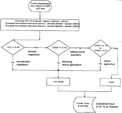
Figure 7 Decision tree for forest classification
4.2 Next topics to be further studies
In order to monitor forest area in such a wide area as Southeast Asia Peninsula, high resolution data set cannot easily be used for such a task because of the high volume of the data. Low resolution data such as NOAA AVHRR data set is a solution to such a task. A forest classification technique by using band 1, 2 3, and 4 of NOAA AVHRR including thermal bands is proposed in this study for more prices tropical forest classification, The accuracy was checked with the referenced forest map produced in 1991 by Royal Forest Department (RED) in Thailand, which showed only 1.17 percent discrepancy
1. Introduction
This research study tries to utilize low resolution data (cloud free mosaic of NOAA AVHRR LAC 1.1 km resolution) to monitor forest change in regional level for the purpose of management and planning The advantages of the use of low resolution satellite data (NOAA AVHRR) data are :
The advantages of the use of low resolution satellite data (NOAA AVHRR) data are :
- Wide area coverage
- More frequency of obtaining input data
- Wide area coverage
- More frequency of obtaining input data
- inaccurate Classification of Small Forest Area Dess than 1.1 KM2
- Inaccurate classification of sub region that forest area may have differed characteristics.
This relatively cloud free AVHARR mosaic, which is the primary product of grid Bagkok is used as the tested data, The mosaic covers an area extending from East 81 degree to East 120 degree, and from North 29 degree to South 10 degree. The mosaic is composted from 38 selected daily AVHRR images recorded by NOAA -11 (afternoon pas) along 10 different orbits between 12 November 1990 and 2 March 1991.
The AVHRR HRPT Level 1b data were received by the Thailand Meteorological Department receiving station on a daily basis. Each 4-band image was geo-referenced by GRID-Bangkok at 1.1 kilometer resolution (actually 1/100 oa degree) into a Plate Carrie Projection
The geometric accuracy of about 1 pixel is reached using a two step rectification algorithm (orbital model and transformation by ground control points) The cloud screening algorithm uses NDVI and the band 4 to composite the daily images. No radiometric calibration or atmospheric correction is done (grid Bangkok 1992).
3. Methodology for Forest Classification
3.1 The reference data : Forest map by RFD (1991)
The reference data (Thailand's forest area 1991) came from the interpretation of Lansat 5 data in the scale of 1:250,000 took in 1991 Jarsput 1993 Thailand has forest area left about 136698 sq. Km or 26.64 percent of the area of the whole cournty
3.2 Expected result from this stage
At this stage forest map with 2 classified classed (forest non-forest) should be able to obtain. By first, the result forest/non forest map of Thailand classified by proposed method should be compared to the referenced forest map (1991) from the Royal Forest Department to check for the accuracy of the proposed calssification method. Then forest/non forest map of the whole study area including Thailand, Myanmar, Laos, Cambodia and vetnam area is generated.
3.3 Classification with low resolutin data
Until now, the research study has been done on multi-spectral analysis with not only Isabelle and infrared bands but also thermal bands by using mainly IDRISI software for analysis task (please see Figure 1 for forest classification framework). But the multi-resolution framework is already planned, and it will be studies d net to improve the result.
Figure 1 Forest classification framework with multispectral data sets
3.3.1. Trend study
In order to study the relationship between each parameter that may be used for the forest classification, trend study has been preformed on tested data by
Step 1 Profile checking between clearly classified forest and non-forest area to identify any relationships between tested parameters and the characteristic of forest area. (please see Figure 2 for the graph of the selected profiles)
Figure 2 Sample selected profiles across (a) clearly forest/non-forest area (Kao Yai National Park) and (b) active agriculture area (Central Plain)
This procedure is consisted of the following :
- Select a testing vector that pass trough the interested area in question
- Obtain pixel values along the testing vector from each band, or normalized difference index of interest.
- Plot the graph of all data obtained, and study the relationship of the parameter in question
This procedure is consisted of the following :
- Display the studied data from each band or index of interested.
- Overlay with digitized forest/non forest map from RED.
- From the overlaid image, the visual inspection of the result can be performed to make to adjustment of parameter (s)
This procedure is consisted of the following:
- Select sample area that is clearly identify as forest area from the overlaid forest map from RFD.
- Window the selected area to make the histogram of that area. Then the histogram will be studies for the statistics of the interested parameters
2 NR 34 (Normalized Difference index between band 3 and band 4) = (band3-band4)= / (band 3 + band4)
3 NR42 (Normalized Difference Index between band 4 and band 2) = (nand4-band2)/(band4+band2)
3.3.2 NDVI and other normalized difference indices for forest classification
The following three steps with specific thresholds were defined with six xelected profiles over well known forest and agricultural lands in Thailand for example Kao Yai National Park and Central Plain.
Step 1: Define threshold value of NDVI for dense vegetation (NDVI > 0.30 will be defined as forest and dense agriculture)
The normalized difference vegetation index (NDVI) is one such ratio which has been shown to be highly correlated with vegetation parameters biomass and green leaf area and hence is of considerable, value for vegetation discrimination (Curran 1980) . But one of the draw back of NDVI is that a cannot clearly distinguish between forest and dense agriculture area since it only detect the chlorophyll reflectance.
The additional information of the finding are :
- The result not exactly match the classified data from RFD (more forest land)
- The result can not differentiate between forest and active
agriculture land (land in the central part of Thailand). (please see
Figure 3 for the classified result with NDVI)
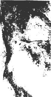
Figure 3 Classified result from NDVI
Since we can not use NDVI only to classify forest land. from the experiment and analysis, normalized difference index between band 3 and band 4 can assist in the classification of the forest land because normalized difference e index between band 3 and band 4 can identify clear boundary of forest if we select appropriate threshold. The reason for the assumption came from the fact the value of band 4 (thermal band ) from forest land is less than its surrounding while the value of band 3 of forest land still high (please see graph of profile vector across forest area in Figure 2a) so the normalized difference index between band 3 and band 4 will able to assist in denitrifying forest land. From the examination, the value of greater than or equal to 0.19 of such an index can be used to assist in identifying forest boundary.
The additional information of the finding are :
- The result not exactly match the classified data from RFD (more forest land).
- The result can differentiate between forest and very active
agriculture land (ex agriculture land in the central part of Thailand ).
(please see figure 4 for the classified result with normalized
difference index of band 3 and band 4)
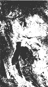
Figure 4 Classified results from NR34
From the study, we also found out that normalized difference index between land 4 and land 2 can also delineate active agriculture area from the classified forest land as defined in up to step 2. In this study, it was found that a range between 0.19 and 1.27 of NR 42 corresponds to active agricultural land. This assumption can be examined from the profile across the agriculture land in Thailand s central part (please see graph of profile vector across agriculture area in Figure 2b). The result of the combination of step 1 through step 3 is shown in Figure 5.
Figure 5 Results from decision tree of NDVI, NR34, and NR42 (Thailand Only)
Table 1 shows the results of the above classification procedures of individual and integrated steps.
According to the checking the areas from RED forest map (1991) shows a goad accuracy with a + 1.17 percent.
4. Conclusion: Results and Forest Mapping
4.1 Results obtained from the current study
- Combinations of visible near infrared, and thermal infrared in
themes of NDVI are definitely necessary to refine the tropical region
because some agricultural lands show very high which cannot be
delineated by NDVI see decision tree for forest classification . 7)
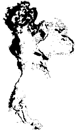
Figure 6 Forest Map of Thailand 1991
- The accuracy of forest area was high with a little higher value 27 . 81 compared with 26.64 percent (RED) the current thresholds involve very denss plantation, secondary forest, and fruit crop which are considered spectrally as same as land.
Figure 7 Decision tree for forest classification
4.2 Next topics to be further studies
- Selection of proper profiles ofr checking ground truth
- Verification of forest area with high reason data
- Sub-classification of forest land
- Change analysis of forest area
- Curran 1980 Curran P.J. 1980 Multispectral Remote Sensing of Vegetation Amount Prog. Phys Geogr 4,315
- (GRID 1992 ) GRID, Bankgkok, 1992. Document for NOAA AVHRR dateset.
- (Jaraput 1992) Jaruput, Thongchai, Analysis of Forest Situation in Thailand and the World, Royal Forest Department 1993
- Murai S., (editor) Applications of Remote Sensing in Asia and Oceania Environment Change Monitoring Asia Association on Remots Sensing 1991
- Murai S., (Editor) Remote Sensing Note, Japan Association OF Remote Sensing 1993
- Murai S., Special Course ON Advanced Remote Sensing Gis Technologies Data Fusion OF Multi- sensor Date, AIT, Bankok, Thailand 1994