| GISdevelopment.net ---> AARS ---> ACRS 1994 ---> Forestry |
Forest Fires Monitoring and
Assessment by using TM Images
Dr. Suvit Vibulsresth, Dr. Surachai Ratanasermpong, Rasamee Suwanweekakamtorn
Thailand Remote Sensing Division
National Research Council
Dr. Suvit Vibulsresth, Dr. Surachai Ratanasermpong, Rasamee Suwanweekakamtorn
Thailand Remote Sensing Division
National Research Council
Abstract
Forest fire during the dry season has long been a common occurrence in expanses of moxed deciduous and dry dipterocarp forest throughout te country. Forest fires play an important role in keeping the ecological balance in a forest especially the annual surface forest fire in dry dipterocarp forest. The deciduous fourest extinguish naturally when the rain comes after fires and it will turn green again in a few weeks. Forest fires in Thailand are primarily man-made.
Annual forest fire can be observed in Huai Kha Khaeng Wildlife Sanctuary in Uthai Thani Province which has become Thailand's first would heritage site since 1991. The assesment and monitoring of forest fire can be carried out by using Landsat TM imagery recorded in late dry season of 1988-1994. It was found that 1) the forest fire in 1994 is more severe than ever and burnt a large area of mixed defiduous and dry dipterocarp forest in the Wildlife Sancturary, 2) total damaged area as estiate from Landsat TM image acquired on March 6, 1994 and April 7, 1994 is approximately 1,144 sq. km. And 3) the false color composite of tM bands 457/ BGR showed clearly the active flame as fed yellow, burnt area in brown deciduous forest in greenish yellow and evegreen forest in blue.
Introduction
The forest fire in Thailand has annually occurred in dry season, the period of which the weather is usually hottest and driest. It has been a common occurrence in expanses of dry dipterocarp, mixed deciduous and pine forest throught the country.
According to Ketpraneet, et.al. (1991), forest fire is defined as an uncontained and freely spreading combustio which consumes the nutural fuels of either a forest or a plantation or a grassland or a shifting cultivation area, that is, duff litter, grass, dead branch wood, snags, logs, stumps, weeds, brush foliage, and to a limited degree, green trees. Three kinds of forest fires are recognized, based on the degree to which fuels from mineral soil upward to treetops are involved in combustion; ground. Sufface and crown fires.
The forest fire in tnanand is annuany occoring senerally surface fire with low to moderate fire intensity. Cause of forest fire are muman activities such as intentional lighting, lighting fire for annuasement, forest travellers, burning for farming site preparation, hunters, smokers, et. Forest area was annually burned by a average of 31,200sq. km. Or about 20.92% of total forest area: dry dipterocarp 16.9% mixed deciduous 57.3%, evergreen 22.9% if pine 0.9%, grass land 1.9% and other 0.1%
Objective
The objective f the study is to monitor and assess forest fire in Huai Kha Khaeng wildlife Sanctuary (HKKWS) by using TM imagery.
Study Area
The HKKWS is located in Uthai Thani, Kanchanaburi and Tak provinces, west of ailand with forest coverage area of appoximately 2800 sq.km. (Figure 1) It traddles the Shan Thai mountains at the jonction Dawna and Tenmasserim ranges. Most of the area is mountainous but sizeable area of lowland forests occur in the river valleys.
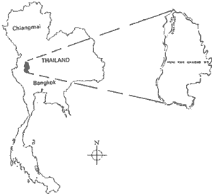
Figure 1 The study area : Huai Kha Khaeng Wildlife Sanctuary.
The vegetation of HKKWS is a mosaic of evergreen and deciduous forest formations. Approximately 50% of the sanctuary support deciduous forest and 40% support seasonal evergreen or semi-evergreen formations. The remaining areas include pure stand of bamboo (3%), past and present swiddens (3%) and a very small area of pine forest (Nakhasathien and Stewart-Cox 1990)
Methodology
Temporal cloud free Landsat TM images recorded in dry season were used fro annual forest fire assessment;
6 April 1988
20 February 1989
12 April 1990
26 February 1991
16 March 1992
4 April 1993
Temporal could free Landsat TM images recorded in early-late dry season were used for forest fire monitoring:
17 January 1994 before forest fire occurrence.
2 February 1994 at the beginning of the fire.
18 February 1994 during forest fire occurrence.
6 March 1994 during forest fire occurrence.
7 april 1994 after the fire had ceased.
The visual interpretation of transparency film of Landsat TM imagery of 1988 1993 was carried out by using PROCOM-II projector while the enhanced TM bands 457 BGR of March 16, 1994 ad April 17, 1994 were overlaid and analysed by using MERIDIAN IMAGE ANALYSIS SYSTEM. The forest fire maps were obtained and calcualated.
Results
It is importaint to select proper spectral bands such as IR bands of Landsat TM ie. 457/B G R for forest fire monitoring and assessment. This combination yields andd excellent representation of forest fire particulary on active flame that should be useful for forest tendings and forest fire control activities. Satellite imagery could help enhance forest fire research emphatically on fire behavior for further utilization in forest fire control planning.
Reference
Forest fire during the dry season has long been a common occurrence in expanses of moxed deciduous and dry dipterocarp forest throughout te country. Forest fires play an important role in keeping the ecological balance in a forest especially the annual surface forest fire in dry dipterocarp forest. The deciduous fourest extinguish naturally when the rain comes after fires and it will turn green again in a few weeks. Forest fires in Thailand are primarily man-made.
Annual forest fire can be observed in Huai Kha Khaeng Wildlife Sanctuary in Uthai Thani Province which has become Thailand's first would heritage site since 1991. The assesment and monitoring of forest fire can be carried out by using Landsat TM imagery recorded in late dry season of 1988-1994. It was found that 1) the forest fire in 1994 is more severe than ever and burnt a large area of mixed defiduous and dry dipterocarp forest in the Wildlife Sancturary, 2) total damaged area as estiate from Landsat TM image acquired on March 6, 1994 and April 7, 1994 is approximately 1,144 sq. km. And 3) the false color composite of tM bands 457/ BGR showed clearly the active flame as fed yellow, burnt area in brown deciduous forest in greenish yellow and evegreen forest in blue.
Introduction
The forest fire in Thailand has annually occurred in dry season, the period of which the weather is usually hottest and driest. It has been a common occurrence in expanses of dry dipterocarp, mixed deciduous and pine forest throught the country.
According to Ketpraneet, et.al. (1991), forest fire is defined as an uncontained and freely spreading combustio which consumes the nutural fuels of either a forest or a plantation or a grassland or a shifting cultivation area, that is, duff litter, grass, dead branch wood, snags, logs, stumps, weeds, brush foliage, and to a limited degree, green trees. Three kinds of forest fires are recognized, based on the degree to which fuels from mineral soil upward to treetops are involved in combustion; ground. Sufface and crown fires.
The forest fire in tnanand is annuany occoring senerally surface fire with low to moderate fire intensity. Cause of forest fire are muman activities such as intentional lighting, lighting fire for annuasement, forest travellers, burning for farming site preparation, hunters, smokers, et. Forest area was annually burned by a average of 31,200sq. km. Or about 20.92% of total forest area: dry dipterocarp 16.9% mixed deciduous 57.3%, evergreen 22.9% if pine 0.9%, grass land 1.9% and other 0.1%
Objective
The objective f the study is to monitor and assess forest fire in Huai Kha Khaeng wildlife Sanctuary (HKKWS) by using TM imagery.
Study Area
The HKKWS is located in Uthai Thani, Kanchanaburi and Tak provinces, west of ailand with forest coverage area of appoximately 2800 sq.km. (Figure 1) It traddles the Shan Thai mountains at the jonction Dawna and Tenmasserim ranges. Most of the area is mountainous but sizeable area of lowland forests occur in the river valleys.
Figure 1 The study area : Huai Kha Khaeng Wildlife Sanctuary.
The vegetation of HKKWS is a mosaic of evergreen and deciduous forest formations. Approximately 50% of the sanctuary support deciduous forest and 40% support seasonal evergreen or semi-evergreen formations. The remaining areas include pure stand of bamboo (3%), past and present swiddens (3%) and a very small area of pine forest (Nakhasathien and Stewart-Cox 1990)
Methodology
Temporal cloud free Landsat TM images recorded in dry season were used fro annual forest fire assessment;
6 April 1988
20 February 1989
12 April 1990
26 February 1991
16 March 1992
4 April 1993
Temporal could free Landsat TM images recorded in early-late dry season were used for forest fire monitoring:
17 January 1994 before forest fire occurrence.
2 February 1994 at the beginning of the fire.
18 February 1994 during forest fire occurrence.
6 March 1994 during forest fire occurrence.
7 april 1994 after the fire had ceased.
The visual interpretation of transparency film of Landsat TM imagery of 1988 1993 was carried out by using PROCOM-II projector while the enhanced TM bands 457 BGR of March 16, 1994 ad April 17, 1994 were overlaid and analysed by using MERIDIAN IMAGE ANALYSIS SYSTEM. The forest fire maps were obtained and calcualated.
Results
- The result of the study reveals that the false color composite of TM
bands 457/BGR showed clearly the forest fire such as : active flame as
red yellow, burn area in brown, deciduous forest in greeish yellow and
evegreen forest in blue (Figure 2)
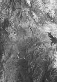
Figure 2 Landsat TM band 457/ B G R recorded on March 6, 1994. Burnt area : brown, active flame : red-yellow, evergreen forest : blue and deciduous forest : greenish
- The The affected forest area from forest fire as interpreted from
Landsat imagery recorded in late dry season in 1988, 1989, 1990, 1991,
1992 , 1993 ad 1994 are approximately 445 sq. km. 160 sq. km, 0 sq. km.
(no forest fire) 400 sq. km. 980 sq. km. 40 sq. km and 1,144 sq. km.
Respectively (Figure 3)
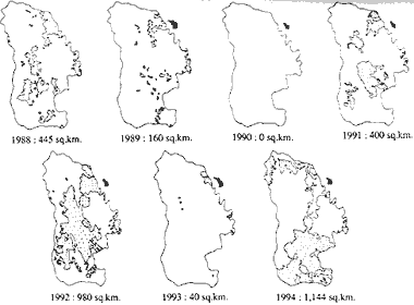
Figure 3 Burnt forest areas derived from interpretation of Landsat TM recorded in 1988 - 1994.
- Forest fire in HKKWS in 1994 was found to be more severe than ever. It afects the forest ecosystem such as vegetation soil water air scenic beauty and wildlife. It was found that the forest fire is more disadvantaged than advantaged. On eonomic aspect dry dipterocarp forest and mixed deciduous forest have been valued to have a monetry average of about US $ 100,000 per sq. km. (Ketpraneet and et. Al. 1991) So, the deciduous forest of HKKWS was totally US$ 1,144 milion lost.
It is importaint to select proper spectral bands such as IR bands of Landsat TM ie. 457/B G R for forest fire monitoring and assessment. This combination yields andd excellent representation of forest fire particulary on active flame that should be useful for forest tendings and forest fire control activities. Satellite imagery could help enhance forest fire research emphatically on fire behavior for further utilization in forest fire control planning.
Reference
- Ketpraneet, S. ad et. al. 1991. Forest Fire and Effects of Forest Fire on Forest System in Thailand Kasetsart Uiversity, Bagkok, Thailand.
- Nakhasathien S. and B. Stewart Cox 1990 Nomination of the Thung Yai Huai Kha Khaeg Wildlife Sactuary to be a UNESCO world heritage Site. Wildife conservation Divisio, Royal Forest Department. Bangkok, Thailand.