| GISdevelopment.net ---> AARS ---> ACRS 1994 ---> Disasters |
Antecedent Precipitation
Index – A Dual Approach Between Soil Moisture and Normalized Difference
Vegetation Index (NDVT) as An Input to GIS Based Locust Control and
Surveillance
Rajashree V Bothale, Dibyendu Dutta and J R Sharma
Regional Remote sensing Service Centre, Jodhpur 342 003
Rajashree V Bothale, Dibyendu Dutta and J R Sharma
Regional Remote sensing Service Centre, Jodhpur 342 003
Abstract
In the present study, a Cumulative corrected Antecedent Precipitation Index (CCAPI) as an index of profile moisture has been derived which correlates well with the Normalised Difference Vegetation Index (NDVI) of satellite based remote sensing data in parts of Western Rajasthan. Daily rainfall data and monthly average data of other weather parameters along with soil moisture holding informations were used to calculate CCAPI. The correlation between CCAPI and NDVI was highly significant (r=0.74*). API values when compared with some field soil measurement showed correlation of 0.80 and 0.78 with volumetric and gravimetric soil moisture respectively. NDVI was found to relate well during peak growing season with natural desert vegetation. These comparisons helped in assessing CCPI as a single substitute for variable attributes to be used in GIS locust control and surveillance.
Introduction
Real time information of soil surface and profile moisture is a formidable task to predict different hydrological processes in advance. Large number of efforts have been made to arrive at soil moisture information from rainfall and other bioclimatic factors. The gravimetric soil sampling has its own limitations by having highly heterogeneous matric and also needs a large number of sample which require lot of time and manpower for analysis. Any method which can be used readily with sufficient accuracy is what is actually required to predict unforeseen circumstances in desert terrain. An index which includes rainfall, soil parameters and meteorological variables would claim as a practical and realistic approach for instant information on soil moisture. The cumulative information of soil moisture as profile storage can also be used to predict the probable growth and development of ephemeral vegetations.
Western districts of Rajasthan are prone to locust breeding and migration. The present study integrates the three most important variable attributes, viz. rainfall, soil moisture and vegetation which are directly responsible for locust breeding and proliferation by a single parameter, API. Considerable effort have been made by other scientists to relate API with microwave brightness temperature (Choudhary et.al., 1988; Wang, J.R 1985) but meager informations are available regarding the relation between API and satellite based NDVI especially in arid desertic tracks of Western Rajasthan having sparse vegetation cover and difficult accessibility. Hence it was decided to find a relation among the tree parameters in order to use Antecedent Precipitation Index (API) in absence of intensive soil moisture sampling of to arrive at a Geographic information system for locust control and surveillance.
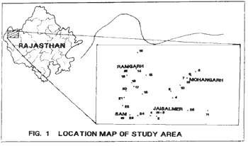
Study Area
The study are lies between 70030’ to 72025’E longitude & 26045’ to 28000’ N latitude covering parts of Jaisalmer district. The area is mostly covered by loose mentle of Aeolian sand with texture varying from sandy to sandy loam. The soils are characteristically stratified belonging to Torrifluvents and Torripsamments type. General topography in the area varies from dunes and interdunal plains to river plains. Landuse/wastelands n the form of sandy area, rock outcrops and land with or without scrub. Agricultural land and plantations are observed along the canal running across the study area.
The entire study area was geographically stratified into five different zones by Thiessen polygon method and all the soil sampling sites were put together under different outpost rainfall recording stations.
Table 1 : Distribution of soil sampling sites under the influence zone of different rainfall stations.
Methodology
Antecedent Precipitation Index (API)
API is a measure of soil moisture condition on the day under consideration & was calculated using Linsely et. al. (1949) model :
It = Kt * It-1 + Pt
Where,
It = API on ‘t’ the day (mm)
It–1 = API on ‘t-1’ the day (mm)
Pt = Precipitation on ‘t’ the day (mm)
Kt = recession constant
Again , the recession constant ‘kt’ was calculated following the method given by Chodhury and Blanchard (1983):
Kt = EXP (-Et/Wm)
Where,
Et = Potential evaporation on ‘t’ th day
Wm = maximum soil moisture available for evaporation (mm)
= WHC/100) * BD * 100 (mm)
Monthly average potential evaporation of Jaisalmar station was calculated using Thornthwaite (1948) model as a representative for all stations and presented in Table – 2.
Monthly soil moisture available upto 10 cm top soil available upto 10cm top soil for evaporation for different sites were calculated and listed in table 3
Table 2 : Average daily potential evapotranspiration (PET) over Jaisalmar station.
Table 3 : Maximum available soil moisture (Wm) of surface soil (0-10 cm)
Table 4 gives the average recession constant values for different months using the meteorological data of Jaisalmar station.
Table 4: Monthly recession constant (Kt) values
Datewise rainfall value (in mm) has been recorded (1st Pre-monsoon rain onward till lat monsoon shower) from regional centre of Central Arid Zone Research Institute located at Jaisalmar. From 1st rain onward API was calculated from each date and site upto 5th October (date of soil sampling) and finally corrected cumulative API (CCAPI) was computed fro three satellite DOP since 1st onset of rain as follows :
CCAPI = (API – WP)
Where, WP = Silting point of the soil at given location
This CCAPI was considered as an index which determines the growth and vigour of ephemeral desert vegetation.
Soil analysis
Representative soil samples (0-20 cm depth) from different locust breeding sites were collected on 5th October’ 92 for gravimetric moisture (qg), field bulk density and water holding capacity and brought back to laboratory with due care to prevent any moisture loss during transit. Soils were analysed using methods given by Black (1965). Permanent wilting point (WP) was determined at 1.5 MPa metric potential using pressure membrane apparatus.
Vegetation Index
The IRS LISS I data of path 34 and row 48 for three different dates of pass (11.7.92, 24.8.92 and 15.9.92) in the red (0.62 – 0.68 mm) and near infrared (0.77 - 0.86 mm) band were used to generate normalized difference vegetation index (NDVI) by using the formula :
NDVI = (IR – R) / (IR + R)
Where IR and R are digital numbers in the near infra red bands respectively.
Soil sampling sites of the study area were identified on 1:250,000 toposheets and digitized for superimposition on IRS LISS I scenes to get NDVI/DN values over three dates of pass for the purpose of developing growth profile of the vegetation with advancing monsoon and to correlate NDVI/DN values with representative API values. All the IRS LISS I scenes were georeferenced and brought to 1:1 correspondence with each other before extracting NDVI/DN values.
Results and Discussion
Calculated values of API ranged from 0.66 (site No 21) to a high as 10.17 (site No 18) (table 5)
Out of 25 soul sampling points, only 17 points were sorted out based on the existing landuse having exhibited moderate to good growth during rainy season. Correlation matrix was computed related API, volumetric moisture (qv) and gravimetric moisture (qg). API values calculated for each site on the date of soil sampling showed significant positive correlation with volumetric (r - 0.81*) and gravimetric r = 0.78*) soil moisture. (Table 6). Rao et. al !(993) in a ground based study also have shown significant positive correlation between root zone soil moisture and NDVI in a vegetated crop field. Volumetric moisture found to give higher significant correlation than qg as a matter of fact that q considers soil bulk density also.
Table 5: calculated API, Volumetric and Gravimetric moisture status as on 5.10.92.
Table 6: Correlation metric showing interrelation among API, GM (qg) and VM (qv).
*Significant at 5% level only.
As the calculated API takes care of sol moisture, potential evaporation and rainfall and giving higher significant correlation with qg and qv it can be accepted as a n alternative to qg and qv even in desertic terrain. In reality field soil sampling is tedious and time consuming, besides it may not represent the entire area due to large soil spatial variability.
In another effort it was thought worthwhile to take cumulative value of API over the growing period as an index of moisture towards development of desert vegetation. Cumulative values of corrected API (CCAPI) for different sites are given in table 7.
Cumulative soil moisture over the growing period and locationwise mean NDVI/DN values of different dates of pass are given in Table 8.
Out of 3 different dates of pass CCAPI values found to be significantly and positively correlated (r = 0.74*) with 15.9.92 date of pass but CCAPI could not give significant correlation with other two DOP’s This may be attributed to the natural time lag between soil moisture and manifestation of canopy development. In dersert areas the poor vegetation status during onset of monsoon and short growing period of ephemerals could also be the reason for insignificant correlation during first two date of pass. But with advancing monsoon there is a good natural vegetation growth which gave significant correlation with CCAPI values.
Table 7: Calculated CCAPI of different sites on three different DOPs of IRS LISS I
Conclusion
Western districts of Rajasthan are prone to locust upsurge and breeding due to favourable bioclimatic conditions. The significant correlation of API integrates the three most important variables, viz. soil moisture, vegetation and rainfall, responsible for breeding and proliferation of locusts. In GIS for locust control and surveillance where variable attributes are combined with permanent attributes and other related informations to arrive at probable sites for locust upsurge, API/CCAPI can alone used successfully as a variable attributes.
Table 8: NDVI/DN & CCAPI values on 3 dates of pass for selected sites
Acknowledgement
Authors are grateful to Shri K Radhakrishnan, Director ?NNRMS/RRSSC for this constant encouragement. Sincere thanks are due to Dr D C Joshi and the staff of soil testing laboratory, CAZRI, Jodhpur for their help during the analysis of soil sample. The suggestions received from Dr. Jagdeesh Chandra, Jodhpur and the RRSSC staff are duly being acknowledged.
Refernces
In the present study, a Cumulative corrected Antecedent Precipitation Index (CCAPI) as an index of profile moisture has been derived which correlates well with the Normalised Difference Vegetation Index (NDVI) of satellite based remote sensing data in parts of Western Rajasthan. Daily rainfall data and monthly average data of other weather parameters along with soil moisture holding informations were used to calculate CCAPI. The correlation between CCAPI and NDVI was highly significant (r=0.74*). API values when compared with some field soil measurement showed correlation of 0.80 and 0.78 with volumetric and gravimetric soil moisture respectively. NDVI was found to relate well during peak growing season with natural desert vegetation. These comparisons helped in assessing CCPI as a single substitute for variable attributes to be used in GIS locust control and surveillance.
Introduction
Real time information of soil surface and profile moisture is a formidable task to predict different hydrological processes in advance. Large number of efforts have been made to arrive at soil moisture information from rainfall and other bioclimatic factors. The gravimetric soil sampling has its own limitations by having highly heterogeneous matric and also needs a large number of sample which require lot of time and manpower for analysis. Any method which can be used readily with sufficient accuracy is what is actually required to predict unforeseen circumstances in desert terrain. An index which includes rainfall, soil parameters and meteorological variables would claim as a practical and realistic approach for instant information on soil moisture. The cumulative information of soil moisture as profile storage can also be used to predict the probable growth and development of ephemeral vegetations.
Western districts of Rajasthan are prone to locust breeding and migration. The present study integrates the three most important variable attributes, viz. rainfall, soil moisture and vegetation which are directly responsible for locust breeding and proliferation by a single parameter, API. Considerable effort have been made by other scientists to relate API with microwave brightness temperature (Choudhary et.al., 1988; Wang, J.R 1985) but meager informations are available regarding the relation between API and satellite based NDVI especially in arid desertic tracks of Western Rajasthan having sparse vegetation cover and difficult accessibility. Hence it was decided to find a relation among the tree parameters in order to use Antecedent Precipitation Index (API) in absence of intensive soil moisture sampling of to arrive at a Geographic information system for locust control and surveillance.
Study Area
The study are lies between 70030’ to 72025’E longitude & 26045’ to 28000’ N latitude covering parts of Jaisalmer district. The area is mostly covered by loose mentle of Aeolian sand with texture varying from sandy to sandy loam. The soils are characteristically stratified belonging to Torrifluvents and Torripsamments type. General topography in the area varies from dunes and interdunal plains to river plains. Landuse/wastelands n the form of sandy area, rock outcrops and land with or without scrub. Agricultural land and plantations are observed along the canal running across the study area.
The entire study area was geographically stratified into five different zones by Thiessen polygon method and all the soil sampling sites were put together under different outpost rainfall recording stations.
Table 1 : Distribution of soil sampling sites under the influence zone of different rainfall stations.
| Rainfall Stations | Sites under the influence zone |
| Sri Mohangarh | 5,6,7,8,9,10,12,14,15,25 |
| Jaisalmar | 1,2,3,4,16,24 |
| Ramgarh | 17,18,19,20 |
| Sam | 21,22,23, |
| Pokran | 11 |
Methodology
Antecedent Precipitation Index (API)
API is a measure of soil moisture condition on the day under consideration & was calculated using Linsely et. al. (1949) model :
It = Kt * It-1 + Pt
Where,
It = API on ‘t’ the day (mm)
It–1 = API on ‘t-1’ the day (mm)
Pt = Precipitation on ‘t’ the day (mm)
Kt = recession constant
Again , the recession constant ‘kt’ was calculated following the method given by Chodhury and Blanchard (1983):
Kt = EXP (-Et/Wm)
Where,
Et = Potential evaporation on ‘t’ th day
Wm = maximum soil moisture available for evaporation (mm)
= WHC/100) * BD * 100 (mm)
Monthly average potential evaporation of Jaisalmar station was calculated using Thornthwaite (1948) model as a representative for all stations and presented in Table – 2.
Monthly soil moisture available upto 10 cm top soil available upto 10cm top soil for evaporation for different sites were calculated and listed in table 3
Table 2 : Average daily potential evapotranspiration (PET) over Jaisalmar station.
| Month | PET (mm) | Month | PET (mm) |
| Jan | 0.3 | Jul | 5.3 |
| Feb | 0.4 | Aug | 5.7 |
| Mar | 1.3 | Sep | 5.1 |
| Apr | 4.5 | Oct | 4.1 |
| May | 13.4 | Nov | 1.5 |
| Jun | 11.1 | Dec | 0.7 |
Table 3 : Maximum available soil moisture (Wm) of surface soil (0-10 cm)
| Site No | Wm | Site No | Wm | Site No | Wm |
| 1 | 33.2 | 9 | 32.8 | 18 | 71.3 |
| 2 | 28.9 | 10 | 49.1 | 19 | 49.3 |
| 3 | 64.8 | 11 | 38.3 | 20 | 35.3 |
| 4 | 36.6 | 12 | 37.4 | 21 | 34.8 |
| 5 | 41.1 | 14 | 36.6 | 22 | 33.9 |
| 6 | 30.5 | 15 | 38.4 | 23 | 35.8 |
| 7 | 35.1 | 16 | 44.8 | 24 | 37.6 |
| 8 | 36.2 | 17 | 39.5 | 25 | 42.5 |
Table 4 gives the average recession constant values for different months using the meteorological data of Jaisalmar station.
Table 4: Monthly recession constant (Kt) values
| Month | PET (mm) | Month | PET (mm) |
| Jan | 0.99 | Jul | 0.86 |
| Feb | 0.98 | Aug | 0.86 |
| Mar | 0.96 | Sep | 0.87 |
| Apr | 0.88 | Oct | 0.89 |
| May | 0.69 | Nov | 0.96 |
| Jun | 0.74 | Dec | 0.98 |
Datewise rainfall value (in mm) has been recorded (1st Pre-monsoon rain onward till lat monsoon shower) from regional centre of Central Arid Zone Research Institute located at Jaisalmar. From 1st rain onward API was calculated from each date and site upto 5th October (date of soil sampling) and finally corrected cumulative API (CCAPI) was computed fro three satellite DOP since 1st onset of rain as follows :
CCAPI = (API – WP)
Where, WP = Silting point of the soil at given location
This CCAPI was considered as an index which determines the growth and vigour of ephemeral desert vegetation.
Soil analysis
Representative soil samples (0-20 cm depth) from different locust breeding sites were collected on 5th October’ 92 for gravimetric moisture (qg), field bulk density and water holding capacity and brought back to laboratory with due care to prevent any moisture loss during transit. Soils were analysed using methods given by Black (1965). Permanent wilting point (WP) was determined at 1.5 MPa metric potential using pressure membrane apparatus.
Vegetation Index
The IRS LISS I data of path 34 and row 48 for three different dates of pass (11.7.92, 24.8.92 and 15.9.92) in the red (0.62 – 0.68 mm) and near infrared (0.77 - 0.86 mm) band were used to generate normalized difference vegetation index (NDVI) by using the formula :
NDVI = (IR – R) / (IR + R)
Where IR and R are digital numbers in the near infra red bands respectively.
Soil sampling sites of the study area were identified on 1:250,000 toposheets and digitized for superimposition on IRS LISS I scenes to get NDVI/DN values over three dates of pass for the purpose of developing growth profile of the vegetation with advancing monsoon and to correlate NDVI/DN values with representative API values. All the IRS LISS I scenes were georeferenced and brought to 1:1 correspondence with each other before extracting NDVI/DN values.
Results and Discussion
Calculated values of API ranged from 0.66 (site No 21) to a high as 10.17 (site No 18) (table 5)
Out of 25 soul sampling points, only 17 points were sorted out based on the existing landuse having exhibited moderate to good growth during rainy season. Correlation matrix was computed related API, volumetric moisture (qv) and gravimetric moisture (qg). API values calculated for each site on the date of soil sampling showed significant positive correlation with volumetric (r - 0.81*) and gravimetric r = 0.78*) soil moisture. (Table 6). Rao et. al !(993) in a ground based study also have shown significant positive correlation between root zone soil moisture and NDVI in a vegetated crop field. Volumetric moisture found to give higher significant correlation than qg as a matter of fact that q considers soil bulk density also.
Table 5: calculated API, Volumetric and Gravimetric moisture status as on 5.10.92.
| Site No | API | VM (qv) | GM (qg) |
| 1. | 1.52 | 0.020 | 1.28 |
| 2. | 1.27 | 0.046 | 3.55 |
| 3. | 5.00 | 0.009 | 0.62 |
| 4. | 1.74 | 0.034 | 2.44 |
| 5. | 1.45 | 0.192 | 13.76 |
| 6. | 0.33 | 0.062 | 6.05 |
| 7. | 0.71 | 0.013 | 0.96 |
| 8. | 0.94 | 0.220 | 14.69 |
| 9. | 0.48 | 0.015 | 1.00 |
| 10. | 2.78 | 0.073 | 6.72 |
| 11. | 1.04 | 0.009 | 0.59 |
| 12. | 0.95 | 0.033 | 2.03 |
| 14. | 0.95 | 0.024 | 1.83 |
| 15. | 1.00 | 0.012 | 0.83 |
| 16. | 2.46 | 0.057 | 4.49 |
| 17. | 1.39 | 0.014 | 0.97 |
| 18. | 10.17 | 0.057 | 3.63 |
| 19. | 3.2 | 0.032 | 2.31 |
| 20. | 0.72 | 0.025 | 1.83 |
| 21. | 0.66 | 0.042 | 2.98 |
| 22. | 0.68 | 0.022 | 1.63 |
| 23. | 0.72 | 0.019 | 1.36 |
| 24. | 1.75 | 0.009 | 0.59 |
| 25. | 1.54 | 0.037 | 2.72 |
Table 6: Correlation metric showing interrelation among API, GM (qg) and VM (qv).
| API | GM (qg) | VM (qv) | R |
| API | 1.0 | 0.78* | 0.81* |
| GM | 0.78* | 1.00 | 0.98* |
| VM | 0.81* | 0.98* | 1.00 |
As the calculated API takes care of sol moisture, potential evaporation and rainfall and giving higher significant correlation with qg and qv it can be accepted as a n alternative to qg and qv even in desertic terrain. In reality field soil sampling is tedious and time consuming, besides it may not represent the entire area due to large soil spatial variability.
In another effort it was thought worthwhile to take cumulative value of API over the growing period as an index of moisture towards development of desert vegetation. Cumulative values of corrected API (CCAPI) for different sites are given in table 7.
Cumulative soil moisture over the growing period and locationwise mean NDVI/DN values of different dates of pass are given in Table 8.
Out of 3 different dates of pass CCAPI values found to be significantly and positively correlated (r = 0.74*) with 15.9.92 date of pass but CCAPI could not give significant correlation with other two DOP’s This may be attributed to the natural time lag between soil moisture and manifestation of canopy development. In dersert areas the poor vegetation status during onset of monsoon and short growing period of ephemerals could also be the reason for insignificant correlation during first two date of pass. But with advancing monsoon there is a good natural vegetation growth which gave significant correlation with CCAPI values.
Table 7: Calculated CCAPI of different sites on three different DOPs of IRS LISS I
| Site | CCAPI on | ||
| 11.7.92 | 24.8.92 | 15.9.92 | |
| 1. | -9.99 | 755.27 | 852.71 |
| 2. | -17.91 | 552.66 | 711.63 |
| 4. | -6.24 | 106.77 | 922.10 |
| 5. | -1.04 | 216.65 | 546.80 |
| 6. | 07.8 | 149.40 | 298.81. |
| 7. | 3.7 | 181.21 | 459.70 |
| 8. | -9.12 | 180.48 | 469.70 |
| 10. | -6.69 | 232.17 | 1233.82 |
| 11. | 0.00 | 384.50 | 707.56 |
| 12. | -19.02 | 160.83 | 424.44 |
| 14. | 11.49 | 99.55 | 385.93 |
| 15. | -17.88 | 164.90 | 458.53 |
| 16. | -11.22 | 918.34 | 1261.16 |
| 17. | 0.00 | 315.92 | 684.05 |
| 18. | 0.00 | 358.71 | 820.63 |
| 19. | 0.00 | 297.21 | 608.57 |
| 20. | 0.00 | 297.21 | 608.57 |
| 21. | 125.68 | 895.35 | 1220.63 |
| 22. | 118.06 | 878,35 | 1220.63 |
| 23. | -9.25 | 530.21 | 1221.19 |
| 24. | 4.41 | 217.18 | 738.27 |
| 25. | 119.44 | 896.09 | 541.13 |
Conclusion
Western districts of Rajasthan are prone to locust upsurge and breeding due to favourable bioclimatic conditions. The significant correlation of API integrates the three most important variables, viz. soil moisture, vegetation and rainfall, responsible for breeding and proliferation of locusts. In GIS for locust control and surveillance where variable attributes are combined with permanent attributes and other related informations to arrive at probable sites for locust upsurge, API/CCAPI can alone used successfully as a variable attributes.
Table 8: NDVI/DN & CCAPI values on 3 dates of pass for selected sites
| Site No. | 11.7.92 | 24.8.92 | 15.9.92 | |||
| NDVI/DN | CCAPI | NDVI/DN | CCAPT | NDVI/ND | CCAPI | |
| 4 | 162 | -6.24 | 179 | 106.77 | 161 | 922.10 |
| 5 | 131 | -1.04 | 123 | 216.65 | 110 | 546.80 |
| 6 | 128 | -7.80 | 117 | 149.41 | 121 | 298.81 |
| 7 | 129 | 3.70 | 101 | 181,21 | 84 | 459.70 |
| 9 | 119 | -5.96 | 105 | 183.67 | 94 | 441.02 |
| 10 | 131 | -6.69 | 103 | 232.17 | 86 | 590.91 |
| 12 | 164 | -19.02 | 132 | 160.83 | 124 | 424.44 |
| 14 | 135 | 11.49 | 118 | 99.55 | 111 | 385.93 |
| 16 | 159 | -11.22 | 161 | 918.34 | 162 | 1261.16 |
| 17 | 148 | 0 | 128 | 315.92 | 144 | 684.05 |
| 19 | 155 | 0 | 132 | 358.71 | 133 | 820.63 |
| 21 | 137 | 125.68 | 130 | 895.63 | 129 | 1233.82 |
| 25 | 136 | 4.41 | 117 | 217.18 | 114 | 541.19 |
Acknowledgement
Authors are grateful to Shri K Radhakrishnan, Director ?NNRMS/RRSSC for this constant encouragement. Sincere thanks are due to Dr D C Joshi and the staff of soil testing laboratory, CAZRI, Jodhpur for their help during the analysis of soil sample. The suggestions received from Dr. Jagdeesh Chandra, Jodhpur and the RRSSC staff are duly being acknowledged.
Refernces
- Applied Hydrology by Muttreja L N, 1990 Tat McGraw Hill, New
Delhi.
- Black, C.A 1965, Methods of soil analysis, Part 1, Monograph No 9,
Agronomy series, Madison USA.
- Blanchard, B.J, Schumugge, T.J and Rhoades, E, 1981, Estimation of
Soil Moisture with API Algorithms and Microwave emission. Water
resources Bulletin 17, 767-774.
- Choudhary, B.J and Venkatratnam L., Rao P. V.K., Ramana K.V, 1993,
Relation between soil moisture and normalized difference vegetation
Index of vegetated fields. Int Journal of Remote Sensing, 14 (4) :
444-449.
- Teng, W.L, Wang J.R and Doraiswamy P.C 1993 Relationship between
satellite microwave radiometric data, API and regional soil moisture,
Int. Journal of Remote Sensing, 14 (13) : 2483 – 2500.
- Wang, J.R 1985, Effect of Vegetation on soil moisture sensing
observed from orbiting microwave radiometers, Remote Sensing of
Environment, 17,
141-151.