| GISdevelopment.net ---> AARS ---> ACRS 1994 ---> Disasters |
Monitoring and forecast of
disasters in bangladesh using remote sensing technology
Dr. A. M.
Choudhury
Bangladesh Space Research and Remote
Sensing Organizatoin (SPARRSO),
Agargaon, Sher-e-Bangla Nagar,
Dhaka-1207.
AbstractBangladesh Space Research and Remote
Sensing Organizatoin (SPARRSO),
Agargaon, Sher-e-Bangla Nagar,
Dhaka-1207.
Bangladesh is a victim of natural disasters like floods and cyclones. About one fifth of the county is flooded every year and in a catastrophic flood like that of 1988, more than half of the country can be flooded. Again Bangladesh is afected by tropoical cyclones almost every year and some of them are very catastrophic like those of 1970 and 1991. These calmities cause huge loss of lives and property. Argents this backdrop an Advanced Meteroolgical Ground Station was established in Bangladesh with financial support from US-AID and technical in Bangladesh with financial support from US-AID and technical assistance from NASA. The station is capable of receivng data from NOAA and GMS satellites at frequent intervals. The imagery receied from these satellites are used for routine weather as well as disaste forecasting. The paper is illustrated by flood pictures obtained for 1987 and 1988 floods and cyclones of 1970, 1985, 1988, 1991 and 1994 and 1994. In the case of cyclone, intensity estimation is made from degree of organization of the cloud using Dvorak method. Cyclone track foreacast method named TYAN developed by NASA originally for the Pacific and modified for the Bay of Bangal Cyclones has been found to indicate the area affected by the cyclone at least 24 hours in advance quite accurately.
Introduction
Bangladesh currently ranks as the world's foremost disaster-prone country. The situation is aggravated, all the more by its being the most densely populated country in the world. Environmental disasters like tropical cyclones, storm surges, floods, norwesters, tornadoes and droughts ravage the country almost every year. During the last thirty two years, the country was devastated by thirty five severe cyclones of varying intensities, the fiercest one was of 29 April 1991, when material damage was to the tune of about 2.4 billion US dollars and human casualty of about 1,40,000 lives. On a previous occasion of a similar catastrophe in 1970, about half a million lives were lost. As a comparison the hurricane Andrew, even stronger than 1991 cyclone of Bangladesh, which struck the Florida coast of USA in 1992 led to the casualty of no more than twenty human lives spread over four countries. The river Huang Ho in China which used to cause millions of deaths by flooding some hundred years back is no longer called the flood of 1988 caused economic loss to the extent of about one billion dollar2. And flooding in Bangladesh is a perennial problem. These disasters put the clock of our economic growth just backwards. Unless we can adequately deal with them, our economic progress will remain a dream onlyThe physical cause of these disasters are embodied in laws of science and hence proper scientific research is necessary to deal with them. This paper gives a brief description of monitoring and forcast of cyclones and floods in Bangladesh using remote sensing technology.
TropicaL Cyslones
The tropics can be regarded as the region of the earth lying between 30on latitude and 30 o S latitude All the tropical seas of earth with the exception of the south Atlantic and east south Pacific give birth ot deadly atmospheric phenomena known as tropical cyclones. On the average, 80 tropical cyclones are formed every year all over the globe. Bangladesh is a part of humid tropics, with the Himalayas in the north and the funnel shaped coast touching the Bay of Bengal in the south. This peculiar geography of Bangladesh causes not only the life giving monsoons but also catastrophic ravages of cyclones, norwesters, tornadoes and floods. The Bay of Bengal is an ideal breeding ground for tropical cyclones.Though solar energy ultimately controls the terrestrial weather, the following environmental conditions have been found to be prerequisites for the development of cyclone (3). (I) Absence of strong vertical wind shear of the horizontal wind near the cyclone centre and presence of strong vertical shear of opposite sign on either side of this system. The difference between the wind vectors between two vertical levels is known as the vertical wind shear (ii) Presence of low pressure region with cyclonic vorticity (iii) warm ocean temperatures. A tropical storm does not form if the sea temperature is less than 27 C. Such a high surface temperature is necessary to produce a steep lapse rate for maintaining the vertical circulation in a cyclone. This condition is met throughout the year in regions of the Bay of Bengal where cyclones are formed. A cyclone can extend upto a height of 15 kms. Some suggest that a triggering mechanism may exist in the upper atmosphere for the formation of cyclones . All the low pressure systems may not develop into cyclones. Some just die out whereas others intensity into cyclones.The Advanced Meteorological Ground Station established at SPARRSO monitors the weather through the reception of low and high resolution imagtery from US NOAA and Japanese GMS staellites at frequent intervals . These imagery are very halpful in the daily monitoring of weather and tracking of tropical cyclones. Intensity of Cyclones are estimated using Dvorak method.
Determination of the Cyclone Track:
The precise forces responsible for the motion of tropical cyclones is not understood clearly and hence determination of the path of the cyclone in advance is one of the most difficult tasks in meteorology. Recently verious statistical and numerical dynamical methods have also been introduced for the forecast of cyclone paths.St'eering Principle was 1st applied by H Mohn in 1970 (5). Untile 1950 forecasts of tropical cyclones were made by subjective methods based on synoptic maps and climatological behaviour. Following are some of the objective methods applied in modern times for cyclone forecasting. (I) Statistical methods relate predicated movement to one or more parameters in an empirical way. (ii) Dynamical techniques, on the other hand make use of some forms of the equation of motion to predict numerically the motion of cyclone from an observed initial state of the atmosphere. (iii) Hybrid model in which output parameters from a dynamical model are used in a statistical model. SPARRSO has installed a model named TYAN for predicting the track of a cyclone based on climatology of Bay of Bengal Cyclones for the last one hundred years. The model has shown promising results for the forecast of cyclone movement twenty four hour ahead of landfall (5)
Protection Against Cyclones:
What can be done to protect ourselves from the cyclones ? A cyclone, is a natural phenomenon like an earthquake or a volcanic eruption. We have to learn to live with it. We have to strengthen the cyclone warning system and adopt protective and relief measure to minimize their onslaught. Strongly built houses have to be constructed high above the sea level to serve as shelter places. people from the low lying areas in the coastal region can be evacuated into these shelters in the event of a cyclonic hit. Coastal embankments have to be made to protect life and property from the onslaught of storm surges. Plantation of trees along the coastal area can also diminish the fury of the storm surges. But above all, cyclone warning system should be improved and warning lead time be increased as much as possible.
Floods
The primary cause of flood in Bangladesh is rainfall in the catchment areas of the rivers of Bangladesh. Situated in the monsoon belt with the Himalayas in the north , Bangladesh falls in the region of very heavy rainfall. About 80 percent of the rainfall occurs during the 5 month period from May to September. The annual rainfall varies from about, 60 inches in the western part of the country to about 200 inches in the north eastern part. At Cherapunjee in Assam very near our Sylhet Border the average annual rainfall is about 500 inches which is highest in the world. But the average rainfall in Bangladesh generates annually only 100 million acre feet of water whereas 1100 million acre feet of water comes from outside Bangladesh. Thus about 90 percent of the water carried by our river system, the Brahmapurtra, the Ganges, The Meghna and other smaller rivers is brought from outside the country. These revers carry water from an areas of about 600, 000 sq miles of which only 7.5 percent lies in Bangladesh. Water enters in Bangladesh through three major channels but the discharge takes place through one major channel. The river system has evolved to carry the normal flow of water generated in the catchment area. Whenever the inflow of water is greater than the carrying capacity of the rivers (and this happens very often ) flood results. The magnitude of the flood depends on the magnitude of excess water that is generated.
Besides the primary cause , namely rainfall in the catchment area, there are other factors which may aggravate the floods.
They are:
- Snow melting in the Himalayas.
- Hydrographic changes in the Brahmaputra basin.
- 2.4 billion tons of sediments carried by the river system of Bangladesh every year reduces the water carrying capacity of the rivers, which worsens the flood.
- Deforestation in the catchment area tends to aggravate the flood.
- Construction of unplanned roads, railways, barrages, embankments etc. also create obstacles to the flow of water and aggravate the flood.
If the sky is cloud free, NOAA satellite imagery can be processed with computer to delineate the flooded areas . This was done for August 31, September 01, September 10, September 15, September 18 and September 24 for the year 1988. It was estimated that about 30,000 sq. miles of Bangladesh was inundated in 1988.
Flood Forecasting and Warning:
Bangladesh Govt. has taken up both the structural and non-structural measures of flood mitigation. In this respect regional and international cooperation has been sought. A Flood Action Plan with 26 components with the assistance of World Bank has been undertaken. Structural measures of flood control like storage reservoirs, embankments or levees, channel improvements and bypasses or floodways are costly and time consuming. For immediate benefit to public, non structural measures are accomplished at a much smaller cost and time. For flood forecasting a network of hydrological stations connected with telemetering gauses or by telecommunication or teleprinter links with the forecasting centre has been established by the water Development Board (6) . Available hydrological data consist of discharge, water level and rainfall records. Historical records of data have been analysed to prepare forecasting procedure. For major rivers correlating of water levels or discharges between upstream and downstream stations are utilised in preparing forecasting procedure. For revers with smaller catchments rainfall-runoff relation, flood correlation methods are used Extensive modelling of flood in our river system is necessary for effective forecasting. Rainfall estimation can be made using satellite imagery and this can be used as input in these models.
References
- A.M. Choudhury: Cyclone in Bangladesh, Bangladesh Quarterly, Vol. 12, No 1, PP 7-12, September 1991.
- A.M. Choudhury: Flood - 1988 as seen by Satellite , Bangladesh Quest, Vol. 1, No 1, PP., 52-54, Dhaka 1969.
- W.M. Gray: Global view of the origin of tropical disturbances and storms, Mon. Wea. Rev., 96, 669-700, 1968.
- V.F. Dvorak: Tropical Cyclone Intensity Analysis Using Satellite Date, NOAA Technical Report NESDIS 11, Washington D.C. 1984.
- A.M. Choudhury: Cyclone Forecasting, Proc. Of the workshop on Living with Cyclones - Bangladesh land Reclamation Project, Dhaka, 1991.
- M. Alam Miah: Flood Monioring and Forecasting in Bangladesh: Presented at the Seminar on Application of Remote Sensing to Flood Plain Mapping and Flood Monitoring, SPARRSO, Dhaka 1989.
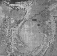
Figure 1 Picture of the deadly cyclone of 29 April, 1991.
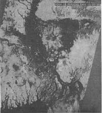
Figure 2 Flooded area shown in the NOAA-10 imagery taken at SPARRSO on 15.9.88.