| GISdevelopment.net ---> AARS ---> ACRS 1994 ---> Disasters |
Soil Erosion Mapping with
Universal Soil Loss equation and GIS
C.Mongkolsawat, P. Thirangoon,S. Sriwongsa
Computer Centre, Kho Kaen University, Khon Kaen 4002, Thailand
C.Mongkolsawat, P. Thirangoon,S. Sriwongsa
Computer Centre, Kho Kaen University, Khon Kaen 4002, Thailand
Abstract
The purpose of this study is to establish spatial information of soil erosion using the Universal Soil Loss Equation (USLE) and GIS. The study area, Huai Sua Ten watersheds, covers an area of approximately 41 thousand hectares and located in Khon Kean and Udon Thani provinces, Northeast Thailand. Landscape of the study area is gently undulating with sparse dipterocarp tress and isolated patches of forest remnants.
A set of factors as identified in the USLE were studied and reviewed. These include rainfall erosivity factor (R-factor), soil erodibility factor (K-factor), slope and slope length factor (LS-factor), and vegetative cover factor (C-factor) and conservation practice factor (P-factor). Each factor which consists of a set of logically related geographic features and attributes is used as data input for analysis. The factor layers were collected from existing information and extracted from Landsat MT imagery.
Analysis of daily rainfall data of past 11 years gives the R-factor. Spatial K-factor was formulated from detailed reconnaissance soil ma of the Land Development Department (LDD) of Thailand. Digital elevation model (DEM), interpolated from elevation contours, was employed to generate the slope and LS-factor. Spatial vegetative cover, extracted from Landsat TM imagery, was used to determine the spatial C-factor and consequently P-factor, values of which are based on experimental results.
Each of the above mentioned USLE factors, with associated attribute data, was digitally encoded in a GIS database to eventually create five thematic layers. Simultaneous overlay operation on these five layers produces a resultant polygonal layer, each polygon of which is a homogeneous area with respect to each of the five factors.
USLE model calculation applied to the resultant polygonal layer gave values of soil loss in tons/ha/year. These are then aggregated into 8 classes of 0-10, 10-20, 20-30, 30-40, 40-50, 50-100, 100-150 and > 150 tons/ha/year. The study indicates that low erosion classes are located in areas of land is used for field where slope gradient is very low. High erosion classes concentrate in areas where land is used for field crops with no conservation practice.
To evaluate its reliability, the resultant soil erosion map, produced using GIS, was checked against existing soil erosion maps and data of field surveys. It was found to be satisfactory. This study confirms that the use of GIC and remotely sensed data can greatly enhance spatial modelling of soil erosion.
1. Introduction
For the past two decades, encroachment of agricultural activities on forest reserves has become an acute problem in Thailand. Not only does encroachment account for forest loss, but soil fertility depletion as well. Official report shows an annual encroachment rate of 4564 sq.kms. for the period 1961-1991. (Charuppat, 1992). This corresponds to a 53 percent reduction of forestland for the same period. As a result, the 1991 statistics shows only 26 percent of the country is forestland (Charuppat, 1992). Clearing of forests has had serious consequences on surface water hydrology and accelerated the processes of soil erosion, particularly on steeply sloping land. According to the Land Development Department (LDD), about 17 million sq. kms., or one third of the country, is subject to moderate to severe erosion hazards. (Omakupt, 1991).
For years, LDD has been using the Universal Soil Loss Equation (USLE) to predict soil losses based only on field experiments on a number of landaus patterns. No information on spatially distributed soil erosion rate is provided.
It was only recently that an effort to map soil erosion distribution in the Northeast of Thailand was introduced, with the establishment of a manual method by LDD (Wichaidit et al 1992). Given the limited capacity of the manual method, there is a growing need to systematically map soil erosion, using GIS and related technologies for speed and accuracy.
The objectives of this study are:-
The study area is the Huai Sua Ten watersheds, as area of about 41,080 ha. It is located in the Northeast of Thailand, covering part of Khon Kaen and Udon Thani provinces.
Geologically, the area is underlain by a thick sequence of Mesozoic rock of the Maha Sarakam Formation. This formation was deeply weathered in the Tertiary period. It contains sandstone's, silstones and sandy shells with interbeded evaporites. The landscape is gently undulating with sparse trees, and is of about 180-200 m. above mean sea level. Annual rainfall averages 1200 m.m.
Rice is grown in the depression and field crops, mainly cassava and sugar cane, are restricted to the upland. Isolated forest remnants typify the remaining forests in the area. Soil is inherently low in fertility and have sandy texture, with low cation exchange capacity.
3. Methodology
Soil loss assessment for the Hua Sua Ten Watershed is based on the USLE, with procedures as provided in the USDA Handbook No. 537. (Wiscmeir et al 1978) The USLE is defined as follows.
A=RKLSCP (tons/ha/year) Where
A= soil loss
R= rainfall erosivit factor
K= soil erodibility factor
LS = slope and slope length factor
C= vegetative cover factor
P= conservation practice factor
This equation was designed for soil erosioin prediction based on empirical research and statistical analysis of field experiments. Each factor is considered as a thematic layer in the GIS. Determinations of the various factors are described below.
a) R-factor layer.
Rainfall data of 11 years (1979-1990) recorded by the Meteorological Department was used for calculation. R factor is the summation of daily erosive factor (y).
Where in (y) = 3.2353+1.7890 In (x)…. (Wanapiyarat et al 1986), X= Daily rainfall data.
The R-factor value for the entire of the Haui Sua Ten Watershed was determined to be 621.51.
b) K-factor layer.
The k-factor was generated from detailed-reconnaissance soils map (1:100,000) and assigned values according to soil textue as studied by the LDD (LDD, 1983).
c) LS- factor layer.
An areal unit for which determination of slope and its corresponding slope length is based on, is identified by slope and aspect classes. Slope and aspect map layers are, generated from digital elevation model. These are, in turn, generated from elevation contours of topographic maps at 1:50,000 scale. Overaly operation on the slope and aspect layers yields a polygonal layer, each ploygon of which is an area unit used for determination of slope length. The LS-factor layer is then generated from the following equation:
LS = (L/22.1)" (0.065 + 0.04SS + 0.0065S2), (Wischemeir
et al 1978)
Where m = 0.5 for S> 5%
0.5 for S > 5%
0.4 for S 3-5%
0.3 for S 1-3%
0.2 for S < 1%
S= slope (%), L = slope length (m).
d) C-factor layer.
Spatial vegetative cover was extracted from Landsat TM imagery acquired in December 1990. Based on experiments conducted by Watanasak (1978), Srikhajon et al (1984), and Srikhanjon (1988), values for the various vegetative cover types (C-factor) are assigned accordingly.
e) P-factor layer.
The P-factor was determined to be 0.027 for paddy field. For all other vegetative cover types, no erosion control was found, and are assigned the value 1. The values assigned were based on the study conducted by Omakupt (1989).
Attribute values of the factor layers are summerized in table 1.
Table 1 Attribute values of the factor layers
Each of the USLE factors with associated attribute data are digitally encoded in a GIS database to eventually produce five thematic layers. These are then spatially overlaid to produce a resultant polygonal layer. Application of the USLE model to the resultant layer yields a soil erosion map with 8 classes of soil loss. Schematic chart of the spatial overlay showing spatial data and associated attribute data is illustrated in figure 1.
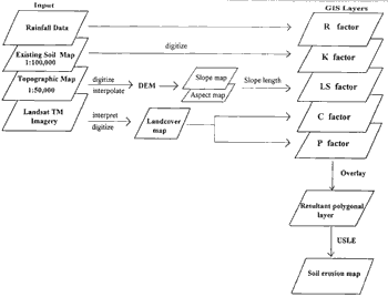
Figure 1 Schematic chart of GIS applications to soil erosion mapping
4. Results and discussions
The soil erosion map resulting from the spatial overlay of USLE factors in the Huai Sua Ten Watershed is presented in figure 2. Table 2 presents corresponding quantitative soil loss, in addition to the spatial information.
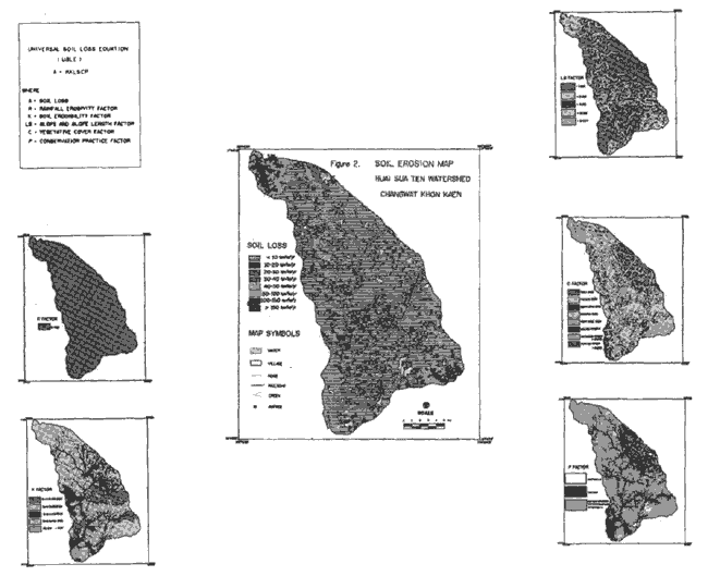
Figure 2 Soil Erosion Map Huai Sua Ten Watershed Changwat Khon Kaen
Table 2 Soil Loss in the Huai Sua Ten Watershed
The study provides overall insight into causes of soil erosion esulting from interaction of the USLE factors spatially and quantitatively. It is evident from the stud that severe soil loss covers an area of only about 5.5% for which the total soil loss exceeds 50% of the watershed area. The study of soil loss should, therefore, be conducted in terms of quantity and extent. It has became increasingly apparent that computer based GIS and remote sensing can provide the means to model soil erosion effectively.
Result of this study gives an erosion range of 59-153 tons/ha/yr. As compared to 31-125 tons/ha/ya reported by Wichaidit (Wichaidit et al 1992), also uisng USLE model. Variation in the results is due apparently to variations in the values of each of the factors used. In particular, the slope classes and the C-factor. For more comparable results, decisioins regarding reasonable factor values must be made. This will require further empirical research to determine these values.
In conclusion, the potential soure of prediction error is in selecting factor values. It is possible to spatially and quantitatively anlyse multi-layer of data within a wateshed using GIS. Using GIS technlogy in combination with remote sensing can provide systematic sata in dynamic manner for decision-support system.
5. References
The purpose of this study is to establish spatial information of soil erosion using the Universal Soil Loss Equation (USLE) and GIS. The study area, Huai Sua Ten watersheds, covers an area of approximately 41 thousand hectares and located in Khon Kean and Udon Thani provinces, Northeast Thailand. Landscape of the study area is gently undulating with sparse dipterocarp tress and isolated patches of forest remnants.
A set of factors as identified in the USLE were studied and reviewed. These include rainfall erosivity factor (R-factor), soil erodibility factor (K-factor), slope and slope length factor (LS-factor), and vegetative cover factor (C-factor) and conservation practice factor (P-factor). Each factor which consists of a set of logically related geographic features and attributes is used as data input for analysis. The factor layers were collected from existing information and extracted from Landsat MT imagery.
Analysis of daily rainfall data of past 11 years gives the R-factor. Spatial K-factor was formulated from detailed reconnaissance soil ma of the Land Development Department (LDD) of Thailand. Digital elevation model (DEM), interpolated from elevation contours, was employed to generate the slope and LS-factor. Spatial vegetative cover, extracted from Landsat TM imagery, was used to determine the spatial C-factor and consequently P-factor, values of which are based on experimental results.
Each of the above mentioned USLE factors, with associated attribute data, was digitally encoded in a GIS database to eventually create five thematic layers. Simultaneous overlay operation on these five layers produces a resultant polygonal layer, each polygon of which is a homogeneous area with respect to each of the five factors.
USLE model calculation applied to the resultant polygonal layer gave values of soil loss in tons/ha/year. These are then aggregated into 8 classes of 0-10, 10-20, 20-30, 30-40, 40-50, 50-100, 100-150 and > 150 tons/ha/year. The study indicates that low erosion classes are located in areas of land is used for field where slope gradient is very low. High erosion classes concentrate in areas where land is used for field crops with no conservation practice.
To evaluate its reliability, the resultant soil erosion map, produced using GIS, was checked against existing soil erosion maps and data of field surveys. It was found to be satisfactory. This study confirms that the use of GIC and remotely sensed data can greatly enhance spatial modelling of soil erosion.
1. Introduction
For the past two decades, encroachment of agricultural activities on forest reserves has become an acute problem in Thailand. Not only does encroachment account for forest loss, but soil fertility depletion as well. Official report shows an annual encroachment rate of 4564 sq.kms. for the period 1961-1991. (Charuppat, 1992). This corresponds to a 53 percent reduction of forestland for the same period. As a result, the 1991 statistics shows only 26 percent of the country is forestland (Charuppat, 1992). Clearing of forests has had serious consequences on surface water hydrology and accelerated the processes of soil erosion, particularly on steeply sloping land. According to the Land Development Department (LDD), about 17 million sq. kms., or one third of the country, is subject to moderate to severe erosion hazards. (Omakupt, 1991).
For years, LDD has been using the Universal Soil Loss Equation (USLE) to predict soil losses based only on field experiments on a number of landaus patterns. No information on spatially distributed soil erosion rate is provided.
It was only recently that an effort to map soil erosion distribution in the Northeast of Thailand was introduced, with the establishment of a manual method by LDD (Wichaidit et al 1992). Given the limited capacity of the manual method, there is a growing need to systematically map soil erosion, using GIS and related technologies for speed and accuracy.
The objectives of this study are:-
- to establish GIS method for spatial of soil erosion, based on the USLE.
- to evaluate the utility of GIS with regard to soil erosion mapping.
The study area is the Huai Sua Ten watersheds, as area of about 41,080 ha. It is located in the Northeast of Thailand, covering part of Khon Kaen and Udon Thani provinces.
Geologically, the area is underlain by a thick sequence of Mesozoic rock of the Maha Sarakam Formation. This formation was deeply weathered in the Tertiary period. It contains sandstone's, silstones and sandy shells with interbeded evaporites. The landscape is gently undulating with sparse trees, and is of about 180-200 m. above mean sea level. Annual rainfall averages 1200 m.m.
Rice is grown in the depression and field crops, mainly cassava and sugar cane, are restricted to the upland. Isolated forest remnants typify the remaining forests in the area. Soil is inherently low in fertility and have sandy texture, with low cation exchange capacity.
3. Methodology
Soil loss assessment for the Hua Sua Ten Watershed is based on the USLE, with procedures as provided in the USDA Handbook No. 537. (Wiscmeir et al 1978) The USLE is defined as follows.
A=RKLSCP (tons/ha/year) Where
A= soil loss
R= rainfall erosivit factor
K= soil erodibility factor
LS = slope and slope length factor
C= vegetative cover factor
P= conservation practice factor
This equation was designed for soil erosioin prediction based on empirical research and statistical analysis of field experiments. Each factor is considered as a thematic layer in the GIS. Determinations of the various factors are described below.
a) R-factor layer.
Rainfall data of 11 years (1979-1990) recorded by the Meteorological Department was used for calculation. R factor is the summation of daily erosive factor (y).
Where in (y) = 3.2353+1.7890 In (x)…. (Wanapiyarat et al 1986), X= Daily rainfall data.
The R-factor value for the entire of the Haui Sua Ten Watershed was determined to be 621.51.
b) K-factor layer.
The k-factor was generated from detailed-reconnaissance soils map (1:100,000) and assigned values according to soil textue as studied by the LDD (LDD, 1983).
c) LS- factor layer.
An areal unit for which determination of slope and its corresponding slope length is based on, is identified by slope and aspect classes. Slope and aspect map layers are, generated from digital elevation model. These are, in turn, generated from elevation contours of topographic maps at 1:50,000 scale. Overaly operation on the slope and aspect layers yields a polygonal layer, each ploygon of which is an area unit used for determination of slope length. The LS-factor layer is then generated from the following equation:
Where m = 0.5 for S> 5%
0.5 for S > 5%
0.4 for S 3-5%
0.3 for S 1-3%
0.2 for S < 1%
S= slope (%), L = slope length (m).
d) C-factor layer.
Spatial vegetative cover was extracted from Landsat TM imagery acquired in December 1990. Based on experiments conducted by Watanasak (1978), Srikhajon et al (1984), and Srikhanjon (1988), values for the various vegetative cover types (C-factor) are assigned accordingly.
e) P-factor layer.
The P-factor was determined to be 0.027 for paddy field. For all other vegetative cover types, no erosion control was found, and are assigned the value 1. The values assigned were based on the study conducted by Omakupt (1989).
Attribute values of the factor layers are summerized in table 1.
| R-factor | K-factor | LS-factor | C-factor | P-factor | |
| % slope | LS-factor | ||||
| 621.54 | Sic = 0.27 | 0 - 2 | 0.255 | R = 0.28 | R = 0.0027 |
| SL (low) = 0.26 | 2 - 7 | 1.087 | C = 0.60 | C = 1 | |
| SL (up) = 0.29 | 7 - 12 | 3.603 | S = 0.45 | S = 1 | |
| LS (low = 0.05 | 12-18 | 7.878 | P = 0.02 | P = 1 | |
| LS (up) = 0.04 | 18-24 | 12.852 | T = 0.30 | T= 1 | |
| > 24 | 24.074 | F1 = 0.048 | F1 = 1 | ||
| F2 = 0.088 | V = 0 | ||||
| V = 0 | V = 0 | ||||
| W = 0 | W = 0 | ||||
| 1) Sic = Silty clay ; SL =
Sandy Loam ; LS = Loamy Sand 2) R = Rice; C = Cassava ; S = Sugar cane ; P = Pasture T = Fruit tree ; F1 = deciduous forest ; F2 = Planted forest V = Village; W = Water body | |||||
Each of the USLE factors with associated attribute data are digitally encoded in a GIS database to eventually produce five thematic layers. These are then spatially overlaid to produce a resultant polygonal layer. Application of the USLE model to the resultant layer yields a soil erosion map with 8 classes of soil loss. Schematic chart of the spatial overlay showing spatial data and associated attribute data is illustrated in figure 1.
Figure 1 Schematic chart of GIS applications to soil erosion mapping
4. Results and discussions
The soil erosion map resulting from the spatial overlay of USLE factors in the Huai Sua Ten Watershed is presented in figure 2. Table 2 presents corresponding quantitative soil loss, in addition to the spatial information.
Figure 2 Soil Erosion Map Huai Sua Ten Watershed Changwat Khon Kaen
| Class | Rate | Area | % | Soil loss | % |
| 1 | 10 | 30,266.50 | 73.67 | 44,412.46 | 6.68 |
| 2 | 10-20 | 1,419.75 | 3.45 | 22,882.88 | 3.45 |
| 3 | 20-30 | 4,902.50 | 11.93 | 127,809.12 | 19.23 |
| 4 | 30-40 | 666.50 | 1.62 | 20,774.90 | 3.13 |
| 5 | 40-50 | --- | --- | --- | --- |
| 6 | 50-100 | 1,531.50 | 3.72 | 109,038.96 | 16.39 |
| 7 | 100-150 | 1,753.00 | 4.26 | 201,093.90 | 30.24 |
| 8 | > 150 | 540.50 | 1.31 | 138,862.55 | 20.88 |
| Total | 41,080.25 | 100 | 664,874.77 | 100 |
The study provides overall insight into causes of soil erosion esulting from interaction of the USLE factors spatially and quantitatively. It is evident from the stud that severe soil loss covers an area of only about 5.5% for which the total soil loss exceeds 50% of the watershed area. The study of soil loss should, therefore, be conducted in terms of quantity and extent. It has became increasingly apparent that computer based GIS and remote sensing can provide the means to model soil erosion effectively.
Result of this study gives an erosion range of 59-153 tons/ha/yr. As compared to 31-125 tons/ha/ya reported by Wichaidit (Wichaidit et al 1992), also uisng USLE model. Variation in the results is due apparently to variations in the values of each of the factors used. In particular, the slope classes and the C-factor. For more comparable results, decisioins regarding reasonable factor values must be made. This will require further empirical research to determine these values.
In conclusion, the potential soure of prediction error is in selecting factor values. It is possible to spatially and quantitatively anlyse multi-layer of data within a wateshed using GIS. Using GIS technlogy in combination with remote sensing can provide systematic sata in dynamic manner for decision-support system.
5. References
- Charuppat, T. 1992. Analysis of Forest Situation in Thailand from Landsat Imagery. Royal Forest Department 81 pp.
- Land Development Departmetn. 1973. Detailed Reconnaissance soil map of Khon Kaen, Udon Thani Province 1:100,000 scale. Survey Division. Bangkok.
- Land Development Departmetn, 1983. Soil Erosion in Thailand. Land Development Departemtn, Ministry of Agriculture and cooperatives.
- Omakupt, M. 1989. Soil Erosioin Mapping Using Remote Sensing Data and GIS.
- Proceedings of the 10th ACRS Nov. 23-29, 1989. Kuala Lumpur, Malaysia.
- Omakupt, W. and Sawattanakoon S. 1986. Evaluation of C-factor (Kenaf) in the Universal Soil Loss Equation Seminar on Research and Technolog Development LDD.
- Watanasak, M. 1978. A Preliminary study on the Evaluation of soil Erosion Study on the Evaluation of soil Erosion Status using USLE and Landsat Imagery Techniqus in Chonburi and Rayong Provinces, M.Sc Thesis Mahidol University.
- Wichaidit, P. and Prmajanee, P. 1992. The Survey Study and Mappng of Soil Erosion in Khon Kean In Workshop on Reserch and Agricultrual Development in Northeast Thailand, Agricultural Development Research Center, Khon Daen.
- Wischmeir, W.H. and Smith, D.D. 1978. Predicting Rainfall Erosion Losses. A Guide to Conservation planing. USDA Agric. Handboo No. 537.
- Srikhajon, M., Somarang, A., Promojanee, S., Pradabwite and Aneckasampthant, C., 1984. Application of the Universal Soil Loss Equation for Thailand. The 5th ASEAN Soil Conference, Bangkok 10-23 June, 1984.
- Srikhajon, M. 1988. Direction of the Study on Soil Erosion and Soil Conservation Lecture Note for the ITC-LDD Training Course on the Application of Aerial Photography in soil survey, Bangkok Thailand.