| GISdevelopment.net ---> AARS ---> ACRS 1994 ---> Agriculture / Soil |
Investigation on the upgrade
of landuse in irrigation project area using satellite image data in
Thailand
Kiyoshi Torli*, Tomoyuki Mase*, Masami Iwasaki**Takashi Hosh***, Prasert Millintangul*** and Prapant Svetanant****
*Dept. of Agric Eng. Kyoto Univ. Kyoto, Japan 606-1
**Dept. of Agric. Eng. Tottori University, Torroti, Japan 680-00
***Dept. of Comp. & Inform. Sci., Ibaragi University, Mito, Japan 316-00
****Hydrology Division, R.I.D Ministry of Agriculture, Bangkok, Thailand 10300
*****Faculty of Economics, Chulalongkorn University, Bangkok, Thailand 100500
Abstract
In the big irrigation project area which implemented by Thai government for long time in the vicinity of Bangkok Metropolis, a large scale of Industrial estates and residential land were constructed, and expanding their area rapidly.
About landuse in agricultural side, intensive agriculture for example orchard, fruit plant, vegetable farm, fish ponds became to be observed instead of former paddy rice field. We would like to discuss the upgrade of landuse in the irrigation project area using satellite image and by field survey in the point of water management system in Rangsit project in Thailand.
1. Introduction
Outskirts of Bangkok, Thailand is being developed rapidly now and a sudden change in land use of this area is occurring. This change seems to center around Rangsit irrigation area extending in the east side of the central Chaophraya plain. In view of in landuse change in the aspect of agriculture, rice growing in the dry season has been introduced to the single corp paddy rice in the rainy season and, further, transfiguration to more profitable agriculture such as vegetable and fruit cultivation has been accomplished. In search of profit efficiency, fish ponds in inland and shrimp farms in coastal area have also become popular. A stable supply and enlarged volume of irrigation water including water supplied by Rangsit irrigation project seem to e the explosive power for upgrading of landuse. When we consider agricultural and social developments in developing countries in future, it is highly imaginable that this area in Thailand will be a model for developmental process. In the present study, we analyze the state of upgrading of landuse of Rangsit area and Sait Prakah district located downstream using satellite image data by field survey to assess the agricultural water management system comprehensively.
2. Development process in Ransit area
Rangsit Irrigation Project area in the northeast of Bangkok is about 200,000 ha and it is most deltts-like area among chaophraya delts. Its 80% is between 1.5 and 2.5m above sea level and the whole area is extremely flat.
This area used to be in the state of flood in the rainy season due to rainfall and inflow of water from the surrounding areas. In the dry season, the whole surface was dried up transfiguring into the earth spreading with cracks. In other words, this area presented the sight of a gigantic lake with the show surface under water in the rainy season and the sight clay desert being dried up in the dry season and these scenes were repeated over and over in the half year cycles.
Today, the area has been turned into an extremely artificial space with highly dense canal networks. These canals were excavated in 1880s by siam canal arrangement of the canals consists of about 20 straight canals of 20-30 km lengths running from south to north at about 2-km intervals. Apart from these, some canals were constructed from east to west crossing perpendicularly to the previous ones. By the combination of these canals, this area is covered by a complete canal network.
The space with a half year cycle of complete submerging and complete drying in Rangsit area, which is typical of a monsoon delta, was extremely unfit for human living. When the whole 200,000 ha land of Rangsit sank under water, it must have been difficult to make a living space for men there. On the other hand, in the state of dry season, it must have been more unfit as it was impossible to ensure drinking was when the whole 200,000 ha area was cracked and became a dry clay board without a river in Rangsit area was a space refusing human survival.
Excavation of canal networks was the most effective means of improving environment of severe nature such as this. The canals with sufficient depth should have enough water even in the dry season. Living water can be secured with this, and construction of dikes with the dug earth should provide high places for residential area which is not flooded during the rainy season. Development of Rangsit area had been implemented using such a measure. At present, it is quire obvious at stepping into Rangsit area that all the houses were built along the canals excavated as such.
3. Water resources and upgrading of landuse
In the mid 19th century, cash crop farm became popular in the areas of tropical rain forest climate and rice demand in these areas increased rapidly. Sugarcane cultivation in Java Island and cultivation of rubber in Malay peninsula were started in the end of 19th century and expanded their cultivation areas in the early 20th century. Corresponding to these trends, paddy field in Rangsit area gradually expanded to supply rice t these areas as food and rapidly popularized between the late 19th to the early 20th centuries when canals were excavated for rice transportation and living.
As a result, export of Thai rice was increased and the country grew into the largest rice export country from the end of the Second World War to 1960s. Chaophraya delta was called the rice bowl of the world. As long as rice was the only and profitable product of the delta, all the construction works were carried out for building irrigation and drainage facilities with the aim of infrastructure improvement for rice growing. History of the delta development will be given in the following.
In the coastal area along the Chaophraya east bank, National Route 3 runs 2 - 3km inside the coast and this is playing the role of preventing sea water intrusion. At the river mount, gates were installed to prevent salt water from entering inland. Thus, it is planned to store fresh water flowing from upstream Rangsit area as much as possible before escaping to the sea so that it can be utilized for paddy field and dish breeding. According to the survey by Takaya and Kaida et.al in 1979 single crop-paddy field during the rainy season occupied the majority at that time and natural khlongs from 6 to 7 -m to 30 m wide were present at about 1 km intervals and houses were standing along these khlongs with ponds dug behind the houses for water intake. Generally, the hoses were built on the ground formed by heaping the earth from digging ponds and they were surrounded by coconut palms and bamboo arranged as windbreaks.
5. Analysis of satellite images
We have examined the general trend that upgrading of landuse occurs accompanying a stable water supply and ensured water resources in Rangsit area. Here we proceed our analysis selecting 2 study areas; one is situated north of Don Muan International Airport along Rangsit canal and the other is Samut Prakan area where industrial estates are being constructed in a belt between Bangkok Pattaya highway and the coastal line.Table 1 Area of 3 industrial estates in coastal zone(ha)
6. Concluding remarks
Rangsit irrigation project area was once a typical monsoon delta. In other worlds, the ground was flooded over the whole area in the rainy season while it was dried upto the water less state in the dry season.
In such an area, stable and abundant irrigation water supply was facilitated gradually starting with construction of canal networks followed by South Pasak project, Greater Chaophraya project and construction of Phumpol and Sirikit dams. Accompanying these projects, agriculture in this area has developed to cultivation of more profitable products from single crop rice growing in the rainy season to two crop rice growing and to fruit gardens.
With upgrading of landuse, water demand has grown further. Exploit of water resources had expanded selectivity of landuse and has shown a tendency of shifting to more profitable landuse. Construction of industrial estates and population increase accompanying it resulted in further rise of water demand in rangsit, area. As present there is a plan to introduce water from Ing and Kok rivers in the basin of Mekhon river to Sirikit dam and we could like to observe Ransit area where further change is expected using satellite images.
Finally, satellite image processing in the present study was conducted under proram Developments with permission of Data Processing Center, Kyoto University, and Mos-1 image data was distributed specially for research purpose from the National space development agency of Japan. Landsat 5TM image data was supplied by the National Research Council or Thailand with special consideration. A part of this study was included in General Research (A) (Represented by Prof. Masahil Tanaka, Mie University) sponsored by the Scientific Research Fund of Ministry of Education. We express our gratitude for all who are concerned.
References
In the big irrigation project area which implemented by Thai government for long time in the vicinity of Bangkok Metropolis, a large scale of Industrial estates and residential land were constructed, and expanding their area rapidly.
About landuse in agricultural side, intensive agriculture for example orchard, fruit plant, vegetable farm, fish ponds became to be observed instead of former paddy rice field. We would like to discuss the upgrade of landuse in the irrigation project area using satellite image and by field survey in the point of water management system in Rangsit project in Thailand.
1. Introduction
Outskirts of Bangkok, Thailand is being developed rapidly now and a sudden change in land use of this area is occurring. This change seems to center around Rangsit irrigation area extending in the east side of the central Chaophraya plain. In view of in landuse change in the aspect of agriculture, rice growing in the dry season has been introduced to the single corp paddy rice in the rainy season and, further, transfiguration to more profitable agriculture such as vegetable and fruit cultivation has been accomplished. In search of profit efficiency, fish ponds in inland and shrimp farms in coastal area have also become popular. A stable supply and enlarged volume of irrigation water including water supplied by Rangsit irrigation project seem to e the explosive power for upgrading of landuse. When we consider agricultural and social developments in developing countries in future, it is highly imaginable that this area in Thailand will be a model for developmental process. In the present study, we analyze the state of upgrading of landuse of Rangsit area and Sait Prakah district located downstream using satellite image data by field survey to assess the agricultural water management system comprehensively.
2. Development process in Ransit area
Rangsit Irrigation Project area in the northeast of Bangkok is about 200,000 ha and it is most deltts-like area among chaophraya delts. Its 80% is between 1.5 and 2.5m above sea level and the whole area is extremely flat.
This area used to be in the state of flood in the rainy season due to rainfall and inflow of water from the surrounding areas. In the dry season, the whole surface was dried up transfiguring into the earth spreading with cracks. In other words, this area presented the sight of a gigantic lake with the show surface under water in the rainy season and the sight clay desert being dried up in the dry season and these scenes were repeated over and over in the half year cycles.
Today, the area has been turned into an extremely artificial space with highly dense canal networks. These canals were excavated in 1880s by siam canal arrangement of the canals consists of about 20 straight canals of 20-30 km lengths running from south to north at about 2-km intervals. Apart from these, some canals were constructed from east to west crossing perpendicularly to the previous ones. By the combination of these canals, this area is covered by a complete canal network.
The space with a half year cycle of complete submerging and complete drying in Rangsit area, which is typical of a monsoon delta, was extremely unfit for human living. When the whole 200,000 ha land of Rangsit sank under water, it must have been difficult to make a living space for men there. On the other hand, in the state of dry season, it must have been more unfit as it was impossible to ensure drinking was when the whole 200,000 ha area was cracked and became a dry clay board without a river in Rangsit area was a space refusing human survival.
Excavation of canal networks was the most effective means of improving environment of severe nature such as this. The canals with sufficient depth should have enough water even in the dry season. Living water can be secured with this, and construction of dikes with the dug earth should provide high places for residential area which is not flooded during the rainy season. Development of Rangsit area had been implemented using such a measure. At present, it is quire obvious at stepping into Rangsit area that all the houses were built along the canals excavated as such.
3. Water resources and upgrading of landuse
In the mid 19th century, cash crop farm became popular in the areas of tropical rain forest climate and rice demand in these areas increased rapidly. Sugarcane cultivation in Java Island and cultivation of rubber in Malay peninsula were started in the end of 19th century and expanded their cultivation areas in the early 20th century. Corresponding to these trends, paddy field in Rangsit area gradually expanded to supply rice t these areas as food and rapidly popularized between the late 19th to the early 20th centuries when canals were excavated for rice transportation and living.
As a result, export of Thai rice was increased and the country grew into the largest rice export country from the end of the Second World War to 1960s. Chaophraya delta was called the rice bowl of the world. As long as rice was the only and profitable product of the delta, all the construction works were carried out for building irrigation and drainage facilities with the aim of infrastructure improvement for rice growing. History of the delta development will be given in the following.
- South Pasak Project (1915-1924)
This project was planned to construct a dam in Pasak river an introducing the irrigation water into Rangsit area. As in Fig. 1 Rama VI dam of the size of 100m width and 10m depth was constructed in the middle reaches of Pasak river. Water dammed here went down about 13 km in Raphiphat main canal reaching Nong Khae located at the top of Rangsit canal network. Here, water was divided by turning to the right into Hok Was Si Bon Main Canal going west and to Branch canal 13 going south. Construction of the dam converted the canal network, the main function of which was boat transportation to Bangkok through Rangsit canal, into irrigation canal by connection to Pasak River. In other words, abundant water dammed by Rama VI dam has become distributed t the whole area of Rangsit via the main canal of Raphibhat. Taking this opportunity, new concept of providing irrigation water was added for the first time to the conventional one of canal construction for boat transportation.
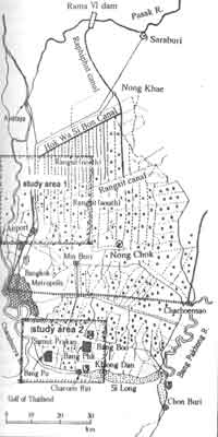
Figure 1 Rangsitand Coastal Zonein Chaophraya Plain
- Greater Chaophraya Project (1952-1957)
The main work of this project was to construct 16 sluice gates extending to the whole length of 237.5m in Chainat located at the apex of Chaophraya river at this site is 3,300 m3/s and 5 inlet gates were provided upstream. The intake fate of Chainat-Pasak canal is situated at the upper-most stream. With this main canal, distribution of water from Chaophraya river to Rangsit area has become possible passing through Rama VI dam and Rangsit area has secured a more stable water resource.
- Construction of large-scale dams
Construction of a multipurpose, large scale Phumpion dam (total storage volume : 13.5 billion m3) was started in the upstream of Chaophraya river in 1958 and completed in 1964 for augmenting the project mentioned in 2). Then construction of Sirikit dam (total storage volume: 9 billion m3) was started in 1965 and completed in 1973 for the purpose of irrigation during the dry season. With completion of these big dams, control of flood in the rainy season and increase in water supply in the dry season are facilitated bringing about the reinforcing effect on Greater Chaophraya project in 2).
- Change in cultivated products
In the early 1970s, more than 90% of the area under the present project was paddy field and its majority was practiced only in the rainy season. From late 70s to early 80s, double cropping paddy was gradually spread and, at the same time, rice acreage started to decrease. According to the survey by Kono et. al10. acreage under double cropping paddy stared to decrease in the late 80s in Rangsit North area and the acreage of paddy field is less than a half of the whole at present. The above phenomenon shows that about had of the acreage which had been paddy fields in the early 70s have turned to other landuse for the last 20 years. Former paddy fields were converted to mono-culture type of fruit gardens, residential areas and industrial area. Residential and industrial areas were gradually increased from the late 70s with the economic development of Bangkok. Fruit gardens also started to increase from the late 70s and the trend was accelerated throughout the 80s due to high profitability. However, in the late 80s, expansion speed was slightly slowed down and about 30% of the whole area remains as fruit gardens now. Recalling that the acreage under fruit cultivation was almost 0 in the early 70s, this is an astonishing change.
It is conceived that an increasing stability in irrigation water supply to this area since South Pasak Project has facilitated steady conversion to more profitable landuse.
In the coastal area along the Chaophraya east bank, National Route 3 runs 2 - 3km inside the coast and this is playing the role of preventing sea water intrusion. At the river mount, gates were installed to prevent salt water from entering inland. Thus, it is planned to store fresh water flowing from upstream Rangsit area as much as possible before escaping to the sea so that it can be utilized for paddy field and dish breeding. According to the survey by Takaya and Kaida et.al in 1979 single crop-paddy field during the rainy season occupied the majority at that time and natural khlongs from 6 to 7 -m to 30 m wide were present at about 1 km intervals and houses were standing along these khlongs with ponds dug behind the houses for water intake. Generally, the hoses were built on the ground formed by heaping the earth from digging ponds and they were surrounded by coconut palms and bamboo arranged as windbreaks.
5. Analysis of satellite images
We have examined the general trend that upgrading of landuse occurs accompanying a stable water supply and ensured water resources in Rangsit area. Here we proceed our analysis selecting 2 study areas; one is situated north of Don Muan International Airport along Rangsit canal and the other is Samut Prakan area where industrial estates are being constructed in a belt between Bangkok Pattaya highway and the coastal line.
- Rangsit canal area
Figure 2 shows the Landsat 5TM image data on served in December 1993. Rangsit canal crossing the center of the image is connected to Chaophraya river on the left and National Highway Route 1 is extending north from Don Muan International Airport. In parallel to the national highway, branches form No. 1 to No 14 of Rangsit canal are arranged at 2km intervals. According to Kono in the area of No 9 and 10 branches where water supply is guaranteed by the government, mono-culture type fruit gardens are extending. As the national highway gets closer, residential and industrial estates increase in their numbers or the grounds are unused or rice is grown while being kept for industrial or residential uses. We conducted a field survey in the end of July 1994.

Figure 2 Landsat 5 TM image of study area 1 (data aqitionon Dec. 25, 1993)
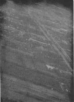
Figure 3 Photo of Rangsit canel close to Route No.1
- Samut Prakan Area
Figs. 4, 5 and 6show SPOT XS, MOS-1 and Landsat 5 TM images, respectively. We also conducted the field survey in the end of July 1994 in the areas along National Highway Route 3 and from highway 34 to Bah phil and Theparak industrial estates.
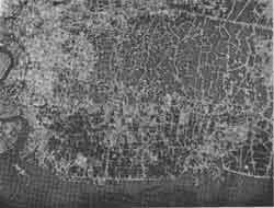
Figure 4 Spot XS Image of study area 2(Dec.22 1986)
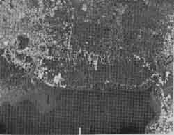
Figure 5 MOS-1 Image of Study area (Dec. 8 1989)
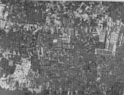
Figure 6 Landsat 5 TM Image of study area 2 (Dec. 25 1993)
Prawan cultivation ponds have spread on the south side of National Highway Route 3 but the cultivation project is interrupted as many traders have moved to other places disposing land due to pollution of pond water, occurrence of plagues and rise in land prices.
In this study area, we should pay our attentions to industrial estate. It can be confirmed from the satellite images that Bang Phil has gradually expanded its area as well as increasing in the number of buildings inside the estate. Neighboring Theparak is observable in the image taken in December 1989 and it could be inferred from the landsat TM image in December 1993 that buildings were spread out in the whole estate.
Fig.7 shows the photograph inside Theparak industrial estate. Table 1 shows the area of 3 industrial estates within the study area. In Bang Pu, too expansion of buildings over the whole estate can be confirmed. What is outstanding here are the groups of buildings on both sides of highway 34 and on both sides of the road on the south of the highway adjacent to Bang Phil industrial estate.
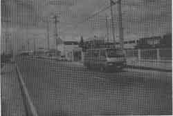
Figure 7 Photo of Teparak industrial estate (Jul.27 94)
It is imagined that these buildings are the houses of people working in the factories and the commercial zones for their living. When the development pattern of these areas is compared with the pattern in the area such as Rangsit with land readjustment, we feel apprehensive in the aspect of landuse efficiency that the structure of spontaneously developed town may be hindered by some causes such as traffic system in near future.
| name | Theparak | BangPu | Bang Phli | ||
| area(ha) | 131.8 | 461.6 | 266.6 | 240 | 208 |
| Year | 1977 | 1980 | 1989 | 1990 | |
6. Concluding remarks
Rangsit irrigation project area was once a typical monsoon delta. In other worlds, the ground was flooded over the whole area in the rainy season while it was dried upto the water less state in the dry season.
In such an area, stable and abundant irrigation water supply was facilitated gradually starting with construction of canal networks followed by South Pasak project, Greater Chaophraya project and construction of Phumpol and Sirikit dams. Accompanying these projects, agriculture in this area has developed to cultivation of more profitable products from single crop rice growing in the rainy season to two crop rice growing and to fruit gardens.
With upgrading of landuse, water demand has grown further. Exploit of water resources had expanded selectivity of landuse and has shown a tendency of shifting to more profitable landuse. Construction of industrial estates and population increase accompanying it resulted in further rise of water demand in rangsit, area. As present there is a plan to introduce water from Ing and Kok rivers in the basin of Mekhon river to Sirikit dam and we could like to observe Ransit area where further change is expected using satellite images.
Finally, satellite image processing in the present study was conducted under proram Developments with permission of Data Processing Center, Kyoto University, and Mos-1 image data was distributed specially for research purpose from the National space development agency of Japan. Landsat 5TM image data was supplied by the National Research Council or Thailand with special consideration. A part of this study was included in General Research (A) (Represented by Prof. Masahil Tanaka, Mie University) sponsored by the Scientific Research Fund of Ministry of Education. We express our gratitude for all who are concerned.
References
- Yoshikazu Takaya : "Agricultural Development of a Tropical Delta 1981.5. (Soubunsha Co. Ltd.) In Japanese)
- Masahiro Nakashima : Formation and development of irrigation water management sysmte in the Thai Chaophraya Delta, Southeast Asian Studies Vol 26, No. 4 pp 454-467 1992.3. (in Japanese).
- Kyoshi Toril : Land cover change in Chaophraya coastal area using satellite image data, "J. or IJSIDRE Vol 60 No. 1, pp 31-36 1991.1 (in Japanese)
- Katsuro Shioda : "Water use in the Chao Phraya Delta, Thailand J of JISDRE, Vol 60 No 1 pp 31-35 1992.1 (in Japanese)
- Yoshihiro Kaida : Traditional technology of agricultural water management in tropical Asia: J of IJSIDRE vol 51,no. 1, pp 11-19 1983-1 (In Japanese)
- The National Research : Council of Thailand from Space 1991.4
- Prapant Svetanant & Toshiaki Hayashi : Thai economy towards the year 2000" Institute of Developmetn Economy Tokyo 1994.
- K. Torli et al. Analysis of landuse change in Bangkok coastal area using satellite image data Proc of 12th ACRS G-4-1-6 1991.10
- Kazuo Kimuria Kok-Ing-Nan water diversion project for irrigation in the Chaophraya River Vasin", JICA (Japan International Cooperation Agency) Report 1994.3 (in Japanese)
- Yasuyuki Kono : Changing features of irrigated agriculture in the Chao Phraya Delta, Thailand, int. Conf. On Environmental Sound water Resources utilization, Bangkok Thailand, 1993.11.