| GISdevelopment.net ---> AARS ---> ACRS 1994 ---> Agriculture / Soil |
GIS Based Model for
Agro-Ecological Zoning: A Case Study of Chitwan District, Nepal
Madan P. Pariyar *,
Gajendra Singh**
*Doctoral Student ,
**Professor
Agricultural and Food Engineering Program
School of Environment, Resources and Development
Asian Institute of Technology
Bangkok, Thailand
1.0 Introduction *Doctoral Student ,
**Professor
Agricultural and Food Engineering Program
School of Environment, Resources and Development
Asian Institute of Technology
Bangkok, Thailand
Agro-ecological zone is a major area of land that is relatively uniform with respect to crop production possibilities. Since climate and soils are two most important natural resources which determine the ability of agricultural land to produce crops, agro-ecological zoning encompasses the delineation of land into regions or zones that are broadly homogenous with respect to climate and soil. The methodologies developed to date for agro-ecological zoning are applicable for rainfed agriculture mainly. Irrigation resource, one of the major resource bases determining crop production largely ignored. The concept of growing period calcuated from rainfall and evapo-transpiration, has been widely used in assessment of climatic resources. But as pointed out of Aggarwal (1993), in today's agriculture, when vast areas are irrigated and multiple cropping is practiced, growing period does not adequately describe the productivity of land.
The overall objective of this research was to demonstrate a methodology for agro ecological zoning using geographic information system. The specific objectives were:
- to develop a GIS based model for agro-ecological zoning; and
- to demonstrate the application of the model with a case study in Chitwan district of Nepal.
The Chitwan district is located at South -Western corner of Narayani zone in Central Development Region of Nepal between longitudes 830 55' to 840 48' East and latitudes 270 21' to 270 46' sq. km. Physiographically, it si divided into Terai, Siwaliks and Middle Mountain Regions and Middle Mountain Regions. About three fourth of the area of the district is a vale whos lands have high agricultural potential and are relatively flat. Over 75% of the annual rainfall occurs during monsoon from June through September with average annual rainfall of 2000 mm
Forest, agricultural lands, pasture/grazing lands settlements and waste lands constitute the major land use cypes in the district. The agro climatic conditions are favourable crops, vegetables and fruits. There are three cropping seasons in a year viz. Monsoon (from June to September) winter (from October to February) and summer (from March to May). The important crops are paddy, maize and millet in monsoon, wheat lentil, potato and buckwheat in winter, and paddy and maize in summer. The cropping patterns are paddy-based in low lands and maize based in uplands.
3.0 Conceptual Framework
Agro ecological zoning includes the following:
a) Creation of a computerized inventory of land resources by bringing together two layers of information on physical environmental resources, viz climate and soil.
b) Creation of agro ecological zones based on climatic feature and soil characteristics which are note markedly influenced by changes in management (Carson 1992).
The conceptual GIS based model for agro-ecological zoning is shown in figure - 1
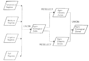
Fig 1 Conceptual GIS based model for agro-ecological zoning
4.0 Research Methodology
4.1 Creation of primary digital database
The primary databases were created by digitizing the land systems and land capability maps and scale 1:50,000. ARC/INFO version 3.4D plus was used for digitizing and geo-processing.
4.2 Creation of soil resources database.
The soil resources inventory was compiled from land systems report (LRMP, 1986). The various steps followed in the generation of the database were:
- Identification of soil mapping unit characteristics:
- Computer storage of soil data.
- Linkage of soil data to land systems database.
- Field verification of soil data.
- Creation of temperature regimes database.
4.4 Creation of moisture regimes database.
The moisture regimes database was obtained from the LANDCAP by grouping and classifying the polygons (land on their mapping units) based on their moisture related characteristics.
4.5 Creation of irrigation regimes database
Irrigation regimes database was created based on information collected from published literature (Shukla et.al. 1993, Krishi 1993, WECS 1985), data collected from various local offices; and through extensive travels across the district, irrigation potentials were determined by identifying canal irrigable, pump irrigable and non-irrigable zones.
4.6 Creation of climatic resources database.
The climatic resources database was generated by integrating temperature regimes layer 'CHITTEMP' moisture regimes layer CHITMOIS and irrigation regimes layer CHITIRIP.
4.7 Creation of and resources database.
The land resources database for the district was created by integrating the soil resources layer 'CHITSOIL' and climatic resources layer 'CHITCLIM'
4.8 Agro climatic zoning
The climatic database was derived from the land resources inventory. By combining pump irrigable and canal irrigable mapping units into a single, zone, viz irrigable zone, and classifying all non-agricultural lands as non-irrigable, the agro-climatic zones were delineated.
4.9 Agro edaphic zoning
The soil resources database was derived from the land resources inventory. Two texture classes viz I) medium texture indicating suitability for all field crops and ii) coarse texture indicating suitability for tuber and root crops were identified. Similarly two soil depth classes, viz i) deep - depth more than 50 cm indicating suitability for agricultural use, and ii) shallow - depth less than 50 cm limiting the soil suitability to forestry and grazing (Carson 1992) were considered. Soils with slope less then 300 and those with more than 300 were also differentiated assuming 300 to be the upper limit for arable agriculture (LRMP, 1986b)
4.10 Agro-ecological zoning
Agro-ecological zones database was created by integrating the agro-cilmating layer "AGROCLIM' and agro-edaphic layer 'AGROSOIL'
5.0 Results and Discussion
5.1 Dominant soils
Altogether eight different soil units, viz. eutric cambisols, haplic phaeozems, dystric cambisols, eutric fluvisols, haplic luvicols, eutric nitosols, cambric aeronosols and eutric regosols were identified as dominant soils. The inventory indicates that the first three soul units occupy almost 85% of the area.
5.2 Dominant soil texture
Soils were mainly medium texture in also 34% of the area. The presence of loamy texture indicates a general suitability for all field corps.
5.3 Dominant soil depth
Four different dominant soil depths:" deep, moderately deep, shallow and extremely shallow, were identified. About 49% of the area had deep soils. This indicates that the soil depth is favourable for cultivation.
5.4 Temperature regimes
Two different temperature regimes, viz sub-tropical and warm temperature with spatial coverage of 200, 720 and 18, 820 ha respectively were identified. The indicates that the region is suitable for all field crops and two crops of the rice can be grown in a year. The warm temperate regime indicates that all field crops can be grown and one crop of rice is possible in a year.
5.5 Moisture regimes
Two different moisture regimes, viz. Humid and sub-humid with spatial coverage of 204, 150 had and 15, 390 has respectively were identified. The humid moisture regime indicates that two rainfed crops with reasonable yield can be expected. The sub humid moisture regime indicates that irrigation will permit dry season cropping and will improve the yields of monsoon crops.
5.6 Irrigation regimes
The study shows that out of the total cultivated land, 29, 310 ha are canal irrigable and 9600 ha are pump irrigable.
5.7 Land resources database
The integration of soil resources layer and climatic resources layer generated a land resources database. A total of 2,453 agro ecological cells were created. Each of these polygons contains information on soils temperature, moisture and irrigation regimes.
5.8 Agro - climatic zones
Four different agro-climatic zones were delineated. Table 1 gives the spatial extent of various agro-climatic zones.
Agreo-edaphic zones
Four different soil zones were delineated. The spatial extent of various edaphic zones are given in Table 2
5.10 Agro-ecological zones
seven different agro-ecological zones were delineated. The spatial distribution of these zones is show in figure 2. The spatial show in figure 2. The spatial extent of the agro-ecological zones are given in table 2. Zones I to V are identified as arable zones with decreasing level of potential for agricultural development. The arable land area in the district can be as much as 187,640 ha. Agro-ecological zone I is the most potential zone for crop production with possibility of three crops a year. It occupies 38,190 ha of arable land. Zone II is the second important zone with potentials for two crops a year. It occupies 59,660 ha of the arable area. Zone VI is non-arable zone and has potentials for grazing and forestry uses; while zone VII, classifieds as river bed, has very limited potential for vegetation and bio-mass production.
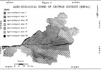
Fig 2 Agro-Ecological Zones of Chitwan District (Nepal)
SUMMARY
Agro-ecological zones (AEZ) studies carried out in the past mainly dealt with rainfed agriculture. Irrigation resource so far remained largely ignored in these studies. A GIS based model for agro-ecological zoning was developed using soil resources, temperature, moisture and irrigation regimes a input layers for geo-processing. The application of the model was demonstrated with a case study of Chitwan district in Nepal. Land systems and land capability maps were digitized. Soil resources inventory was compiled from land systems report. Temperature and moisture regime databases were derived from land capability layer. Irrigation regime database was generated based on field survey and available statistical information. A land resources database of the study area was created. Altogether 2,453 agro-ecological cells were generated. Agro-edaphic and agro-climatic zones were delineated. Agro-ecological zones database was generated; and agro-ecological zones map was produced . The AEZ map delineated as arable zones with decreasing level of potential for agricultural development, constitutes 85% of the study area. Zone I, identified as the most potential zone for crop production with possibility of three corps a year occupies 21% of the arable area; while zone II, identified as the second important zone with potentials for two crops a year, covers 32% of the arable area.
References
- Aggarwal, P.K (1993) : Agro-ecological zoning using crop growth simulation models : characterization of wheat environments of India - in systems approaches for Agricultural Development (editors : Vries, F.P.D., Teng, P and K Metsalar), Kluwer Academic publishers, London.
- Carson , B (1992) The land, The farmer, and The future, A soil fertility management strategy for Nepal, ICIMOD Occasional paper no. 21 ICIMOD, Kathmandu, Nepal.
- Krishi (1993) : "Krishi Vikas Lp Ek Jhalak" - in Nepali (A Glimpse of Agricultural development), District Agricultural Development Office, Bharatpir, Chitwan Nepal.
- LRMP (1986a) : Land systems Report, The Soil Landscape of Nepal, Land Resources Mapping Project. Kenting Earth Sciences Limited Ottwa, Canada.
- LRMP (1986b) Land capability report, Land Resources Mapping Project, Kenting Earth Sciences Limited, Ottawa, Canada.
- Shukla, A.K Gajrel, K P; Shivakoti, G., Paudel, R.; Pandir, K.N; Adhikari, K.R Thapa T,B., Shakya, S.M; Yadav D.N Joshi, N.RE and A.P. Shrestha (1993): Irrigation Resources inventory of Eat Chitwan, IMSSG, IAAS, Chitwan, Nepal.
- WECS (1985) : Water use inventory study of Chitwan District water and energy commission, Kathmandu, Nepal.