| GISdevelopment.net ---> AARS ---> ACRS 1994 ---> Agriculture / Soil |
Agriculture Applications Of
Remote Sensing : Paddy Yield Estiamtion form Landsta-5 Thematic Mapper
Data
Dr. Mohd Ibrahim Seeni Mohd
, Samsudin Ahmad, Adeli Abdullah
Centre for Remote Sensing
Faculty of Surveying and Real Estate
University Technology Malaysia
Locked Bat 791
80990 Johor Bahru, Malaysia
Abstract Centre for Remote Sensing
Faculty of Surveying and Real Estate
University Technology Malaysia
Locked Bat 791
80990 Johor Bahru, Malaysia
Satellite remote sensing techniques can provide resource managers an efficient and economical means of acquiring timely data for the development and management of our natural resources. In comparison with traditional methods, these techniques have the inherent properties of being able to provide synoptic observations with high observational density over relatively areas.
This paper reports on a study that have been carried out to estimate paddy yield from the Landsat-5 Thematic Mapper (TM) data in the Sungai Besar area in the state of Selandgor, Malaysia. In this study, two types of vegetation index (VI) have been used together with some field data to derive relationships between VI and yield, namely the Ratio Vegetation Index (RVI) and the Normalized Difference Vegetation Index (NDVI). A linear relationship has been obtained between RVI and NDVI with yield. The yield estimated derived from the satellite data have been found to be 30% higher than the field estimates. This is due to the difference in the paddy phenology cycle at the time the satellite data were acquire and the time the field measurements were taken.
1.0 Introduction
Remote sensing and its associated image analysis technology provides access to spatial information on a planetary scale. New detectors and imaging technologies are increasing the capability of remote sensing to acquire digital spatial information at very fine resolutions in an efficient manner (Ehlers et al. 1989). Up-to-date information of features and phenomena on the earth can be derived in a short duration of time.
This paer describes a study that was carried out to estimate paddy yield from vegetation indices (VIs) derives from the Landsat-5 Thematic Mapper (TM) satellite data in the Sungai Besar are in Selangor, Malaysia. In this study two types of vegetation index have been used, namely the Ratio Vegetation Index (RVI) and the Normalized Difference Vegetation Index (NDVI). Some field data that were obtained at the study area have also been used to relate paddy yield with vegetation index.
2.0 Paddy Yield Estimation
Remote sensing has potential not only in identifying crop classes but also in the estimation of crop area and yield. The examination of the relationships between vegetation indices and yield has been frequently studied over the years and has been shown the useful for yield prediction purposes. For example, Major et al (1986) have shown usefulness of some VIs to estimate some leaf area index (LAI), biomass and grain production for cereals from radiometric measurements. Tucker et al (1980) found a strong relationship between specific spectral data and yield. The resulting plots of spectral data against time give a distinctive pattern which when integrated could be related to yield. All these relationships have a high correlation with yield. In another study, Green and Invins (1985) also proved that VIs relate strongly to biomass, and have been found to relate directly to yield. Rudoff and Batista (1990) have indicated that spectral data whentransformed into VIs have great potential to be used in wheat yield prediction models tropical regions.
Since VIs have been shown to be useful for yield estimation, this study assesses two types of VIs derived from the Landsar-5 TM satellite data for estimating paddy yield in the Sungai Besar area in Selangor.
2.1 Vegetation Indices
Several empirical indices have been used as quantitative indicators of vegetation amount. They reduce the multimensional spectral space of vegetated scene to one dimension in order t sense variability in such properties as biomas, leaf area index, fractional cover and types (Jasinski 1990). In his study, two types of VIs have been used, namely the Ratio Vegetation Index (RVI) and the Normalized Difference Vegetation Index (NDVI). The RVI involves the division of two spectral bands i.e the infrared band divided by the red band. However, the RVI is affected by the 'noise' present in the image due to factors such as atmospheric conditions. The NDVI is commonly preferred because it reduces the effects of atmospheric conditions and topographical variations. The NDVI is the ratio between the difference in the infrared and red bands and the sum of bands , i.e

The infrared bands used in the study are band 4 (0.76 - 0.90mm) and band 5 (1.55 - 1.75mm) whilst the red band is 3 (0.63 - 0.69mm) of the Landsat-5 TM data.
2.2 Field Radiometric Measurements
Radiometric measurements were made at 5 sample plots each of about 2m x 2m square with a hand held radiometer with the same spectral bands as the Landsat data. The VIs were the derived from these measurements. Each plot was harvested and the Leaf Area Index (LAI) which is defined as the total leaf area per unit soil area was obtained. This was done by using a homemade leaf-area meter device which is made up of hard paper with 10cm x 10cm squares drawn on 1 m2 size. The weight of the grains were obtained by separating the grains from the paddy stalks. It was then possible to relate the LAI and grains to the VIs.
2.3 Calibration Curves
The VI values obtained from the sample plot were plotted against the grain yield. A regression fit was made to determine the relationship between yield and VIs. A linear relationship was obtained from the limited smaples that were taken. Figure 4 shows a curvilinear relationship that has been established between LAI and NDVI. The asymptote is reached at approximately 6.5 of the LAI. Above this value are almost the same regardless of increase in least per unit area. The calibration line sin figure 2 & 3 can be used t estimate paddy yield from the satellite data, the calculated VIs from the satellite data are used a input in this line.
2.4 Results and Discussions
The results show there is a linear relationship between each index and yield. The correlation coefficients obtained were 0.85, 0.55, 0.32 for NDVI, RVI (4/3) and RVI (5/3). This shows that NDVI correlates best with paddy yield as compared to other indices. This result is consistent with work done by Patel e.at (1985) who found that NDVI (4.3) have better correlation with paddy yield. Thus, the NDVI versus data have been selected for obtaining the yield estimation equation. The yield estimation equation is as follows.
YIELD (kg/ha) = 34.30 x (NDVIfield) - 237.85 (2)
The NDVI obtained from the satellite data was not similar to the NDVI in the field as given by the following relationship.
NDVIsat = NDVIfield + 0.1836 (3)
Therefore taking the above different in Eq (3) into account the yield estimation from the satellite data can be written as follows:
YIELD (kg/ha) = 34.30 x (NDVIsat - 0.1836) - 237.85 (4)
The average yield in the study are has been found to be about 6750 kg/ha by using the above techniques. However, the yield data from the Department of Agriculture indicate an approximate value of 5175 kg/ha for the same. The over-estimation in the satellite yield estimate of about 30% is due to the difference in the paddy phenology cycle at the time the satellite data were acquired (less matured) and the time the field measurements were taken (matured). Better accuracy could be obtained if the dates of the satellite data and the field data are the same or close to one another. The number of field samples were also not sufficient to improve the results of the regression analysis.
3.0 Conclusions
The NDVI values obtained from a combination of bands 3 and 4 of the Landsat-5 TM show better correlation with yield as compared to the RVI obtained from the combination of bands 3 and 4 the combination of bands 3 and 5. This is because the effects of soil and atmosphere have been considerably reduced in the NDVI. In conclusion, the paddy yield estimates. The error in the satellite yield estimate is due to the difference in the paddy phenology cycle at the time the satellite data were acquired and the time the field measurement were taken.
This study indicates the usefulness of satellite remote sensing techniques in deriving agriculture information over large areas in a cost effective manner that can benefit related agencies.
Acknowledgement
The authors wish to tanki Azhar Hj. Salleh, former postgraduates student at the faculty of surveying and Real Estate for his contribution in the study.
References
- Ehlers M., Edward G., and Bedard Y., (1989). Integration of Remote Sensing with Geographic Information systems: A Necessary Evolution. Photogrammetric Engineering and Remote Sensing, Vol 55 No. 11
- Green C.F, and Invins J.D (1985), Time of Sowing and Yields of Winter Wheat, Journal of Agricultural Science, Cambridge.
- Jasinski M.F (1990) Sensitility of the Normalized Difference Vegetation Index to Sub-pixel Canopy Cover, Soil Albedo and Pixel Scale, Remote Sensing of Environment, 32, pp 169-187.
- Major D.G Schaalje G.B, Asrar G, and Kanemasu E.T (1986) Estimation of whole plant Biomass and Grain Yield from Spectral Reflectance of Cereals. Canadian Journal of Remote Sensing 12(1), pp 47-54
- Patel N.K Singh, T.P. Sahai B., and Patel M.S, (1985) Spectral Responses of Rice Crop and its Relation to yield and yield Attributes. Int. Journal of Remote Sensing 6(5) pp 657-664.
- Rudorff B.F.T and Batista G.T, (1990) Spectral Response of Wheat and its Relationship to Agronomic Variable in the Tropical Region. Remoe sensing of Environment 31, pp 53-63.
- Tucker C.J, Holben B.N Elgin J.H and Murtey J.E (1980) Relation of
spectral to grain yield variation. Photogrammetric Engineering and
Remote Sensing 46(5), pp 43-66.
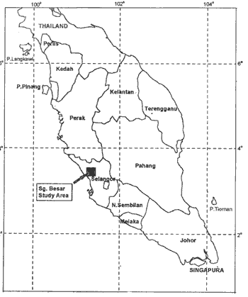
Figure 1 : Map of Study Area of Sungai Besar, Malaysia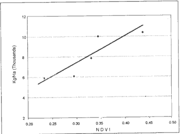
Figure 2 : Plot of Yield Versus NDVI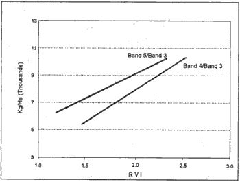
Figure 3 : Plot of Yield Versus RVI (4/3) and RVI (5/3)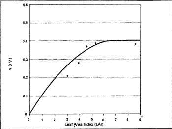
Figure 4 : Plot of NDVI Versus LAI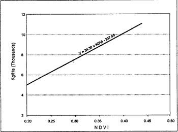
Figure 5 : Calibration Line Obtained for NDVI