| GISdevelopment.net ---> AARS ---> ACRS 1994 ---> Agriculture / Soil |
Suitability of Multidate ERS
- 1 SAR Data for Crop Acreage Estimation
P. V. Narsimha Rao, K. Sreenivas, K. V. Ramana and L. Venkataratnam
Agriculture and Soils Group, NRSA
Hyderababd-500 037, India
P. V. Narsimha Rao, K. Sreenivas, K. V. Ramana and L. Venkataratnam
Agriculture and Soils Group, NRSA
Hyderababd-500 037, India
Abstract
Use of remote sensing data acquired in visible and infrared wavelengths in crop studies is widely known. However, sensors operating in these wavelengths to provide clear data in the presence of clouds in general and along the coastal areas during monsoon period in particular. Microwave remote sensors such as Synthetic Aperture radar (SAR) on board ERS-1 satellite, have all weather capability and provide cloud free data. In view of this, an attempt has been made to study the suitability of multidate ERS-1 C-band SAR data alone for crop classification and acreage estimation. The radar data acquired at 35 day interval during 1992-93 rabi crop season, were geometrically corrected and filtered for speckle suppression. Then a maximum likelihood classification was carried out on multidate data sets. The classification results sow that better discrimination of classes like paddy, coconut, current and permanent fallow fields is possible with three date data set. This could due to the changes associated with various classes during the data acquisition period that aid in the discrimination of these classes. However, no clear discrimination could be observed between pulses and tobacco corps consideration of texture information, a characteristic of radar data, may improve discrimination between these crops evaluation of results obtained from single and two date data sets show poor classes. Results are discussed and compared against those obtained by IRS LISS - II data classification as well as BES statistics.
Introduction
Use of remote sensing data acquired by remote sensing satellites like IRS-1, LANDASAT and SPOT in the visible and infrared wavelengths in crop studies is widely known. However, sensors operating in these wavelength bands fail t provide clear date in the presence of clouds during monsoon season in general and along coastal areas in particular, rendering remotes sensing of crops difficult. On the other hand, microwave sensors such as Synthetic Aperture Radar (SAR) onboard ERS-1 satellite have all weather capability and provide cloudfree data. Potential of microwavedata for crop identification and acreage estimation has been one of the research topics all over the world with the launch of ERS-1 satellite with C-band SAR sensor. In view of this, an attempt has been made of study the suitability of ERS-1 SAR data acquired at 35 day interval during the 1992-93 rabi season. The main objective of the study has been to use microwave data alone for crop classification and acreage estimation and compare the results against those obtained by suing IRS LISS - II data of the same period. In the process, sparability of major classes in the study are was studies based on the measures such as Jeffries Matusita distance for multidimensional data sets and a pair of classes for single dimensional data sets.
Study Area
Study area is a part of East Godavari district in A.P. covering an area of 2.15 lakh acres and ten revenue mandals with major land use and land cover being crops like paddy, pulses (black gram and green gram), tobacco, paddy fallows and permanent fallows, orchards like cashew and mango, coconut and settlements. The study area is characterized by unirrigated red and black soils in the north and irrigated medium black sols in the south.
Groundtruth Collection and Data Processing :
Near synchronous ground truth for soil moisture, surface roughness conditions, crop parameters such crop height, density, growth stage have been collected for three ERS-1, SAR scenes acquired on 17th Dec 1992, 21st Jan 1993 and 25th February 1993. The IRS-1, LISS-II data of 2 Jan 93 was also acquired for validation of results obtained by SAR data analysis. Figure 1a shows a multidate colour composite image of SAR data and figure 1b shows standard FCC image of IRS LISS II data of the study area. The data sets were rectified for geometric distortions by registering tot eh topmap with the help of ground control point and a polynomial equation. The ten revenue mandal boundaries were digitized and overlayed on the ERS and IRS data sets. The ERS-1 SAR data were filtered for speckle as well as image texture suppression using a 5 x 5 moving window median filter. Training area were identified on the IRS 1 LISS II standard FCC image and purified. The spectral Major Classes covered have been paddy, pulses (green gram and black gram), tobacco, cashew and mango plantation, coconut and nurseries, settlements, paddy fallow and permanent fallow fields and fodder crop of subhemp, the training area statistics were used to compute Jetfried-Matusita distance (measure 1). For single dimensional data sets, seperability had been computed as difference in class means over the products of class standard deviation (measure 20. Subsequently, multidate ERS-1, SAR data and single date and multiband IRS-1 LISS II data were separately classifieds by maximum likelihood classification algorithms. Figure 2a shows classified image of the study area, generated from LISS II data and figure 2b shows the same area as classified by multidate SAR data.
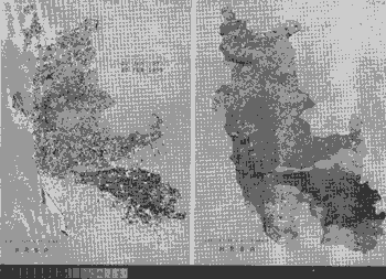
Figure 1 Multidate ERS - 1 Sar ECC image (left) and standard IRS LISS - II ECC image of 2nd Jan'93 (right)
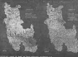
Figure 2 Classified imagery of IRS LISS - II data (left) and multidate ERS - 1 SAR data (rught)
Results and Discussion
Among the single date ERS-1 SAR data sets, data acquired 21st Jan 93 was found to have highest average seperability (S) of 0.925 (S >= 1.0, the classes are separable) compared to data acquired on 17th Dec 92 (S=0.668) and 25th Feb 93 (S = 0.666). Greater seperability in Jan 93 data set may be attributed to the maturity of crops during the mid crop season and minimal background influence. Paddy crop was seperable from other major crops like tobacco, pulses and sunhemp (with S = 1.347) but has a overlap with fallow fields with an average seperability of s = 0.438. However, separability was poor in the Jan 93 data set among tobacco pulses and sunhemp crops.
The seperability as computed by JM distance (measure 2) for three date ERS-1 SAR data showed that paddy is separable from all classes with JM distance being higher than 1292 (with upper limit being 1414). However, average seperability among crops tobacco, pulses, sunhemp and plantation was only 908 with an overlap of nearly 36%. A similar observation was made with single date, three band (band s2,3 and 4) LISS II data with the seperablity of 1140 and an overlap of 20% for these crops. A combination of LISS II bands 3 & d and ERS-1 SAR data of Jan 93 showed that overall seperability had increased to an average of 1355 with an overlap of only 5% among all classes.
Table 1 shows results of maximum likelihood classification, obtained for LISS II data set of bands 2,3 and 4 and three date ERS-1 SAR data set of Dec'92 Jan 93 and Feb 93 and BES values wherever available. It is clear from the table that identification and acreage estimation of paddy crop is possible sensor data. However it is necessary to validate these findings considering the data set acquired during kharif season. It can also be noted that fallow fields are under classified wit most of the unclassified pixels being otherwise those of fallow fields.
Table 1 Acreage of major classes in the study area as obtained
form classification of ERS-1 SAR and IRS LISS II data.
In the present study, to realize best of the classification by per classifier like maximum likelihood algorithm, the SAR data were processed for speckle and texture suppression. This might have resulted in loss of seprability to some extent in discriminating classes like fallow fields from paddy. In view of this it is felt that classification of SAR data by per pixel classifiers should follow texture segmentation for better classification accuracies.
Conclusions
In the present study attempts were focused on the use of ERS 1 data alone for crop identification and acreage estimation. Following conclusions may be drawn from the analysis of results.
Authors are grateful to Prof B.L Deeskatulu, Director, NRSA and DR. D.P. Rao, Associate Director of NRSA for their continuous support and encouragement. The authors are thankful to the Department of Space, Govt. of India for sanctioning the ongoing project under the ERS-1 RSAM-MC program.
Use of remote sensing data acquired in visible and infrared wavelengths in crop studies is widely known. However, sensors operating in these wavelengths to provide clear data in the presence of clouds in general and along the coastal areas during monsoon period in particular. Microwave remote sensors such as Synthetic Aperture radar (SAR) on board ERS-1 satellite, have all weather capability and provide cloud free data. In view of this, an attempt has been made to study the suitability of multidate ERS-1 C-band SAR data alone for crop classification and acreage estimation. The radar data acquired at 35 day interval during 1992-93 rabi crop season, were geometrically corrected and filtered for speckle suppression. Then a maximum likelihood classification was carried out on multidate data sets. The classification results sow that better discrimination of classes like paddy, coconut, current and permanent fallow fields is possible with three date data set. This could due to the changes associated with various classes during the data acquisition period that aid in the discrimination of these classes. However, no clear discrimination could be observed between pulses and tobacco corps consideration of texture information, a characteristic of radar data, may improve discrimination between these crops evaluation of results obtained from single and two date data sets show poor classes. Results are discussed and compared against those obtained by IRS LISS - II data classification as well as BES statistics.
Introduction
Use of remote sensing data acquired by remote sensing satellites like IRS-1, LANDASAT and SPOT in the visible and infrared wavelengths in crop studies is widely known. However, sensors operating in these wavelength bands fail t provide clear date in the presence of clouds during monsoon season in general and along coastal areas in particular, rendering remotes sensing of crops difficult. On the other hand, microwave sensors such as Synthetic Aperture Radar (SAR) onboard ERS-1 satellite have all weather capability and provide cloudfree data. Potential of microwavedata for crop identification and acreage estimation has been one of the research topics all over the world with the launch of ERS-1 satellite with C-band SAR sensor. In view of this, an attempt has been made of study the suitability of ERS-1 SAR data acquired at 35 day interval during the 1992-93 rabi season. The main objective of the study has been to use microwave data alone for crop classification and acreage estimation and compare the results against those obtained by suing IRS LISS - II data of the same period. In the process, sparability of major classes in the study are was studies based on the measures such as Jeffries Matusita distance for multidimensional data sets and a pair of classes for single dimensional data sets.
Study Area
Study area is a part of East Godavari district in A.P. covering an area of 2.15 lakh acres and ten revenue mandals with major land use and land cover being crops like paddy, pulses (black gram and green gram), tobacco, paddy fallows and permanent fallows, orchards like cashew and mango, coconut and settlements. The study area is characterized by unirrigated red and black soils in the north and irrigated medium black sols in the south.
Groundtruth Collection and Data Processing :
Near synchronous ground truth for soil moisture, surface roughness conditions, crop parameters such crop height, density, growth stage have been collected for three ERS-1, SAR scenes acquired on 17th Dec 1992, 21st Jan 1993 and 25th February 1993. The IRS-1, LISS-II data of 2 Jan 93 was also acquired for validation of results obtained by SAR data analysis. Figure 1a shows a multidate colour composite image of SAR data and figure 1b shows standard FCC image of IRS LISS II data of the study area. The data sets were rectified for geometric distortions by registering tot eh topmap with the help of ground control point and a polynomial equation. The ten revenue mandal boundaries were digitized and overlayed on the ERS and IRS data sets. The ERS-1 SAR data were filtered for speckle as well as image texture suppression using a 5 x 5 moving window median filter. Training area were identified on the IRS 1 LISS II standard FCC image and purified. The spectral Major Classes covered have been paddy, pulses (green gram and black gram), tobacco, cashew and mango plantation, coconut and nurseries, settlements, paddy fallow and permanent fallow fields and fodder crop of subhemp, the training area statistics were used to compute Jetfried-Matusita distance (measure 1). For single dimensional data sets, seperability had been computed as difference in class means over the products of class standard deviation (measure 20. Subsequently, multidate ERS-1, SAR data and single date and multiband IRS-1 LISS II data were separately classifieds by maximum likelihood classification algorithms. Figure 2a shows classified image of the study area, generated from LISS II data and figure 2b shows the same area as classified by multidate SAR data.
Figure 1 Multidate ERS - 1 Sar ECC image (left) and standard IRS LISS - II ECC image of 2nd Jan'93 (right)
Figure 2 Classified imagery of IRS LISS - II data (left) and multidate ERS - 1 SAR data (rught)
Results and Discussion
Among the single date ERS-1 SAR data sets, data acquired 21st Jan 93 was found to have highest average seperability (S) of 0.925 (S >= 1.0, the classes are separable) compared to data acquired on 17th Dec 92 (S=0.668) and 25th Feb 93 (S = 0.666). Greater seperability in Jan 93 data set may be attributed to the maturity of crops during the mid crop season and minimal background influence. Paddy crop was seperable from other major crops like tobacco, pulses and sunhemp (with S = 1.347) but has a overlap with fallow fields with an average seperability of s = 0.438. However, separability was poor in the Jan 93 data set among tobacco pulses and sunhemp crops.
The seperability as computed by JM distance (measure 2) for three date ERS-1 SAR data showed that paddy is separable from all classes with JM distance being higher than 1292 (with upper limit being 1414). However, average seperability among crops tobacco, pulses, sunhemp and plantation was only 908 with an overlap of nearly 36%. A similar observation was made with single date, three band (band s2,3 and 4) LISS II data with the seperablity of 1140 and an overlap of 20% for these crops. A combination of LISS II bands 3 & d and ERS-1 SAR data of Jan 93 showed that overall seperability had increased to an average of 1355 with an overlap of only 5% among all classes.
Table 1 shows results of maximum likelihood classification, obtained for LISS II data set of bands 2,3 and 4 and three date ERS-1 SAR data set of Dec'92 Jan 93 and Feb 93 and BES values wherever available. It is clear from the table that identification and acreage estimation of paddy crop is possible sensor data. However it is necessary to validate these findings considering the data set acquired during kharif season. It can also be noted that fallow fields are under classified wit most of the unclassified pixels being otherwise those of fallow fields.
| Class | Area (in acres) | ||
| IRS LISS II data | ERS - 1 SAR data | BES figures | |
| Tobacco | 41616 | 21996 | -- |
| Paddy | 42880 | 42632 | 49251 |
| Pulses | 26969 | 32419 | 74182 |
| Fallow fields | 56466 | 16315 | 65743 |
| Mixed crops (Pulses/tobacco/sunhemp | 7166 | 17732 | -- |
| Unclassified | 55798 | 96620 | -- |
In the present study, to realize best of the classification by per classifier like maximum likelihood algorithm, the SAR data were processed for speckle and texture suppression. This might have resulted in loss of seprability to some extent in discriminating classes like fallow fields from paddy. In view of this it is felt that classification of SAR data by per pixel classifiers should follow texture segmentation for better classification accuracies.
Conclusions
In the present study attempts were focused on the use of ERS 1 data alone for crop identification and acreage estimation. Following conclusions may be drawn from the analysis of results.
- Among three date ERS-1 SAR data sets used in the study, data acquired on 21st Jan 93 is observed to show maximum discrimination among various classes confirming the earlier results by visual analysis of single date data sets.
- Use of multidate ERS-1 SAR data acquired at 35 day interval during a crop season for digital classification improved classification.
- Present study showed ERS-1 SAR sensor is suitable for identification and acreage estimation of paddy crop.
- Discrimination of crops like tobacco, pulses (green and black gram) and subhemp was poor. This may be attributed to the same mean intensity associated with large standard deviation of these classes.
Authors are grateful to Prof B.L Deeskatulu, Director, NRSA and DR. D.P. Rao, Associate Director of NRSA for their continuous support and encouragement. The authors are thankful to the Department of Space, Govt. of India for sanctioning the ongoing project under the ERS-1 RSAM-MC program.