| GISdevelopment.net ---> AARS ---> ACRS 1992 ---> Poster Session R |
Colour concordance theory and
control techniques of LANDSAT image maps
Shi Junmei,Zhang
Shengkai
Institute of Remote Sensing Applications,Chinese Academy of Sciences, Beijing 100101, China
Institute of Remote Sensing Applications,Chinese Academy of Sciences, Beijing 100101, China
Abstract :
During the compilation of large-sized image maps the colour concordance theory and control techniques are studies. Firstly, main factors influencing the colour concordance of image map are analyzed, and the density measurement and control in composite processing are studied. Then the general evaluation of colour concordance is present. Finally, the control techniques are generalized.
Introduction
Since 1970s Landsat MSS images have been used for map compilation in China, experiencing for single band black-and-white mosaic to large-sized image maps. The Landsat image maps play an unique role in geoscience study since they display the natural scenes in a large scale compared with a single image scene. However, the technique are complicated to mosaics hundreds of scenes into a large – sized Landsat image map. One of the key problem is color concordance. During the last 10 years, we have compiled Landsat image maps with various regional scales, and finally the Landsat image map of China. Colour concordance theory and control techniques are studied during the compilation and positive results have been achieved.
Color concordance theory and maine effect factors
1 Environmental Factor
The objective of Remote Sensing is the ground surface, which is a multi-factor, dynamic physical geographic and environmental system. The spectral characteristics of objectives will changes due to not only spatial but also temporal varieties. These changes will be recorded as film’s density, resulting in different tones on the colour composite as shown in Table 1.
2 Relations among Film Density, Special Reflectance (p) and Exposure (t).
In colour composite process black-and-white transparent films of black-and-white transparent films of each band are put into the optical path, and the receptor is colour print.
| Path
No. 158-30 |
Imaging date | Colour Density |
Farmland | Grassland | Forest | Gobi | Snow | Rock |
| Aug. 13, 1978 | Yellow Magnetic Cyanic |
0.11 0.37 1.25 |
0.13 0.38 1.25 |
0.12 0.38 1.29 |
1.42 1.44 1.43 |
0.76 0.85 0.42 |
0.04 0.42 0.67 | |
| Sep. 22, 1972 | Yellow Magnetic2 Cyanic |
0.37 0.67 0.95 |
0.31 0.63 0.84 |
0.19 0.44 0.90 |
1.25 0.94 0.17 |
0.80 0.94 0.75 |
0.06 0.05 0.20 | |
| Oct.16, 1976 | Yellow Magnetic Cyanic |
0.64 0.97 1.11 |
0.45 0.7821.01 |
0.12 0.49 0.98 |
1.39 1.45 1.43 |
1.24 1.21 1.14 |
0.05 0.14 0.08 |
The modulation of transparent film in a colour print system is called print density. There are 3 print densities of colour print, acting on red----, green---- and blue--- sensitive layers, respectively. Since primary filters are used in color composite process, the balance of three layers are adjusted by exposure time, which is different form color print using complementry filters. The characteristic relation between print using complementry filters. The characteristic relations between pring density and exposure time are shown as below:
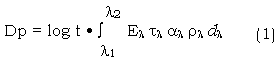
Where El is the spectral radiancy of light source:
tl is the spectral transparency of filters;
al is the spectral transparency of optical projection system
rl is film transparency of each spectral band.
In a given composite system, El, tl and al is taken as a constant K. Equation (1) is then simplified as :
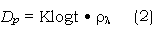
This means that the density (Dp) of each layer of colour print is correlated with the film transparency and exposure time. the former is the intrinsic factor of tone variety, while the latter is a means for colour concordance in colour composite process.
3 General Evaluation of Colour concordance
The varieties of objectives on a colour composite are displayed by means of their hue, intensity and saturation. In general, colour evaluation is made by visual impression of naked eyes, which is affected by biophysical and psychological factors. These make the evaluation more complex, especially for false colour composite, which records information in not only visible but also invisible spectrum. The main problem is how to evaluate colour balance of false colour composite . The “mid-grey optical wedge” method was put forward. However, this is only suitable for a single composite, and is impossible for larger-sized image maps. This is because that : a) in a large region, the temporal and – spatial effect will influence colour concordance; b) the tone of a certain scene will be changed in order to concord with tones of neighbouring scenes, which will destroy colour balance conditions; c) some films are copied several times non-standardly, which are unsuitable for mid-grey optical wedge composite. Considering the mentioned factors, we should focus on macroscopic colour effect during the general design of image maps. That is, there should be natural transition between neighbouring scenes, and general colour harmony in a large region, while each scene has much information and is interpretable.
Control Techniques of colour concordance
1 Precise Data Selection
Precise data selection is the basis of colour concordance. The Landsat image map of China covers the whole continental territory with latitudinal and longitudinal stretches of 35° and 60 ° respectively, and contains various geographic regions including tropic and temperate zones, humid and arid regions, plains and mountain areas. In consideration of these varieties, the scenes are chosen imaging in summer and autumn seasons. The reasons are that a) the main factor reflecting the regional varieties is land cover state. The autumn-images scenes will reflect the whole country’s vegetation cover condition and water resource distribution, and the spectral patterns of the same objectives are almost same; b) the light condition in autumn is good. The colours of scenes are clear and rich. According to these regulations, Landsat MSS images in China are checked an near 600 scenes are selected laying a foundation for colour concordance.
2 The colour composite samples
The colour composite samples are used as colour basis of the whole map. They control the macroscopic colour effect of the whole map. In general, the mid-grey optical wedge on the film is used as a general standard for composite. At first, put the standard transparent optical wedge into the optical system, and colour print is layer – exposured through blue, green and red filters. The exposured wedge processed under constant condition, and its density id measured (figure 1). According to colourimetry, any mid-grey density should consist of three colour Y.M.C with equal quantity. In other words, the mid-grey wedge appears when the three characteristics curves coincide. The three layer’s exposure parameters FR.G.B. (Aperture, (TR.G.B.(Exposure Time) are written down when mid-grey wedge is achieved measure. The mean print density Dp (usually as 1.0 + Do) of wedge using densitometer, which cross the curve at point b (Figure 2). Determine the grey level N in the wedge with the mean density, and then measure the density x of grey level N in band 5 film to be composite, which is plotted at point a. Then,
Figure 1. Relations between Film and Print Densities
Dx = a - b (3)
log-1Dx = k (4)
Where K is a coefficient of exposure adjustment
Given the composite time of the wedge TG, the exposure time for band 5 film is TGO = TG Ÿ k. In the same way, measure the densities of grey level N in films of other bands, and calculate the exposure time using equation (3) and (4). The final composite is then evaluated by experts and adjusted.
3 Tone adjustment of neighbouring scenes
The tones of neighbouring scenes should take the bets colour samples as standard examples. Given TR.G.B. of the standard samples, the density of a certain objective in films of three bands are measured. Then the densities of the same objective in neighbouring films of each band are measured Dx and k may be calculated using equation (3) and (4). Finally the composite exposure parameters of neighbouring scenes are calculated and colour composite is processed.
During the reference objective selection, cautions should be taken. A) the small area of single type of objective is chosen to reduce background noise; b) the objective is chosen with little spectral sensitivities to seasonal change in order to reduce the temporal – and – spatial effect.
4 Film Contrast Adjustment
In some cases, the film contrast is so large or small that exposure time control is not useful. So the film should be processed before composite processing.
- Copy of contrast adjustment: The films are copied using films and processing liquid with different contrast signatures, or using cover techniques to adjust the film contrast.
- Light source colour adjustment: During the composite process the
light source colour is changed to adjust the contrast.
There are local density abnormalities in films for some reasons, such as density abnormal at edges of films. In this case, cover method or increasing – exposure – quantity method will be used. Sometimes even a film is divided into several parts and processed separately.
6 Constant Colour Print Processing
Colour Composite processing will generally be carried out for several months in compilation of large – sized image maps. There should be a standard constant colour print processing conditions. So, the temperature of processing liquid and exposure time will be controlled strictly according to the processing procedures. The processing liquid property should keep constant by replenishing the liquid in time.
Conclusion
The colour concordance of large-sized Landsat image map is a complex problem, which is influenced by imagery data, composite processing, mosaic techniques etc. Based on colour concordance theory and experiences, it is tackled successfully by understanding the temporal – and – spatial variety of imagery, selecting precisely imagery data, using multiple optical measuring and processing techniques.
References
- Chen Shupeng, Zhao Yingshi, Remote Sensing Analysis of Geosciences.
- Xia Mingbao, Zhong Peihong, shhi Junmei, Compilation of Mid – and Small-Scale Landsat Image Map.
- Lin Guodian, Photography Exposure Control