| GISdevelopment.net ---> AARS ---> ACRS 1992 ---> Poster Session R |
Monitoring urban expending by
space Remote Sensing
Wu Qiuhua
Institute of Remote Sensing Application, CAS P.O. BOX. 775, Beijing 100101, China
Institute of Remote Sensing Application, CAS P.O. BOX. 775, Beijing 100101, China
Abstract
The superiority of change detecting using space remote sensing data lies in the cyclicity of information acquisition. This paper presents several methods for monitoring urban expanding based on Landsat TM data in the case study of Beijing City, China.
As a result of image processing and recognization it was found that several methods, such as principal components analysis, multispectral image classification comparision , band ratio and logical calculation, and vegetation index difference, bring out relatively coincident effects for monitoring urban expanding. With all these research works, it was primarily realized to automatically, localizedly and semi-quantitatively montorurban expending. By comparing accuracies between/among these approaches, it was concluded that PCA method resulted in best monitoring effect which obtained a accuracy of 68.85% in presenting urban expanding information. This study was accomplished using GEMSTONE image processing system (UK) , GIST geographic in formation system tools (UK) and Terr-mar microcomputer image processing system.
Introduction
Analysis of resource satellite images has been identified as an appropriate means of acquiring information on land-cover and land-use change for the rural-urban fringe, which is very important for administration especially in developing countries. Such information can be obtained from satellites at more frequent intervals and lower cost than by traditional methods, such as ground survey and analysis of aerial photographs. Because of the continued improvements being made in the spectral and spatial quality, the increase in used of satellite data to detect land-use and land-cover change may be anticipated.
Studies on the problems in monitoring urban areas from satellite platforms has been undertaken by B.C.F. Forester ( 1985). It was concluded that the poor spatial resolution of MSS data was the major obstruction for urban development monitoring excepted that Landsat Thematic Mapper (TM ) data, which has higher spatial and spectral resolution, will lead to higher accuracy for urban expanding monitoring.
In order to achieve better effect in detecting change information ; new technique has been developed besides by using data with higherresulotion. The mathmatic description and mechanism of principal components analysis ( PCA) for change detection has been presented and discussed by Lu Jinju ( 1988), Ashbindu Singh et al ( 1985), Tung Fang et al ( 1987), and S.E. Ingebritsen et al ( 1985) . PCA was used to highlight regions of localized change evident in satellite multispectral imagery associated with bushfire damage and with vegetation regrowth following fires burns by J.A. Richards ( 1984). S.E. Ingrbritsen et al ( 1985) employed PCA to qualitatively indicate the expanding of mine area.
As comparisions with PCA, some other methods may be applied to monitor environment change (T.L. Coleman et al, 1990, Martin. L.R.G. et. al. 1989). The objective of this study is to find relatively efficient technique for monitoring urban expanding by using multitemporal Landsat TM data. In this paper, four change – detection methods are presented. The first is principal components analysis (PCA) of multitemporal TM data. The second method involves the image classification comparision between two dates TM data. The potential of image ratio and logical algorithm will be revealed in the third method. The final method represents urban expanding information via vegetation index difference between two dates. Results of first three methods be quantitatively compared with ground information. The change – detection accuracies are evaluated respectively for each method.
Study Area
The area selected for study is located in and around Beijing City, China. The area, approximating a rectangle of 1020 pixels x 1400 pixels ( almost 36km x 42km), contains a wide range of land-use types found within a rapidly growing city. Fig.1 ( omitted ) are false color composites of TM band 1,4,7 of 1984 and 1988 in which we have seven paris of corresponding sites where land-use changes have taken place during the period from 1984 to 1988. Site No. 1 is where the Asia Game Village now lies. Site No. 2 is where the Fangzhuang construction project locates. Xixiang highway project caused land-use change in the site No. 3. All these land-use change information are well detected by the techniques employed in this study.
Data
Landsat TM imagery was recorded over the study area on 13 October 1984 and on 22 August 1988. Geometric corrections for earth rotation, earth curvature distortion, sensor alignment on the satellite , and satellite position, velocity, and attitude variations was carried out by Beijing Landsat RSGS (Remote Sensing Ground Station ) of China. Radiometric calibrations are also performed on the data.
Because the study involves a multitemporal data set prior to analysis geometric registration were performed to make the data sets comparable. Image to image registration was performed via an interactive selection of control points in the two scene. Areas about two times larger than those shown in Fig. 1 were registeredutiliting 10 pairs of control points well distributed. Cubic polynomial mapping of the 1984 image to the 1988 image was performed with resampling based on cubic convolution interpolation. No visible displacement could be observed in the coregistered images. An RMS error of less than ¼ pixel was obtained After registration the asmaller regions of Fig. 1 were subset from the large data sets.
Landuse maps for 1984 and 1988 provided the principal means for confirming he accuracy of information contained in the imaged obtained by using techniques presented in this paper. Additional information on landuse was got from topographic maps, from field reconnaissance, and from some aerial photographs. Fig. 2 is a flow chart illustrating the analysis procedure applied in this study.
Methodology
In selecting procedures for analysing the two dates of imagery, the aim was to find effective approaches for urban expanding monitoring. Four procedures were attemped to identify landuse change from the two Landsat TM image (Fig. 2). The first approach involved PCA and M.L. classification of first three PCs. The second approach involved M.L. Classification of individual secene and overlaying of urban-landuse-related elements extracted respectively form the two classification images. The third method applied band ratio and image logical algorithm to obtain urban distribution maps of the two dates by thresholding and then overplayed the two maps. In the final approach, vegetation index difference (VID) was employed to reveal urban expanding information from a different angle. In all cases, analysis was carried out using standard software on
Fig. 2 Flow Chart of the analysis procedure
Principal Components Analysis of Multitemporal Data Set.
In the first of the four approaches, PCA was performed both on multitemporal responding bands of the two dates (e.g. pair of TM 84.b1 and TM 88.b4) respectively . In the first case, each PCs image was evaluated for dynamic information associated with corresponding eigenvector, and then M.L. Classification was carried out on the combination of PC1, PC2, PC3. Through urban – related elements extraction, urban expanding information was clearly displayed. In the second case, M.L. Classification on the combination of B1, PC2, B4, PC2, B7, PC2 was performed and density slice of B1, PC2 was conducted using proper threshold value to demonstrate and examine the characteristic of PAC for representing dynamic information.
Image Classification Comparision
In the second approach, with the concern that there is less correlation ship between/among Band1, Band 4 and Band7 of TM imagery, M.L. Classification of Band1, Band 4, and Band 7, carried out separately for each individual scenes. The elements of urban areas class and development class were grouped into one class ( urban development area ) and extracted from each classification image. Concussively, the two extracted images were overplayed with each other to show new urban area.
Band Ratio Logical Calculation
In this approach, a serial spectral transectline were produced and the spectral features of principal ground objects in the study area were analyzed and compared. It was found that the reflection of rural area as obviously higher than that of urban area in TM Band. 2 and Band 3. and significantly higher in TM B.4, B.5, and B.7, while in B.1, there is almost no difference between the two typical landuse classes. So it could be inferred that urban area would be highlighted in the ratio image of B1/B4/ and B1/B5. In B1/B4 image, urban area and waterbody appeared in light, most of farmland in grey and mountain area, woods and some farmland in dark. Threshold image for B1/B4 at 130 value showed urban area confused with waterbody and some farmland. Threshold image for B1/B5 at 110 value showed urban area confused with waterbody and some mountain area. Thus, by image logical AND calculation between threshold image B1/B4 and B1/B5. mixed farmland and mountain areas were subtracted. Then by smoothing, urban distribution map of 1984 was producted. Similarly, urban distribution map of 1988 was also obtained. Finally, overlaying of the two map revealed urban expanding information.
Vegetation Index Difference
In the final approach , NVID ( Normalized Vegetation Index Difference ) was applied as a subsidiary method to indicate rural to urban landuse conversion. Considering that urban expanding was often accompanied by vegetation recession, urban development information could be obtained indirectly by mastering vegetation condition. The formula used is as following:
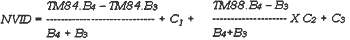
where C1, C2, C3 are experience – related constant parameter.
Accuracy Assessment
Sampling for accuracy assessment was undertaken in a systematic manner for the first three change – detection approaches. Well-distributed 261 pixels with precisely corresponding coordinate between all the imaged examination were selected to asses accuracy by comparing them, with ground reference data, the results being displayed in confusion matrices (Fig. 2)
Examination of overall accuracy of confusion matrix was performed. After denoting a certain significance range ( e.g.p > 0.05), we can calculate the confidence range for the overall accuracy. Assuming that u is correct classification ratio, variance for binomial distribution is s2=m ( 1-m), the confidence interval for m can be computed using following equation:
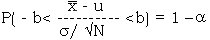
where N is the sum of samples, x is the accuracy for sample, 1 arepresents confidence level. The Kappa statistic was used to test if the overall agreement in the confusion matrices was significantly different. A measure of over all agreement was computed for each confusion matrix. This measure of agreement is calculated by the following equation:
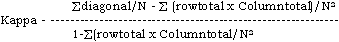
A complete description and discussion of the use of the Kappa statistic can be found in Congalton et al ( 1983).
Result and Discussion
Table 1. shows eigenvalues and eigenvectors of the 8 – dimensional, original data correlation matrix using the combination of B.1, B.2, B.3, B.4 of 1984 and 1988. By analysing the eigenvectors for each PCs image for identifying urban area, nonurban area and new urban area, we determined that the PC1 represented brightness and have largest variance which means it s large amount of ground object information. The usage of PC1 in M.L. Classification was to maintain the correspondence between classified image and ground object for the classified image and ground object for the classified image and ground object for the classified image to be easily comprehended. PC2 approximately represented ??bright and showed new urban area in light, nonurban area imagery to dark, old urban area in dark. PC3 showenewurban area in dark, nonurban area in dark, old urban area in grey and development in very dark. The first three PCs occupied about 99.77% of total variance. From PC4 on, image mainly appeared as noise and became more and more blur. The M.L. Classification of PC1, PC2, PC3 was performed. The extraction of urban – related elements from the classified image resulted in Fig. 3 ( omitted ) in which red indicated new urban area and green was old urban area. The confusion matrix for Fig. 3 was showen as Table. 2. d
Overall accuracy: 85.82%
Confidence interval at 95% confidence level: ( 981.7%, 89.5%)
Kappa value: 0.556
Integrated accuracy for illustrating urban expanding : 68.85%
Comparing Fig. 3 with Fig. 1, it was found that there were mis-classification of newly caltivated fishpool for old urban area. However, in the approach of classification comparision , this sort of mis – classification was avoided. But in band ratio method. fishpool was incorrectly classified as newly constructed
| Component | Eigenvaiu | Eigenvector | |||||||
| 1 | 0.502 | 0.362 | 0.378 | 0.355 | 0.104 | 0.427 | 0.33 | 0.425 | 0.199 |
| 2 | 0.263 | 0.430 | 0.360 | 0.390 | 0.422 | 0.147 | 0.259 | 0.323 | 0.375 |
| 3 | 0.132 | 0.052 | 0.292 | 0.275 | 0.599 | 0.420 | 0.260 | 0.200 | 0.440 |
| 4 | 0.068 | 0.091 | 0.088 | 0.100 | 0.648 | 0.174 | 0.004 | 0.042 | 0.720 |
| 5 | 0.019 | 0.543 | 0.160 | 0.380 | 0.072 | 0.424 | 0.086 | 0.500 | 0.307 |
| 6 | 0.007 | 0.614 | 0.350 | 0.180 | 0.035 | 0.520 | 0.036 | 0.439 | 0.054 |
| 7 | 0.004 | 0.020 | 0.670 | 0.647 | 0.113 | 0.253 | 0.240 | 0.010 | 0.018 |
| 8 | 0.003 | 0.001 | 0.200 | 0.190 | 0.043 | 0.273 | 0.780 | 0.482 | 0.060 |
Table 2. Summrized Confusion Matrix showing Urban Expanding Information, Determined by PCA of Multitemporla 18-Dimentional Data Set
| Interpreted Landuse Conversion Type | ||||
| 1 2 3 | Total Pixels | Omission | Perc. Err | |
| 1. Urban-Urban 2. NonUrban-Urban 3. NonUrban-NonUrban |
87 4 6 | 97 31 133 |
10 9 18 |
89.7 71.0 86.5 |
| Total Pixels | 101 36 127 | 261 | ||
| Errors of Commission | 14 11 12 | 37 | ||
| Percentage erroe | 86. 266.7 90.6 | |||
By the way, PCA was carried out on each pairs of corresponding bands of the two dates respectively. Considering that there is lest correlationship between/ among B1. PC2, B4. PC2 and B7. PC2, M.L. Classification image of these three stable ( no change ) pixels appeared in one color and all the other colors indicated certain landuse change pattern. Now that B1. PC2, B4. PC2 and B7. PC2 represented mostly change information (Lu Jiatu, 1988, J.A. Richards, 1984), the classification image only displayed change pattern, no landuse type.
Table. 3 (omitted) is summarized confusion matrix determined from image classification comparision approach.
Overall accuracy : 87.0%
Confidence interval at 95% confidence level : 82.38, 90.55)
Kappa value: 0.599
Integrated accuracy for monitoring urban expanding : 61.3%
In the resulted overlay image (Fig. 4, omitted ), change taken place in those windows as shown in Fig. 1 were detected well. Although error accumulation will inevitably happen when detecting landuse change by classification comparision, we still can obtain relatively perfect effect for urban expanding monitoring because there is significant difference between the spectral features of urban and nonurban landuse type.
Table 4. (omitted) shows summarized confusion matrix obtained from band ratio and logical calculation method.
Overall accuracy : 87.4%
Confidence interval at confidence level:( 82.82, 90.89) Kappa value: 0.597
Integrated accuracy for illu8strating urban
expending : 61.3%
Table.5. shows us accuracy comparision between/among the three approaches discussed above
On the basis of analysis on Table. 5, some useful conclusion can be drawen. The corresponding accuracy parameters between the approaches of classification comparision and band ratio are very similar and there is little difference between the effects of the two methods. However, PCA approach has showen its
| Overall Accuracy | Confidence Interval | Kappa | Integrated accuracy | |
| PCA Cla. Comp Hand Ratio |
85.7 87.0 87.4 |
81.07 -89.53 82.38 -90.55 82.82 – 90.39 |
0.556 0.599 0.597 |
68.85 61.3 61.3 |
a. Integrated Accuracy for Monitoring Urban Expanding. high value for monitoring urban expanding although its other accuracy parameter are slightly lower than other two approaches.
Conclusion
Some conclusion can be drawen based on research work performed above.
- Space remote sensing data can show its high value in monitoring urban expanding by using advanced remote sensing image processing / analysis system and GIS.
- Several approaches discussed effects for monitoring urban expanding. In the light of confirming each other between / among the several approaches, it can be determined that it was primarily realized to automatically, localizedly and semi-quantitatively monitoring urban expanding.
- PCA approach has its theory basis and showen it s superiority for detecting change information.
- Although the accuracies for monitoring urban expanding in the basis of image processing/analysis have not meet the command for mapping in urban – rural fringe area, the detection effects obtained in this study can give us quantitative information to some extend and direction us to investigate interesting area.
- The extraction of urban expanding information is not simple digital processing and demands deep comprehension on information source, well mastering of all sorts of image processing algorithm, expert knowledge and some experiments.
Acknowlegement
The author are grateful to Porf. Wang Changyao and Prof. Liu Jiyuan (Division of Natural Resources Environment, Institute of Remote Sensing Application, CAS) for advising in the preliminary stage of this study, reading the initial draft of this paper and making very valuable suggestions. The contribution of Prof. Cheng Zhenyi, Prof. Zhu Chongguang and Engi. Chao Zhaofong (IRSA, CAS ) are sincerely acknowledged . The author also extend acknowledge to the remaining personnel who assisted in accomplishing this Study.
References
( omitted )