| GISdevelopment.net ---> AARS ---> ACRS 1992 ---> Poster Session Q |
The use of OR method and
establishment of data bank in Land Resource Survey
Chen Xi
Huangyan City Land, Administration Bureau, Zhejiang, China
Huangyan City Land, Administration Bureau, Zhejiang, China
In 1984, Ke Zhengyi, a vice professor from zhejiang Agricultural put forward OR method, a new way dealing with geographic information of remote sensing by which he developed the Data System of land resource survey under the leadership of Chain national Land Administration Bureau. This system passed technical trusts in February, 1991. It has found out a new economy and easy way for China and other developing countries to establish land information systems on a large scale.
The Data Processing System Of Land Resource Survey, with advanced technological ways and strong data processing ability, is an advanced tool to deal with land resource survey results with computer in ways of vertical correction, area calculation, statistics and picture drawing, etc. The system needs a high quality of operating technique and equipments. When the system is put into actual use, it will happen some troubles on operator’s quality, efficiency, costs and quality of products for tacking of actual widespreading experiments.
In order to fulfill tasks of data processing in Huangyan city’s land survey and put the system into use as early as possible for the oncoming national land survey, Huangyan land Administration Bureau has set up the land survey computer center and researched into some difficulties and problems which probably happen in the course of large-sized use. After one year’s experiments we have improve and enhanced the system, and formed a complete set of management regulations including technical operating system, quality guaranteeing system and organizing measures to meet demands of use on a large scale. Meanwhile we have finished tasks of data processing. of Huangyan Land Resource Survey successfully and established data bank of Huangyan City’s land resource.
This article, based on experiments of Huangyan land survey data band, emphasizes on difficulties and problems which probably happen in the course of use of the system, technical method s and managing measures to solve these problems, and ideas of improving land information system with OR method continuously. The current situation of use of Huangyan City’s land resource
Huangyan city is located in the coastal zone of Mid-Zhejiang. It has an area of 1, 313. 60 square kilometres including 56 percent of mountain and hill, 44 percent of plain and seashore with a favourable weather Huangyan is abundant of fruits like oranges, loquats, red bayberries, etc. It is very difficult to survey land resources because of manifold lands and complicated current situation of use.
In August, 1989 we began surveying for current situation of land resources on the basis of new airphotos with a scale of 1: 10000. In accordance with the Technical Standard Of Survey For Current Situation Of Zhejiang Provincial Land Resources, we divide types of land resources into 3 grades, 84 kinds, with village as a basic unit.
It is the best survey for land resources in Huangyan’s history which features the richest contents, completes detailed division and highest precision. In order to finished next tasks such as hand vertical sketching, measuring area, statistics and compiling thematic maps, we decided to make full use of the System. In july, 1990 we established Huangyan Land Resources Survey Computer Center and bought a complete set of equipments. Meanwhile we employed two technicians and eight operators. After one year’s exploration and research we have solved one series of problems which arisen from large widespreadings, and completed preparation for establishing Huangyan Data Bank Of Land Resources Survey.
The use of OR method
A method so-called OR can substitute the hand vertical sketching and area measuring by Ortho-Rectifying the unit edges upon the identified airphotos and makes thematic mapping as well as area computing be implemented automatically tyby system itself. Digital rectification of identified edges of airphoto is more complicated compared with that of space picture. It can be solved by using the following collinear equation under the condition of vertical aerophotography ( till angle < 3).
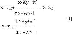
where
f is focal distances of aerial camere. F,w,k,Xc,Yc, Zc, are elements of exterior orientation.
x,y are plane coordinates of image point in fiducial coordinate system.
X,Y are plane coordinates of corresponding object points in object space coordinate system.
Z is elevation of obkect point.
f is a constant and can be found out in direction of aerial camera.
The coordinates of the points of interpreted edges of space pictures will be transformed automatically into those of thematic map after interpreted unit. edges of space pictures are digitized and a polynomial is set up by using corresponding relationship between obvious points both in space picture and standard topographic map, in the same time, thematic maps can be output by using package of CAC, and the unit area can be calculated in coordinates of the polygon’s vertexes. Procedure of OR method is as follows:
1. Location
- The location of airphotos: Combining coordinate system of airphoto with that of digitizer, and make the shrinkage correction of airphotos in the same time.
- The location of topographic maps: Matching the ground plane Cartesian system with that of digitizer, in the same time, correcting the map distortion.
- Point collecting on topographic map.
- Collecting the corresponding ground plane Cartesian coordinates of principle points of photographs by using digitizer to generate I* file ( * is number of topographic map )
- Using digitizer to gather not less than four rectification control points of airphoto in topographic maps and set up 0* file ( * is number of judged in precise both on topographic map and airphoto. But this step may be replaced by inputting the ground coordinates data using keyboard if they are pass points of analytical aerotriangulation.
- Collecting reference points and checking points used for generating DEM, then setting up R*file and S* file respectively ( * is number
- Points collecting on airphoto
- Gathering rectification control points from airphoto and setting up PH$ is number of airphoto).
- Digitizing the identified unit edges of airphotos by using “line model” or “point model” and setting up AC$ file ( $ is number of airphoto). Gathering centroid point of airphoto identified unit, and the attributes of the unit is inputted by using keyboard to set up UC$ file ( $ is number of airphoto).
The procedure of location and collection of points can be implemented by using ready-made GIS software, such as ARC/INFO software or the software that should be programmed in the light of specific conditions.
This procedure includes “close” processing used to check if unit periphery in AC$ data file is closed, “edit” processing to edit those enclosed units, and “adjustment” processing, then EAC$ file ( $ is number of airphoto) is outputted. Pre-processing can be accomplished by using ready-made edit software in GIS, such as ARCEDIT in ARC/INFO software, ect..
4. Commutating rectification elements.
Rectification elements of single airphoto can be computed by transferring files of PH$, O* and I* then, three angle elements and three linear elements of single airphoto are outputted and ABC$ file ($ is number of airphoto ) is set up.
5. Generating DEM.
Transferring R* and S* data file to generate DEM, then outputting XYB@ data file@ is number of DEM block). This step can be omitted if DEM has existed in GIS.
6. Rectifying points of identified unit edge.
Points of identified unit edge are rectified by transferring EAC$, ABS$ and XYB@ data files, then RAC$ data file ( $ is number of airphoto ) is outputted.
7. Rectifying centriod coordinates of identified units.
Transfering UC$, ABC$ and XYB@ data files to rectify centroid coordinated of identified units and output RUC$ data file ( $ is number of airphoto ).
8. Airphoto matching.
We can match the adjacent airphotos and output MRAC$ file ($ is number of airphoto) by tranfering data files of RAC$ and RUC$.
This procedure can be implemented by using ready-made matching program in GIS or those programmed by users in light with specific condition.
9. Outputting thematic maps.
With the help of CAC in GIS, thematic maps can be outputted by transfering MRAC$ and data files.
10. Area computing
RUC$ and MRAC$ data file are transfered to compute area, then UA* data file ( * is number of thematic map) is set up. Area computing program which has existed in GIS or programmed by users according with specific condition. Date flowchart or running OR is as following ( see Fig. 1.):
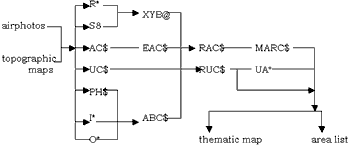
Fig. 1 Data flowchart of OR
Problems
There are some problems existing in the course of widespreading of the System.
1. Quality of operators and technicians
Having not accepted high education and lacking of professional knowledge, the operators can not understand exactly about the System.
2. Efficiency and costs
A large – slzed widespreading and use need high efficiency. Apart from tasks of data processing of local land resources, Huangyan Land Resources Survey Computer center should serve for some nearby counties and cities. without high efficiency, without survival of this center.
3. Quality of products
There are a lot of procedures in inside work of data processing. Any low quality in every procedure will affect quality of products.
Ways to solve problems
(1) Strengthening training of operators
Theory training, Paying great attention to explaining basic principle of the system, status and standard of every procedure in the System, so that operators can understand idea of the System and detailed working standard of every procedure.
Operation training: Increasing operation speed gradually through continuous practising after operators have mastered essential requirements.
(2) Reasonable arrangement of equipments
- Improving and enhancing software of the System with larger contents.
- Making a reasonable professional division of labor between operators and forming a assembly line.
- Fixing standard of every procedure ad compiling a operation handbook to standardize operation and guarantee successful flow of assembly line.
- strengthening feedback and exchange of information between various proce.
There are two ways to test quality, Inner inspection and outer inspection. Inner inspection is one way to find out errors by methematical calculation and logical inference, and check input information with inspection programms.
Outer inspection is one way to examine out information by comparison tooriginal information.
According to the above characteristics or the System we have done the following work to improve quality.
- Improving contents and functions of software to strengthen inner inspection, Information’s can be inspected by color display on screen in order to find out and correct errors promptly.
- Formulating detailed rules of quality inspection for every result.
- Establishing quality system inspected by a special person. Results of every step can not pass on the next one without special inspection
- Stipulating regulations for management of the computer center which includes equipment, maintenance, documents filing, etc.
- Working performance of every operator linking up with salary to motivate their activity.
With establishment and improvement of technical standard and quality management system, our operation efficiency is improving greatly. Now data processing ability of the computer center has reached 250 km2 monthly ( 1 km2 – 80-90 units). Data processing of kilometer costs about RMB* 50 , which is 30 percent lower than that handworked. In Oct. 1991 we completed data processing of Huangyan city’s land survey and passed through test organized by Zhejiang Provincial Land Administration Bureau. All experts agree that Huangyan city’s land survey results are in conformity with instructions.
The study for widespreading of the System and establishment of data bank pave the way for the use of the System widerly in Zhejiang province. The establishment of computer center make it convenient for the use of data. Now are providing datas and pictures to various kinds of departments including agriculture, aquatic, city construction. We are planning to put in soil, water, meteorological information to set up a complete geographic information on the basis of data bank, and make full use of the System to study geographic information comprehensively, serving for development of local society and economy.