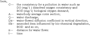
| GISdevelopment.net ---> AARS ---> ACRS 1992 ---> Poster Session Q |
The Analysis of Remote
Sensing For Bay’s Self – purificability
Li Tiefang, Chen Xiaoxiang,
Li Jin
Zhongshan University,Guangzhou 519275, P. R. China
Zhongshan University,Guangzhou 519275, P. R. China
The problems
On the research on bay’s self-purificability , it is difficult only to use a simple water-quality model to express self-purified course in whole bay because there are large changes in space and time for involved factors. The main element to influence bay’s self-purificability is tide, it moves in periodicity and make pollutant diluted, diffused, deposited and transported, and also influence the bay’s bio-chemical environment . In the principle, a simplied one-dimensional water-quality transpiration model is also available, it is as follows:
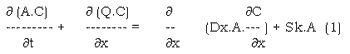
In real application, formula 1 can be simplied and solved by differential difference equation, the parameters Dx and Sx can be expressed by following experienced formula.
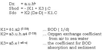
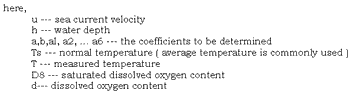
The formula above shows that, Dx and Sk are related with current velocity , water depth and temperature. For the conventional analytical method sampled few points in the bay, it is difficult for using such a few sample points to express actual current field in whole bay because there are large changes in time and space, 80 it is impossible to reach ideal precision.
The paper advanced a way combined remote sensing technique with point investigation to estimate the parameters in a quick , accurate and overall manner.
To apply remote sensed data to parameters estication of water quality mode, It was because there are different velocities in current field that changes the roughness of water surface and influences the spectral value radiated on water surface, so satellite remote sensed data can provide the current filed information.
Signal Lsg, included in remote sensed signal L, is the reflection of surface current field.

among formula 2.
Eosun radiant emittance
(qs, fs) --- sun azimuth and elevation angle
(qr, fr) --- observation aximuth and elevation angle
t --- the coefficient related with atmosphere
r ( ) --- the function related with wave on surface.
Therefore, waterbody, current’s movement direction and relative speed; and their relationship of action of motive power can be clearly shown
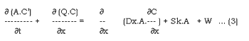
W is the value of water environmental capacity, it can be solved by formula 3.
Conclusion
Remote sensed image can provide more detail complex hydrology information in a bay, from which research workers can well understand bay’s detail background and its movement, which us useful to improve model precision and working efficiency.