| GISdevelopment.net ---> AARS ---> ACRS 1992 ---> Poster Session Q |
Monitoring of surface
temperature daily dynamics using NOAA-AVHRR data
R. Oyun, S. Altankhuyag, S.
Tuya
National Remote Sensing Centre, State Committee for Nature
and Environmental Control,Ulaanbaatar-11, Mongolia
National Remote Sensing Centre, State Committee for Nature
and Environmental Control,Ulaanbaatar-11, Mongolia
Abstract
NOAA-AVHRR data has been used for surface temperature daily dynamic study in high mountains, large lakes and sandy desert area of Western Mongolia It is proposed the method of surface temperature mapping.
Introduction
One of the main component of the Natural Environment Monitoring System is heat and radiation resources of the Earth and for what it is important to estimate real surface temperature. Traditionally, in Mongolia, surface temperature is regularly determined by the contact measurement, that is executed at meteorological stations. But these ground data are spatially discrete and they represent not all types of landscape. For example, there is no regular ground temperature data on top of high mountain, middle of big lakes, sandy desert or forest. It is known that Remote Sensing method is excellent for investigation of the unreachable or hard to reach areas. Satellite sounds not temperature, but emitted radiance, determination of real temperature using emitted radiance demands to solve several problems with spectral bands data integration, atmospheric correction, emissivity variation consideration and so on. As we know these problems are solved more effectively for sea surface temperature estimation.
In Mongolia the study of surface temperature using remotely sensed data is at the beginning. Since multispectral digital regular data receiving the radiant temperature, derived from AVHRR, has been used for cloud, snow cover, soil moisture, evaporation estimation and fire detection. But radiant temperature variation and its dynamic is not studies in detail before. We investigate the possibility of AVHRR data application for diurnal temperature dynamic study. It is determined the radiant temperature on the top of high mountains with perennial snow cover, sandy, plain, lakes and forest. This paper presents some results of our investigation.
Data and Methodology
Night, morning and afternoon orbits AVHRR data from 16th July and 22, 23, 24th October, 1900 have been used for temperature study. Ground data, measured at meteorological stations and during field observation points is used for estimation for result accuracy. Area of Monglo-Altai mountains and Uvs-nurr hollow located in western part of Mongolia and having different types of landcover, have been selected for this study.
AVHRR data is geometrically transformed and radiometrically corrected.
As well as channel 4 of AVHRR data us thermal infra-red band, which exists on both of operating satellites, we estimated daily dynamic of temperature by radiant temperature variation, derived from channel 4. Absolute value and diurnal amplitude of the surface temperature are determined by integral radiant temperature.
Integral radiant temperature calculated via regression equation was derived in France for sea surface, (WMO.TD No. 245, 1987), with consideration of surface emissivity:
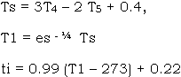
Here T4, T5,- spectral radiant temperature derived from channels 4 and 5 of AVHRR data. Ts, T1 – integral radiant temperature of sea and land surfaces, es – surface emissivity, ti – derived surface temperature.
Multischannel classification method has been used for identification of mountain, forest, sandy area, perennial snow coverage and water surface.
Results and Discussions
1 Calculated surface temperature accuracy
The accuracy of the remotely sensed surface temperature was estimated with help of real surface temperature, measured by thermometer at the ground stations. These two data have different ground resolution but comparing calculated and measured temperature values we found that average accuracy of the surface temperature sounding is less than 2.5 degrees (Table 1). It is interesting that there is different sign of errors at day and night times. The main reason of it might be atmospheric transparency and surface emissivity variation peculiarity at different times, of a day. For some situations these differences range more than 3 degrees and we connect facts with different ground resolution and uncorrespondence of certain surface emissivity.
From this analyse we concluded that the calculated integral radiatn temperature could be used for study of surface temperature in homogeneous area with known emissivity.
2 Temperature dynamic on the top of mountains
Mountainous area and high mountains with perennial snow coverage are clearly identified by albedo and radiant temperature. But for the study we could find very few cases where satellite data is could free in whole day. Particularly in summer, the mountain area is under cloud, especially at the afternoon and it reduces the number of case study.
Really, different mountains have different surface cover like snow coverage, vegetation, bare soil or rock stone, therefore to calculate integral radiant temperature it is necessary to use corresponding emissivity value. But in our case we have used mean value of the emissivity equal to 0.95.
There are observed temperature differences between high mountains, sandy desert and water surface (Fig. 1). Mountain area is colder than sandy desert by more than 20 degrees. Even in the warmest month of a year, the mountains higher than 3000 meters have temperature below 00 C at the night. There is also a diurnal temperature dynamic on the top of high mountains. In Fig. 1A is shown day and night times integral radiant temperature mode value for mountains of the different altitude. Usually, the diurnal temperature amplitude comes down with an increase of altitude. There is exception, mountain Altan-Khukhii is higher than mountain Khan-Khukhii, but it has more temperature amplitude because for the landcover of these mountains is different. Khan-Khukhii mountain is covered by meadow lands and forest, but Altan-Khukhii is covered by steppe and desert-steppe vegetation. The highest mountain of Mongolian Altai Tavan Bogd and Munkh Lharikhan with altitude of more than 4000 meters, also have diurnal temperature amplitude about 10 degrees. Daily temperature dynamic of these mountains remained even in autumn (table 2).
Due to absence of ground true data we could not estimate the accuracy of the calculated daily temperature amplitude in mountain area. But yield observation data showed that in mountain Kharkhiraa and Turgen the average daily temperature amplitude in July ranges 31.20 C at 2200 meter and 28.60C at 2800 meter (Tseveendorj, 1991). Thus there is no reason to ignore our result. Temperature value on the top of mountains depends on altitude. The higher mountain has lower temperature. The dependence is clearly identified by night time data (Fig. 2).
3 Gobi and sandy areas’ temperature dynamic
Big Sandy areas are delineated very well by its albedo value. But it is difficult to define the sandy areas’ boundary by radiant temperature values.
Emissivity of the sandy surface ranges between 0.90 – 0.96 (Kondrateiv, 1970, manual of Remote Sensing, 1983). It depends on sand component, granule and moisture condition. Here we used the value equal to 0.90.
On Fig. 1. it is shown the integral radiant temperature range, mode value and spectral radiant temperature daily dynamic of the biggest sandy area in Western Mongolia. Daily dynamic of sandy surfaces is more than others and it ranges no less than 30 degrees. In comparison of water surfaces at the night the temperature of sandy surface cool down with 5 – 10 degrees and during daytime it goes up with 20 – 25 degrees.
The temperature field of sandy area is not homogeneous as albedo. It has spatial variation, depending on relief and gobi vegetation.
4 Temperature dynamic of the water surface
Water surface is clearly classified on all channels of AVHRR.Fig. 1 shows minimum, maximum and mode integral radiant temperature value and spectral radiant temperature daily dynamic of various lakes. In contrast to other surfaces morning. temperature of water is coldest one. Water surface temperature is 4 – 9 degrees more at the night, 3 – 6 degrees less in the morning and 18 – 22 degrees less in the afternoon than surrounding land areas temperature.
We compared of water is coldest one. Water surface temperature values. Usually at the ground lake water temperature is measured twice a day at 8 and 20 hours near to the lakeside, so the meaning of this temperature is different. But we found that measured temperature is not so far from temperature, derived from satellite data.
It has occurred a question, to which depth of water the remotely defined temperature does relate. The answer would be ready, if exists vertical temperature profile in lake water. But ground measurement field study, carried out in Uvs-nuur hollow (Shelkhrot, 1990) for lake of Khar the temperatures at surface and 4 meters depth of water are equal and for lake Duruu the difference of water temperatures at surface and 8 meters depth is 0.10 – 1.00. Therefore we could say that, the defined temperature represents at least up to 2 – 3 meters of water depth.
There is a good correlation between lake surface temperature lake location altitude and lake water depth (Fig. 3). On Fig. 4C. is shown the integral radiant temperature spatial variation of lake Uvs. The lake surface temperature distribution is different at night and day times. North eastern side of Uvs lake is not deep and has more influence of the surrounding land. So, here the daily temperature dynamic reached upto 3 – 6 degrees. But the western side where is observed more depth has 0 – 1 degrees amplitude.
5 Surface temperature mapping
Discrete ground measured data does not allow to map surface temperature. But with help of satellite data this is possible. Data processing for surface temperature mapping should include following components.
- Preparing of landcover class map and corresponding emissivity values.
- Atmosphere correction.
- Calculation of integral radiant temperature
- Distinction of cloudy and non-cloudy area,
- Correction of integral radiant temperature with help of regular ground measured data,
- Objective classification of temperature data and preparation of the map.
Conclusions
Using AVHRR data it is possible to map surface temperature over territory of Mongolia and identify mountains, lakes, forest sandy Gobi and define their daily, monthly and annual temperature dynamics at least in relative form. In clear sky and high transparent atmospheric condition the temperature accuracy is +2.50C, when correctly considered the surface emissivity omitting of the emissivity gives error more than 100C
References
WMO/RD (1987) Application of Satellite Technology // Annual Progress Report, Technical Document WMO/TD No. 245, 118pp.
Tseveendorj, (1991) Kharkhiraa, Tugen mountain area field trip, report, Ulaangom.
Kondratiev K. Ya., Timofeev Yu. M. Satellite thermal sounding of atmosphere. Leningrad, Hydrometeoizdat, 1970, 410pp.
Shelkhrot G.S., Kretova S.P. and Smirnova E.V Ecosystem of Uvsnuur lake, water potential and quality /information problems of biosphere study. Pushino, 1990, 286 – 303pp
Manual of Remote Sensing, v.II : Interpretation and Applications. ed. Robert N, John E. American Society of Photogrammetry, Virginia, 1983.
Calculated land surface temperature accuracy
| N | Station name | Night time (°C) | Day time (°C) | ||||
| Satellite data | Ground data | Difference | Satellite data | Ground data | Difference | ||
| 1 2 3 4 5 6 7 8 9 10 11 |
Nogoon-nuur Ulaangom Baruunturun Ulgii Umnu-Gobi Zavkhan Yalalt Khovd Deluun Dochin jil Zereg Average |
12.6 13.9 10.6 13.9 11.4 17.6 5.7 15.0 7.8 5.7 15.0 |
11.1 11.3 9.5 12.0 7.6 14.924.7 13.0 8.0 8.5 18.6 |
1.5 2.6 1.1 1.9 3.8 2.7 1.0 2.0 -0.2 -2.8 -3.6 2.1 |
44.6 46.6 45.0 46.6 29.9 49.4 35.4 42.5 43.5 44.6 |
45.4 53.5 49.5 49.4 32.4 50.7 37.2 42.0 44.2 42.1 |
-0.8 -6.9 -4.5 -2.8 -2.5 -1.3 -1.8 0.5 -0.7 2.5 -2.4 |
Table 2
The spectral radiant temperature on the top of high mountains (channel-1, 10.5 – 11,5 mkm)
| Mountains | Day | Oct 22 | Oct. 23 | Oct. 24 | |||
| Time | 09:54 | 15:47 | 04:04 | 09:32 | 15:35 | 03:53 | |
| Tavan-Bogd Muunkh-Khairkhan Tsast |
-38 - -33 -41 - -352-41 - -35 |
-29 - -23 -30 - -272-30 - -27 |
-28 - -25 -31 - -27 -28 - -25 |
-34 - -25 -33 - -27 -30 - -23 |
-21 - -12 -24 - -19 -24 - -19 |
-26 - -22 -28 - -22 -26 - -22 | |
A. Integral radiant temperature
| Mountains | Night | Day | |
| Khan-Khukhii Altan-Khukhii Much-Khairkhan Tavan-Bogd |
6 0 -7 -9 |
25 31 3 3 |
| Sundry area | Night | Day | |
| Shargyn Gobi Altan Els Baruun Khuurai Khuisiin gobi |
18 – 21 19 13 – 18 18 15 – 21 17 16 – 18 18 |
44 – 47 22 52 – 58 54 48 – 52 52 44 – 54 51 |
| Mountains | Night | Day | |
| Uvs Khar-Us Khyargas Uureg |
18 – 23 19 18 – 21 21 19 – 21 20 10 – 16 12 |
20 – 26 20 23 – 29 25 18 – 26 19 18 – 23 19 |
Figure 1. The daily dynamic of radiant temperature( 16. July, 1990 )
Figure 2. The relationship between spectral radiant temperature and mountain top altitude.
( 16 July, 1990 night )
Figure 3. he relationship between lake surface radiant temperature and altitude ( Number in brackets is lake water depth )