| GISdevelopment.net ---> AARS ---> ACRS 1992 ---> Poster Session P |
Ground target recognition:
The operationally of Remote Sensing techniques in the tropics
Mazlan Hashim,Mohd
Ibrahim,Smasudin Ahmad,Sarudin Awang
Center for Remote Sensing, Faculty of Surveying
University Teknologu Malaysia, Locked Bag 791
80990 Johor Bahru, Malaysia
Center for Remote Sensing, Faculty of Surveying
University Teknologu Malaysia, Locked Bag 791
80990 Johor Bahru, Malaysia
Abstract
The successful extraction of information from satellite remotely sensed data are largely influenced by two dominant factors i.e. the atmospheric interferences inherent in the data and the target’s own spectral response behavior. The atmospheric effects can be compensated by using suitable atmospheric model. The target’s spectral signatures on the other hand are unique which enable their recognition. In reality, the target’s recognition from remotely sensed data is not trivial particularly in humid tropic regions.
This paper addresses the manipulation of digital data from the Landsat-5 TM and SPOT-1 multispectral data in order to obtain optimum classification accuracy for some selected land use categories. Summary of targets accuracies on classification of the manipulated and original data sets are tabulated. The results show that manipulation by spatial filtering and principal component analysis on the data sets have improved the classification accuracy of 6 land use categories by as much as 45 percent.
Introduction
Recognition of different land use classes from Remote Sensing data poses significant problem in humid tropic regions. This problem is mainly due to the minimum heterogeneity of the classes which will result in poor identification of classes to which they belong in the classification process. Some prominent factors discussed by Schowengerdt (1983) that cause variability within the classes are atmospheric scattering, topography, sun and view angles, class mixture, and within-class reflectance variability. Several processing techniques attempted by Hashim and Ahmad (1989) proved that best seprabilities among land use classes can be optimized using vegetation indices, statistical filtering and merging of data from different sources.
Paper presented at the 13th Asian Conference on Remote Sensing. 7 – 11 October 1992, Mongolia
This paper will further analyze the technique of statistical filtering of the data and utilize the transformed data together with the original data as input in the principal component analysis (PCA). The PCA method was utilized to reduce the number of images that are needed for classification.
Study Area and Data Acquisition
The study area is centered on the small town of Bedong, Kedah Peninsular Malaysia with approximately 80 square kilometers (10 km X 8 km) of various land cover types. The primary land cover is rubber, oil palm, forest, mangrove and a significant portion of mining area in the western part of Bedong. Water features include rivers and disused mining pools. The North and South Highway passes through the center of the study area with other transportation network that includes railways, two-way roads and tracks.
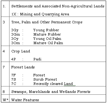
The data used for the identification of land use and cover types were the 1985 Ministry of Agriculture Land Use Map and 1988 Topographical Maps at a Scale of 1:50000. The satellite data used in the study were the Landsat -5 TM data of 12 February 1991 (WRS 128/56) on bands 1 to 5 and 7, and the SPOT-1 MLA data of 6 August 1988(K/J 266/339). Several land use classes based on the national legend (Wong, 1974) were adopted for the classification process in the study area which are indicated in Table 1. Water features including rivers and mining pools were also included in the legend since they feature prominently in the image.
Data Processing
The satellite data were geometrically corrected before spatial filtering and principal component analysis were carried out.
1 Spatial Filtering
The contribution of spatial filters in the processing, before any classification takes place reduce the internal variation within the land use categories and improve the texture properties of the image data (Cushnie and Atkinson 1985). In this study, a 3 x 3 moving window filter with the returning values of standard deviation, mean and variance of the original image data to its center pixels were employed. The transformation resulted in 3 new data files for each TM bands to give a total of 18 data files. A total of 9 data files were created for SPOT data.
2 Principal Component Analysis
Principal component analysis of remotely sensed image data has been used for various information extraction purposes. One of the major use of PCA is to reduce the number of images or variables that are needed for analysis. In this study 18 data files from the spatial filtering process together with the original 6 TM bands were applied in the PCA. For the SPOT data, the 9 data files created from the spatial filtering process together with the original 3 multispectral bands were used.
Supervised classification using maximum likelihood classifier were carried out on the first three components of the principal component image for each set of satellite data. These first three components will have a large percentage of the total variance present in the data sets. Classification on the original 6 TM bands and 3 SPOT multispectral bands were also performed so that they can be used as standard for comparison in this study.
Results, Discussions and Conclusions
In Table 2, the PCA Method decreases the classification accuracy of 3 land use categories namely mangrove (8), forest (7F) and mature oil palm (3Om) in comparison with classification on the original TM bans. The decrease in the classification accuracy is 8 percent for forest and mangrove and 3 percent for mature oil palm. Improvement in accuracy values of between 6 to 36 percent has been achieved with PCA Method for 6 land use categories. The largest increase in accuracy is obtained by the class pady (4P) with a value of 36 percent, followed by young rubber, 3Gy (39 percent), water, W (9 percent), mining area. 1X (8 percent), young oil palm, 3Oy (6 percent) and 5 percent of mature rubber (3Gm).
* Additional land use chosen for this study
With the SPOT data, (Table 3), the accuracy of 6 land use categories were improved by as much as 45 percent if the PCA method were used. The newly cleared area (7C) has improved accuracy of 45 percent, young rubber (42 percent) scrub forest, 7S (30 percent), mature rubber (25 percent), water (19 percent) and mature oil palm (6 percent). However, the other 3 land use categories have accuracy lowered by 1 to 19 percent i.e. mining area (1 percent), forest (11 percent) and mangrove (19 percent).
The effect of spatial filtering both TM and SPOT data has increased the overall accuracy of most the land use classes (targets) being tested. However, not all targets can be easily recognized, which has resulted in lower classification accuracy.
References
Cushnie, J.L. and Atkinson, P. (1985), Effect of spatial Filtering on Scene Noise and Boundary Detail in Thematic Mapper Imagery. Photogrammetric engineering and Remote Sensing. Vol 51 No. 9 PP 1483 – 1493.
Hashim, M. and Ahmad, S. (1989) Optimizing the Target Seperatability of Covertypes Inventorying of Humid Tropical Region. Proceedings of Global Natural Resource Monitoring and Assessments: Preparing for the 21st Century, Venice, Italy. PP 1307 – 1316.
Schowengerdt, R.A. (1983), Techniques for Image Processing and Classification in Remote Sensing, New York: Academic Press, 1983.
Wong, I.F.T. (1974), The Present Land Use of Peninsular Malaysia. Ministry of Agriculture, Kuala Lumpur.
| Theme | No of Pixels | % correct | Commission Error | ||||||||
| 3Gy | 3Gm | 8 | W | 1X | 7F | 3Om | 3Oy | 4P | |||
| 3Gy | 517 | 98 69 |
509 458 |
0 0 |
0 0 |
0 0 |
0 53 |
0 0 |
0 0 |
0 0 |
0 0 |
| 3Gm | 3668 | 98 93 |
0 0 |
3610 3412 |
0 0 |
0 0 |
0 0 |
0 0 |
0 0 |
0 0 |
0 0 |
| 8 | 1375 | 79 87 |
0 0 |
0 3 |
1081 1200 |
0 0 |
0 0 |
79 0 |
56 43 |
0 0 |
0 0 |
| W | 751 | 94 85 |
0 0 |
0 0 |
0 0 |
706 640 |
0 0 |
1 0 |
0 0 |
0 0 |
0 0 |
| 1X | 544 | 67 59 |
0 0 |
0 0 |
0 0 |
0 0 |
363 325 |
0 0 |
0 0 |
0 0 |
0 0 |
| 7F | 3021 | 82 90 |
0 0 |
0 0 |
233 0 |
15 0 |
0 0 |
2466 21727 |
5 0 |
0 0 |
0 0 |
| 3Om | 4406 | 88 91 |
0 0 |
95 84 |
1 1 |
0 0 |
0 0 |
0 0 |
3875 4037 |
77 77 |
0 0 |
| 3Oy | 1324 | 61 55 |
0 0 |
270 267 |
0 0 |
0 0 |
0 8 |
0 0 |
85 62 |
810 734 |
0 0 |
| 4P | 1458 | 81 45 |
109 0 |
0 0 |
0 0 |
0 0 |
0 0 |
0 0 |
0 0 |
0 0 |
1188 667 |
Table 3 Classification Results using the PCA Technique (in bold) and the Original SPOT bands.
| Theme | No of Pixels | % correct | Commission Error | ||||||||
| 3Gy | 3Gm | 8 | W | 1X | 7F | 3Om | 7C | 7S | |||
| 3Gy | 1615 | 72 30 |
1168 488 |
0 6 |
14 39 |
0 0 |
25 0 |
0 0 |
44 98 |
206 342 |
10 93 |
| 3Gm | 5525 | 87 62 |
3 0 |
4797 3400 |
31 105 |
0 0 |
0 0 |
0 0 |
357 381 |
0 0 |
15 0 |
| 8 | 973 | 49 68 |
41 56 |
68 91 |
479 659 |
0 0 |
0 0 |
79 0 |
2 2 |
127 0 |
41 5 |
| W | 972 | 91 72 |
64 238 |
0 0 |
0 0 |
888 704 |
0 0 |
1 0 |
0 0 |
0 0 |
0 0 |
| 1X | 782 | 83 84 |
53 21 |
0 0 |
0 0 |
0 0 |
652 654 |
0 0 |
0 0 |
5 7 |
024 |
| 7F | 1457 | 48 59 |
29 8 |
261 294 |
313 106 |
0 0 |
7 0 |
2466 2727 |
16 43 |
53 0 |
28 0 |
| 3Om | 1796 | 88 82 |
21 20 |
147 170 |
2 85 |
0 0 |
0 0 |
0 0 |
1584 1479 |
020 | 21 0 |
| 7C | 1858 | 74 29 |
460 1273 |
0 0 |
0 0 |
0 0 |
9 4 |
0 0 |
0 0 |
1359 2539 |
0 0 |
| 7S | 1285 | 75 45 |
92 36 |
5 84 |
33 4 |
0 0 |
0 0 |
0 0 |
33 0 |
112 316 |
961 573 |