| GISdevelopment.net ---> AARS ---> ACRS 1992 ---> Mapping from Space |
New Possibilities for SAR
Observations
Nobuhiko
Kodaira
Remote Sensing Technology Center of Japan
Remote Sensing Technology Center of Japan
Abstract
SAR is a side-looking active microwave sensor and is qualitatively different from conventional passive optical sensors. It is reputed to be all weather capabilities, however, single parameter SAR such as JERS-1 is under many restrictions on its observed informations. We should realize that the correct understanding of the present SAR situation. In this paper interferometry SAR will be summarized as a leading means for the single parameter SAR.
Introduction
At present we have 2 operational space borne synthetic aperture radar (SAR), ERS-1 and JERS-1, and near future we will have RADARSAT and SIR-C. SAR is an active sensor operating in microwave region and has a capability to image in all weather conditions unimpeded by the presence of rain particles, clouds, air moisture, and dusts, also independent of solar illumination. However, as the wavelength of microwave sensor is 104 ~105 times longer than optical sensor, observed image has inherently different characteristics to that of optical data.
The development of polarimetric and interferometric SAR (INSAR) is being watched with keen interest. The polarimetric SAR is to use multi-parameter such as multi-frequency, multi-polarization (either horizontally or vertically polarize waves are transmitted and receives both polarized return) provides unique capabilities for monitoring physical and biological properties of the earth surface which cannot be measured by conventional instrument operating at visible and IR regions. Some polarimetric SAR results has been reported from airborne SAR system and is full of hope for the future microwave Remote Sensing of earth surface. (1) (2) The system of polarimetric SAR is rather large and complicated and has some difficulties for the space borne systems. The first experimental spaceborne polarimetric SAR will be flown in around 1995 by SIR-C.
Polarimetric SAR seems to be favorable for the volume scattering targets such as forest, vegetation because scattering of these targets will largely contributed from volumetric scattering and radio wave polarization will be influenced by reflection at the target. Polarized wave contains the target reflection characteristics which cannot be measured by other means of Remote Sensing.
Measurement of Topography
The extraction of topographic information from Remote Sensing systems may be accomplished in several ways. In conventional stereo photography, the parallax between two spatially separated images is used to extract the three dimensional images. SAR images can be used in the same way with the added advantages of all weather capability and large areal coverage, but at the cost of speckle noise not presenting optics. Also it is needed to use two off-nadir angle antenna system for this type of stereoscopic method and single parameter SAR system such as JERS-1 cannot apply this system.
Interferometric synthetic aperture radar is a more sophisticated and accurate technique in which tow images, either from two antennas or nearly repeat ground-track orbits to measure the phase of the pixel of interest.
Thus SAR measurement can provide precise topographic information. This is the …….st significant merit that the single off nadir angle SAR can measure topographic height information by themselves. (3) (4) (5)
In a conventional imaging radar interferometer, two receiving antennas …..parated slightly in cross-track direction view the same scene and altimetry information is deduced from the phase differences between the corresponding pixels in each images. It is possible to perform the same measurements with …nly one antenna by making two images of the scene on two separate paths. If …e two orbits are parallel and separated in the cross track direction, ….titude information is derived exactly as in the two antenna interferometry and the baseline is determined by the orbit separation.
Principle of INSAR
Fig. 1 illustrate the general idea of space borne single antenna INSAR. SAR transmitter S1 and S2 of near by two orbit illuminates target T2. The slant range from SAR to T1 is R1 and R2, incident angle is q1 and q2. The phase difference Fr1 between R1 and R2 is given by,
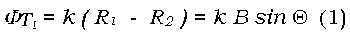
where q is off-nadir angle, k = 2p/l, and B is the base line distance between S1 and S2.
If T1 moves to T2 by ground spacing x and y, slant range R1 and R2 will be R1’ and R2,’ phase difference FT2 between R1’ and R2’ is given by,

phase difference qD between qT1 and qT2 under the assumption of DQ << Q
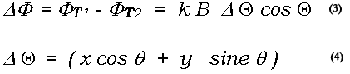
where Dq is the angular spacing between T1 and T2 looking from S1.
Suppose T1 is n-th null point and Dq is 2p, then T2 become n+1 th null point. Drawing contour lines on the same phase angle, every 2p for instance, parallel contour map can be drawn against B, l, Q, (q), and R. Ground spacing x between successive null lines is given by for the flat surface
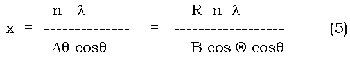
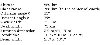
Considering the parameters listed in Table 1 for JERS-1 and B = 1 Km. Contour line interval of x for the flat terrain is given by
The contour line intervals must be greater than twice range resolution. Maximum base line distance Bmax is given by from (5),
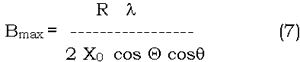
Fig 1. Schematic diagram of INSAR. showing base line separation B and contour intervals x.
Table 1. JERS-1 parameters
where X0 is the range resolution and Bmax for JERS-1 case is 7.2 km. If T2 is located above a local spherical earth by h as shown is Fig. 1,
where y is the displacement from parallel contour lie (5) for flat terrain. We can finally get the relative terrain height h.
Error consideration
There are four main contributions to the phase error: Signal to noise, number of looks, pixel misregistration, and base line decorrelation. Since the SAR is a coherent radar, each pixel obtained suffers from the well-known speckle. Multiple looks are usually average to reduce the fading noise. It is intuitive that the phase measurement accuracy depends upon the number of looks averaged.
INSAR technique has significant advantages and a relatively low cost, but several aspects make its operational use unlikely: baseline indetermination and variation, images not taken simultaneously, strong decorrelation due to changes in backscatter characteristics of the terrain, and orbit selection for an adequate coverage.
If the two antennas are separated by a large-enough distance B, the two measurements of the same pixel would essentially give rise to two independent looks, entirely analogous to the azimuth looks obtained along track. This suggests that while one tends to use a large baseline separation to increase the height measurement accuracy, one should not increase it beyond certain limits.
Although the height measurement sensitivity increases with baseline separation, the phase error increases with baseline as well. It is important, of course, that the surface remain nearly uncharged over the time of multiple observations. The demerits of this technique are: base line indetermination, images not taken at same time induce changes in backscatter characteristics of the terrain condition especially in the case of JERS-1, time difference will be at least 44 days. This technique, for example, cannot be applied over the ocean surface. The accuracy of derived height will depend on this scene coherency. Another important problem in measuring the interferometric phase is the removal of the multiple 2p ambiguities in the phase measurements. Any error in this phase detection procedure will lead directly to error in height measurements.
Future strategy
As mentioned above, single antenna interferometric SAR is most adequate for present operating single antenna SAR systems. However, it is necessary to overcome many disadvantages mentioned above.
Differential radar interferometry may also be used to detect the inflation of volcanoes, as well as portent of earthquake displacement. SAR interferometry is considered one of the most promising techniques to satisfy various scientific applications which require a digital elevation model over large are of the world.
Two antennas system are also proposed by Moccia and Vetrella (4), in which two vertically spaced antennas are connected by a tether downwards to be deployed from future space stations.
References
- F.T. Ulaby et al. “Radar Polarimetry for Geoscience Application. Artech House Inc. 1990.
- J.J. Van Zyl, “Unsupervised Classification of Scattering Behaviour Using Radar Polarimetry Data.” IEEE Trans. Geosci. Remote Sensing. Vol. 27, No. 1, pp. 36-45. 1989.
- Fuk K. Li and R.M. Goldstein, ‘Studies of Multibaseline Spaceborne Interferometric Synthetic Aperture Radar” IEEE Trans. Geosci. Remote Sensing, Vol. 28, pp. 88-97, 1990.
- A. Mocia and S. Vetrella, “A Tethered Interferometric Synthetic Aperture Radar (SAR) for a Topographic Mission” IEEE Trans. Geosci. Remote Sensing, Vol. 30, pp. 103-109, 1992.
- A.K. Gabriel and R.M. Goldstein, “Crossed orbit interferometry: theory and experimental results from SIR-B’ Int. J. Remote Sensing, Vol.9 No.5 pp. 857-872.