| GISdevelopment.net ---> AARS ---> ACRS 1992 ---> Land Use |
A Research on Remote Sensing
Image Computer Recognition of Urban Land - Use Based on Knowledge
Hu Baoxin Zhu
Chongguang
Institute of Remote Sensing Application
Chinese Academy of Sciences, P.O. box 775
Beijing 100101, P.R. China
Institute of Remote Sensing Application
Chinese Academy of Sciences, P.O. box 775
Beijing 100101, P.R. China
Abstract
Urban remote sensing is an important direction in the field of remote sensing , Because urban remote sensing is very complex , every class isn't; homogeneous, better result can't be obtained by conventional classification methods using only spectral information. An algorithm is presented here which integrates spectral, textural and spatial information under the direction of experts' knowledge in the classification process.
In this paper, we use the method to experimental research on Beijing area, using TM 1-7 bands. Experimental result represents: the classification precision of the method developed by us in this paper is 7 percent higher than the conventional maximum - likelihood classifier.
Introduction
The information content of an image resides both in the intensity ( color) of each individual pixel and in the spatial arrangement of pixels ( i.e. texture, shape and context )., Standard image classification procedures, which are always used to extract information from remotely sensed data, are based on spectral characteristics alone, spatial characteristics are usually ignored.
A spectral classifier will be ineffective when applied to classes such as "residential" and "urban" that are distinguished primarily by their spatial characteristics. For the spatially complex, spectrally mixed classes, classification accuracy would likely be improved if the spatial properties of the classes could be incorporated into the classification criteria. There are some methods which can integrate spectral, spatial and texture information in the classification process.
In this paper, we develop a urban land - use classification method based on knowledge using fully the spectral, spatial and texture information of remote sensing images. At first , 1. select some bands to be classificated using possibility relaxation classifier; 2. obtain water map by classifying band 6 using maximum - likelihood classifier; 3. obtain new - built areas map by K - L transform to some selected bands; 4 . obtain urban and residential areas map by texture analysis to band 4. Then, under the guide of experts' knowledge we combine these maps effectly to classify remote sensing Image.
The Description of The Algorithm
In this paper, we develop an urban land - use classification method. Fig. 1 shows its structure. The method is different from conventional classification methods. It not only uses spectral information, but also uses spatial and texture information and use experts' knowledge.
- Band Selection
In order to classify effectly the TM images using spectral information, we have to select several or all bands of TM images. The principle of band selection is: the scatter degree among various classes is bigger and the scatter degree of each individual class is smaller. According to the principle, we define Sb representing the scatter degree among various classes, Sw representing the scatter degree of each individual class and J.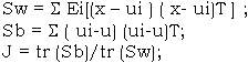
Where
ui = Ei [x] -- the mean matrix of the sample set of each class
u = E[x] - mean matrix of the sample set.
To various band group, calculate J by the classes to be identified. If the value of J is maximum, the spectral group is optimum. So we use these spectral bands to do classification
- Possibility Relaxation Classifier
Possibility relaxation classifier makes full use of the correlativity among the neighboring pixels. First, modify the possibility value of the center pixel by the possibility value of neighboring pixels belonging to various classes. Then, classify the center pixel by modified possibility value. The course of modifying likelihood value is an iteration course. Its algorithm is as follows.
Calculate the possibility value of each pixel Ai belonging to each class Rj, pi (Rj), by maximum - likelihood classifier, and modify the possibility value by the possibility value of the neighboring pixels of the pixel Ai belonging to Rj.
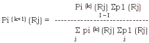
where k is the number of iteration, repeating the process until the different value between the nearest pi (Rj) is smaller than a given threshold. After the process, we obtain the possibility value of ever pixel belonging to R1-Rn, and classify the pixel by possibility discrimination principle.
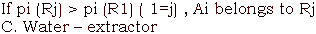
- Water - extractor
Band 6 records heat radiated from the surface. Warm areas are bright and cool areas are dark. In this daytime image, water, vegetation and moist soil are relatively cool, while bare, dry soil and urban areas are relatively warm. Because in the classification map by possibility relaxation classifier, water area is confused with bare soil and urban areas. We can obtain a water map by maximum - likelihood classifier by the band 6 and will modify the classification map with it. We can obtain better water map by maxi- Mum - likelihood classifier to the band 6.
- K. L. transform
The aim of K - L transform is removing the correlativity among TM bands and enhancing a certain feature. In the process of urban land-use classification, we should extract the information of new - built areas and urban and residential areas precisely. But in the classification map by possibility relaxation classifier, the new - built area is confused with bare and dry soil.
By analysis the spectral value of various classes in TM 1 - 7 bands, we known that the second principal component after K - L transform to TM 1,2,3, reflects the features of the new-built area. So we can obtain a nwc-built area map by the second principal component.
- Texture analysis
Texture is a fundamental characteristics of image data and is often crucial to target discrimination. Texture plays an important role in manual photo interpretation. The phenomenal capability of humans to discriminate textures indicates that a large improvement may be possible if texture is incorporated into the classification process. To overcome some of the limitations of spectral classification and tap some of this potential. Many texture analysis methods for digital images have been developed. Here, we use fratal dimension to extract texture information. The method is simple than other texture analysis methods.
We apply the way of calculating fractal dimension in one -dimension to two-dimension space. We consider an image gray surface as a fractal surface, considering the pixels which are r away from the surface and enclose the surface with a 2r-thick shell whose maximum is USr, minimum is BSr. Supposed the gray function of the image is f ( i,j), the starting condition is:
USO (j,j) = BSO (I,j) = f(I,j)
To r=1,2,3…., define maximum, minimum function as follows:
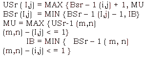
Where we use Four - neighbors, i.e. (m,n) is he four -neighbor pixels of (I,j). When BSr (x,y) < f< USr (x,y), pixel ( x,y) will be contained in the shell r away from the surface. After obtaining the surface. After obtaining the maximum and minimum, we can get the volumn and the surface area:
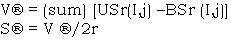
By Mandelbrot formula, we known that S ® =K * r(2-D), Log (S®) =(2-D) logr+K. To fractal surface, it should be a straight line, whose slant degree is 2-D; To non-fractal surface, it is a curve. So we take slant degree KL ® as surface feature of every gray value, to every three points.
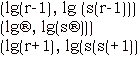
We can calculated the slant degree DL ® by the three points, so we can get the Fractal dimension.
The key problem in calculation of texture feature is the size of the texture window. We know that the bigger the size of the window is , the more the texture information it contains. The texture is easily recognized. But to remote sensing image, we can,t select the bigger window. Because if we selet a bigger window, there are many kinds of texture information in the window. It is difficult to identify the texture. We select 8* 8 window its fractal dimension by the way mentioned above and form a faractal dimension image. Urban and residential area is more obvious than other classes. So we can get urban and residential area map by the fractal dimension image.
- Knowledge system
By several steps mentioned above, we obtained a classification map and some thematic maps such as water map, new - built map and urban residential map. The next question is how to make use of these maps.
In general , in the classification result by conventional maximum likelihood classifier, the classification precision of urban and residential area is lowest.
The urban and residential area is usually confused with water area and bare farmland. So in order to improve classification result, we must modify classification map by use some thematic maps. Comparing classification map with some thematic maps, getting the pixels which are different between these maps. Then, we modify the pixels in the classification map. In order to describe the way briefly, we take the water for example. In the water thematic map, a pixel belongs to water. If the pixel also belongs to water in the classification map by the possibility relaxation classifier we consider the classification result of the pixel is right; If the pixel doesn't belong to water, we consider the classification result of the pixel is wrong, and should modify the classification result. In the modification process, we can modify the classification result into a right classification result under the experts' knowledge and can also classify the pixel again by the maximum - likelihood classifier, if the possibility value belonging to a certain class except water is maximum, the pixel belongs to the class.
In this paper, we use 1-7 TM image data on Beijing area obtained in 1989, 10. At the season, rice and corn have just been cropped, wheat is growing, there are some vegetable in the experimental area. From the angle of urban land-use classification, we need classify the area as 6 classes such as farmland, vegetable, tree and park, water area, urban and residential area and new - built area.
By band selection, we know that the band 3 4 5 are optimal bands for classification; By classify the three bands using likelihood relaxation classifier, we obtain a classification map. In the classification map, there are many new-built area in the farmland, many pixels of the farmland and water area in the urban and residential area; By K - L transform, we get new-built area map; By band 6, we obtain water map; By texture analysis, we get urban area map. Under the direction of experts knowledge, we modify the classification result. In order to compare
The result, we do classification precision analysis , table 1 is the result. From the table we can know that the classification precision of the method in this paper is 7 percent higher than the conventional maximum-likelihood classifier. So the method is effect to urban land-use classification.
| Classification | Maximum-likelihood | The method in this paper |
| Precision | 905 | 97% |
Fig. 1 The structure of the system
References:
- james B. Cambell, Introduction to Remote Sensing, the Guilford Press, New York, 1986
- B.B. Mandelbrot, The Fractal Geometry of Nature. San Francisco, CA: W.H. Freeman, 1983.
- Alex P. Pentland, Fractal - based Description of Natural Scenes, IEEE Trans. PAMI-6 1984.