| GISdevelopment.net ---> AARS ---> ACRS 1992 ---> Geology |
Land Form Classification by
using Neural Network
Mitsuharu Tokunaga, Seiichi
Hara
Central Computer Services Co. Ltd. Tranomon 4-3-12, minato-ku, Tokyo, Japan
Toshiaki Hashimoto, Shunji Murai
Institute of Industrial Science, Univ. of Tokyo Roppongi 7-22-1, minato-ku, Tokyo, Japan
Central Computer Services Co. Ltd. Tranomon 4-3-12, minato-ku, Tokyo, Japan
Toshiaki Hashimoto, Shunji Murai
Institute of Industrial Science, Univ. of Tokyo Roppongi 7-22-1, minato-ku, Tokyo, Japan
Abstract
It is well known that topography is high correlated with geology. Topographic classification has a big effect on underground resource exploration in the area where a topographic map is not prepared sufficiently. Topographic classification could be carried out by parallel piped method to some degrees. But the threshold values were not easy to be determined because topographic pattern are so variable. In this study, neural network theory is applied to the topographic classification where drainage patterns, texture frequency of terrain, slope aspect etc are used as feature. The examination at the test site of which topographic maps are prepared leaded to the result that the classified image by neural network is very similar to land forms interpreted by the experts using existing geological maps.
Methodology of Classification
Land forms were classified as the following steps. Fig 1 shows the flow chart of this study.
- To select some area to indicate typical land forms as supervised data.
- To calculate the topographic features from DEM to supervised areas.
- To learn the topographical features by neural network.
- To Calculate the topographical features from DEM of target area.
- To Recognize the features of land form pattern by using neural network.
- To Classify the land forms from the probability distribution calculated by neural network.
Figure 1. Flow Chart of the land form using Natural Network
1. Selection the supervised area
The twenty typical areas including several landforms were selected as the supervised area. DEM of that areas were generated by using 1/50,000 topographic maps. Table – 1 shows the list of the areas.
Drainage patterns,, texture, histogram of slope direction, terrain in small area, terrain in large area and density of valley were used as features of land forms.
a) Drainage patterns
A histogram with respect to flow direction classified by discharge was selected as the feature of drainage patterns. That histogram was calculated by the following procedure.
1) To calculate the slow gradient of eight direction for each pixels from DEM. The most gradient among them was defined the flow direction of the pixel.
2) To calculate the discharge by the flow direction at target area.
3) To distinguish the drainage of upper size and one of lower side by discharge.
4) To calculate the drainage length separately upper side and lower side. Then the histogram classified in eight directions was calculated separately.
5) To normalize the histogram so that the total values is equal 1.
6) To calculate the feature of histogram by the following equation.
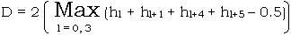
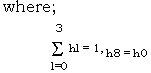
D = Feature of histogram
hi = the normalized value of flowing – water quantity
b) Texture
Texture analysis was accomplished by using co-occurrence matrix. Correlation and homogeneous has the best results in some parameters of texture. Also the results calculated from DEM of high frequency was better than ones from ordinary DEM.
Correlation

Homogenous

c) Histogram of slope Direction
Histogram of slope direction was calculated from terrain in the window are (50*50 pixels) where the target points located the center of window. Features of histogram was obtained by the same equation as the drainage pattern.
d) Terrain in small area
Terrain in small area was calculated for maximum gradient in small area (10*10 pixels)
Terrain in small area = (Maximum Height – Minimum Height) / Length
e) Terrain in large area
Terrain in large area was calculated for maximum gradient in large area (50*50 pixels).
Terrain in area = (Maximum Height – Minimum Height) / Length
f) Density of valley
Density of valley = Valley Area / Target Area
Size of Target Area are 10*10 pixels
3. Learning by Neural Network
Model of Neural Network utilized the back propagation model constructed by 3 layers. Input layer has 7 cells, Moderate layer has 40 cells and Output layer has 19 cells. The Signal data corresponding to each rock were generated by learning successively the feature calculated by supervised data. 16 types of pattern data were used for each area the learning was continued until the number of mismatching and the errors from supervised signal data were converged.
4. Calculation of the feat users in Target Area.
The features in study area were calculated by the same method as supervised area. Fig. – 2 shows the study area. Also Fig. 3 shows geological units of the area.
Figure 2. Study Area as Supervised Data
5. Pattern Recognition by Neural Network.
Probability was generated by neural network using features of study area.
6. Classification by probability of land form pattern.
Pattern of land form was classified by the probability generated neural network. The rock type of the biggest probability was determined as the representative of the area.
Results
Table -2 shows the results calculated by the supervised features. To check the sensitivity of each features for classification, the classification were performed by using some selected features.
Figure 3 Geological Map in Study Area
Figure 4 Classification Map by Drainage Pattern
Table – 2 and Fig. 4 show the results classified by the histogram of discharge and density of drainage. The result indicate as follows.
- Distribution of volcanic rock correspond almost to that of parallel pattern of drainage.
- Slate distributed are correspond almost to radiation pattern of drainage.
- Granite distributed area correspond almost to dendrite pattern of drainage.
Table 4 and Fig- 5 shows the results classified by terrain, slope direction of valley and texture, Area B, E have good correspondence to the distribution of slate, granite, respectively. Area C, D and G correspond all to the distribution of volcanic rock.
Figure 5. Classification Map by Trrain
Table – 5, Fig. 6, Fig. 7 shows the results classified by all features. Fig. 6 shows the result
Figure 6. Classification Map by all featuers(12 Units)
Figure 7. Classification Map by All Features(8 Units)
classified into 12 units and Fig. 7 shows the result classified into 8 units. The land forms were successfully classified and the segmented areas were well geological units. But the accuracy of granite distribution was worse than other units, because number of supervised area with granite is less than the others.
Conclusions
This study indicate that neural network is very useful to the classification of landform without threshold. Accuracy of classification depends on number, accuracy and potential of supervised data. But the result were good classification in spite of poor supervised data. classes of land form classification were good corresponding with geological units.
But it is found that this study have following subjects.
- Features of Land form should be modified by the weight functions, because each features has the difference scale.
- The rock type of the biggest probability was determined as the representative of the area. But the bigger probability less than biggest one were ignored in spite of the large probability. Therefore visualization method for fuzzy units should be developed.
- Inoki, etc., “Japanese Geology 7 Chugoku – Area”, Kyoritsu Press., 1987.
- A. Iwashita, etc., “Processing and Analysis of Imaging Data (2)”, ERSDAC, 1990.
- I. Kawaguchi, “Multiplication Analysis 2” Morikita Press, 1978
- M. Takagi, H. Shimoda, “Handbook of Image Process”, Univ. of Tokyo Press., 1991.
- T. Minami, “Imaging Recognition and Imaging understanding”, Keigaku Press., 1986.
- Mori, Itakura, “Fundamental of Imaging Recognition”, Ohmu Press., 1986.