| GISdevelopment.net ---> AARS ---> ACRS 1992 ---> Forestry |
Studies of the vegetation
change on the territory of Mongolia using AVHRR and Meteorological ground
data
Ts. Adyasuren, V.
Bayarjargal
National Remote Sensing Centre, State Committee
for Nature and Environmental Protection Ulaanbaatar – 11, Mongolia
National Remote Sensing Centre, State Committee
for Nature and Environmental Protection Ulaanbaatar – 11, Mongolia
Abstract
In this paper, a methodological approach to processing and application of AVHRR multiband information for pasturable vegetation state estimation of the Mongolian territory is given. Field measurements of grassland production in steppe zone of Mongolia over a period of 7 years are analyzed in conjunction with AVHRR data. The results demonstrate that there is a linear relationship between the satellite observations of vegetation indices and grassland production.
Introduction
The regular use of remotely sensed data in estimation of the natural pasture is one of the actual tasks in the field of natural object’s Remote Sensing.
If one consider these tasks from the point of view of estimation accuracy of the ‘soil-vegetation’ system, so they depend on used data and requirements, satisfying vital needs of users can be settled on various levels (regional, local etc). And because of that the more requirements are tough and high the more high must be resolution power of the information used for solution of such tasks, and this in turn brings to increases of temporal and material costs.
For operative estimation of the pasturable vegetation state more suitable information is that one received from the AVHRR satellite that has an adequate resolution for this purpose.
At present there are different methodological and technological approaches to the AVHRR data processing, connected with natural – climatic percularities and specific methods of agricultural management in this or that region, which are widely used in the world (Tucker, 1979, Lauritson L. etc, 1979, Adyasuren Ts, 1989, Adyasuren Ts, Ganzorig M, 1991)
In this paper is stated a methodological approach to processing and application of the above-mentioned information in solution of the given tasks in specific regional conditions of Mongolia.
Data and Methodology
1 Data
a. The AVHRR data tapes contain the calibrated information for all channels. The calibrated data for the channels 1 and 2 were used only for albedo percentage calibration.
b. Daily rainfall data records for 1982, 1983, 1984, 1975, 1986 and 1987 of the 25 meteorological stations in the whole territory of Mongolia for analysis.
2 Methodology
There are calculated several types of vegetation indices – normalized vegetation index, ratio and transformed vegetation index.
a. The Normalized Vegetation Index (NVI) is calculated with the use of mean reflectance values in the AVHRR Band 1 and Band 2.
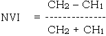
Where, CH1 is the AVHRR channel 1 response and CH2 is the channel 2 response.
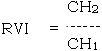
b. The second vegetation index called “Ratio Vegetation Index” (RVI) given by:
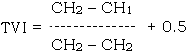
d. Transformed Vegetation Index (TVI) is calculated
Results and discussion
1 The relationship between the biomass and spectral reflectance of pasturable vegetation Fr searching indicators of the sensitive spectral characteristics related to the biomass dynamics of the steppe pasturable vegetation were used the above spectral reflectance combinations.
The results of the correlation analysis between the spectral reflectance combinations and dry, wet biomass of the pasturbale vegetation were given in the table 1.
| Types of the systems“Soil Vegetation” | Bio-mass state | Combinations of the spectral reflectance characteristics | ||||||
| Rk | Ruk | Ruk/Rk | VI | Ruk+Rk | RUK+Rk/ Ruk-Rk | TVI | ||
| 1. Mountain meadow with various grasses – Carex fine turt Cereals and Cereals in Dark-chestnut soil; | Wet Dry |
-0.83 0.88- |
0.79 0.78- |
0.89 0.92- |
0.89 0.93- |
0.21 0.16- |
0.72 0.72- |
0.88 0.88- |
| 2. CLEISTOGENESSTIPA with CARGANA; | Wet Dry |
-0.62- 0.92 0.63 0.83 |
0.14- 0.72 0.08 0.77 |
0.77- 0.78 0.74- 0.75 |
0.87- 0.88 0.83- 0.88 |
0.62- 0.70 0.72- 0.62 |
0.78 0.83 0.81- 0.81 |
0.87- 0.90 0.86- 0.88 |
| 3. Fine turf CREEALS –STIPA with ANEURO – LEPIDIUM PSEUDOAGROPYRUM | Wet Dry |
- - 0.88 |
- - 0.47 |
- 0.94 |
- 0.91 |
- - 0.24 |
- 0.86 |
- 0.09 |
| 4. Varions grasses STIPA in stony chestnut and dark chestnut soils | Wet Dry |
-0.56- -0.73 0.58- 0.92 |
0.02- 0.67 -0.64 0.63 |
0.78- 0.99 0.83- 0.98 |
0.78- 0.95 0.81 0.96 |
-0.10- -0.44 -0.16- - 0.76 |
-0.39- -0.72 -0.39- 0.20 |
-0.78- 0.93 0.64- 0.95 |
| 5. Eastern Gobi Plateau with Mongolian onionspecies (ALLIUM MONOGLICUM Rgl.) | Wet Dry |
-0.70 - 0.80 |
-0.29 - 00.47 |
0.82 0.87 |
0.82 0.86 |
- 0.57 - 0.71 |
0.60 0.49 |
0.58 0.56 |
The figure in Table 1. show than more higher correlation coefficients were derived for such indices as the ratio of the spectral reflectance e coefficient (SRC),. NVI and TVI to the biomass.
But the correlation coefficients of the remaining spectral contrast indices not better in near infrared and red bands separately in comparison with SRC. A regression method was used for the study of pasturable vegetation using Remote Sensing at the given stage of the experimental data processing.
In the study as the dependent variables were taken those combinations of spectral reflectance of which the correlation coefficient with biomass were higher than in case when the spectral reflectance coefficient taken in individual spectral bands.
In the Fig. 1 reflecting the calculation results one can notice that the ratio’s values of the spectral reflectance coefficient in Near infrared bands to the SRC in Red bands and NVI are were increased with the biomass increases of the arid steppe pasturable vegetation.
The use of simple linear functions for these vegetation cover types gives the results satisfying resolution of the set tasks.
From the study a conclusion can be drawn that the above indices of the spectral reflectance combinations viz., ratio of SRC in NIR bands to Red bands and NVI are more sensitively for determination of the biomass state of the arid steppe pasturable vegetation in Mongolia.
Consequently, such an approach can facilitate the potential possibilities in selection of the same spectral combinations which are sensitively to the other parameters characterizing the state of the natural pasturbale vegetations.
2 Relationship between vegetation index and weather condition
If we analyze the calculated combinations of the spectral reflectances. It has been obvious that there was revealed a better correlation between vegetation biomass and the normalized vegetation index and also a linear regression was derived.
The established of the interrelation of NVI and the weather condition by this relationship should be as basis for assessment of droughtness and in a vast territory using Satellite data.
The calculated correlation between the vegetation index and rainfall is presented in table 2.
| Year RR |
1982 0.796 |
1983 0.769 |
1984 0.816 |
1985 0.880 |
1986 0.687 |
1987 0.839 |
The table 2 shows that better correlation (RR>0.68 – 0.88) between NVI and rainfall has been obtained
Therefore, regression scheme of NVI with total rainfall was created and shown in Fig. 2 From the regression analyses can be noticed that 10985 – 1987 period of abundant rainfall and better condition of Spring – Summer grassland is related to NVI higher values and in rivers scanty rainfall with poor grassland state to NVI lower values.
Fig. 2. Relationship between the NOAA AVHRR combinations valus 16 X 16 pixel blocks for spring - Summer and rainfail totals for 1 apr. to 31 aug.
If we compare the above conclusion with NVI spatial distribution map and HMRI Drought map :
From HVI map can be seen that average values for an entire Mongolia in 1982-1984 were 0.15 – 0.18 and territory with values below 0.10 occupied 29-31 per cent. Hence, 20-29 per cent of the territory were with 0.10 – 0.15 unit values of NVI.
During the spring summer period in these territories fell of 2.4 – 87.0 mm rainfall i.e. in average of 45 – 50 mm. But NVI higher values were not exceeded once in 1982, 3 times in 1983 and 7 times in 1984. This means that in these years the majority of the territory was droughty and with poor grassland (Scanty vegetation). In 1985 – 1987 summer vegetation state was improved and average NVI values in the entire territory were exceeded over 0.20 NVI values went down below 0.10 on 15 – 23 per cent of the whole territory and there fell 17.6 – 86.7mm i.e., in average 60 – 70mm rainfall.
According to the Drought Map of the whole territory 35 per cent in 1985, 43 per cent in 1986 were droughty and arid in 1987 grassland state was better.
But in this period NVI higher values 8 times in 1985, 1986 and 1987 were above 0.28 that indicated summer grassland state was well.
Conclusions
As a result of the study the following conclusions can be drawn out :
- Spectral reflectance NVI; RVI; TYI combinations are more suitable for Remote Sensing of the pasturable vegetation state in brown soil area of Mongolia;
- The possibility of operational estimation of pasturable vegetation state and its dynamics on a vast territory using NVI; RVI ratios between CH1 and CH2 of the NOAA satellite AVHRR data on the basis of close relationship between SRC and vegetation biomass has been revealed.
References
- Tucker C.D Red and Photographic Infrared Linear Combinations for monitoring vegetation Remote Sensing of Environment., 1979, v.8. p. 125-150.
- Luaritson L., Nelson G.J. Porto F.W. Data Extraction and calibration of TIROS-N/NOAA Technical Memorandum Ness 107; NOAA National Environmental Satellite Service, Washington, D.C, 1979.58 P.
- Graets R.D. Satellite Remote Sensing of Australian Rangelands – Remote Sensing Environment, 1987, V.23, N 2, P. 313-332.
- OVAAS-8 Image Processing System, 2PAAC Users Manual, Ontario, 1983 39 p.
- Adyasuren Ts. Method and Technology of Remote Sensing in Pasture Grassland state Estimation for Dry-Steppe Region of Mongolia – Dissert. For a Degree of Dr. of Techn. Sc. (in the Mongolian lang.) Ulaanbatar, Mongolia, 1989 p. 143.
- Adyasuren Ts., Ganzorig M. The use of AVHRR Data in Natural Grassland Estimation in the Steppe Pasture zoen of Mongolia. – Asian- Pacific Remote Sensing Journal, 1991, v.3., N 2, p. 25-32