| GISdevelopment.net ---> AARS ---> ACRS 1992 ---> Earth Environment |
Global Mapping for Global
Environment
Hiroshi
Masaharu
Planning Department, Geographical Survey Institute, Japan
Planning Department, Geographical Survey Institute, Japan
Abstract
A plan to prepare one millionth scale maps covering whole ground area of the earth (Global Map) is proposed for grasping global environmental conditions. An international organization should be established for this project.
1. Introduction: --- why Global Mapping Now?
Global change, such as global warming, deforestation, desertification and acid rain, is now widely recognized as one of the most important issues imposed on mankind, demanding urgent countermeasures. TO solve these problems, it is essential to grasp the present situations of global environment. Since most information on environment is related to geographical position on earth surface. maps with standardized specifications and precision covering the whole world ( Global Map) would be a basic information infrastructure for research and policy making on global environmental problems. Global maps themselves would also provide information needed to understand and analyze environmental conditions; for example, distribution of forests, residential area, road, vegetation, rivers, lakes, marshes, desert, and so forth are delineated on them.
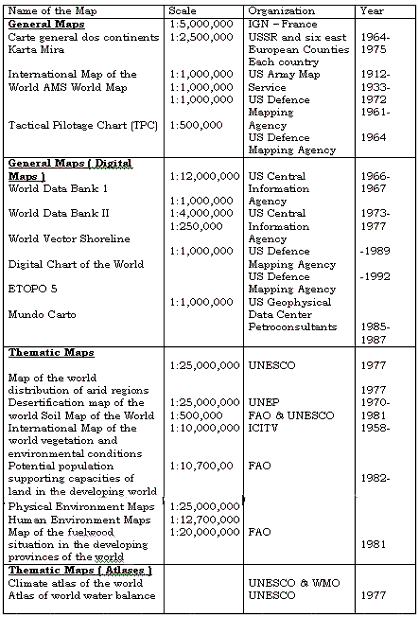
Several attempts have been made among the international cartographic communities for global mapping. United Nations Cartographic International Map of the World on the Millionth Scale (IMW). Many countries started to prepare IMW following these resolutions and have accomplished most of the coverage by the end of the 1960,s. Many of these one millionth scale map have been kept unrevised since then. attempt can be attributed to the fact that individual countries of different financial background were responsible for mapping their own territories.
According to "World Cartography XX" (United Nation 1990) 1) 33.3% of the world is covered with maps at the scales of 1:25,000 or larger and 90.2% is covered by 1:250,000 scale range . These figures might be considered that most of the world is already covered with medium scale maps. But in reality some of them are very old and have not been well revised. Furthermore specifications and precisions of the maps are not uniform because they have been made by each country. The conditions make it difficult to extract up-t0o-date and reliable environmental information out of the maps, and inconvenient to use them as base maps for plotting information from other sources. Consequently, the present world does not have 'Global Map' to cope with the global issues. In addition, even existing maps are not always available to the general public and foreign researchers because maps are still considered secret in some countries
The Cold War, however, has ended, and there is little reason to consider maps as a confidential property of each country. Furthermore, commercially available high resolution image data from satellites have removed the military secret tags from maps of small scale.
Recent development of satellite remote sensing technology has also made it possible to make medium to small scale maps using satellite imagery. This provides the technical basis for Global Mapping through international cooperation. Consequently, we do not have any political or technical obstacles to accomplish Global Mapping, and now is the best time to realize this huge project to save the earth from environmental devastation.
The objective of this paper is to propose a plan to make Global Map under international cooperation. The Geographical Survey Institute, Japan (GSI) carried out intensive study on the role and possible contribution of surveying and mapping organizations to global environmental problems in 1990. The results of the study were published in a report. 2) The plan of Global Mapping has been developed based on this study.
2. Proposal of Global Mapping
The Geographical survey Institute and the Ministry of Construction of Japan have worked out a plan of Global Mapping to be proposed to international community. 3) This project should be carried out through close international cooperation and the plan is a draft proposal to be further improved through discussions among professionals.
2.1 What should be made as the Global Map?
The plan is to prepare maps of the whole ground surface of the earth on one millionth scale both in digital and in analogue format within about five year.
The selection of map scale determines the character of the map. The reason we selected one millionth scale is that at smallest one millionth is necessary t represent important ground feature in actual shape to grasp environmental conditions. Administrative boundaries of smallest unit such as village can be delineated with noticeable area on one millionth maps. This is necessary to plot statistical data one maps for sociological analyses and policy making.
Another reason is that most fundamental thematic information related to environment such as geology, vegetation, soil and hydrology is available from existing sources in one millionth scale. Consequently, we can make one millionght thematic maps in the second stage of the Global Mapping. These thematic maps with unified specifications will greatly contribute to the understanding of the global environmental conditions.
One millionth scale is also convenient when plotting grid data on maps because one kilometer on the ground corresponds to one millimeter on the map. The digital data of the Global Map can be used for various numerical simulations.
One the other hand, preparation of 1:200, 00 scale maps globally needs much more time and cost. Considering urgent necessity of unified maps of the whole world, we selected one millionth for the first stage of the Global Mapping project,
One may think new mapping on millionth scale is unnecessary because there already exist one millionth scale maps covering whole world such as Operational Navigation Chart (ONC) and World Map by Army Map Service (AMS). But ONC is a thematic map for aeronautical navigation and therefore the representative of ground features is not minute enough for one millionth scale. AMS maps are rather old. Therefore we consider it is necessary to make new one millionth scale maps. It is needless to say that when making the new maps we should make use of existing reliable resources as much as possible.
In our plan, the Global Map should contain the following entities; ground elevation, shorelines, rivers, lakes, marshes, vegetation, deserts, dunes, residential areas ( villages, towns, cities ), roads , railways, administrative boundaries and geographical names. The Global Map can be used as a general map and also as a base map for plotting other information. It is also possible to extract various kinds of environmental information from the map alone and to make out environmental conservation plan or development plan cover classification information. We can recognize environmentally important features by map reading and emphasize them by changing their map representation or draw boundary lines around them.
2.2 How to prepare the Global Map?
2.2.1 Technical Aspects
The Global maps will be made by compiling existing maps and geographical information resources where available. If there are no appropriate maps, satellite imagery will be employed. For example, ground elevation is measured by using stereo pairs of SPOT satellite imagery. SPOT imagery is also used to delineate ground features. Other earth observation satellites which acquire stereo imagery can also be used besides SPOT. For land cover interpretation, imagery of Landsat or other satellites also can be employed. Making maps from satellite imagery has nowadays become well-established technology. (See Appendix.)
Digital cartographic data will be made by manual or automatic digitization of existing maps or compilation of existing digital data. For the areas where new mapping is required for the Global Map, the direct digital mapping technique will be employed. Geographical names will be collected in cooperation with surveying organizations of each country.
2.2.2 Organizational Aspects
Preparation of the Global Map should be done from its nature in close international cooperation. Up to now mapping has been carried out by each country. For example, preparation of IMW was recommended by UN Cartographic Conferences, but the preparation itself had to be carried out by each nation. However the preparation of the Global Map within short period of time would be impossible in this manner because many of developing countries suffer from lack of fund and techniques. Therefore we proposed establishment of an international organization which prepares and distributes Global Map. It will be operated by donation from countries, and play the role of global geographical data center which provides and distributes the Global Map including digital cartographic data to international community.
In preparing the Global Map, the organization will entrust the task partly to private surveying companies under contract and partly to national surveying and mapping organizations. By utilizing manpower of each country's surveying organization and bearing the cost of production by the international organization, he preparation of the Global Map will be conducted in the most effective manner. In addition, providing technical assistance to developing countries will also be an important role of the organization.
Appendix Mapping using satellite imagery
The number of earth observation satellites with the capability of acquiring stereo imagery of the ground is increasing. JERS-1 ( renamed to FUYOU-1 after launching ) was successfully launched in 1992. The OPS sensor loaded in the satellite is a line scan optical sensor with forward and nadir looking sensor arrays producing stereo imagery. SPOT satellite, the first one with stereo imaging capability from different orbit path, has long been used and application software's for stereo plotting of SPOT imagery are already on the market.
Ministry of Construction, Japan conducted a study on making maps from SPOT imagery from 1987 to 1991 in cooperation with Instituto Geographico Nacional, Peru. 4) The results of the study are summarized here.
The accuracy of height measurement from SPOT images was about G meters in RMS error and about 25 meters in maximum error for flat terrain. For mountainous regions, errors increased to about 10 meters RMSE and abut 60 meters maximum. By comparing contour lines with those of existing maps, it was concluded that 40 meter interval contours can be drawn from SPOT data.
The study on image interpretation showed that (1) rivers and shorelines were very clearly visible. (2) roads were sometimes difficult to identify depending on image tone. (3) railways were rather difficult to recognize. and (4) urban areas could be easily distinguished from suburban.
As a conclusion 1:100,000 topographic maps can be made from SPOT images with modified map specifications and supplementary ground survey.
Considering above results, one millionth scale maps with 100 meter contour interval can be made from satellite imagery with sufficient accuracy if supplemented by other sources from linear objects ( railways, narrow but important roads ) which are sometimes difficult to identify on satellite imagery.
Acknowledgments
The author wishes to acknowledge his debt to the staffs of the Geographical Survey Institute and the Ministry of Construction for making the plan of Global Mapping , and also wishes to express special thanks to Mr. H. Murakami for his many valuable comments on this paper.
References
- United Nations, World Cartography Volume XX, 1990, pp. 148
- Geographical Survey Institute ed., Image Survey --- Tasks in Surveying and Mapping Field to copy with Global Environmental Problems, 1991, pp , 298. Printing Bureau, Ministry of Finance, Government of Japan ( in Japanese )
- Geographical Survey Institute and Ministry of Construction, Global Mapping, 1992 ( brochure)
- Ministry of Construction and International Engineering Consultants Association, Final Report of the Joint Research Project for the Development of the Mapping Method using Satellite Data, 1991, pp. 220 ( in Japanese: Spanish version is also available )