| GISdevelopment.net ---> AARS ---> ACRS 1992 ---> Digital Image Processing |
An Attempt to Observe Paths
of Particle of Wind Flowing over Buildings Utilizing Simplified Aerial
Photogrammetry
Wu Jianping
Department of Geography, East China Normal University, Shanghai, China
Department of Geography, East China Normal University, Shanghai, China
Abstract
Decomposition of mixed pixels is an important way to improving Remote Sensing information representation. Many scientists have discussed the theories and methods about it. This paper describers fuzzy supervised and fuzzy unsupervised classification methods to decompose the mixed pixels. A Landsat TM subimage of a county is extracted for experiments and their accuracy are analyzed by area ratio which compares the area of every landuse in a region from fuzzy classification and from measure of aerial photograph.
Mixed pixels exist extensively in scanning remote sensing image. It is estimated that NOAA image (1.1*1.1 km2) of meterological satellite have more than 90 percent mixed pixels in land part, MSS image (80*80 m2) of Landsat have about 70 percent, and TM image (30*30 m2) of Landsat have about 50 percent, even though the resolution of an image reaches 5*5 m2, there are more than 30 percent mixed pixels. If the mixture cannot be taken into consideration in using and processing remote sensing data, the expressive limitation will reduce the classification accuracy level and lead to the poor extraction of information.
Decomposition of mixed pixels is an important way to improving Remote Sensing information representation. Currently, there are two basic methods about it: 1) fuzzy classification method (1) 2) establishment of relation pattern between spectral response of a pixel and spectral response and area proportion of every elements in the pixels. (2)
Fuzzy Classification Method
In traditional classification, information is represented in a one-pixel -one - class method and its classification result is definite, i.e. a pixel belongs to a class. In fuzzy classification, a pixel is considered having different membership grades obtained from fuzzy classification indicate the area proportion of every cover classes in a mixed pixel. As the traditional method, the fuzzy classification can also be divided into fuzzy supervised and fuzzy unsupervised classification.
Fuzzy Supervised Classification
Sample pixels should be chosen for estimating fuzzy parameters before classification, different to conventional method, chosen sample need not be sufficiently homogeneous. Fuzzy mean can be expressed as
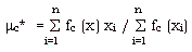
where n is the total number of sample pixels, fc is membership of a pixel to class c, xi is pixel value of sample pixels. Fuzzy covariance matrix can be expressed as
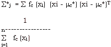
After the fuzzy parameters are determined, every pixel is classified according to its spectral value. To perform a fuzzy classification, the membership function must be defined for each class, in this work, the membership functions are defined based on maximum likelihood classification algorithm with fuzzy and fuzzy covariance matrix replacing the conventional mean and covariance matrix. The following is the definition of membership function for cover class c:
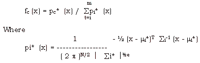
N is the pixel vector dimension, m is number of predefined classes.
Fuzzy Unsupervised Classification
The fuzzy unsupervised classification can be performed in many methods, in this work, k-means clustering algorithm is adopted and is run using iteration as following:
- determine classification number k, 1
- give a initial membership matrix

- calculate fuzzy clustering where centers of every class
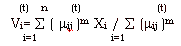
- calculate new membership matrix U(t+1) using formula
- if the criterion is satisfied, stop the iteration. Otherwise, repeat process 3 to 5. The criterion of ending iteration can choose
- give a initial membership matrix
The fuzzy classification algorithm has been applied to Landsat TM data. Encouraging results have been achieved in identifying types and proportions of component land covers in mixed pixels.
Jiadin county, northwest of Shanghai, China, is chosen as a study area which covers 483.75 km2. Five cover classes are defined for the classification they area farm land, forests of woods, residential or industrial area, communication land and water body. Five TM images (band 2, 3, 4, 5, 7) are used in the classification.
A digital boundary map is overlaid upon the TM image with control points and a subimage whose pixels lie in the county is extracted. The subimage has 604687 pixels and these pixels are decomposed using fuzzy supervised and fuzzy unsupervised classification. The total area of every class in the county can be calculated through multiplying the sum of membership of every pixel to the class by the ground area of a pixel which is the ratio of total ground are to total pixel number in the county.
The accuracy is assessed by using area ratio,
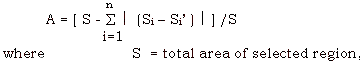
where
S = total area of selected region,
Si = are of class I from the result of the classification
Si= are of class i from aerial photograph measure in same region, the photography was taken in near time with TM image,
n = number of classes, 94.52 percent and 95 overall accuracy have been measured from the results of the fuzzy supervised and fuzzy unsupervised classification. Table 1 shows the result.
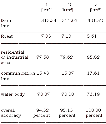
1 = fuzzy supervised classification
2 = fuzzy unsupervised classification
3 = measure from aerial photograph
90.40 percent and 91.81 percent overall accuracy are measured from the result of the conventional classification table 2 shows the result.
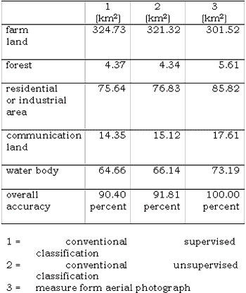
Table 1 and table 2 show accuracy improvement of 4. 12 percent and 3. 34 percent respectively have been achieved.
Reference
- Fangju Wang, Improving Remote Sensing Image Analysis through Fuzzy Information Representation. Photogrammetric Engineering and Remote Sensing, Vol 56, No. 8, 1990, 1163-1169.
- Y.E. Shimabukuro, and J.A. Smith, The Lest-Squares Mixing Model to Generate Fraction Images Derived from Remote Sensing Multispectral Data. IEEE Trans. On geoscience and Remote Sensing, Vol. 29. No. 1, 1991, 16-2-.