| GISdevelopment.net ---> AARS ---> ACRS 1992 ---> Agriculture |
Disaster Monitoring using
Remote Sensing and Ground Data in Mongolia
M. Badarch, L.
Natsagdorj
National Remote Sensing Centre
State Committee for Nature and Environmental Control
Ulaanbaatar, Mongolia
National Remote Sensing Centre
State Committee for Nature and Environmental Control
Ulaanbaatar, Mongolia
Abstract
Mongolia, a developing country with few population has been constantly stricken by various severe disasters including droughts, earthquakes, weather, storms, floods, hailstones, events took away lives and properties. Statistics snowed that every year various natural disasters in Mongolia kill people and livestock, destroy farmland, burn forest. For example, in April 1980 in the Eastern part of the Mongolia has been observed strong snow storm. During of this snow storm (41-65 hours of continuation) killed 150 people and 0.6 million livestock and results in about many million turgrics worth of economic loss. One potentially proven tool in natural events and disaster monitoring and damage proven tool in natural events and disaster monitoring and damage assessment is Remote Sensing technology.
Environment satellites such as NOAA, GMS with ground observation system afford a global overview on natural disasters, and is a powerful tool for decision makers as early warning systems.
In this paper, we present some results of natural disasters monitoring using Remote Sensing and ground data in Mongolia.
Introduction
The critical factors distinguishing natural phenomenon from natural disasters are loss of life an property. Certainly, humans cannot prevent the occurrence of natural phenomenon, such as snow and dust storms, hurricanes, severe drought and snow cover on large area, however, their disastrous effects can be lessened significantly if well conceived disaster response plans and mitigation strategies are in place prior to their occurrence.
The United Nations General Assembly, at the 42nd session in December 1987, passed a resolution designating the 1990s as International Decade for Natural Disaster Reduction (DNDR). As man as 93 countries expressed their support for IDNDR. The objective o the initiative is to reduce loss of life, property damage, and social and economic disruption caused by natural disasters through concerted international efforts.
The goals are to: 1. Improve the capacity of each country to foresee natural disasters by the establishing early warning systems. 2. Foster science aimed at closing critical gaps in the knowledge to reduce natural disasters. 3. Disseminate existing and new information related to the assessment, prediction, prevention and mitigation of natural disaster. 4. Develop measures for the assessment, prediction, prevention and mitigation of natural disasters through various modalities and demonstrationact from satellite and ground data specific types of information related to natural disasters in Mongolia is the most important task.
To develop mitigation measures and appropriate preventive actions, it is necessary to have Remote Sensing and ground data on the various processes related to atmosphere and earth resources in Mongolia.
The Mongolian Government has come to appropriate the growing importance of combating natural disasters with aid of satellite system such as JEST-1, Landsat, Spot, NOAA, GMS. However, a number of limiting factors, including cost of Landsat and Spot data hinder the full utilization of these capabilities. Consequently, Mongolia uses only NOAA and GMS for natural disasters. The use of current word existing space system in disaster mitigation of current word existing space system in disaster mitigation and relief is important for a developing country like Mongolia.
1. Drought
Drought is one kind of the natural disaster in Mongolia. In Mongolia there are several existing research projects on the causes of drought, some of which have already published results (Mijiddorj. R, Namkhai. A and Mend.S, 1985). Several criteria have been used for studying the causes of drought in Mongolia. The most effect have been Si criterion (Ped. D. 1975), which used a combination of temperature and relative humidity at 12 O’clock of the day reflecting a drought event within a month.
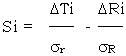
here, DTi, DRi, are anomalies of temperature and monthly or seasonal precipitation respectively; sr sR standard deviation respectively.
In order to measure the severity of drought, the following criteria are used :
On an average, statistics for the 50 years indicate that severe drought for all of Mongolia occurred only once (in 1944). Severe drought for 75 percent of Mongolia occurred once every two years. Severe drought in some part Mongolia occurs every year. Figure 1, shows the extent of the severe drought that occurred in Mongolia in 1965.
![]()
Figure 1 Drought map of Mongolia that occurred in summer, 1965.
1. Good overwetting area.
2. Overwetting area. (normal condition)
3. Moderate drought area
4. Severe drought area
The National Remote Sensing centre of the Mongolia has developed the methodology to estimate drought severity using the satellite and ground data. figure 2, shows the drought maps in Mongolia which occurred in May and June of this year.
![]()
Figure 2. Map of drought in May-June, 1992
2. Forest and Steppe Fires
About 10% of the land surface of Mongolia, equivalent to some 15,000,000 ha, are covered by various types of forest. Larch, pine, and birch forests dominate in the northern part of the country and sexual (haloxilon) forests are most common in the arid / semiarid part of Mongolia, accounting for 28% of total forest cover.
These forest resources traditionally provided a sufficient timber and fuel wood supply for the population and contribute about 10% to the GNP of Mongolia, accounting for 28% of total forest cover.
These forest resources traditionally provided a sufficient timber and fuelwood supply for the population and contribute about 10% to the GNP of Mongolia. Recently, the Government of Mongolia has realized the ecological value of forests. To further protect these value of forests. To further protect these valuable resources, export of timber have now been banned.
Protection of forest from fire and insect Attack remains a major concern.
About 10 000 to 14 000 ha of forests are cleared annually, where as only 5 000 ha are reforested an another 5000 to 6000 ha are left of natural regowth, this resulting in a net loss of forest resources which is further increased by frequent forest (about 100 000 to 150 000 ha annually, i.e. ten times the harvested area) and other calamities. In April 1986, a single fire caused a damage of about 3.5 million US $ and killed 18 people.
Forest fires pose a serious threat to Mongolian forests. More than 90% of reported fires are caused by human carelessness (or intension). The cause of the other remaining fires is unknown.
The loss to the economy of the country should not be counted only in cubic meters of wood because larch and pine often survive a ground fire due to their thick bark. An even more devastating effect in the long term is that natural as well as man-made reforestation is wiped out by the fire. An area hit by fire in 10-15 year intervals of more often, will never get any surviving regowth of the main species.
The reported forest areas burnt in the last 25 years are plotted in the graph in Figure 3.
![]()
Figure 3. Forest area burnt per year
In 1963-85 an overage of 1,54,000 ha per year were reported as burnt. Compared to the annually logged area of 12-15,000 ha, the magnitude of the destruction in April of 1986 is obvious.
The biggest fire occurred in April of 1986 in the eastern part of the Mongolia. A lightening-caused fire completely destroyed many local dwellings. Due to extreme dryness and strong winds the fire spread rapidly over 12 (somons) in the Dornod and Khentei districts (aimaks). Out of 75 victims in the fire, 18 people died, 107 families were left homeless. 1100 thousand hectares of valuable pastures and 7,326 stacks of stored hay were burned, 133 animal shelters were destroyed, and more than 55,000 head of cattle were killed.
The fire severely damaged local forests reserves. Still now the fire prevention and fighting capabilities in Mongolia are very low. There are 15 fire observation towers covering one-third of the whole forest area.
The national Remote Sensing Centre of the Mongolia has recently developed fast and cost efficient methods to analyze NOAA satellite Remote Sensing data for regional scale fire detection and monitoring. This methodology is using by the national Remote Sensing Centre of the Mongolia, which operates its own NOAA receiving station. In addition many types of forest diseases and calamities can detected using high resolution satellites data.
Figure 4, Shows the forest burned area of the Mongolian territory in May and June 1992. This figure shows the lush north slopes of the Khangai mountains, areas in eastern Mongolia, and Orkhon-Selengyn are now marred by huge black spots, testament to Mongolian’s worst forest fire. For this two month occurred 157 cases observed the forest and steppe Fires on the territory of Mongolia and were burned 1,456.200 ha forest and steppe (349.7 ha forest, 1,066,200 ha steppe).
![]()
Figure 4. Forest and steppe grassland area burnt in May-June, 1992 obtained using NOAA satellite data
The Government of the Mongolia is making efforts to help improve fire prevention techniques. For this purpose need to establish in the future the forest fire prevention system in Mongolia and decide special fund for fire prevention work.
3. Land degradation
Among Mongolia’s most serious environmental disaster problems is soil erosion. In part, it has natural causes (e.g., low annual average rainfall, low temperatures and high temperatures fluctuations, all of which help account for sparse vegetation, its easy disruption and slow subsequent recovery). Winds tend to be at their peak during the driest season, while the period of maximum rainfall (April-May) tends to coincide with the minimum density of vegetation. The result is that most of the country is considered eroded to some extent due to wind, water or both.
The impact of human-caused soil erosion has been equally serious and not limited to cultivated land. Thousands of hectares of pasture lands surrounding the approximately 40,000 wells installed in and semi-arid areas have been degraded. The poor condition of country roads and resulting practice of driving off-road on natural terrain, too, has caused drivespread erosion impoverishment of the pasture species composition.
4. Snow and dust storms
Snow and dust storms are natural disasters which are very dangerous for husbandry and transport. Atmospheric disasters such as blizzards and snow storms occur in Mongolia about 20 times per year. The during of the snow storm killed many thousand animals and people. For example, For example, in April 1980 in the Eastern part of Mongolia has been observed strong snow storm. During of this snow storm (41-65 hours of continuation) killed 150 people and 0.6 million livestock and results in about many million tugrics worth of economic loss. Figure 5, showed the number of days with snow storm on the territory of Mongolia.
![]()
Figure 5. Map of number days with snow storms in Mongolia
Dust storms are especially common in Mongolia in the Spring, affecting normal pasturage management (Cattle [pasturage is stopped due to strongly wind and dust) and aggravating soil erosion processes.
Studies have revealed that dust storms occur in southern Mongolia 20-30 days each year. In particularly bad years these storms can last up top 350 hours. During the past 30 years the number of dust storms in the Gobi area has increased 2 times. One of the biggest storms occurred in the Gobi area in November of 1992. Wind speed during this storm reached 40m/sec, flattering over 500 gers, hundreds of animal shelters, and ripping off roofs, and breaking window. In addition, 51,000 square kilometers of the pasture area were destroyed. Direct economic loss from this one storm reached several billion tugrics. Figure 6, shows the extent of this dust storm. The above figure was obtained by ground and satellite data.
![]()
Figure 6. Map of storm wind speeds from November, 1992 obtained using satellite and ground data
Also dust storms cause air pollution in east Asian countries in the spring. For example, dust clouds stirred up in storms over the Gobi area affect even far-away Japan. Called “Kosa,” these clouds are polluted ground and surface water in Japan. This problem will be investigated in the future using satellite and ground data.
5. Snow cover
The whole territory of the Mongolia is very prone to snow disasters. Snow disasters investigation and prevention in Mongolia has been a primary application of the Remote Sensing technology.
The southern snow cover boundary in the northern hemisphere passes through Mongolia. Therefore, the territory of the Mongolia is key to snow cover assessment and monitoring in Central Asia. The economy of Mongolia has been seriously threatened by snow cover disasters. In Mongolia, snow cover significantly affects the development of the national economy, especially in the case of cattle breeding. Substantial snow cover is a food indicator of adequate pasture vegetation supply in springtime and adequate water supply for husbandry in both winter and spring. At same time, however, snow depths and density that exceed due to grass being buried under the snow cover. Some years deep snow cover kills thousands of cattle. Satellite data is an invaluable tool for evaluating the cattle pasture situation for country need satellite and ground data. Also during the relief period, such data can be used to transmit relief requirements and provide medical advice to under-trained or over –earned personnel at the site. For these reasons, the National Remote Sensing Centre has developed the method of the mapping snow cover distribution by satellite and ground data. (M.Badarch, 1990, 1991).
The criteria of the influence snow cover on the cattle pasturage has been developed using ground and satellite data (Tuvaansuren. D, 1984). The criteria of influence of snow cover on cattle pasturage for small and big animals were developed. These criteria are obtained by measuring snow cover data and observing the behaviour of the animals during the eating time. The measurement of snow cover and observation behaviour of animals are made at the same time in the chosen pasturage areas. When snow depth, and density reach and exceed 8cm and 0.22kg/cm3 respectively in steppe and Gobi areas, it has been observed that cattle pasturage for small animals becomes considerable difficult. When the above mentioned snow values reach and exceed 13cm and 0.26g/cm3, cattle pasturage stops. If the above weather conditions continue for several days, small animals begin to due not no fodder.
Using the criteria to predict snow cover’s affect on big animals (cows, horses) is different. When snow depth and snow density reach and exceed 18 cm and 0.22g/cm3, big animals have considerable difficulties reaching the grass below. When the above snow characteristic reach and exceed more then 40cm and 0.35g/cm3 big animals pasturage stops.
6. Flood
Two kinds of floods occur in Mongolia: snowmelt flood (spring time) and floods due to heavy summer rains. Seasonal snow cover is also of critical importance in mountainous areas, since the rapid melting of snow can cause flood disasters.
To develop the methodology of snowmelt flood forecasting, the digital data from the operational NOAA meteorological satellites is used. To use snow cover run-off models, satellite data is used to determine the extent of snow coverage in watersheds and snow line elevation. The satellite data interpretation and comparison with other sources of information are done by methods which can be divided into: geometric normalization, radiometric normalization, recognition of studied objects within images/image data/, and quantification of recognized objects. Within the data processing, the method depends on data type and on algorithms used for individual processing steps.
Furthermore, the methodology of short and long term rain flood forecasting has been developed and used (Dashdeleg.N, 1987) for the rivers of the Selenge River Basin using meteorological satellite data. This methodology is based on the relationship between rain flood volume and the cyclone intensity by which a flood was caused.
Conclusion
Disasters in Mongolia are so damaging because the resources for prevention, mitigation and preparedness are so limited. Therefore, the development of the new methods and computer and Remote Sensing science based modern technology for long and short term forecasting the natural disasters in Mongolia is actual scientific task.
References
Mongolia, a developing country with few population has been constantly stricken by various severe disasters including droughts, earthquakes, weather, storms, floods, hailstones, events took away lives and properties. Statistics snowed that every year various natural disasters in Mongolia kill people and livestock, destroy farmland, burn forest. For example, in April 1980 in the Eastern part of the Mongolia has been observed strong snow storm. During of this snow storm (41-65 hours of continuation) killed 150 people and 0.6 million livestock and results in about many million turgrics worth of economic loss. One potentially proven tool in natural events and disaster monitoring and damage proven tool in natural events and disaster monitoring and damage assessment is Remote Sensing technology.
Environment satellites such as NOAA, GMS with ground observation system afford a global overview on natural disasters, and is a powerful tool for decision makers as early warning systems.
In this paper, we present some results of natural disasters monitoring using Remote Sensing and ground data in Mongolia.
Introduction
The critical factors distinguishing natural phenomenon from natural disasters are loss of life an property. Certainly, humans cannot prevent the occurrence of natural phenomenon, such as snow and dust storms, hurricanes, severe drought and snow cover on large area, however, their disastrous effects can be lessened significantly if well conceived disaster response plans and mitigation strategies are in place prior to their occurrence.
The United Nations General Assembly, at the 42nd session in December 1987, passed a resolution designating the 1990s as International Decade for Natural Disaster Reduction (DNDR). As man as 93 countries expressed their support for IDNDR. The objective o the initiative is to reduce loss of life, property damage, and social and economic disruption caused by natural disasters through concerted international efforts.
The goals are to: 1. Improve the capacity of each country to foresee natural disasters by the establishing early warning systems. 2. Foster science aimed at closing critical gaps in the knowledge to reduce natural disasters. 3. Disseminate existing and new information related to the assessment, prediction, prevention and mitigation of natural disaster. 4. Develop measures for the assessment, prediction, prevention and mitigation of natural disasters through various modalities and demonstrationact from satellite and ground data specific types of information related to natural disasters in Mongolia is the most important task.
To develop mitigation measures and appropriate preventive actions, it is necessary to have Remote Sensing and ground data on the various processes related to atmosphere and earth resources in Mongolia.
The Mongolian Government has come to appropriate the growing importance of combating natural disasters with aid of satellite system such as JEST-1, Landsat, Spot, NOAA, GMS. However, a number of limiting factors, including cost of Landsat and Spot data hinder the full utilization of these capabilities. Consequently, Mongolia uses only NOAA and GMS for natural disasters. The use of current word existing space system in disaster mitigation of current word existing space system in disaster mitigation and relief is important for a developing country like Mongolia.
1. Drought
Drought is one kind of the natural disaster in Mongolia. In Mongolia there are several existing research projects on the causes of drought, some of which have already published results (Mijiddorj. R, Namkhai. A and Mend.S, 1985). Several criteria have been used for studying the causes of drought in Mongolia. The most effect have been Si criterion (Ped. D. 1975), which used a combination of temperature and relative humidity at 12 O’clock of the day reflecting a drought event within a month.
here, DTi, DRi, are anomalies of temperature and monthly or seasonal precipitation respectively; sr sR standard deviation respectively.
In order to measure the severity of drought, the following criteria are used :
- 1. Si = 1 – 2 – weak drought
- 2. Si = 2 – 3 – Moderate drought
- 3. Si > 3 – severe drought
- 4. Negative value of Si indicates overwetting.
On an average, statistics for the 50 years indicate that severe drought for all of Mongolia occurred only once (in 1944). Severe drought for 75 percent of Mongolia occurred once every two years. Severe drought in some part Mongolia occurs every year. Figure 1, shows the extent of the severe drought that occurred in Mongolia in 1965.
Figure 1 Drought map of Mongolia that occurred in summer, 1965.
1. Good overwetting area.
2. Overwetting area. (normal condition)
3. Moderate drought area
4. Severe drought area
The National Remote Sensing centre of the Mongolia has developed the methodology to estimate drought severity using the satellite and ground data. figure 2, shows the drought maps in Mongolia which occurred in May and June of this year.
Figure 2. Map of drought in May-June, 1992
2. Forest and Steppe Fires
About 10% of the land surface of Mongolia, equivalent to some 15,000,000 ha, are covered by various types of forest. Larch, pine, and birch forests dominate in the northern part of the country and sexual (haloxilon) forests are most common in the arid / semiarid part of Mongolia, accounting for 28% of total forest cover.
These forest resources traditionally provided a sufficient timber and fuel wood supply for the population and contribute about 10% to the GNP of Mongolia, accounting for 28% of total forest cover.
These forest resources traditionally provided a sufficient timber and fuelwood supply for the population and contribute about 10% to the GNP of Mongolia. Recently, the Government of Mongolia has realized the ecological value of forests. To further protect these value of forests. To further protect these valuable resources, export of timber have now been banned.
Protection of forest from fire and insect Attack remains a major concern.
About 10 000 to 14 000 ha of forests are cleared annually, where as only 5 000 ha are reforested an another 5000 to 6000 ha are left of natural regowth, this resulting in a net loss of forest resources which is further increased by frequent forest (about 100 000 to 150 000 ha annually, i.e. ten times the harvested area) and other calamities. In April 1986, a single fire caused a damage of about 3.5 million US $ and killed 18 people.
Forest fires pose a serious threat to Mongolian forests. More than 90% of reported fires are caused by human carelessness (or intension). The cause of the other remaining fires is unknown.
The loss to the economy of the country should not be counted only in cubic meters of wood because larch and pine often survive a ground fire due to their thick bark. An even more devastating effect in the long term is that natural as well as man-made reforestation is wiped out by the fire. An area hit by fire in 10-15 year intervals of more often, will never get any surviving regowth of the main species.
The reported forest areas burnt in the last 25 years are plotted in the graph in Figure 3.
Figure 3. Forest area burnt per year
In 1963-85 an overage of 1,54,000 ha per year were reported as burnt. Compared to the annually logged area of 12-15,000 ha, the magnitude of the destruction in April of 1986 is obvious.
The biggest fire occurred in April of 1986 in the eastern part of the Mongolia. A lightening-caused fire completely destroyed many local dwellings. Due to extreme dryness and strong winds the fire spread rapidly over 12 (somons) in the Dornod and Khentei districts (aimaks). Out of 75 victims in the fire, 18 people died, 107 families were left homeless. 1100 thousand hectares of valuable pastures and 7,326 stacks of stored hay were burned, 133 animal shelters were destroyed, and more than 55,000 head of cattle were killed.
The fire severely damaged local forests reserves. Still now the fire prevention and fighting capabilities in Mongolia are very low. There are 15 fire observation towers covering one-third of the whole forest area.
The national Remote Sensing Centre of the Mongolia has recently developed fast and cost efficient methods to analyze NOAA satellite Remote Sensing data for regional scale fire detection and monitoring. This methodology is using by the national Remote Sensing Centre of the Mongolia, which operates its own NOAA receiving station. In addition many types of forest diseases and calamities can detected using high resolution satellites data.
Figure 4, Shows the forest burned area of the Mongolian territory in May and June 1992. This figure shows the lush north slopes of the Khangai mountains, areas in eastern Mongolia, and Orkhon-Selengyn are now marred by huge black spots, testament to Mongolian’s worst forest fire. For this two month occurred 157 cases observed the forest and steppe Fires on the territory of Mongolia and were burned 1,456.200 ha forest and steppe (349.7 ha forest, 1,066,200 ha steppe).
Figure 4. Forest and steppe grassland area burnt in May-June, 1992 obtained using NOAA satellite data
The Government of the Mongolia is making efforts to help improve fire prevention techniques. For this purpose need to establish in the future the forest fire prevention system in Mongolia and decide special fund for fire prevention work.
3. Land degradation
Among Mongolia’s most serious environmental disaster problems is soil erosion. In part, it has natural causes (e.g., low annual average rainfall, low temperatures and high temperatures fluctuations, all of which help account for sparse vegetation, its easy disruption and slow subsequent recovery). Winds tend to be at their peak during the driest season, while the period of maximum rainfall (April-May) tends to coincide with the minimum density of vegetation. The result is that most of the country is considered eroded to some extent due to wind, water or both.
The impact of human-caused soil erosion has been equally serious and not limited to cultivated land. Thousands of hectares of pasture lands surrounding the approximately 40,000 wells installed in and semi-arid areas have been degraded. The poor condition of country roads and resulting practice of driving off-road on natural terrain, too, has caused drivespread erosion impoverishment of the pasture species composition.
4. Snow and dust storms
Snow and dust storms are natural disasters which are very dangerous for husbandry and transport. Atmospheric disasters such as blizzards and snow storms occur in Mongolia about 20 times per year. The during of the snow storm killed many thousand animals and people. For example, For example, in April 1980 in the Eastern part of Mongolia has been observed strong snow storm. During of this snow storm (41-65 hours of continuation) killed 150 people and 0.6 million livestock and results in about many million tugrics worth of economic loss. Figure 5, showed the number of days with snow storm on the territory of Mongolia.
Figure 5. Map of number days with snow storms in Mongolia
Dust storms are especially common in Mongolia in the Spring, affecting normal pasturage management (Cattle [pasturage is stopped due to strongly wind and dust) and aggravating soil erosion processes.
Studies have revealed that dust storms occur in southern Mongolia 20-30 days each year. In particularly bad years these storms can last up top 350 hours. During the past 30 years the number of dust storms in the Gobi area has increased 2 times. One of the biggest storms occurred in the Gobi area in November of 1992. Wind speed during this storm reached 40m/sec, flattering over 500 gers, hundreds of animal shelters, and ripping off roofs, and breaking window. In addition, 51,000 square kilometers of the pasture area were destroyed. Direct economic loss from this one storm reached several billion tugrics. Figure 6, shows the extent of this dust storm. The above figure was obtained by ground and satellite data.
Figure 6. Map of storm wind speeds from November, 1992 obtained using satellite and ground data
Also dust storms cause air pollution in east Asian countries in the spring. For example, dust clouds stirred up in storms over the Gobi area affect even far-away Japan. Called “Kosa,” these clouds are polluted ground and surface water in Japan. This problem will be investigated in the future using satellite and ground data.
5. Snow cover
The whole territory of the Mongolia is very prone to snow disasters. Snow disasters investigation and prevention in Mongolia has been a primary application of the Remote Sensing technology.
The southern snow cover boundary in the northern hemisphere passes through Mongolia. Therefore, the territory of the Mongolia is key to snow cover assessment and monitoring in Central Asia. The economy of Mongolia has been seriously threatened by snow cover disasters. In Mongolia, snow cover significantly affects the development of the national economy, especially in the case of cattle breeding. Substantial snow cover is a food indicator of adequate pasture vegetation supply in springtime and adequate water supply for husbandry in both winter and spring. At same time, however, snow depths and density that exceed due to grass being buried under the snow cover. Some years deep snow cover kills thousands of cattle. Satellite data is an invaluable tool for evaluating the cattle pasture situation for country need satellite and ground data. Also during the relief period, such data can be used to transmit relief requirements and provide medical advice to under-trained or over –earned personnel at the site. For these reasons, the National Remote Sensing Centre has developed the method of the mapping snow cover distribution by satellite and ground data. (M.Badarch, 1990, 1991).
The criteria of the influence snow cover on the cattle pasturage has been developed using ground and satellite data (Tuvaansuren. D, 1984). The criteria of influence of snow cover on cattle pasturage for small and big animals were developed. These criteria are obtained by measuring snow cover data and observing the behaviour of the animals during the eating time. The measurement of snow cover and observation behaviour of animals are made at the same time in the chosen pasturage areas. When snow depth, and density reach and exceed 8cm and 0.22kg/cm3 respectively in steppe and Gobi areas, it has been observed that cattle pasturage for small animals becomes considerable difficult. When the above mentioned snow values reach and exceed 13cm and 0.26g/cm3, cattle pasturage stops. If the above weather conditions continue for several days, small animals begin to due not no fodder.
Using the criteria to predict snow cover’s affect on big animals (cows, horses) is different. When snow depth and snow density reach and exceed 18 cm and 0.22g/cm3, big animals have considerable difficulties reaching the grass below. When the above snow characteristic reach and exceed more then 40cm and 0.35g/cm3 big animals pasturage stops.
6. Flood
Two kinds of floods occur in Mongolia: snowmelt flood (spring time) and floods due to heavy summer rains. Seasonal snow cover is also of critical importance in mountainous areas, since the rapid melting of snow can cause flood disasters.
To develop the methodology of snowmelt flood forecasting, the digital data from the operational NOAA meteorological satellites is used. To use snow cover run-off models, satellite data is used to determine the extent of snow coverage in watersheds and snow line elevation. The satellite data interpretation and comparison with other sources of information are done by methods which can be divided into: geometric normalization, radiometric normalization, recognition of studied objects within images/image data/, and quantification of recognized objects. Within the data processing, the method depends on data type and on algorithms used for individual processing steps.
Furthermore, the methodology of short and long term rain flood forecasting has been developed and used (Dashdeleg.N, 1987) for the rivers of the Selenge River Basin using meteorological satellite data. This methodology is based on the relationship between rain flood volume and the cyclone intensity by which a flood was caused.
Conclusion
Disasters in Mongolia are so damaging because the resources for prevention, mitigation and preparedness are so limited. Therefore, the development of the new methods and computer and Remote Sensing science based modern technology for long and short term forecasting the natural disasters in Mongolia is actual scientific task.
References
- Mijiddorj.R., Namkhai.A, Mend.S.Atlas of the droughtness of Mongolia, Ulaanbaatar, 1985, p339.
- Ped.D.A. On the index of droughts and excessive rainfall. Hydrometeo service of the USSR, 1975, N156, p19-38.
- Dashdeleg.N. Method of flood forecasting, Mongolia, Ulaanbaatar, Trudy of Institute of Hydrometeorology N4.
- M. Badarch. Results of investigations in Mongolia. Asia and Pacific Remote Sensing journal, volume2, number2, 1990.
- M.Badarch, GY. Namkhaijanzan. Snow zoning of territory of Mongolia using satellite and ground data. processing of the 12th Asian Remote Sensing conference Vol. II, 1991, P-18-1.