| GISdevelopment.net ---> AARS ---> ACRS 1992 ---> Agriculture |
Application of Remote Sensing
Technology to investigate the Grassland Resources on Zhenglan Country,
Inner Mongolia
Su He, Ren
Zhibi
Grassland Research Institute of Chinese
Academy of Agricultural Science
Hohhot, China
Grassland Research Institute of Chinese
Academy of Agricultural Science
Hohhot, China
Abstract
It is an advanced and economical way that using Landsat Imagery to investigate large area of grassland resources in Inner Mongolian grassland region. The result of Remote Sensing technique applied in investigating grassland resources can provide scientific basis for classification and utilization of grassland resources. This paper discusses the visual interpretation technique of landsat imagery on grassland resources investigation and mapping skills.
On the basis of qualitative study, quantitative analysis and according to relevant rules of grassland classification, the grassland resources in research area were classified into six classes, and the characteristic of each class and its image feature was mentioned in the paper.
Introduction
This study or Remote Sensing technique on investigation of grassland resources has been carried on Xilingole grassland area of Inner Mongolia, and taken the Landsat imagery on Gu Yuan sheet as the center, mapping of grassland resources with visual interpretation and qualitative study, qualitative analysis were carried out on Zhenglan County, Inner Mongolia.
Site Description
Zhenglan County is situated in southern part of Xilingole League (115002’-116041’E, 41056’-430 11’N), and it belongs to the part of inner Mongolian Plateau. The altitute rages from 1200 to 1500 meters. Zhenglan County has an area of 10.3 thousand of square kilometers, in which, natural grassland accounts for 84% of total land area.
Climatic features of the County are dry and cold. It has an average annual precipitation of 300-350 mm, an annual temperature range from 00C to 150C, the frost free period is about 100 days.
Owing to he combined effects of geographical and climatic factors, the zonal vegetation of the County is dry steppe and the zonal soil types are light chestnut and chestnut soils. However, restricted deeply by its located condition (to the south of Hun Shan Da Ko Desert), there is a chain of undulating sand dunces in the north, and the fixed and semi-fixed sandy dry steppes are distributed broadly in the district. In the south of the County, hilly-dry steppes are appeared widely, the azonal vegetation, it is meadow and marshland meadow develops.
Study Method
1. Based on the requirements of research objective, the test plot numbers of different grassland classes and pre-interpreted test points on landsat imagery and air-photo were determined in according with their spatial resolution and relevant geographical base maps (1:200,000). (table 1.)
Formula of determining number of test plot :
| N = | t2
(1-P) ----------------- E2XP |
N : test plot number
T : reliability index
E: relative error
P: percent of grassland
| P = | N1 ------ N |
N : sampled points of grassland
N : total sample points
2. There may be some difference in the result of sampling calculated area with actually measured areas in grassland resources. If the difference of statistics exceeds a limited threshold, the result of sampling calculation should be in low reliability. In this research work, the difference of statistics was calculated by employing the formula:
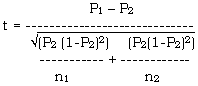
n1: first time sampled points
n2: second time sampled points
p1 : Percent of first sampled points,
p2 : percent of second sampled points.
The calculating result in this research, t < 1.96, there is no obviously difference of statistics. (table 2.)
3. Establishing interpretation symbols.
The reflecting features of Landsat image represent multiple information of landscape responded to its special characters, and based on comprehensive analysis for image features and relative professional knowledges, the interpreting symbols for each land form and grassland classification unit could be established and according to the interpretable levels of landsat imagery and considering the completeness and continuity characters of grassland classification system, the grassland resources distribution map was produced by employing visual interpretation techniques. (table 3.)
Grassland Class Distribution
Grassland vegetation is the result of vegetation community adapted to the new ecotopes, and affective and selected by changing of environmental conditions over a long period of time. Each grassland class can reflect the features of its located conditions. Taken grassland vegetations as a dominant factor, consulting other factors which is affecting the formation of grassland vegetation, the grassland resources in Zhonglan County can be classified into six classes.
I: Dry Steppe
Dry steppe is zonal vegetation in research area. It accounts for 36.87% of total land area. Fresh grass yield ranges from 1500 to 2850kg/ha. According to the difference of dominant species in community and mid-topographical condition, this grassland class can be further divided into 4 groups, there are Group of dry steppe in sandy and shallow valley areas: Group of dry steppe in low mountain and hilly regions; Group of dry steppe in wide valley and plain; Group of mountain shrubs-dry steppe.
II: Meadow Steppe
Distribution characteristics of this class is related closely with mountainous topography, and it appears mostly on foot of low mountains in the southern part of Zhenglan County. This class accounts for 0.83% of total land area and averaged 1950kg/ha of fresh biomass yield. This class has only one group, it is the Group of meadowfy steppe in foot f mountains.
III: Meadow
Meadow vegetation is a kind of semi-azonal vegetation type. This class accounts for 6.95% of total land area, and at present, it is in overgrazed situation. The fresh grass yield averaged only 1350kg/ha. Based on difference of topographical conditions, this class is further divided into 2 groups, Group of low – lying meadow in space of hills, Group of meadow in wide valley and terrace.
IV: Marsh Meadow
Marsh meadow is a kid of azonal vegetation type and its formation mainly caused by rising the underground water level or gathering water on low lying land. It distributes regularity on banks of rivers, ancient river courses and lake – around. The area of this class accounts for 3.64% of total land area and fresh grass yield ranges from 1250 to 9760kg/ha. According to environmental condition, the class can be divided into 2 groups; Group of meadow in flood region; Group of meadow in low-lying land.
V: Sandy Vegetation
Owing to strong effects of Hunshandake Desert, there are developing sandy vegetation widely in the north of the County. The area of this class accounts for 37.95% of total land area and fresh grass yield ranges from 1200 to 2900 kg/ha. This class can be divided into 2 groups; Group of dry steppe among sandy dunes; Group of Ulmus sp. and shrub in sandy steppe.
VI: Grassland in farming area
The southern part of this County, there has advantage environmental conditions for developing farmland and artificial pasture. Grassland in farming area accounts for the percent of 3.55 of total land area and it has only one group.
| Grassland Classes | Percent sampling points | % | Sampled Points | Points Actually with Situation |
| Meadow Steppe in Low Mountain area | 69 | 2.68 | 1 | 1 |
| Dry Steppe in Low Mountain area | 199 | 7.73 | 3 | 3 |
| Dry Steppe in wide Valley regions | 319 | 12.40 | 4 | 3 |
| Flatland Dry SteppeAmong Sand Duons | 231 | 8.98 | 3 | 3 |
| Sandy Vegetation | 1001 | 38.90 | 8 | 8 |
| Marshland | 269 | 10.46 | 4 | 4 |
| Grassland in Farming area | 96 | 3.75 | 1 | 1 |
| Others | 389 | 15.12 | ||
| Total | 2573 | 100.0 | 24 | 23 |
| Land Types | n1 | P1 | n2 | P2 | t |
| Dry Steppe | 3793 | 36.86 | 3692 | 36.45 | 0.7638 |
| Meadow Steppe | ---85.5 | ---0.83 | ---87 | ---0.86 | -------- 0.2351 |
| Meadow | 715 | 6.95 | 906 | 6.97 | -0.0582 |
| Marshmeadow | 548.5 | 5.33 | 548.5 | 5.41 | -0.2607 |
| Sandy Vegetation | 3904.5 | 37.95 | 3856 | 38.07 | -0.2243 |
| Grassland in farming area | 365.5 | 3.55 | 380.5 | 3.76 | -0.8144 |
| Woodland | 562 | 5.46 | 537.5 | 5.31 | 0.5009 |
| Lakes | 85 | 0.83 | 94.5 | 0.93 | |
| Others | 230.5 | 2.24 | 228 | 2.24 | |
| Total | 10289.5 | 100.0 | 10310.0 | 100.0 |
| Class | Image Features | |
| Color and tone | Shape | |
| Dry steppe | Darkbrown, lightbrown-red | Piece, flake, strip |
| Meadow | small green points are mixed up with darkbrown red color | Flake |
| Meadow steppe | Brown-red, pink-light pink | Flake, strip, piece |
| Marsh meadow | Brown-red, red | Flake, strip, piece |
| Sandy vegetation | On yellow and white color distributing red, brown-red points and spots | Flake |
| Grassland in farming area | Yellow color inlaid with dark blue spots with geometric forms | Various geometrical forms |
References
- The Vegetation of China (1983), Scientific Press
- The Vegetation of Inner Mongolia (1985), Scientific Press