| GISdevelopment.net ---> AARS ---> ACRS 1992 ---> Agriculture |
A study on single and
multiple polarization SAR image interpretation for agri-application
Zhang Wei, Yan
Tailai
Beijing Agricultural University
Remote Sensing Center
Beijing 100094, China
Beijing Agricultural University
Remote Sensing Center
Beijing 100094, China
Abstract
The imaging mechanics of SAR is very different from the other remote sensing system. It has got its own character. In this paper for the aim of agriculture Remote Sensing application, introduce the characters of the vegetations, soil, road interpretation and the measurement method of some articles in SAR image, and interpretation physics concept. As a comparison, introduce the interpretation characters, image processing and mapping of multi-polarization SAR image.
A. Background
Radar-system makes photos based on the reflection power of Radar emitted from its antenna, polarization direction and the phase-shift. This is one of the fundamental point of Radar Remote Sensing which is different from the other Remote Sensing system. We can select the depression angle, frequency, polarization direction, emitting power, modulation modle, and also select the receiving modle, i.e., polarization direction of reflection Radar wave, and threshold of reflection power. Therefore, man’s initiative of radar Remote Sensing is greater than other Remote Sensing systems on the respect of obtaining the information of ground. The distinguishing teach. features of radar include the following.
- All-weather and all-day-long time monitoring. Especially, this point is very important for the agricultural application, for example the crops yielding estimation, the disaster survey and the other monitoring work. This feature has been known for many people today.
- The resolution of radar Remote Sensing image is independent upon the solid-angle of object, but dependent upon the width of modulating pulse of radar. That is why the resolution of radar Remote Sensing image is independent upon the altitude of the sensor-carrier. At the very high altitude, the sensor of radar is able to identify the small object such as rail, steel tube, drainage ditch, even flying locust.
- Radar has the ability to penetrate ground. The wave penetrating the leaves of crops, so we can obtain the information of soil moisture under the leaves of crops. In L band, radar can penetrate the dry sand as deep as 20 meters.
- Using the effection of special reflection we can obtain the information of special objects, such as steel struction, water body, building etc.
- Based on the effection of two-specular-reflection or three-specular-reflection, radar is sensitive to the altitude change of object at small area, we can measure the height of sea wave, river bank, etc.
- Some special object such as some rocks, we soil, etc, they can affect the polarization direction of radar. If we can receive the cross-polarization radar image, we will identify the objects.
B. The Physical Fumdamental of Radar Remote Sensing
Fundamentally speaking, the responding of an object on the ground to the radar wave is determined by the dielectric constant (e) of the substance of the object and roughness of the objects. The dielectric constant is a complex number, and function of frequency of radar. The quantity of dielectric constant of water is varied between 20 to 80, but the ones of common substance is varied between 3 to 6. That is why radar Remote Sensing has the special capability to identify the substance with moisture. The respective substance of agriculture is just the one with moisture such as crops, trees, soil and so on. On the ideal case, i.e., the smooth and homogenous surface of soil, the reflection ratio of radar power is expressed by :
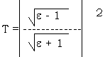
where r is the reflection ratio of radar power, it increases with the increase of quantity of dielectric constant of substance. To the dry soil, the reflection ratio r is as small as 0.04, but to the saturated soil with water, r reach 0.52. However, very few agriculture field can be dealed with the object with smooth surface. To judge the smooth surface we use the following equation:
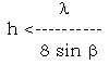
where, b is the depression angle, l is the wave length. This inequality tell us that within the range of x/sin b, the undulating amplitude on the surface of ground being smaller than h, the surface can be considered as the smooth surface is called the rough surface, which results in the defuse reflection (scatter instead of specular reflection. In order to describe the scatter phenomenon, the back-scatter coefficient should be defined. It is defined by the following equation.
Pe = s0, Hs
where, Pe is the received go-back wave power from the scattering body; Hs is the transferring function the independent variable of which includes radar emitting power, wave length, depression angle, slant range and so on; s0 is the back scatter coefficient. The coefficient is dependent upon the physical characteristic of object.
According to the working results of Univ. of Kansas, on the certain case do soil (roughness and structure of soil), the back-scatter coefficient of radar is linear relation with the soil moisture within the surface layer, (2 – 5cm), i.e.:
s0(dB) = A + B Mv
where, A is mainly dependent upon the roughness of soil, B is dependent upon structure of soil. The report of Univ. of Kansas indicates that the value of A is larger on the case of HH of VV polarization. That means on the case of polarization, the back scatter coefficient is more dependent upon the soil moisture.
C. The verification on the single polarization SAR image
On the area covered by the SAR image that we used, there are some typical fields : wheat field, vegetable field, rice-wheat field, and resident field, these fields have the different reactions for the radar signals. The absorption, penetration and scatter. These differences were recorded on the film as a different grey scales.
| 1 | 2 | 3 | 4 | 5 | |
| HH VV VH |
d g d |
g g d.g |
b b b |
d d d |
g d g |
1. good wheat field,
2. rice wheat field,
3. resident field,
4. vegetable.
5. whet-vegetable
d : dark
g : grey
b : bright
The mechanics of the agri. field reaction for the radar signal is very complex. Even you have got the real time ground data, it is very difficult to interpret the full scene of the SAR image exactly. And now we would like to dry to analyse the different growth status of the wheat appear on the image according to the ground data that we have got.
1. The good growth status, the wheat is higher, leaves are wider, and the water of the leaves is not too much.
2. The worse growth wheat, the soil background is rice-field, the moisture of the soil too high that the wheat is lower and leaves are narrow.
The good wheat field is dark on HH polar image, perhaps because the density of the wheat is higher, and the top surface of the wheat is smoother. So the scatter is weake. But the worse wheat has got the contradictory situation. On the VV polar, image, this difference is not clear. On the another experimental area, we found that the plough plot uncovered by plant is darker that the field covered by plant. We have known that the quantity of dielectric constant of drier soil is smaller than one of the wetter soil, which results in the back- scatter, coefficient of drier soil being smaller than one of the wetter soil. Usually, the plough plot has the well-laid-out boundary, so the imagery is clearly distinguished from the grass land. In fact, road is a plot of bare field. The surface is smooth enough, so that the specular reflection makes it become a dark line on the image of radar. Due to the effiction of two-specular-reflection, a small ditch on the field can be identified from the image although the width of ditch is much smaller than the resolution of image of radar, when ditch runs parallel to the flight path of the radar sensor.
Although the B/W SAR imager has got richful information, but the grey scale recognition power of the human people is limited; furthermore, on the single polar. Imager, different information recorded on different images, it is not easy to make the interpretation and to use. To resolve this problem, we have done some work on the multi-polar. SAR image synthetic processing, so the information can be comprehended and the useful information can be extracted.
D. Multi-polarization Radar image synthetical processing and analysis
The back scatter of the different growth status wheat is different, the different fields (wheat, corn, rice, vegetable, and the cultivated fields) have got the different reactions for radar signal. And the patterns of the difference that corresponding to the different – polar, radar signals is very different. (see figure ). The right vertical axis of the figure is the different transparent ratio of the film on which the different information was recorded.
When we composite film with putting different filters on the different polar, radar film, according to the color-plus-concept, different fields and different status of the same object, were appeared with the different color, and very easy to be recognized, for instance, in Figure , (1) is wheat, the transparent of (1) on HH film is 41%, on VV is 50%, on VH is 33%. Out the Blue, Red, and Green on the HH, VV and VH, and composite them, we have:
41B + 50R + 33G
= 33 Grey + 8 M + 9 R
So we know that wheat on the image is dark red. Similarly, we can get the color of rise is Magenta (with Blue-Grey). Certainly, we can do many other arythms, and make the information extraction better.
E. Some suggestions
Because of the advantage of the micro-wave Remote Sensing and radar system we have got the bright future in this field. But until now, there is no sat-system carried the multi-band or multi-polar, radar system. We hope, not long from now, that the satisfied these kinds of sat-system will contribute more data to all of us.
(June, 1992)
References
- Manual of Remote Sensing, Second Edition, American Society of Photogrammetry, 1983.
- Soil Water Modeling and Remote Sensing, by Thomas J. Jackson IEEE, No. 1, Jan. 1986.
- Soil Moisture Measurement Using Probable Dielectric Probes and Time Domain Reflectometry, by B. Brisco and T.J. PILTZ, Water Resources Research, Vol. 28, No. 5, May 1992.
- Radar Image : Geology Interpretation and Application, Guo Huadong, Scientific Press, 1991, China
- Radar Image and Its Application, Shu Shiwei, Rali Press, 1988, China.
- Quantitative Soil Moisture Extraction from Airbone SAR Data, by
T.J> Pultz and R Leconte, Canada Journal of Remote Sensing, Vol. 16,
No. 3, OCT. 1990