| GISdevelopment.net ---> AARS ---> ACRS 1991 ---> Water Resources |
Results of the drought
investigations in Mongolia and a proposal for future development
Namkhai. A, Badarch.
M
Drought as recurring phenomenon, especially in the semi-arid regions of the Earth, ranks as one of the foremost among the Earth’s, tragedies, representing the severe and sometimes Catastrophic consequences of activities. One of the important research projects of Mongolian People’s Republic (MPR) is drought. In Mongolia made several research projects on the study of drought, the results of which already published (Mijiddorj.R, Namhai.A, Mend. S., 1985). B. Zhambaazhamts (1985) developed present the data on drought frequency. The drought frequency is calculated with the help of dryness index expressed through the ratio of humidity deficit sums to precipitation amount sum for decade. He noted, that the drought criterion changes depending on Nature-Climatic Zones. Namhai.A., Jadambaa, SH[1980] studied the meteorological aspects of the drought and developed the method of predicting doughtiness and overwetting of MPR.
For studying drought in Mongolia there were used several criteria those indicating drought and the best of them were Si criterion (Ped.D.A., 1975), in which used combination of temperature and relative humidity at 13 O’clock of the day which reflects drought event within a month.

Here, DT, DR are anomalies of temperature and monthly of seasonal precipitation respectively ; sT, sR standard deviation for and respectively. The drought criteria (Si) changes depending on month. Proceeding form this situation the following criteria are accepted.
- Si=1 – 2 – Weak drought
- Si = 2 – 3 – moderate drought
- Si>3 severe drought
- Negative value of Si indicates overwetting

Figure1 The droughtness and overwetting of different part(western, central, eastern,southern) of territory of Mongolia
A conspicuous features of figure 1 is that the years appear to be more severe 1941-1948 than years 1975-1982 (specially for western, southern parts). The maximum value of the overwetting period were observed in 1956 (western and southern parts), 1960 (Eastern), 1961 (Central) 1985 (western, eastern, central parts). Recently, the years 1982-1987 in almost territory of Mongolia have observed the overwetting, however, only southern part observed the weak drought.
These criteria were used for determining the drought frequencies for 1940 – 1985 separately for spring and summer. Figure 2 shows the empirical probability of the severe drought (Si>12) on territory MPR for spring (2a), and summer (2b), which were calculated for all meteostation which located in different nature and climatic condition. Let’s note that the empirical values of probabilities of the severe drought are relatively small. They are computed with limited data set and have only approximately nature.
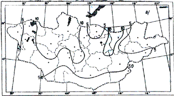
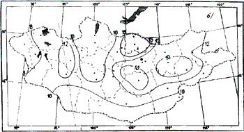
Figure 2 The empirical probability of the severe drought(Si>2) on territory MPR for spring(2a), and summer(2b)
For comparing the values of the drought rainfall we have considered the annual rainfall departures (1940 – 1988) for territory of MPR. The considerable variability in rainfall of this country is reflected on figure 3. The graphs show that during the period preceding 1952, the amount of rainfall was though it, grows up below than “Normal” and the drought period has coincidenced.
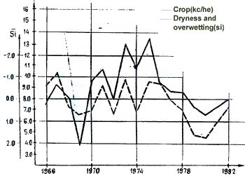
Figure 3 Rainfall departure for territopy of MPR
Beginning 1953, a period of above “normal” rainfall came, and this might have played a significant role for beginning overwetting period. Twelve years later (C. 1975) beneficial period ended and the drought returned, with various culminating in beginning of overwetting since 1985 is particularly remarkable.
Attempts were made to indicate the relationship between the crops and drouhtness index (Si) for years 1966-1982 on the central part of the territory of MPR. Figure 4 shows this relationship. The correlation coefficient is 0,81 a value that should be made more precise during future investigations with newly derived data. Monitoring of drought is required for taking corrective measures, at appropriate times through the cropping season. Monitoring also provides information on the persistence/periodicity an assessment of severity of drought in area.

Figure 4 The relationship between the crops and droughtness
The drought distribution maps compiled on the basis of ground meteostations data do not fully satisfy requirements, for the following reasons. First, agrometeorological information is received only once every 10 days. Second drought maps are compiled on the basis of data measured by stations situated in populated areas, where the meteorological parameters which influenced to drought differ from those in the adjoining pasturable regions.
Therefore, for a territory as a large as Mongolia, with its sparse population, it is more convenient to apply satellite data.. Satellite data enable daily monitoring of vegetation, precipitation and ground temperature, differences over the whole territory of the country. With the above objectives mind a project for development of a drought assessment and monitoring system is just beganing in Mongolia with participation by the Hydrometeorolgoical research Institute, Land use management institute, water problem institute and National Remote Sensing centre sponsored by the monitoring and scientific department of the State committee for nature and environment control of MPR.
Drought assessment and monitoring system aims to jointly use satellite and ground data whole country on a weekly basis through the spring and summer, when occurred drought events in Mongolia. For this study, we have choose the NOAA AVHRR data instead of Landsat MSS data, because NOAA satellites cover the same area every six hours, which is very advantageous for monitoring changes of the drought and helps provide, enough multitime images in a short time. For drought assessment and monitoring system of Mongolia we will use methodology which was developed by Agency of the Remote Sensing of the India. (S. Thirvendgadachari, 1988).
For this system will use satellite and ground data (both historical and operational). The ground historical data must be contain with data of the rainfall, crop calendar, crop condition, aridity anomaly, land utilization, pest/disease attack, drought history. The crop condition report, rainfall, aridity anomaly which to be get from the decade weather report will belong to the both historical (seasonal normal vegetation index profiles) and operational (vegetation index statistics and vegetation index maps) data. All above mentioned satellite and ground data will be fed to geographic information systems (GIS).
This system will developed on micro-computer for the analysis and management of remotely sensed data and other spatial data. So it will called the Remote Sensing data (AVHRR) and geographic information system (GID) for drought assessment and monitoring in Mongolia. It should be a practical, economical and flexible system and can be used conveniently for various studies.
If the image processing computer can communicate data to a microcomputer, the processed image data can be fed into the GIS directly from the image processing computer. The graphic data, and attribute data will fed into the GIS separately by using a digitizer. They formed files in the system and will stored on a database. The graphic data will stored in vector file format then a raster file (a grid representing a 1 km x 1 km area) will produce from the vector file by a high accuracy interpolation method, the point-by-point weighting linear interpolation method. All analysis will then do on the raster file. The development of drought assessment and monitoring system in Mongolia will be extremely useful prediction and ability to manage natural disasters such as drought and desertification in Asian Continent.
Conclusions
Drought, as an inevitable part of climate, is a recurrent phenomenon in the arid and semi-arid parts of the country. Persistent and frequent droughts may possess the capability to cause irreversible damage to a fragile ecological system even if previous rainfall nomals are restored. Design and efficient use of a multi-stage Remote Sensing and ground system will significantly affect the success rate of the application of Remote Sensing in study of drought and desertification which become global of the world.
References
- Namhai.A., Jadambaa. Sh., The studies of the drought investigation, the scientific papers of hydrometeorological institute N5, Ulaanbaatar, 1980.
- Mijiddorj, R, Namhai.A, Mend. S Atlas of the droughtness of MPR, Ulaandbaatar 1985, P 339.
- Ped. D.A, on the index of droughts and excessive rainfall. Trudy of hydrometeorological centre of the USSR, 1975 N 156, p. 19-38
- Jambaazhamct. B, Bat. D The Atlas of the climate and groundwater resources in the MPR. GUGMs of Mongolia 1985 73P.
- Thiruvengadachari. S., “Space and drought Management, current event session IY 39th JAF congress, Bangalore, India (October 8-15, 1988)