| GISdevelopment.net ---> AARS ---> ACRS 1992 ---> Water Resources |
Development of Water
Resources Information System
S. Bhos
O.R. Unit., CSIR Complex, NPL Campus, PUSA, New Delhi-12, India
K. Sen
NRDMS data base, Vikas Bhayan, Sultanpur, UP, India
O.R. Unit., CSIR Complex, NPL Campus, PUSA, New Delhi-12, India
K. Sen
NRDMS data base, Vikas Bhayan, Sultanpur, UP, India
Abstract
Problems related to Water Resources development and management are complex. 'Systems-approach' to solution of such problems has been tried in this paper. Issues related to demand and supply of water for specific sectors like irrigation, drinking purposes etc. have been dealt as distinct sub-systems. Data bases with specific processing and I-O functions have been considered for different sub-systems. Finally, the sub-systems have been integrated to develop a Water Resources Information System (WRIS) for a given region in totality. A case study has been undertaken to demonstrate the workability of the computerized WRIS.
Introduction
Systems approach to a problems solution essentially means unit has a definite I/O relationship and interface with its neighbours. Development of a WRIS needs consideration w.r.t. the data requirement, data updation, nature of processing, reporting style/frequency, levels of decision making, logistics and parameters for strategic decisions. Some of these aspects need mathematical models for precise estimates.
Demand of water in a region has been considered under Irrigation Water Requirement and Drinking purposes while supply is considered under ground water, rainfall, canal and tanks & ponds (fig. 1 & 2).
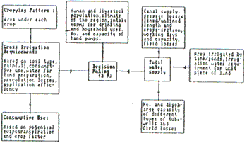
Figure 1
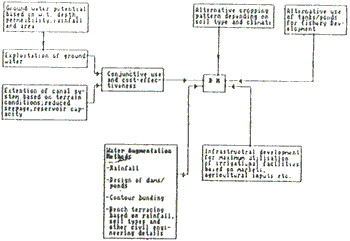
Figure 2
The former depends on the dynamics of cropping pattern and irrigation application efficiency while the latter is governed by the water conveyance efficiency of the distribution systems and exploitation of ground water. The following sections illustrate the comprehensive models and data bases for different sub-systems.
1. Demand of Water
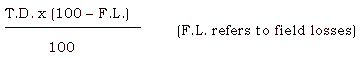
This sub-system consists of two units, one for irrigation and the other for drinking and household needs. The data input for the former are cropping pattern, crop-coefficients, evapotranspiration, rainfall and application efficiency. The model used is given as;

Where, Cu, Eo, Kc, ER, AE and A refer to consumptive use, evapotranspiration, crop-coefficient, effective rainfall, application efficiency and area under a crop respectively. The outputs are monthwise volume of irrigation water requirements for different crops. The summation for a month gives the total water requirement at field level for the existing cropping pattern. The second unit calculates the household and drinking water requirement using the different norms (like ICMR, WHO, etc.) for the specific region (arid, semi arid, humid etc.) and the projected human and livestock population for a given time frame.
2. Supply of Water
This sub-system comprises of three units. The first one is for tubewell, the second is for canal while the third is for pond - supply. Data inputs to the first unit are, number & discharge capacity of different types of tubewells and field losses. The model used is:

where, T.D., N and D refer to the total annual discharge, number of tubewells and discharge capacity respectively. The actual supply is obtained from;
The second unit requires the discharge at the canal head, distances traveled (lined/unlined) before reaching the field, cross-section of separate portions, seepage coefficients, no. of working days, capacity of the minors and field losses. The outputs are monthwise release of canal water at field level.
The third unit takes area irrigated by tanks and ponds and average water required for irrigation of unit piece of land as inputs and gives monthly supply of irrigation water (for a season) as output.
3. Strategic decision making
This sub-system uses monthwise demand and supply of water for a region as inputs, compares them and simulates the alternatives either to enhance the supply or cut-short the demand. The groundwater potential, cropping intensity, irrigation intensity, canal reserves, agroclimatic/soil constraints and food habit form an integral part of the data-base in this sub-system.
4. Ground water potential
This subsystem needs monthwise depth of water table, tubewell discharge, irrigation return flows, seepage from canal sides, average annual rainfall, geographical area, infiltration co-efficient and permeability of aquifer as inputs. It calculates recharge to the aquifer, underground inflow/outflow and the recoverable potential of groundwater.
5. A Case Study
In this section a case study on WRIS has been undertaken for a block in Uttar Pradesh, India. Over 95% area of the block is under tubewell irrigation. The relevant data have been put in different subsystems whose outputs are narrated in separate sections. Finally, strategic decisions have been arrived at.
- Irrigation Requirement: Irrigation water requirement vary
with time and crops. They are functions of consumptive use of water by
crops, effective rainfall and water requirements for special purpose
like land preparations, leaching of salts etc. In this section
irrigation water requirement at the field level for the actual areas
irrigated by tubewells during year 89 are estimated. In addition the
water requirement for actual cropping pattern in the block during the
same year is also evaluated. The major kharif crops are rice and
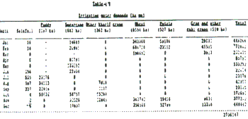
sugarcane. While wheat is the major rabi crop. Table-1 & 2 depict
the results.
- Ground Water Draft:
The extraction of ground water in the block is through tubewells, dugwells, dug-cum-bore wells and pump sets. The total annual draft of ground water depends on the number and yield of wells in operation each year and the capacities of the pumps to lift water. In 1984, the Ground Water Estimation Committee of the Ministry of Irrigation, Govt. of India provided the norms for irrigation potential of different types of wells. However, the specific norms for the wells in the block have been given more precisely by the State Ground Water Board, Lucknow, UP as follows:
State Tubewells : 10.85 ha.m/y Private Tubewells : 3.32 ha.m/y Pumping Set : 3.00 ha.m/y Dug Well : 0.60 ha.m/y Dug-cum-bore well : 0.90 ha.m/y
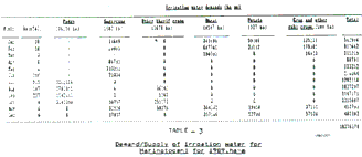
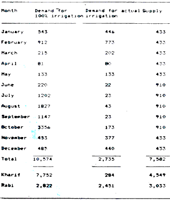
Table - 3 Demand/Supply of irrigation water for Haringtoganj for 1989, ha-a
Month Demand for 100% irrigation Demand for actual irrigation Supply `January 543 446 433 February 912 773 433 March 215 202 433 April 81 80 433 May 133 133 433 June 220 22 910 July 1202 23 910 August 1827 43 910 September 1147 23 910 October 3356 173 910 November 453 377 433 December 485 440 433 Total 10.574 2,735 7,582 Kharif 7,752 284 4,549 Rabi 2,822 2,451 3,033
Using these norms and the information on the number of different types of wells functioning each year, the ground water draft for the years 1975 to 1989 has been estimated. The total annual draft increased from 83.8 MCM in 1975 to 108.3 MCM in 1989.
- Ground Water Recharge
Rainfall and irrigation return flows constitute the principal sources of ground water recharge. The Ground water Estimation Committee recommended specific norms for the estimation of recharge from each of the above sources for the conditions prevailing in different parts of the country. These norms for the block Harringtonganaj are:
1. Recharge from rainfall = 18% of normal rainfall
2. Return flow from irrigation fields = 30% of ground water delivered at outlet
The return seepage figures include losses in the field channels. In the following sections the recharge from different sources is estimated based on the available data for the period 1988-90.
Recharge from rainfall for the period '88-' 90:
Area of the Block = 23123 x 10 sqm
Av. rainfall for the = 1.11m
Period '88-' 90
Annual recharge from rainfall = 45.76 MCM
Return seepage from ground water irrigation:
The average annual draft of ground water for the period '88-' 90 was about 108 million cu.m. The recharge from this to the ground water body is 30% or 32.4 MCM.
Thus the total average annual recharge from rainfall and ground water irrigation is estimated as 78 MCM.
- Ground Water Balance :
The group water balance in the aquifer is given as:
Change in ground water storage = (Total recharge) - (Total draft) + (Ground Water inflow/outflow from the basin).
The net rise in the ground water table during 1988-90 was 0.6m which corresponds to a net rise of 18 MCM in the ground water storage. The total recharge and draft during the period are 235 MCM and 325 MCM respectively. Thus, from the above equation the annual ground water inflow may be estimated as 36 million cu.m.
- Ground Water Potential:
Ground Water Resources can be divided into dynamic and static components. The maximum observed thickness of the zone of fluctuation is determined using the hydrographs of observation wells. This is done by taking the difference between the lowest pre-monson and the highest post-monsoon water level during the period of record. In Harringtonganj, Faizabad, a record covering the period 1975-90 is available at a single observation well. The lowest and the highest values have been recorded as 7.32m and 12.80m respectively. The depth of the zone of fluctuation for the alluvial plains of the block is assumed to be uniform at 13%. The gross recharge for the period 1975-90 is;
Gross Recharge = (Thickness of water table fluctuation zone) x (Specific yield) x (Area of the block)
= 5.48 x 0.13 x 23123 = 164.73 million cu.m
This estimate of mean gross recharge includes the effect of the recharge and discharge components during the monsoon, but not the ground water inflow during the non-monsoon period.
Assuming 50% of total inflow (36 MCM) during the non-monsoon season the total annual recharge amounts to 183 MCM. As per the GWEC norm the recoverable recharge is 70% of the gross recharge. This, the net ground water available for recovery in the block is 128 million cu.m against the actual exploitation of 108 MCM in 1989. Thus, there is further scope for ground water development in the block by 20 MCM per year with the assumption that the aquifer is of uniform thickness and spreads uniformly below the entire block.
- Results:
In 1989 for a gross cropped area of 25176 ha which corresponds to cropping intensity of 154% for the block, the total water requirements at the field level were 105.7 MCM. The total supply at the field level was 75.8 MCM (Table-3). This for 30% losses in water courses. The net shortage at the field level is thus 30 MCM. If the entire available ground water potential of 128 MCM is developed, i.e. the draft is increased by 20 MCM, 90 MCM of water will be available at the field level. The net deficit would still be about 16 MCM for 1989 cropping pattern (for 43% area under paddy).
Conclusion
The study highlights an approach for system development for decision making and information management for Water Resources Utilisation. The system can simulate alternate cropping pattern and conjunctive use of surface and ground water of for optimum utilization of available resources. There is further scope for incorporating other relevant sybsystems like prediction models for rainfall, cropping pattern, total population and live stock for scenario building. Maintenance of
Irrigation facilities like tubewells, canals and tanks, cost/benefit analysis of different sources of irrigation will also be considered in future.
Acknowledgement
The authors are grateful to the Department of Science and Technology (specially to Dr. R.K. Midha, Director, NRDMS for sponsoring and providing encouragement to the studies. They also thank Prof. A. Ghosal, Secretary, Society of Management Science and Applied Cybernetics for his keen interest in the study.
Reference
- Ghosal, A. (1986) Pragmatic Cybernetic (ed)
- Sharma, P.B.S. and Rao, N.H. (1986) Resource Analysis for Integrated Development, Dev Press, New Delhi.
- Ray, S.B. and Sharma, S.N., (1983) Guidelines for Water Management. National Seminar on Integrated Water Management in Canal Command Areas. Water Technology Centre IARI, New Delhi.
- Ghosh, S. (1989) Management of Water Resources in a command area. Proceedings of 11th ACRS, Kualalumpur.