| GISdevelopment.net ---> AARS ---> ACRS 1992 ---> Water Resources |
Application of Landsat based
reflectance Zoning in estimating groundwater depth and salinity : A case
study fro the gangetic alluvial terrain of western Uttar Pradesh,
India
V. N. Bajpai
Department of Geology University of Delhi,
Delhi-110007, India
K. V. G. K. Gokhale
Department of Civil Engineering Indian Institute of Technology
Kanpur-208016, India
Department of Geology University of Delhi,
Delhi-110007, India
K. V. G. K. Gokhale
Department of Civil Engineering Indian Institute of Technology
Kanpur-208016, India
Abstract Visual reflectance zones corresponding to deferent intensity of gray levels have been demarcated for the Gangetic Alluvial Terrain in Western Uttar Pradesh on band 5 of the Landsat imageries. Four reflectance zones as 'a', 'b', 'c' and 'd' of percent reflectance values 7.14-14.28, 14.28-21.42, 21.42-28.56 and > 28.56 respectively, represent groundwater area of different depth to groundwater and salinity. In general, the reflectance zones 'a' , 'b', 'c' and 'd' are correlated with groundwater depth ranges of 4-6m, 6-12m and > 15m. However, there are certain deviations in depth ranges in c and d zones due to salinity of soil and groundwater as also due to ravenous tract. While the boundaries of ravenous tract lying within the zone 'd' have been separated out on imageries on the basis of gully pattern standing in definite contrast with the surrounding, the areas of salt efflorescence and high groundwater salinity are identified on band 7 imageries, where they appear relatively darker. It has been found that such a correlation of reflectance zones with depth to groundwater and salinity can be made effectively applicable only when supported by field information of soil and groundwater situation for selected locations.
Introduction
Morphological characteristics, soil condition and vegetation together reflect the groundwater situation in a terrain and therefore their use can be made in estimation of depth to groundwater and salinity. The vegetation is rather more important parameter as its general vigour alone reflects the groundwater situation in terms of its depth and quality. Moreover, as the total plant assemblage in any area is more reliable groundwater indicator than the individual plants (Nefedov and Popova, 1969), satellite imageries can be chose for studying the relation of vegetational strength with the depth to groundwater as also with the salinity of soil or groundwater. Such a study on the basis of vegetation have its validity, as the scattered vegetation on the ground will appear closer on imageries due to smaller scale. Further, the assessment of water table depth would be ideal in a terrain of similar morphology and where the soil and water quality are favourable to support vegetation. However, even the regionally flat terrain will have several heterogeneities in terms of topography and quality of groundwater or surface soil, thus making difficult the assessment, and therefore due corrections should be made before finalizing the work, the western part of the Gangetic Alluvial Terrain having wide spectrum of above variations has been therefore chosen for such a study. The terrain is well known for its areas of groundwater salinity (Singh, 1976; Baweja et al., 1980) as also the water logging in the vicinity of canals where salt incrustation develops towards dry season.
Principle and Method of study
The depth estimation in general involves the principle that the regions with different grey tones on imagery represent vegetation of varying types and different densities that are closely related to groundwater depths.
Favourable growth conditions prevail in the region where the water table is situated below the area of influence of evapotranspiration (about 10m or deeper). These regions appear predominantly lighter in band 7 (near infrared regions) imagery and darker in band 5 (red region) imagery, indicating a dense coverage of vegetation with high chlorophyll content (Kruck, 1976), wile vegetational mapping can be carried out on band 5, the precise situation as whether the scanty vegetation in an area is due to deep groundwater or salinity can be ascertained on band 7 where the areas of salinity appear relatively darker (Kruck, 1976). Thus, the combined use of band 5 and band 7 can provide an assessment of water quality.
In the present work, reflectance zoning has been achieved on band 5 imageries (acquired by Landsat 2 on 30.1.1977 and 8.3.1977) using a 15-step gray scale printed adjoining the image for radiometric calibration reference. The transmittance of the gray level steps on MSS imagery varies linearly with entrance-pupil radiance level and therefore each step would correspond to 1/14 of the maximum radiation (Slater, 1980). As the gray scale shows 14 tonal blocks in decreasing intensity of gray tone, each block formed between two gray steps would indicate the reflectance difference of 7.14 percent. The darkest block having the reflectance upto 7.14 percent indicates the tone visually similar to the tone of surface water bodies or areas with dense vegetation and water together and therefore has not been used for depth study. Latter blocks indicating the tone as associated with soil and vegetation on the terrain have been utilized in the study of depth-reflectance relationships. In the present work, four zones with percent reflectance ranges of 7.14.-14.28, 14.28-21.42, 21.42-28.56 and > 28.56 have been delineated corresponding to decreasing order of vegetational strength. These zones designated as 'a', 'b', 'c' and 'd' have been known for groundwater depths within them on the basis of data obtained from State Groundwater Organisations pertaining to the imagery dates. The depth information collected for a location situated within a reflectance zone has been extrapolated over the entire zone to present similar depth, the process termed as correlation in the present work. Further, in order to confirm the validity of this correlation, several locations within these zones have been checked for actual groundwater depths. In general, a good correlation between the zones and depths has been observed. However, certain areas did not fit in this correlation and their anomalous character has been explained in terms of groundwater salinity and soil salinity associated with patches of salt incrustations in the vicinity of canals. For this work, data of chloride content in groundwater for selected locations from available reports (Agarwal et al., 1979; Garg and Sahni, 1979) have been utilized.
Application of Reflectance Zoning in the Terrain
The map indicating the reflectance zones has been presented in Fig. 1. As evident from the reflectance map that in western part of the terrain, in Agra and Mathura districts, in general the 'c' and 'd' zones dominate in the cis- Yamuna (west of the river Yamuna) tract while a substantial area in the trans- Yamuna (east of the river Yamuna) track belongs to the 'a' zone. It can be mentioned here that the'd' zone also includes ravenous track where the soil and the vegetation are very less developed. This track located on either side of the rivers and their tributaries stands out in definite contrast with the surrounding flat uplands on imageries (Bajpai and Gokhale, 1986) and has been separated out from the theme of present work.
It has been found in the field investigations that the soil in cis- Yamuna tract has salt content to such an extent that it cannot support much vegetation. The problem has been accentuated further since the inception of Canal system and consequently the once well known cotton-growing fields of Kosi, situated in northern part of the tract, have been converted to barren lands. High water table in the vicinity of the canals resulted in impeded drainage, preventing the natural leaching of salts which, otherwise, also has been limited due to thick clay horizons in the subsurface.
For different locations distributed over the terrain in the Agra and
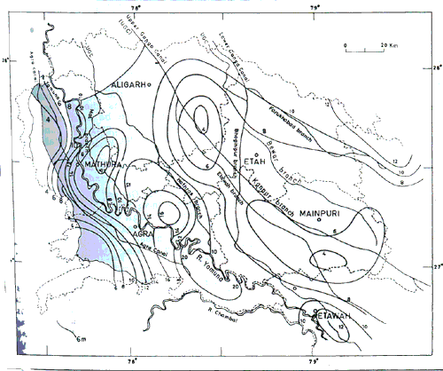
Fig. 1. Reflectance zonal map o the gangetic alluvial terrain of western Uttar Pradesh prepared form band 5 imageries
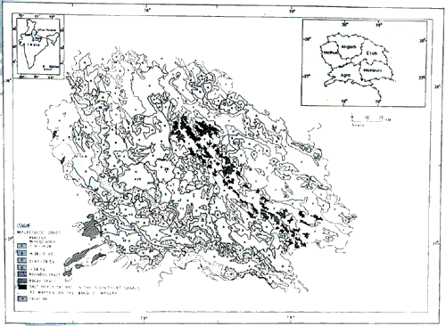
Fig. 2. Map Indicating Groundwater Depth contours and the Network in nangetic alluvial terrain of western Uttar Prades, India
Mathura districts, the reflectance zones are indicated in Table. Details regarding the water quality expressed in terms of chloride content and depth to groundwater for all the locations are also presented in the table to facilitate their correlation with various zones. It can be observed that in areas with flat land, sandy soil and fresh groundwater, the 'a' zone represents groundwater depth from 4 to 6m. Within 4m of depth, the areas are prone to water logging and are therefore not presentable by 'a' zone. Areas with depth ranging from 8 to 12m have been noticed within the 'b' zone. The 'c' zone incorporates areas with groundwater situated between 12m and 15m of depth. The zone 'd' has been observed to represent areas with groundwater situated beyond 15m of depth. This pattern of zonal reflectance in terms of groundwater depth is evidenced to be valid for area where groundwater salinity is low (chloride 200 ppm) to influence either the vegetation or the soil. However, the depth boundaries for the zones are observed to be considerably disturbed in the case of area with high groundwater salinity. For example, around Fatehpur Sikri, Khairagarh, Kiraoli and Malpura (location nos. 19, 20, 23 and 27, Table) the reflectance zone has been identified to be of 'd' type while the actual field values for the groundwater depth have been observed between 3m and 7m, which would have belonged to the 'a' zones in absence of salinity. The high water table by carrying the salts to the surface has contributed to the high salinity. The other areas around Tantpur and Jagnair (locations 16 and 17), where the groundwater depth is around 5m correspond to 'c' zone of reflectance because of high groundwater salinity. Similarly, areas like Kachaura and Achhnera (locations 10 and 11) have been observed to be having reflectance of category 'b' due to moderately high ground water salinity. At Kagraul and Saijan (locations 13 and 14), the groundwater has been found to be situated at around 8m of depth, while the reflectance values denoted zone 'c' due to salinity. Similar disparity has been noticed around Kitham (location 22).
In Mathura district, the cis-Yamuna tract has problems of high water table together with salinity and consequently, the areas around Goverdhan, Saunkh, Barsana, Sehi, Kosi and Nandgaon (location nos. 34, 35, 36, 38 40 and 42 in the table) are represented by 'd' tone. In trans-Yamuna tract also, there are deviations in reflectance zones due to salinity. For example, the area around Akbarpur (location 41 in table) falls within 'd' zone inspite of the depth being 2.5m. Deviations in other depth zones are also observed around Ol, Raya, Gokul and Naujheel (location nos. 30, 31, 33 and 39 in the Table). Thus the depth estimation in areas of high salinity arrived at on the basis of reflectance zonal mapping on band 5 would be at variance with the actual groundwater depths, since the reflectance observed on the imageries is the combined effect of groundwater situation and its quality. Such areas can be confirmed from an examination of band 5 and band 7 together. Otherwise, only on band 5 the areas with vegetation corresponding to 'a' and 'b' zone can unmistakably be predicted for groundwater depths.
Reflectance study Along Canals
The regions in the vicinity of the Lower Ganga, Upper Ganga and Agra Canal systems have been examined on Landsat imageries. At several places, the water table is very close to the surface and the high evaporation rates have resulted in increased salinity in the surface soil and also in groundwater. For the purpose of identification and mapping of such areas of salinity, a base map (Fig. 2) indicating the canal network and groundwater depth contours (February-March, 1977) was prepared for the terrain.
A close study of reflectance zonal map (Fig. 1) and the base map (Fig. 2) has revealed the interesting tonal changes in areas along the canal network. In general, the pattern of distribution of the 'c' and 'd' zones appears to bear a relation with the distribution pattern of canals. Several occurrences of 'c' and 'd' zones are noticed in the vicinity of (i) Lower Ganga Canal: in areas ground Etah, within the area located between the Bewar branch and the Bhoginipur branch adjacent to the bifurcation, (ii) Upper Ganga Canal: in the south-eastern part of Aligarh and Mainpuri districts, in area near the crossing of Kanpur branch of Upper Ganga Canal and the Bhoginipur branch of Lower Ganga Canal, and in area between Aligarh and Etah along Etawah branch; and (iii)
| Location No. | Place | Chloride (ppm) | Depth to groundwater (m) | Reflectance zone |
| Agra District | ||||
| 1. | Tundla | 163 | 5.3 | A |
| 2. | Mitauti | 14 | 5.1 | a |
| 3. | Barhan | 71 | 5.5 | a |
| 4. | Bichpuri | 36 | 4.3 | a |
| 5. | Naglabich | 182 | 4.9 | a |
| 6. | Kotla | 158 | 5.4 | a |
| 7. | Khanda | 166 | 5.3 | a |
| 8. | Bateshwar | 49 | 8.0 | b |
| 9. | Iradatnagar | 163 | 11.5 | b |
| 10. | Kachaura | 575 | 5.4 | b |
| 11. | Achhnera | 677 | 5.3 | b |
| 12. | Etmadpur | 166 | 14.8 | c |
| 13. | Kagraul | 1091 | 8.0 | c |
| 14. | Saiyan | 426 | 7.5 | c |
| 15. | Fatehabad | 108 | 14.9 | c |
| 16. | Tantpur | 1420 | 5.3 | c |
| 17. | Jagnair | 1949 | 5.6 | c |
| 18. | Sikandra | 145 | 18.0 | d |
| 19. | Fatehpur Sikri | 1171 | 7.6 | d |
| 20. | Khairagarh | 1005 | 3.0 | d |
| 21. | Agra | 693 | 14.5 | d |
| 22. | Kitham | 1020 | 10.0 | d |
| 23. | Kiraoli | 1184 | 2.8 | d |
| 24. | Kukapur | 36 | 21.2 | d |
| 25. | Nandagaon | 21 | 33.5 | d |
| 26. | Firozabad | 75 | 15.7 | d |
| 27. | Malpura | 1724 | 2.8 | d |
| Mathura District | ||||
| 28. | Sahpau | 5.55 | 34 | A |
| 29. | Bisawar | 5.4 | 89 | a |
| 30. | Ol | 5.3 | 354 | b |
| 31. | Raya | 4.3 | 475 | C |
| 32. | Chatta | 7.1 | 852 | c |
| 33. | Gokul | 8.5 | 418 | c |
| 34. | Goverdhan | 3.4 | 1070 | d |
| 35. | Saunkh | 2.5 | 3205 | d |
| 36. | Barsana | 3.2 | 1200 | d |
| 37. | Mathura | 10.0 | 2308 | d |
| 38. | Sehi | 3.3 | 950 | d |
| 39. | Naujheel | 12.0 | 1067 | d |
| 40. | Kosi | 3.4 | 568 | d |
| 41. | Akbarpur | 2.5 | 1704 | d |
| 42. | Nandgaon | 2.9 | 583 | d |
Agra Canal network: in the northern and south-western parts of the cis-Yamuna tract and to a limited extent in trans-Yamuna tract along Mat branch. In all these areas, the groundwater is situated at depth of around 4m (measured in February-March, 1977) and that comes close to the surface in Monsoon months causing water -logging. These areas have been reported to be with high groundwater salinity and considerable salt efflorescence. Extensive and prominent patches of salt efflorescence mapped for their geometry on band 7 have been indicated by hatched regions (Fig.1).
Several areas in the vicinity of canals also show the extensive patches corresponding to 'a' and 'b' reflectance zones. In these areas, the soil is sandy to silty sand and the water table depth is in range of 6 to 12m, thus in conformity to reflectance correlation.
Concluding Remarks
- Correlation of reflectance zones by using gray tones on band 5 imagery is a quick method of providing an assessment of groundwater depth ranges, however, applicable for 'a' and 'b' zones. In the 'c' and 'd' zones for the depth and salinity assessment, band 7 is required to be used with band 5.
- It may not be necessary to arrive at very accurate correlation by computer based classification of gray tone, as in the terrain, there are many variations including the considerable fluctuations in the depth to groundwater as also in salinity. The range assessment provided in the present work is more befitting.
- The correlation is more applicable on flat alluvial uplands. In ravenous track, it is not applicable except for patches of flat uplands between ravines.
- A study of soil texture and salinity is essential to make the correlation more effective.
- A detailed work of this nature in several smaller areas taken as a separate piece of study would enable more standardization of this interpretation.
Authors are grateful to Directors, Ground Water Investigation Organisation for library facilities during the course of the work.
References
- Agarwal, C.S., Singh, R.P., and Tyagi, R.B., 1979. Chemical analysis of groundwater in Mathura district. Unpub. Report. Ground Water Survey Division, Roorkee.
- Bajpai, V.N. and Gokhale, K.V.G.K., 1986. Hydrogeomorphic classification of the Marginal Gangetic Alluvial Plain in Uttar Pradesh, India using Satellite imageries. Jour. Geol. Soc. India, Vol. 28, pp. 9-20.
- Baweja, B.K. et al., 1980. Geology and groundwater resources of parts of Agra, Mathura, Mainpuri and Etah districts, Uttar Pradesh. Bull. Geol. Survey, India, Series B. No. 38, 92 p.
- Garg, S.K. and Sahni, S.K., 1979. Demarcation of saline zone in Agra district. Unpub. report , Ground Water Investigation organization.
- Kruck, W., 1976. Hydrogeological investigations in the Argentine Pampa using satellite imageries. Natural resources and development, Vol. 3, pp. 33-46.
- Nefedov, K.E., and Popova, T.A., 1969. Deciphering of groundwater from aerial photographs. Grdrometeorologichescoe. press, Leningrad.
- Singh, C.L., 1976. Delineation of suitable aquifers and sweet-salt water boundaries in Naujhil area, U.P. India, using geolectrical soundings. 125th anniversary celebrations, G.S.I., Voll. 1A6.
- Slater, P.N., 1980. Remote sensing: Optics and optical systems. Addison- Wesley, Reading, Massachusetts, 575 p.