| GISdevelopment.net ---> AARS ---> ACRS 1992 ---> Water Resources |
Integrated Water Resources
Planning and Development using Remote Sensing Techniques:- A case
study
R.K. Shrivastava, R.S.
Sidhu, H.S. Mehta
Civil engineering department , S.G.S.
Institute of Technology & Science, Indore (M.P.) India
Civil engineering department , S.G.S.
Institute of Technology & Science, Indore (M.P.) India
Abstract
Water being an indispensable constituent for all life supporting processes, its assessment , conservation development and management is gaining prime concern to the planners, resources scientists and technocrats. Further, it is the major renewable resource amongst the various natural resources. With the population explosion, the need to meet the increased demands of water have resulted in complexities to the problems related with water resources sector. Since, water is the prime requisite for sustained life, solution to these problem need immediate attention. For overall water resources development of an area, water resources of small units like at district level are required to be planned for efficient utilization. It calls for an integrated approach of studies involving various natural resources, such as, water resources, geology, geomorphology, drainage, vegetation and socio-economic factors for individual districts of the area. Considering this vital aspect an integrated planning of water resources in Khargone district of Madhya Pradesh in India has been attempted. All integrated information available on the existing resource have been accumulated and assessment has been made for suggesting suitable measures and plans for the effective and economic utilization of available water resources. The study involves the analysis of satellite data in its various forms for various seasons, field surveys, published literature and reports. The analysis of the natural resources shows that geology of the Khargone district is marked by the rock formations belonging to Bijawar group. Vindhyan Metasedimentaries, Bagh sedimentaries and Deccan traps. Geomorphologically the study area is very rich. Considering the planning aspects the geolomorphology of the area has been grouped into centrally located, gently sloping pediplains, surrounded by buried pediplains and denudational hills. All the major and minorrivers are surrounded by fluvial flood plains. The extreme north part of the study areas shows the presence of structural hills. From the conducted study it can be revealed that available water resources in the Khargone district can be better utilized in enhancing the agricultural output in addition to meet the demands of domestic and industrial water in the area. The remote sensing technique utilized in the present study seems to be better than the conventional techniques of water resources planning.
Introduction
Water is an indispensable constituent of every day life and it is widely distributed in natural so that it may be available quickly and easily. However, with advent of modern civilization; and technical age, water use has tremendously increased. Other factors responsible for increasing use of water are the rising population and rapid urbanization. These factors have already led to shortage of water in some areas and with passage of time, such areas are bound to increase. Hence, need arises for an early rational and practical policy for development of water resources, water use and its conservation i.e. optimal use of available water resources in different river basins is essential for economic development of the country.
For optimal development of water resources, the analytical studies of hydrological investigations in relation to other existing natural resources is important. Effective methods for assessment of water resources are required to be developed which can provide the data in least possible time and cost. The assessment of water is influenced by various factors viz. soil, land cover, topography, geology, climate etc., thus a large data set is required. Conventional methods of data collection are not only uneconomical and difficult, but by the time information could be compiled they are outdated. Remote sensing techniques provide basic data bank which can be organized and controlled in near real time and can provide the desired hydrological information for water resources assessment in very short time. There are my raids of problems with effective management of water for all the purposes, it is needed, viz. irrigation, municipal industrial, power etc. Long strides have been made in the direction of developing water resources of the country since planned development started in the country after independence and the work i is till in progress. But environmental considerations are being increasingly appreciated in all future development . In addition there are controversies of major versus minus projects. The issues involved are not only technical, but social, legal and political as well. Thus the problems of water resources management are multidimensional and need an integrated approach for effective development of water resources in a region. Considering the above mentioned aspects an attempts approach for effective development of water resources in a region. Considering the above mentioned aspects an attempts has been made in the present study for integrated planning of the available water resources in Khargone district of Madhya Pradesh. Since number of districts comprise a hydrologic region, it has been considered as the suitable unit for integrated planning to start with the overall water resource planning of the region. Satellite data in conjunction with field survey data and available information from published reports have been utilized for planning of water resources in the study area.
Data Sets Used
- Landsat TM FCC Scale 1:250,000
- IRS IA LISS II FCC Scale 1:250,000
- Survey of India Topographic Maps.
- Published Reports and Literature.
- Ground Data.
The methodology revolves around the techniques of visual interpretation of the satellite images. The whole study has been carried out in three steps. The first step deals with the visual interpretation of satellite images and preparation of base maps from Survey of India topographic maps on 1:250,000 scale. While the second step deals with the superimposition of different thematic overlays, limited field checks, she selection, accuracy estimation and up gradation of the overlays. The third and the final step deals with the rectification and modification of the overlays for the preparation of final map. Further details of each step are as under:
Step 1:
It deals with the preparation of following maps:
- With the help of visual interpretation techniques of Remote Sensing, different thematic overlays for the Geology, Geomorphology, Landuse/cover are prepared.
- The drainage map prepared from the survey of India topographic maps is upgraded by the recent satellite images.
- A base map is prepared for incorporating the different thematic details afterwards at the end.
It deals with he superimposition of the different thematic overlays prepared in Step 1 and Ground Truth verifications. Step II is completed in the following sub steps:
- Superimposition of upgraded drainage map, Geological Map, Landuse / cover Map and Geeomorphological Map is done to assess the various supporting Geohydrological factors, information regarding recharge area, sites for deciding the reservoir on various tributaries.
- Preparation of final map has been carried out through limited field checks, for ground truth verification, accuracy estimation and actual assessment of the factors mentioned above in Step 1.
It involves the final up gradation of the thematic overlays by incorporating the rectified details of Ground truth, to generate a final map.
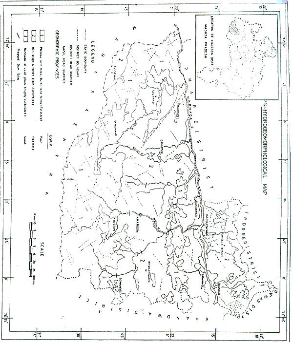
Study Area
Khargone district lies in between longitude E 74 25' to 76 15' and latitude N21' 30 to 22 35'. It covers an area of about 13485 sq. km. and situated on the southern west boudary of Madhya Pradesh. It is bonded on east by Khandwa, on north by Dhar and Indore districts, on west by Jhabua district and on south by Maharashtra state. Narmada is the main river which flows in the district from east to west. The maximum part of the distinct comes under Barwaha, Maheshwar, Kasrawad and Rajpur tehsils. The northern part of the district form the highly fertile land of Narmada basin, while most of the sothern part is ---------------------and comes under the Salpura mountains. The northern part, along the Narmada river is thickly populated, well cultivated and has less forests. However, an area of about 3.71 lack hectares is under reserved forest and about 1.00 lac hect. under unclassified forest. The total population of the district is mainly inhabited by rural people with a ratio of rural to urban population as 85:15. A
griculture: It is the main source of livelihood. An area of 6.60 lac hect. is under cultivation in total geographical area of about 9.77 lac hectares. Jowar, Wheat, Maize and Cotton are the main crops of the area. Sugarcane and vegetables are also grown where good irrigation facilities are available. In Kharif the area under the edible crops is 3.68 lac hectares while that under non-edibel crops it is 2.38 lac hectares. In Rabi these values are 0.54 lac hect. and 0.02 lac hect. respectively for the two types of crops. About 3.71 lac hectares of the area is under forest. There are no dense forests in the southern part of the district. The south western part of the district is occupied by medium to dense forests.
Irrigation: The irrigation measures created in the district from the government agencies till now is very low i.e. about less than 12% of the total cultivable area. There are several local tanks for irrigation. Also 0.44 lac hect. of land is under well irrigation which is roughly 7.8% of the total irrigated land.
Climate: The climate of the district is one the whole is dry except during the South-West monsoon. There are mainly four seasons, the winter season from December to February, followed by Summer season from March to May. The south - west monsoon period which follows thereafter lasts till September. October and November constitutes the post monsoon season.
Rainfall: The precipitation in the area is from the south-west monsoon. The average annual rainfall in the district is 831.5 mm. About 91% of the annual rainfall is received in the period between June to September, July being the month of heavy rainfall ( about 52%). The rainfall in the major portion of the district increases from South to North. In the north west part of the district in Barwani, Rajpur tehsils rainfall is much less than in the other parts of the district. The annual rainfall in the district various between 600 to 1100 mm.
Temperature: May is the hottest month of the year with ave. temp. value of 41C, however, the highest recorded temp. is 47 degree Celsius. The south west monsoon starts from middle of June and Continuous upto end of September. December is the coldest month with daily mean temperature of 11 degree Celsius. During the cold season, in association with the eastward passage of western disturbances across north India, the district experiences spell of cold weather, where the max temperature sometimes go down to a degree or two above the freezing point of water.
Drainage: The district area is mainly drained by the Narmada river and its tributaries. Goi, Beda, Kudi, Borar Dondar, Deb, Nahali and Bhongali rivers flow from south to north while Kharki, Gomathi, Malan and Makeswari rivers flow from north to south in the southern bank of Narmada on the eastern part of the district. Choral is the main river draining into the northern bank of the river Narmada. These major rivers are perennial to some extent and retain some water even during summer months. All the small Nallahs which feed the major streams during the monsoon, Remain dry during summer. The drainage pattern is mostly dendritic to sub-dendritic in disected plateau and hilly area, while it is parallel to sub-parallel in plain area. However, a characteristic radial drainage is observed in the basaltic terrain, south of Segaon and east of Sendhwa in between longitudes E 75 15' to E 75 30] and latitudes N 22 30' to 22 45'. The streams appear to be fractured and joint controled in the basaltic terrain. .
Geology: Geology of the Khargone district based on the visual interpretation of the landsat TM and IRS-1A LISS II F.C.C> shows various formations belonging to different groups of geological settings. Basically the geology is marked by the presence of Recent Alluvium, Deccan traps, Bagh Sedimentaries, Vindhyan metasedimentaries and Bijawar groups. The north eastern part of the Khargone district in the vicinity of Maheshwar, Mandleshwar, kasrawad exhibit Deccan traps showing highly fractured and jointed lava flows with less number of dykes, and linaments. On either side of the river Narmada, the area is dominated by the presence of Recent Alluvium. Adjoining to this area, near Barwaha, Katkut shos three different types of Geological formations. Area around Katkut shows the presence of Bagh sedimentaries which clearly indicate that the geological history was preserved by these formations before the eruption of Deccan traps, which predominantly consist of Bagh sandstones and limestones. Around Barwaha and on the right bank of river Chora, the area is dominated by the Vindhyan Super Group, showing interbedded shales and sandstones. This is a structurally rich area showing the presence of Dykes, faults, fold axes, photo dips lineaments etc. The impure limestone and dolomites belonging to Bijawar Group area clearly visible in the extreme North Eastern part of the Khargone district. One of the major rivers of India "NARMADA" flows through the study area. The non-meandering and Linear courses of the river has created lot of controversies about its existence and flows. later it was found that this river, Narmada flows through a Lineament, namely, "Son-Narmada Lineament", giving recognition to his linear path. In the extreme south eastern part of the area which extends upto south west shows a continuous belt of highly fractured and jointed basaltic lava flows belonging to Deccan traps. The presence of lineaments and dykes is comparatively less in this area. The central part of the study area on the left bank of Narmada river shows the predominance of Deccan traps, with their basaltic lava flows and it is in this area the density of dykes and liniment is very high. The major fault in the study area is the BARWANI fault which extends on either side of the river Narmada. This is clearly seen on the satellite image as a line of demarcation between the two different litho logic formations.
Geomorphology: The study area exhibits varied geomorphic units. Topographically the areas forms a part of the Malwa Plateau and lies between the Vindhyan ranges in the north and disected plateaus in the south. The alluvium plains of the Narmada river lie between 170 to 260 m above M.S.L. The steep slope areas show the gradient between 10 to 12 m/km and gently sloping areas show gradient of 0.4 to 0.7 m/km. Geomorphic units give the brief and synoptic idea of the general topography of the terrain. The whole area exhibits the presence of the fluvial units, showing the presence of alluvium in the flood plains of all the major river systems. The gently undulating plains occupy the major portion of the Khargone district on the south eastern part. Burried pediplains, showing denudational hills occupy the North-Western part of the area on either side of river Narmada. Structural hills can be seen only in the north western part along with the Glacial pediplains belonging to Bagh Sedimentaries. Structural Hogbacks and Cuasta belonging to Vindl. an area damnations -------- to Northern region at the district boundary. Basaltic uplands forming a lower belt extending from west to east in south of the study area forms the major forests in the district.
Results and Discussions
(1) Hydrogeological Setting: The area mainly occupies the Deccan lava flows extension of Malwa Plateau. The Bijwar, Vidhyan and Godarpura. Alluvium occurs in the flood plains of major river courswes on either side. The geological succession of the area is as given below:
Geological Succession of Khargone District
| Formation | Lithology | Age | |
| 1) | Alluvium | Clay, Yellow sandy Kankar Sand and Gravel. | Recent |
| 2) | Deccan trap | . Basalticlava flows with Red boles. | Cretaceous to eocene |
| 3) | Bagh beds. | Corallien limestones and sandstones. | Infra trapear. |
| 4) | Vindhyans. | Sandstones and shales. | Cambrian. |
| 5) | Bijawars. | Massive quartzites Breccia. | Pre-Cambrian. |
(2) Ground Water Occurrence: The brief study carried out which shows that the ground water occurrence in different parts of the area are to a great extent governed by the geomorphic units, and the water bearing properties of different geological formation: The nature, movement and the present status of the development of ground water in different geological units is as under:
- The Bijawars and Vidhyans having massive quartzits Breccia is very hard, compact and have poor permoability. Accordingly there is no ground water development structure tapping this formation.
- Caroline limestone's and calcareous sandstones belonging to bagh beds are also fairly compact.. The formation has as soil cover of about 3 m followed by a weathered zone to a depth of 5 m b.g.l. Ground water occurs under water table conditions at the bedding plains and minor joints.
- Deccan trap, basaltic lava flows are the most predominant and wide geological formations in the area where ground water occurs under semi confined and unconfined conditions. The top weathered mantle which changes its thickness and extent on geomorphologic disposition of the rock forms the zone of unconfined aquifers. The inter- flow contacts vesicular portions of underlying flows, or paleweathered zones between the flows fracture, jointed portion, form the semiconfined aquifers.
- An area of about 500 sq. km. is covered by recent alluvium. where ground water occurs under unconfined conditions and in primary porosity. In general, the quality of ground water is good for drinking and irrigation purposes. However, the concentration of salts is reported more in the alluvial areas. The high salinity and high sodium concentration in soil may be attributed to improper use, contamination of dug wells. The development of thick soil cover results in poor surface drainage.
Conclusions and Recommendations
It reveals from the above mentioned discussion that the Khargone district area has a good unexploited potential of water resources especially of ground water. The intensity of Rabi crops is quite low even though the culturable area is in abundance due to very low rainfall in the non-monsoon period. The drinking water in the area is also tapped through wells although no major municipal water supply scheme exists. Thus, it can be concluded that optimum utilization of available water in the district has not been attempted. The present study suggests that there is adequate scope of enhancing agricultural production in the district and thereby increasing the socio-economic status of the poor people of rural areas i.e. the major population of the district. This objective can be achieved through optimum economic used of surface water, conjunctive utilization of ground water ans surface water and revision of cropping pattern which will include the commercial and cash crops also. Based on the experience gathered in the present study, following recommendations are made:
- Ground water development should be planned through a series of dug wells and tube wells to increase the cropped area of Rabi crops.
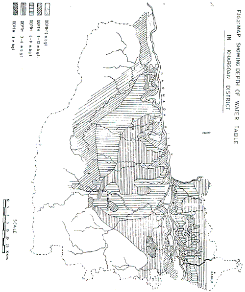
- To make up for the depleted water through wells. check dams at suitable sites marked in Fig. -----------be constructed to provide adequate recharge. These check dams will further help reducing runoff losses from hills areas.
- The check dams should be planned after through geological investigations to avoid possibility of water logging in the area as the water table level is already high in the district (Fig.2).
- The reservoirs created through check dams will provide additional surface water sources, thus planning should be further modified to conjunctively utilize the surface and ground water.
- The integrated planning of these created sources can help in provide a good water supply scheme to meet the Municipal and Industrial demands of the area. Thus , industrialization in ----------area can also be enhanced.
- The existing cropping pattern should be revised to increase the intensity of commercial crop like sugarcane and to further include additional cash crops.
- Regional geophysical survey should be utilized to work out the configuration on deeper aquifers and to find out the thickness of the alluvial sediment as well as permeable zones within the traps.
- Monitoring of ground water levels through a network of observation wells is very essential to monitor ground water development and to assess the ground water balance from time to time.
- Srinivasan K. (1970), Systematic Ground Water Studies in the Hard Rock of Narmada Basin in parts of Khargone District, G.S.I. Report ( 1970-71).
- Srinivasan K. ( 1972), Systematic Ground Water Studies in the Hard Rock Area of Narmada Basin in parts of Khargone and Khandwa Districts, M.P., G.S.I. Report * 1972).
- Government of M.P. ( 1983), Detailed Project Report of Omkareshwar Multipurpose Project, Volume III.
- Central Ground Water Board, Ministry of irrigation, G.O.I. ( 1982), Hydrogeology of Khargone District of Madhya Pradesh.
- Tandale T.D. ( 1990), Resources Data Integration for water Resources Planning and Development at District Level, Paper published in the Proceedings of National Symposium on "Water Resource Conservation, Recycling and Reuse", held at Nagpur, 3-5 February. 1990, pp 97-101.
- Mehta H.S., R.K. Shrivastava, R.S. Sidhu ( 1991), Application Remotely Sensed data for Ground Water Development and Recharge ( A Case Study ), Paper submitted for promotion in the Afro-Asian Conference to be held in Bombay in November, 1991.
Authors would like to express their sincere thanks to Dr. J.P. Shrivastava, Director GSIT & Sc Indore (M.P.) INDIA, for providing the facalities in carrying out this research work.