| GISdevelopment.net ---> AARS ---> ACRS 1991 ---> Water Resources |
Selection of Priority areas
in watersheds using Remote Sensing techniques
V. V. N Murty,R. P. W.
Patabendege,A. Eiumnoh,K. Nualchawee
Institute of Technology GPO Box 2754, Bangkok 10501, Thailand
Institute of Technology GPO Box 2754, Bangkok 10501, Thailand
Abstract
In the watersheds of large reservoirs, soil conservation works are planned both to improve the land resources as well as to control the sediment inflow into the reservoir. Because of the size of the watersheds involved, it becomes impracticable to treat the entire area. Priority areas are to be selected for implementing soil conservation programmes. In this study, a methodology based on the concept of the subwatershed and Remote Sensing techniques is presented to selecte priority areas in large watersheds. The methodology is demonstrated for a selected watershed in Sri Lanka. For the Remote Sensing application SPOT HRV data was used and the same was processed for interpretation using a software package of Earth Resources Data Analysis System (ERDAS).
Introduction
A watershed is an area from which runoff, resulting from precipitation, flows past a single point into a large stream, a river, lake or an ocean. The terms watershed, catchments area or drainage basin are used in the same sense. A watershed may be only a few hectares as in case of small ponds or hundreds or square kilometers as in case of rivers. All watersheds can be divided into smaller subwatersheds. As each watershed or subwatershed is an independent hydrological unit, any modification of the land used in the watershed or subwatershed will reflect on the water as well as sediment yield of the watershed. Watershed management or protection implies the proper user of al land and water resource of a watershed for optimum production with minimum hazard to natural resources. The different objectives of a watershed management programme are ; (1) to control damaging runoff, (2) to manage and utilize runoff for useful proposes, (3) to control erosion and effect reduction in the sediment production, (4) to moderate floods in the downstream areas, (5) to enhance ground water storage wherever applicable, and (6) appropriate use of the land resources in the watershed and thus developing forest and fodder resources.
In the recent past in several Asian countries watershed management projects have been initiated for the purpose of improving land resources and control sediment inflow into major reservoir subsystems (Mahmood, 1987; Murty 1985).
Presented at the 12th Asian Conference on Remote Sensing, at International House of the South East Asian Minister of Education Organization, Singapore, October 30 – November 5, 1991
Concept of Priority Areas
In a watershed management programme, particularly in case of large watersheds it may not be possible to treat the entire area of the watershed with land treatment measures. In such cases, the watershed should be divided into subwatersheds (Fig. 1) and subwatershed which need treatment should be identified. The methods used for determining the priority of the subwatersheds for treatment from soil erosion and sediment yield point of view are : (1) reconnaissance surveys, (2) soil and land use surveys, (3) sediment observations, and (4) Remote Sensing methods.
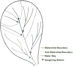
Fig. 1 Division of watershed into subwatersheds
A reconnaissance survey of the entire watershed gives an idea of the relative erosion status of the subwatersheds. This procedure is approximate and is to be used when no other method is available. Detailed soil and land use surveys include the erosion information of the subwatersheds. A careful interpretation of these reports could provide information on the relative erosion status of the various subwatersheds. The main difficulty with soil survey is that it requires much time and personnel.
Actual measurement of the silt load contributed by each of the subwatersheds will give a clear picture of the extent of erosion in the subwatersheds. Observations in respect of silt loads recorded over a period of three to five years will indicate the subwatersheds which are contributing higher silt loads. The main difficulty with this procedure is that the data has to be collected over a period of years so that reliable conclusions can be drawn.
Remote Sensing techniques consisting of satellite imagery and its interpretation offer a good scope for determining the priority areas in large watersheds. In this study, a procedure for interpreting the satellite imagery for the purpose of determining the priority areas is presented. The procedure is illustrated with a case study in Sri Lanka.
cription of the Study Area
A watershed of the Mahaweli river at Hanguranketa in the Central Province of Sri Lanka was selected for this study. The area is about 375km2 encompassing a wide range of farming systems and natural vegetation. The elevation of the area varies from 300 m to 1,500 m above sea level and the topography is moderate to steep slopes. The area is subjected to relatively severe soil erosion which is causing not only land degradation but sediment production. The objective is to identify independent subwatersheds in which conservation measures are to be implemented on priority basis.
Development of Thematic Maps
For the study area, thematic maps viz., slope map, iso-erodent map and soil erodibility map were developed. The contour map to a scale of 1:63, 360 with 500 feet contour intervals was a used as the base map. The area was divided into five slope categories viz., 0-8%, 8-16%, 16-30%, 30-60%; more than 60%.
For developing the iso-erodent map, 17 non-recording type raingague data in the study area was used. Using the men annual rainfall and rainfall aggressiveness index, the following regression model was used to calculate the mean annual erosivity (Patabenge, 1990)
MAE = 6.62 MAR + 92.32 RA - 11754.49
Where
MAE = Mean annual erosivity in joures per m2,
MAR = Mean annual rainfall in mm, and
RA = Rainfall aggressiveness index
Soil erodibility was estimated using the approach given by Wischemeier et al. (1971). The following regression model was used for estimating the soil erodibility.
SE = 0.00014 S + 0.0035 SIVFS – 0.0625
where
SE = Soil erodibility
S = Percentage of sand, and
SIVFS = Silt plus very fine sand percentage
Soil samples collected at 20 locations were analysed and the soil erodibility values were estimated. Depending upon the numerical value, soil erodibility classes were divided into 7 groups.
Image Processing
SPOT HRV data in digital form covering the study area for a cloud free day on 26th August, 1986 was obtained form the Victoria Land use and conservation Project (VLUCP).
Processing and interpretation of the data were conducted with a personal computer (NEC-APC-IV) using a software package of Earth Resources Data Analysis System (ERDAS) available at the Remote Sensing Laboratory of the Asian Institute of Technology (ERDAS Developed by ERDAS Inc., Atlanta, Georgia, USA). The steps in the analysis followed are shown in fig. 2.
There were a wide range of problems encountered that influenced the accuracy of the results. Land use changes occurred during the image acquisition data (August, 1986) and the ground truth collection date (August, 1990). Small land holdings, which generate the spectral reflectance value of mixed land use cause lower accuracy.
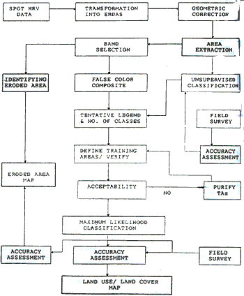
Fig. 2 Block diagram for digital image processing
Digitizing Maps in to “ERDAS”
In this process, the developed map of erosivity erodibility, and slope geo-referenced to the universal transverse Mercator (UTM) coordinates using the 1:63,360 scale base map. The UTM coordinates of the upper left corner are 195400 and 231900.
The number of classes were set to 5 in erosivity and slope maps and 7 for the erodibility map. The thematic maps were digitized separately in the form of polygons using the DIGPOL Option in ERDAS. The digitized maps were transferred to GIS files which is the compatible form the GIS analysis by employing GRDPOL program.
Priority Subwatersheds
18 subwatersheds within the study area were delineated on the 1:63,360 contour map in order to assess the nature of erosion hazard in each unit. The delineated subwatersheds boundaries were digitized into ERDAS along with the drainage network of the study area. The digitized map of subwatersheds and drainage network of the study area. The digitized map of subwatersheds and drainage network was transferred into a GIS file using the GRDPOl option and then overlaid with eroded area map to investigate the erosion level at individual subwatershed. The number of pixels belonging to each category of water, no erosion, low erosion, and high erosion were counted. Factorial scores were assigned to each category giving their erosion potential.
A quantitative estimation of erosion hazard at each subwatershed was achieved by introducing the factorial scores to the number of pixels at each category. The numerical values obtained were normalized to 100 and the priority subwatersheds were identified accordingly. The schematic block diagram showing the steps of overall methodology is shown in Fig. 3. The factorial scores and respective erosion hazard categories area presented in Table 1.
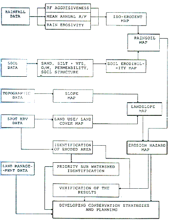
Fig. 3 Block diagram for mehtodology
Table 1 : Factorial scores of erosion hazard categories
| Class Number | Erosion Hazard Category | Factorial Score |
| 1 2 3 4 |
Water No erosion hazard Low erosion hazard High erosion hazard |
0 0 2 4 |
Table 2 : Priority values of the subwatersheds
| Priority Value | Subwatershed Identification No. | Priority Value | Subwatershed Identification No |
| 01 02 03 04 05 06 07 08 09 |
02 15 01 08 10 11 18 14 12 |
10 11 12 13 14 15 16 17 18 |
07 09 05 03 16 17 04 06 13 |
Conclusions
In this study interpretation of a satellite imagery is used to identify priority areas for soil conservation works. The procedure uses the information on soil erodibility, land use and land use cover, and prepares an erosion hazard maps. The erosion hazard map is used to determine the priority watersheds for soil conservation works. The procedure can be adopted when satellite imagery and its interpretation facilities area available. This could be useful when planning soil conservation measures in relatively large watersheds.
References
Mahmood, K. (1987) Reservoir Sedimentation, Technical Paper No. 71, The World Bank, Washington D.C.
Murty, V.V.N. (1985) Land and water Management Engineering, Kalyani Publishers, New Delhi
Patabendege, R.P.W (1990) Developing Conservation Strategies and Planning for the Sustainable Utilization of the Land Resources at Hanguranketa, Sri Lanka, M.Sc. Thesis, Asian Institute of Technology, Bangkok.
Wischmeier, W.H. Johnson, C.B. and Cross, B.V. (1971) A soil Erodibility Nomograph for Farmland and Construction Sites, Journal of soil and water Conservation, 26, 189-193.