| GISdevelopment.net ---> AARS ---> ACRS 1991 ---> Poster Session 2 |
Design and Compilation of
Color Landsat Map of China
Zhang Shengkai, Xia
Mingbao, Shi Junmei
(Chinese Academy of Sciences, Beijing 100101, China)
(Chinese Academy of Sciences, Beijing 100101, China)
Abstract
The color Landsat Image Map of China has been compiled on the scale of 1:1,000,000, which consists of 584 scenes of Landsat MSS imagery acquired in 1970's. reasonable mapping design and multiple optical processing methods are used. The map has concordant color and macroscopic characteristics, which shows lively the physiographic outlook of China. It has vast applied and academic value.
Introduction
The compilation of color Landsat image Map of China has been successfully finished on the scale of 1:1,000,000 based on accumulation of science and technology, and experience and data over several years. It is the largest color mosaic map in China with 4.5 m high and 5.5 m wide. Reasonable mapping design and multiple optical processing methods are used in compilation. The objectives of compilation are for systematically study of the development and evolution of physiographic and environment in China, the interaction of natural elements, the relationships between environments and economic development, and for developing natural resources reasonably and setting up better eco-environment.
The characteristics of the map, the compilating procedure and the scientific value have been described in this paper.
Design Characteristics
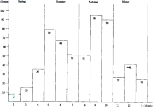
In the image map it is important to show comprehensive multi-elements of natural environment as whole so as to be used for analyses and dynamic comparison in multi-disciplines. Landsat MSS images acquired in 1970's are basic data for compilation. Land cover is the main factor reflecting the differences of regional features, which can be displayed directly by spectral information of Landsat images. Hence, images acquired mainly in summer and fall are selected, which 74.3% of the total images used (fig. 1).

Fig 1 Statistical analysis of imageing time of Landsat MSS Data
With regard to the control basis, the Lambert conformal conic projection is selected to use, which can display the territorial integrity and geometric consistency of China. A transition method with mathematical accuracy and operational convenience is designed as follows : image sin single scenes are mosaicked based on topographic maps at 1:1,000,000 scale, then they are mosaicked on the Lambert conformal conic projection at the same scale, the linear correction transformation bound up with latitude is sued so as to share the error equally.
The decoration and arrangement is designed for simple, magnificent and concordant appearance. It is not only convenient to interpret, but also it has aesthetic value.
As mentioned above, rules are considered not only geosciences and biology, but also of cartography and Remote Sensing technology during the compilation of the Landsat image map. In con- tains abundant comprehensive information. Therefore, the image map can be regarded as a combination of the map and image, the science and art, which could be used for study, applications and appreciations.
Completion Techniques
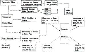
The Landsat Image Map of China is compiled by color composite of 584 scenes of Landsat MSS data, controlled-mosaicking and mapping decoration. The compilation technique is complex for this image map. Image data and related maps are collected. Characteristics of mapping regions are analyzed. Then a practical compilation techniques is designed (Fig. 2).

Fig 2 Flow chart of the compilation technique
Control Basis
In order to mosaic 584 scenes of images with high precision, images of single scene are mosaicked based on each separated topographic maps at 1,1000,000 scale, then they are mosaicked to form 15 pieces of image map. Thereby, the total errors is divided into local errors and are shared in each of the 15 pieces. The regional precision is satisfied. The color negatives of 15 pieces of images map are then formed. Corrective exposure are carried out using E4 corrective Apparatus, based on conformal conic projection at 1:2,500,000 scale as well as a number of control points. Finally, the image map at 1:2,500,000 scale are mosaicked with high precision.
Color Composite
It is difficult to harmonize the tone of the nearly 600 scenes of images. So it is necessary to analyze the environmental factors influencing image tone, to make main vegetation regions with similar tone, to selection high-quality images with similar imaging time.
On the basis of the three primary color composite principle, the relationships between image density (transparency), spectral reflectivity of objects and composite tone are studies. It s shown that difference in transparency of multi-spectral negatives is the inherent factor of color variety. Images with varied color can be obtained by adjusting exposure time o different negative, or by changing the ration of layered-exposure time.
The density and contrast of neighboring images are different for the different imaging area, time and illumination conditions. In this case, quantitative measurements are carried out for determining the best composite condition. Contrasts of some images are so small or so large that it isn't useful if composite exposure condition is adjusted only. So, some optical treatments will be carried out, such as copy rendition, correlated overlap, color cover and so o so as to adjust the density contrast of original images. With regard to the color concordance of the whole image map, the macro-appearance is focused on, that is, the natural transformation of neighboring images and the overall color concordance.
Controlled Mosaicking
The transparent sheets to topographic maps are made at first. Then, put them on the images and control the image potion by distinctive objects like the drainage patterns. The identical objects on the images must overlap those on the sheets. If the error of object overlap is large, it is necessary to overlap important image features so as to share error equally.
Fig 3 The Plane - Cut intersect technique
Mosaicking are carried out radially based on the transparent sheets so as to get rid of error accumulation and map distortion. It is important not only to have higher geometric precision, but also to have color concordance for color image mosaic. Hence, the object connection errors are limited as small as possible during mosaicking while the object tones are transformed harmonically.
Characteristic of the image map and its application
Since attention are paid to the color concordance and cartographic technical treatments, there re no distinct connection lien and tone difference between images, the map is clear in tone, concordance in color, medium in contrast, few of clouds. It shows lively the dramatic geomorphic scenes over the China. The information provided by the map ahs potential for applied analysis of interdisciplines. It provides a new means for global and national studies.
Tectonic Study
The geologic and geomorphic texture, linear and circular features are distinctive at the image map, which provide audio - visual evidences for tectonics. It can be used for analysis of distribution of geologic body, delineation of mineral - bearing structures, providing an efficient tool of exploration of mineral and oil and gas.
Natural environment study and development of Eco-Agriculture
Abundant information in near-infrared spectrum are displayed at the image map, which shows vividly the distribution of landcover. The eastern China is red on the image map, where the eco-environment is good, and there are such renewable resources in the west and northwest China, regions in blue-green are deserts and gobi regions. The farmland and forest are very few. Soil erosion in the less plateau is severe. Adverse eco-environment and natural ecological condi- tion are recognized on the image map. The image map provides maps for land - planning, regional planning, counter- measurement of soil erosion, reasonable development of natural resources, protection of eco-environment and so on.
Study on Evolution of Environment
The image map reflects the geographic environment in 1970's. By comparison with data acquired by new sensors developed in 1990's such a Landsat 6, MOS-1 (Japan), Resource Satellite (China), dynamic analysis can be carried out of change of drainage, land use, deforestation desertification, salinization and so on.
Academic Exchange
The Landsat Image Map of China will be published at 1:1,500,00 and 1:2,50,000 scale with Chinese and English attributes, in accordance with requirements of International Space Committee. As is Chinese part of the Global Landsat Image Map in the International Space Year, it will be presented in the international Space Year Activity in 1992.
Acknowledgements
This maps has an editional committee with Prof. Chen Shupeng as advisor in science and technology and 18 experts as members, including Profs. Tong Qingxi, Zheng Lizhong and Zhang Qijuan. Profs. Zheng Wei, Chen Zhengyi provide guidance and assistance for this paper. The authors would like to express their thanks to all of them.