| GISdevelopment.net ---> AARS ---> ACRS 1991 ---> Poster Session 2 |
Mapping from space with
photogrammetric instruments from Leica
A Stewart
Walker
Leica Heerbrugg AG
Branch Uninterentfelden
Photogrammetry and Metrology
Leica Heerbrugg AG
Branch Uninterentfelden
Photogrammetry and Metrology
Abstract
The possibility of mapping from space imagery, especially SPOT and LFC, has been incorporated on many of Leica's analytical and digital stereo plotters, a chronology of which is given. Leica's entry level digital photogrammetric station, the DVP Digital Video Plotter, the simplicity and price/performance of which ensure its appeal in many market places, is described. The paper concludes with an outline of use of SPOT imagery on the DVP as well as Kern DSR and DSP1 and Wild ACI and BC product lines.
Introduction
A popular, successful and accepted method of data acquisition for GIS databases is the photogrammetric compilation of vector data from strereopairs of remotely sensed imagery, normally aerial photograph but also satellite images, especially SPOT. The founder companies of the Leica group have a fine photogrammetric pedigree. Kern have been manufacturing photogrammetric equipment for 30 years and Wild, later Wild Leitz, for over 60. Between them, these companies accumulated an enormous share of the market for analogue stereoplotter, which enjoyed great success, reaching their zenith in the 1960s and 70s, until analytical plotters began to supersede them in large number in the 1980s. The latter are better suited to Remote Sensing applications since their handling by means of software of different formats and geometries enables a much wider range of imageries to be restituted. The process to gradual replacement of analogue by analytical stereo plotters throughout world mapping seems likely to continue until the end of century.
Leica photogrammetry in recent years
While analogue instruments like the Kern PG2 and Wild A8 and B8 are known to all, it is worthwhile briefly to summarise the development of analytical stereoplotters within the Leica company. In 1980 Kern introduced the DSR1 at the XIV ISP congress in Hamburg. This instrument and its GP1 plotting table pioneered the use of distributed micro processing, as opposed to total dependence on a host computer. At the same time Wild launched their AC1, a high performance instrument featuring a dramatically modern but aesthetically pleasing viewing device. Two years later came the BH1, a lower cost model, and in 1984 Kern also achieved a cost reduction with the DSR11 while Wild Introduced an update, the BC2. In 1986 Wild added the S9-AP, a photogrammetric workstation for their system 9 GIS which incorporated stereoscopic superimposition of the photographic images and database information.
There followed a rapid series of events which began with the purchase of Kern Aarau AG by Wild Leitz Holdings AG in May 1988. Two months later, the analytical stereoplotters DSR 12/14/15, together with the digital stereoplotter DSP1, were launched at the ISPRS congress in Kyoto. The DSRs were differentiated by their different host computers, PDP-11, personal computer (PC) and VAX. KRISS (Kern Raster Image Superimposition System) was offered as an and a Unix host. The range of software offered with these instruments reflects the trend towards off-line or on-line linkages to destination CAD or GIS systems. Interestingly, three of the analytical plotters came also in versions with large stage plates, the BC1S, BC2S and DSR15-18. Whilst one intention of these variants was the restitution of imagery from the large format camera and other special devices for data acquisition, it must be remembered that they are also designed for on-line comparisons between two stereomodels in field like forestry and glaciology.
In 1990, a merger took place between Wild Leitz Holdings AG and Cambridge Instruments Ltd to form Leica plc and early in 1991 the announcement was made that the factory in Arau would soon close, with photogrammetric manufacture being moved to Heerbrugg and product management and research and development, to a new business unit, which would be located in Unterentfleden, a suburb of Aarau, and would be part of Leica Heerburgg AG. By this time, the DVP, an economical, entry level digital photogrammetric station aimed at wide, new market segments, had entered the product line, as has RISIS, the Raster Image Superimposition triumphant launch at the ASPRA/ACSM Convention in Baltimore of its new analytical plotter SD2000 (Cogal et.al. 1991). The commitment to good communications with CAD and GIS systems and SD2000 with direct to connection to the GIS INFOCAM. The RC20 aerial camera and the range of stereoscopes have been relatively unaffected by these changes and continue to be developed, devices from the former Bausch and Lomb factory in Rochester, USA now emanate from a Leica business unit called image interpretation systems Inc.
The most recent milstone was the signing in July 1991 of a Memorandum of Agreement between Leica and General Dynamics. This will enable the two companies t work together and in particular, will promote the distribution through the Leica networks, to the civilian market, of digital photogrammetric products from HAI inc. a General Dynamics subsidiary. These products will play significant role in the photogrammetric processing of remotely sensed imagery.
Digital photogrammetry in Leica and the DVP
In contrast to the DSP1, which was Leica's first venture into digital phoyogrammetry and is a high performance solution aimed at specialist markets (COga et al. 1988), the DVP is an economical digital photogrammetric station which runs on an ordinary PC. It makes no attempt to pan the images, in other words the real time movement is limited to the measuring marks. Thus an inexpensive graphics card with only 512K RAM suffices. It could be classified as an instrument which is based on "off the shelf" components (Grun 1989; Lohmann et al. 1990). In a classification based on performance and functionally, Dowman (1991 p4) judges the DVP as a digital photogrammetry workstation with "limited performance and functionally but low cost".
It is worthwhile reiterating the merits of digital photogrammetry: working with digital images on standard computer displays with familiar user interfaces rather than complex, expensive arrangements of optics and mechanics; image processing and automation to facilitate measurement and information extraction; increased operator convenience, for example no instrument calibration, no parallax between superimposition of digital map data at little additional cost. Photogrammetric work with digital images is crucial in Remote Sensing, where so much of the imagery is digital at source and the production of film images may result in small fields of view on the screen; real time panning is feasible but the hardware requirements are demanding, so the DVP offers the simpler, cheaper option of stationary images and moving measuring marks; disk space is rapidly absorbed by digital images and archiving facilities must be provided.
Most data for mapping is still captured on film with aerial cameras and must be scanned. The ideal scanner would have a format which can accommodate 230 x 230 aerial photographs in the form of negatives, diapositives or prints, in color or black and white, with a resolution of low cost scanners in the PC and desk top publishing worlds are usually A4 format and/or too low purposes, but high performance models such as the Zeiss (Oberkochen)/Intergraph PS1 PhotoScan, Rollei RAS1 and Vexcel VX2000/3000 are now available. Between these two groups of scanners are the Rank Xerox 7650 and sharp JX-600, each advertised as being 600 dots per inch (pixel size 42 micrometers), A3 format and capable of outputting in TIF format. Both have been successfully used with the DVP. Whereas the Xerox is restricted to prints, the Sharp accepts negatives and diapositives too and is color, albeit more expensive and slower in operation.
Finally, there is a process of education : personnel in the new markets on which the DVP is targeted are familiar with computers but not photgrammetry, so a digital solution is ideal, but the traditional photogrammetric community may find it awkward to adapt to the new technology. Moreover, it is not easy to improve on the performance of the combination of aerial camera and analytical stereoplotter for routine collection of topographic data.
The DVP Digital Photogrammetric Station
The DVP Digital video plotter (fig. 1) is an entry level digital photogrammetric station which is based on a standard PC (Agnard et al 1988; Gagnon et al 1990; Gagnon et al 1991). The software was written, as a tool to help train students, in the Department des sciences geodesiques et de teledetection of universite laval, Quebec, Canada. In 1989, the commercial distribution was undertaken by a local land survey enterprise, geomatique EMCO, which in 1990 formed a new company, les systems photogrammetriques DVP Inc., to concentrate on this operation. In mid 1990, DVP approached Leica Aarua AG, which assumed sole exclusive rights to distribute the product in November.
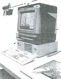
Fig 1 DVP digital photogrammetric station
The DVP runs under MS-DOS or PC-DOS on a standard 80 x 86 PC or PS/2 with a low cost graphics card and multisync monitor. The screen resolution is 800 x 600 or 1024 x 768 on the PC with ATIVGA Wonder or ultra graphics cards respectively or 1024 x 768 on the PS/2 with an IBM 8515 card. The image files are in TIFF format and contain 256 grey levels, with in the case of the ATI wonder card, a mapping to 64 for display. Refresh take around 10 seconds on a PC with a reasonable disk controller and a small cache is created in RAM by the DVP software. Image processing is not offered, but several low cost grey scale editors are on the market which users could employ to "front end" the DVP.
As explained earlier, there is not image planning. For comfortable stereoscopic viewing, the measuring marks move in the orientated model such that they always have equally coordinates on the screen. Consequently, the right hand image is refreshed whenever the required image displacement exceeds half a pixel. Window selection and XY movement in the images are performed by means of a Summagraphics Summa Sketch or compatible tablet, continuing the emphasis on standard, economical components, through of course a large hard disk and an archiving device such as a tape cartridge, drive essential. The half screens are viewed through a simple optical system. The windows selected by means of a paper print on the digitizing tablet are confirmed on a small reference diagram at the bottom of the screen (lower right in fig.2). A function to display new windows diagram centered on the current position of the measuring marks is available too. All commands can be issued through either the PC's keyboard or cursor buttons on the digitizing tablet. Z movements in the stereo model are controlled from the keyboard.
Fig 2 DVP screen layout during data collection
The operations for workstation setup, orientation and data collection with two color stereo superimposition are standard, but naturally there are fewer options, menu selections and displays than with the software on other Leica steroplotters. A 2x zoom is implemented as an aid during orientation and rudimentary image matching function can be chosen during relative orientation. DVP adhere to the philosophy of uncomplicated, productive data capture (fig.2), after which the data are translated into the format of powerful CAD or GIS systems for further work, namely ARC/INF, AutoCAD or MicroStation. Two may translators are available so that existing data files can be brought to the DVP for stereo superimposition. A more sophisticated ARC/INFO translator is available from ESRI Canada. The DVP has also been integrated with both Kork and Terra-Mar software products and integration with AMSA is imminent.
The objective of the DVP is to provide photogrammetry to a wide potential userbase which in the past has been discouraged by either complexity or cost: land surveyors; environmental managers, in areas such as agriculture, forestry, and open cast mining; the GIS and Remote Sensing communities; planners in municipalities and utilities; geologists and geographers; architects. The price of the DVP, its use of commonplace hardware and the fact that its operations emulate those of atypical analytical stereoplotter render it an ideal training tool.
Tests have been encouraging (Gagnon et al. 1991; Nolette et al.,1991). With wide angle photographs taken with 60% overlap at scales between 1:5000 and 1:40000 and scanned at 450 dots per inch, the results shown in table 1 were obtained. In all cases, relative and absolute orientation were performed with ten well distributed points and there were 20-50 checks points. The results mean that root mean square errors in X or Y at well defined check points were about half pixel size. The planimetric accuracy is around 0.7 pixel size and height accuracy has proved to be much the same. Experiences within Leica confirm that these results are representative.
| Model | Rmse on check points (micrometers) | |
| Planimetry | Height | |
| 1 2 3 4 5 mean |
34 40 45 42 50 42 |
35 34 35 42 33 36 |
Restitution of Spot Imagery
A version of the DVP for restitution of panchromatic stereo pairs of SPOT imagery is almost ready. It is interesting to review the application of the various work station in the Leica range to this problem. By 1987, work was already in progress on SPOT software destined for seven workstations-AC1, BC1/2, DSR 11/12/15 and DSP1. In all cases, it was destined for seven level 1A imagery. Kern drew on work by Gugan (1987,1988), using the collinearity equations but allowing the parameters to vary through time, in other words in accordance with the y coordinate on the image. The ephemeris data were introduced in order to give the solution good initial values. The real time loop was based on the same model, necessitating the use of amore powerful real time processor in the DSR11 on which the initial work was done. The SPOT software ran first on the PDP host computer of the DSR11/12, then was ported to the VAX of the DSR 15 and DSP1. probably the best known project for which the product was used is the mapping work by the British in north Yemen (Hartelney 1988; Murray and Farrow 1988).
At the same time, Gugan's ideas were used by Aviosoft to write SPOT modules for the AC1 and BC1/2 stereoplotters. Here the solution was obtained in a similar way to the Kern product, but the real time loop differed significantly. Discrepancies between a SPOT image with the computed orientation parameters and a central perspective image with the same parameters were calculated for two Z planes and used to form 15 x 15 correction grids for the computation, via bilinear interpolation, of the image coordinates. The same approach was employed for the BC3 module, which was introduced in 1989 with the advantage of total integration with the MAPCE software for data collection. Meanwhile, researchers in Australia (Trinder et al. 1988) had prepared an alternative module for the BC2, albeit with much less ealborate software for data collection that the Wild product. The solution was again a modification of the collinearity equations, with the coordinates of the perspective centre varying as a first order. The real time loop was implemented by dividing the image into segments, each with a different, but conventional, central perspective image coordinates within each segment could then be corrected by means of second order polynomials in the image coordinates.
The algorithm used in the DVP, based on the work of Toutin (1985, 1986), employees a complex series of transformations, including the collinearity equations befitting also from theoretical work in celestial mechanics. The implementation of the DVP and the formulation of the real time loop will be described in future papers by the team from Laval University.
New directions for the DVP
In addition to a SPOT version, DVP are working on other new products. A module for plane rectification is available and will soon be joined by data collection for aerial triangulation (Agnard and Gagnon 1991), DTMs, coordinate geometry (Gagnon et al. 1991) and orthophoto computation. In addition to new developments, steady progress is being made in refining the basic product and the next release will encompass useful improvements to screen refresh, model set up, synergy compensation for radial lens distortion and data collection. Equally, there is scope for synergy with Leica, since work in which the latter has been involved in the areas of hardware acceleration and automation may be adapted to the MS-DOS environment.
Conclusion
After some introductory material on Leica and a chronology of its analytical workstations, including notes on the provision of SPOT software or large stage plates to facilitate Remote Sensing applications, the DVP Digital Video Plotter has been presented. It evidently meets its objectives of furnishing a broad customer base with an economical digital photogrammetric station based on a standard PC. Further refinements and new modules will certainly establish the DVP as a most attractive product for a data collection and revision by photogrammetrists and non-photogrammetrists alike. The price, the imminent launch of a SPOT module and the interfaces to popular CAD and GIS products ensure that the DVP will interest the Remote Sensing world.
Acknowledgements
The author is grateful to colleagues at Leica Aarau, Leica Instruments Pty, Aviosoft, DVP Photogrammetric Systems and Laval University for material and discussions which have provided part of the content of this paper. Product names used in this paper are trademarks of their respective manufactures.
References
- Agnard, j.P. and Gagnon P.A., 1991. PC-based digital block adjustment, Technical Papers, 1991 ACSM-ASPRS Annual Convention, volume 5, Photogrammetry and Primary Data Acquisition, 7-10.
- Agnard, J.P. Gagnon, P.-A, and Nolett, C., 1988. Microcomputers and photogrammetry - a new Bouilianne, M., Ganon, P.-A, Agarnd, J.-P and Nolette, C., 1990. Large-Scale map revision using a PC-based video plotter, International Archives of Photogrammetry and Remote Sensing., 2 8 (4) 273-279.
- Cogan, L., Gugan, D., Hunter, D., Lutz, S. and Peny. C., 1988. Kern DSP1 - digital Stereo Photogrammetric System, International Archives of Photogrammetry and Remote Sensing, 27 (B2) 71-83.
- Cogan, L., Hinsken, L., Kolbusz, j., and Walker, A.S. 1991. SD 2000 - analytical workstation and 3D digitizer, spatial data 2000, oxford, 17-20 September.
- Dowman, I.J. 1991. digital Photogrammetric systems in North America, Report to ISPRS Intercommission working Group II/III, 5 pages.
- Gagnon, P.-A, Agnard, J.-P, Nolette, C. and Boulianne, M., 1990. A microcomputer based general photogrammetric system, Photogrammetric engineering and Remote Sensing, 56 (5) 623-625
- Gagnon, P.-A, Nolette, C., Agnarg J.-P. and Larouche, C., 1991. Extending the field of the surveyor's practice with PC-video photogrammetry, conference of commonwealth Surveyor's Cambridge, 5-17 August.
- Grun, A., 1989 , Digital photogrammetric processing systems : current status and prospects, photogrammetric Engineering and Remote Sensing 55(5) 581-586.
- Gugan, D.J., 1987. Practical aspects of topographic mapping from SPOT imagery. The photogrammetric record, 12 (69) 349-355.
- Gugan, D.J., 1988. Topographic mapping from SPOT imagery with the Kern DSR analytical plotting system, Geodetical Info Magazine 2(2) 19-21.
- Hartley, S., 1988. Lien mapping from satellite in the Yemen Arab Republic, land and Minerals Surveying, 6(9) 468-471.
- Lohmann, P., Luken, C. and Picht, G., 1990. digital Photogrammetric workstations, international archives of photogrammetry and Remote Sensing 28(2) 283-294.
- Murrya, K.J. and Farrow, J.E. 1988. experiences producing small scale line mapping from SPOT imagery, international Archives of photgrammetry and Remote Sensing, 27 (B11) IV407-IV421
- Nolette, C., Gagnon, P.-A. and Agnard, J.-P., 1991. DVP the digital videoplotter developed at Laval University, Workshop, Design Issues of Softcopy Photogrammetric workstations, Boulder, Colorado, 21-22 March.
- Toutin, Th., 1985. analyse mathematiqu des possibilities cartogrpahiques du system SPOT, Revue de l'Association Francase de Topographic, 25, 54-66.
- Toutin, Th., 1986. Etude Mathematique pout la rectification d'images SPOT, Proceedings of XVIII international congress of surveyors, 379-395.
- Trinder, J.C.. Donnelly, B.E. and Keong, K.L. 1988. SPOT software for Wild Aviolyt BC2 analytical plotter. International arhives of photogrammetry and Remote Sensing 27 (B4) 412-421.