| GISdevelopment.net ---> AARS ---> ACRS 1991 ---> Poster Session |
Sediment yield prediction
& prioritisation of watershed using Remote Sensing data
A.K.
Chakraborti
Water Resources Division, Indian Institute of Remote Sensing
Dehradun 248 001, India
Water Resources Division, Indian Institute of Remote Sensing
Dehradun 248 001, India
Abstract
Decision configuration of watershed management required scientific knowledge of resource information, expected sediment yield and priority class of watersheds for conservation planning. Satellite data is ideally suited to derive spatial & temporal information of watershed cover types which can be inputs to sediment yield model (S) & watershed prioritization scheme. A methodology has been evolved through application of Landsat TM FCC image and empirical sediment yield model, in a case study in Doon Valley in India, to predict sub-watershed-wise sediment yield rate and to prioritize these watersheds based on frequency distribution of data ranges. Such a method will be of immense value for conservation planning where observed sediment yield data are sparse.
Introduction
Basic technological ingradients to arrive at management decision by ascertaining scientific enquiries about where one should look-in for watershed conservation (critical watershed ?, conservation priority?, how much money & effort to spend ?) can be best judged if we have the following information :
- Physical resources information of watershed.
- Modelling sediment yield from watershed.
- Prioritisation of watershed for conservation planning.
In many instances in the past, non-availability of physical resources information of watershed was a major handicap in planning processes and management decisions.
Many of our storage reservoirs had thus been constructed with inadequate watershed data which later showed actual sediment yield much in excess of their design capacities. Continuous availability of data from an array of land resources satellites for the last two decades (Landsat since 1972, SPOT & IRS 1987 & 1988 onwards) has narrowed down these information gaps and may of watershed’s management questions can now be suitably addressed to find solution. Experience has shown us that satellite data can be interpreted to derive a number of thematic information in landuse, soil, vegetation, surface water, snow cover, stream network, landform, erosion intensity etc. which combined with conventionally measured climatic parameter (precipitation, temperature, evaporation etc.) and topographic parameters (height contour, slope) should provide meaningful synthesis of information of a watershed.
I.1. Sediment Yield Model
A number of sediment yield models, both empirical and conceptual, are in practice to address wide ranging soil and water management problems. Most conservation planning for erosion control, however, use empirical model(s) to estimate average annual soil loss. Investigation into such empirical models reveals that most of these models require input parameter in terms of spatial information of landuse, vegetation cover, soils, slope, drainage density, besides runoff and rainfall intensity. One such empirical model, under Indian conditions, which is of-late quoted in literature (Kumar, 1985, Rao & Mahabaleswara, 1990) is as follows:

Examination of this regression reveals that parameters like A, D, S and Fc are essentially mapping inputs which can be conveniently derived from stream network map, topographic contour map and landuse landcover amp respectively. Parameter Fc, however, needs to be redefined based on landuse-cover information that can be extracted from satellite image or digital data.
Thus, keeping in view that structure of this empirically based sediment yield model incorporates those parameters which essentially contribute sediment yield process, at the same time, data base creation and updating of these data from satellite images is now a reality, it is realized that such a methodology would produce more realistic estimates of erosion rates for conservation planning process by various planning agencies specially in developing countries where data scarcity is a major hindrance for planning process and development.
I.2. Watershed Prioritization
Not all units (micro-, mini-, sub-watersheds) of a watershed contribute sediment yield & at the same rate. Identification of erosion-prone areas within a watershed or those sub-watersheds within a watershed which contribute maximum sediment yield obviously should determine our priority to evolve appropriate conservation management strategy so that maximum benefit can be derived out of any such money-time-effort making scheme.
One way to evolve priority classification is to arrange different units of a watershed in decreasing order of their sediment yield potentials arrived by using relation (1) and then provide threshold values through frequency distribution of such data ranges into one of the priority classes (very high, high, medium, low and very low) for arriving at management decisions towards investment in conservation schemes. A similar approach using Sediment Yields Index (SYI) method has been in practice in India (Bali & Karale, 1977).
II. Case Study in Doon Valley, India.
II. 1. Study Area.
Doon Valley is located between Himalaya foot-hills in the north, Siwalik hill ranges in the south, river Ganga in the east and river Yamuna in the west with a longitudinal stretch of about 80 km & 20 km wide. Asan river watershed (730 sq. km.) drains part of Doon Valley into Yamuna river. Eco-development of this valley has assumed
Presented at the 12th Asian Conference on Remote Sensing, Singapore, October 30 – November 5, 1991.
Significance in view of increasing human pressure in the form of hill-terrace cultivation, deforestation, mining activities, tourism and human settlements etc.
II. 2. Meteorology
Resources information of landuse-cover & stream network of Asan river watershed are extracted from Landsat TM FCC image 146-039 dated 19 January 1989 on 1:50,000 scale, following systematic image interpretation techniques (Figure 1 & 2). Other two thematic maps are area distribution of rainfall using Thiessen Polygon method and topographic contour information from topographic map of 1:50,000 scale. For sediment yield estimation & watershed management priority determination, Asan watershed is segmented into 24 sub-watersheds. Sub-watershed-wise lumps parameters of Pi, Ai, Ddi & Si are arrived from thematic map of area mean rainfall, stream network & topographic contour, whereas parameters Fc is determined be regrouping satellite derived landuse-cover classes into one of Fi parameters in relation (2) as shown in Table 1.
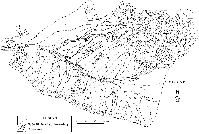
Figure 1: Stream Network Map of Asan River Watershed, Doon Valley, India Interpreted form Landsat TM FCC Image 146-039, Date 19 January 1989.
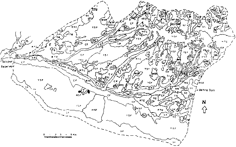
Figure 2: Landuse-cover Map of Asan River Watershed, Doon Valley, India Interpreted form Landsat TM FCC Image 146-039, Dated 19 January 1989.
Table 1
| Fi | Model parameter, FiParameter description | Satellite derived regrouped land use – cover classes in terms of erosion potential |
| F1 F2 F3 F4 F5 |
Area under reserved & protected forest Unclassified forest area Cultivated land Grass & posture land Wasteland |
YSF, MSF, MF SF, SC, HO, TG HTC, RTC, CF UB, OS, FB, B E, SQ, SD |
Table 3
| Sub-watershed | Sediment yield rate ha.m/100 sq.km/year | Priority class for conservation planning |
| H K A, B C, D, E, F, I, J,L G |
> 9.0 6.4 - 9.0 3.8 - 6.4 1.2 – 3.8 <1.2 |
Very High High Medium Low Very low |
Conclusion
Sediment yield model, adopted here, has the advantage of accepting significant physical parameters ALui, Ai, Ddi of watershed derived from satellite data. a schemes for priority class of watersheds is outlines based on these yield data ranges. In absence of measured sediment yield in small watersheds, this method will be immensely useful. for conservation planning proposes. A more global approach would be to build up sufficient data base using the methodology enunciated here to arrive at optimum threshold for prioritization of watersheds.
Acknowledgement
Author is thankful to Prof. B.L. Deekshatulu, Director, NRSA & Prof. S.K.Bhan, Head IIRS for good encouragement to carry out this R&D work and for permission to present the paper in this conference.
References
Bali, Y.P.Karale, R.L.1977. ‘Sediment Yield Index as a Criterion for Choosing Priority Basins’, IAHS-AISH Publication No.122, Paris, P. 180-188.
Kumar, S. 1985, ’Reservoir Sedimentation’ in Proc. Short Term Course on Planning, Design & Operation of Reservoirs. Patna University, India, 8p.
Rao, H.S.S. Mahabaleswara, H.1990. ’Prediction of Rate of Sedimentation of Tungabhadra Reservoir’ Proc. Sym. On Erosion, Sedimentation & Resource Conservation, Dehradun, India, Vol. I, P-12-20.
| Sub watershed | Ai | Li | Ddi | Si | Fci | Pi | Vsi | SYRi |
| A B C D E F G H I J K L M N O P Q R S T U V X Y |
49.355 36.465 7.021 23.165 24.550 12.292 17.010 49.682 21.144 21.171 61.389 61.044 95.421 13.116 22.857 5.320 4.781 4.967 34.106 6.784 4.817 15.649 15.023 7.887 |
137.16 119.74 14.18 64.39 59.09 13.19 12.85 102.53 31.42 32.76 99.66 18.68 111.52 18.84 33.15 8.75 11.50 8.00 50.64 10.37 5.85 31.55 21.32 17.56 |
2,78 3.28 2.01 2.78 2.40 1.07 0.76 2.06 1.48 1.54 1.62 0.30 1.168 1.436 1.450 1.644 2.400 1.610 1.484 1.528 1.210 2.010 1.420 2.220 |
0.157 0.170 0.070 0.130 0.102 0.068 0.030 0.152 0.041 0.027 0.102 0.029 0.039 0.066 0.091 0.043 0.108 0.101 0.075 0.062 0.020 0.053 0.131 0.092 |
0.365 0.341 0.306 0.303 0.292 0.367 0.340 0.593 0.452 0.405 0.548 0.214 0.352 0.408 0.240 0.259 0.250 0.282 0.290 0.243 0.273 0.235 0.219 0.257 |
196.62 194.40 184.72 186.71 184.15 161.26 156.57 146.33 138.51 127.32 144.53 156.63 136.14 153.44 136.65 116.12 116.12 116.12 166.12 126.63 149.89 144.76 148.64 158.64 |
23.0 15.4 0.87 4.957 4.368 1.817 1.717 46.33 5.30 3.475 42.054 10.00 17.62 2.334 1.300 0.182 0.252 0.228 2.754 0.244 0.208 0.868 0.767 0.568 |
4.66 4.22 1.24 2.14 1.78 1.49 1.01 9.34 2.51 1.64 6.85 1.64 1.85 1.78 0.57 0.34 0.53 0.46 0.81 0.36 0.43 0.55 0.51 0.72 |
| 24 | 615.016 |