| GISdevelopment.net ---> AARS ---> ACRS 1991 ---> Poster Session |
Estimation of sea surface
temperature from LANDSAT-5 Satellite data
Mohd Ibrahim Seeni
Mohd,Samsudin Ahmad,Adeli Abdullah
Centre for Remote Sensing, Faculty of Surveying
University Teknologi Malaysia,Locked Bag 791
80990 Johor Bahru, Malaysia
Fax.: (607) – 572555
Centre for Remote Sensing, Faculty of Surveying
University Teknologi Malaysia,Locked Bag 791
80990 Johor Bahru, Malaysia
Fax.: (607) – 572555
AbstractM
Temperature measurements of the sea surface is important in a number of oceanographic applications. This includes applications to determine fish breeding areas, thermal plumes in water, etc. Many studies have been carried out in this area using airborne and space borne platforms. The most frequently used spaceborne data is from the NOAA satellite. In this paper, a method of determining the temperature of the sea surface from the Landuse-5, Thematic Mapper satellite data is described. Some results obtained in the coastal waters of Pulau Tioman, Malaysia from this satellite data are presented.
Introduction
The temperature of sea water is a vital parameter in understanding the role of the ocean as a heat reservoir. Changes in temperature cause variation in the properties of the sea water and the life it supports. The temperature of the sea water can be measured with the standard mercury thermometer from water samples collected from a ship. This method applies only to surface water. With the use of remote sensing techniques, the “skin temperature” ( about 20mm) at the sea-air interface is measured. Normally this makes use of the thermal infrared radiometer operating within the 8-15 mm range which provides the greatest transparency to radiation emitted from the sea surface. The thermal infrared measurement is adversely effected by the presence of water vapour and clouds in the atmosphere. There are large number of satellites equipped with thermal infrared sensors designed for sea surface temperature measurement such as Nimbus , NOAA, TIROS and Meteosat. However , in the paper a method of estimating sea surface temperature from the thermal infrared band of the Landsat-5 Thematic Mapper will be presented.
Principles and Algorithms
The method of estimating the temperature of the sea surface is based on Gubbons et al. ( 1989). The Landsat-5 TM band 6 digital data (10.4 – 12.5mm ) which is located in the thermal infrared region of the electromagnetic spectrum was used. Because the direct solar irradiance at this band location is negligible, thermal temperatures of surface features can be estimated during either day or night passes of the Landsat-5 satellite by conversion of radiance to temperature values. The TM band 6 radiances represent average values over areas of 120 x 120 m, and temperatures derived are thus average temperatures.
Constants relating the digital Numbers (DN) to the effective at-satellite spectral radiance were used in the determination of the temperature. The values for both spectral radiance (Rm) and temperature (tm) derived from the radiances through the block body inversion algorithm are termed “uncorrected” because atmospheric adjustments are not included. These are determined by using equations (1) and (2) Markham and Barker, 1986).
Where Ru = uncorrected spectral radiance in mwcm-2sr-1mm-1, and a and b = 0.005632 mwcm-2sr-1mm-1DN,-1 0.1238 mwcm-2sr-1mm-1 respectively, and
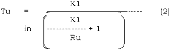
Where Tu= uncorrected temperature in degrees k.
K1 = 60.776 mwcm-2sr-1mm-1 and
K2 = 1260.56 K.
The corrected radiance was calculated by using the equation
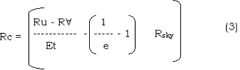
Where e = emissivity of water (0.986), t is atmospheric transmittance, Ra is the path radiance and Rsky is the sky radiance. The atmospheric transmittance t and the path radiance Ra are usually computed by using the LOWTRAN propagation model.
The values for Rsky may be obtained by the empirical Idso-Jackson formula (Wukelic et al., 1987; Suits 1985). Since the details for implementing these calculations were not available, another approach for computing these values approximately were adopted. Ra, Rsky and t were calculated by using the equation of Sturm ( 1981).
The value of Rc was substituated into equation (2) to obtain Tc’ the corrected surface temperature.
Study area and results
The method of obtaining the surface temperature of the water as described in section 2 was implemented on the Landsat-5 band 6 digital data acquired on 1 April 1990 over Pulau Tioman, Malaysia. Although the satellite scene is cloud free over the study area, there were scattered clouds in other parts of the scene.
The band 6 digital values were used to derive the sea surface temperature values through a computer program which was written from this purpose. The average digital numbers at every 20 pixel intervals are shown in Figure 1. The corresponding temperature values are shown in Figure 2.
The digital numbers range from 128 to 135 with the corresponding temperatures ranging from 23° C to 26° c. Since in-situ temperature measurements were not made at the time of satellite temperature measurements were not made at the time of satellite pass, it was not possible to verify the accuracy of the results.
Conclusions
The surface temperature of the water the was obtained over the study area ranged from 23° C to 26° c. These values are generally lower by about 3° C from the normal temperature values over these waters. The inaccuracy in the results is mainly due to the approximations in the algorithms used for computing the atmospheric effects.
References
Gibbons, D.E. Wukelic, G.E. Leighton, J.P., and Doyle, M.J., 1989. Application of Landsat Thematic Mapper Data for Coastal Thermal Plume Analysis at Diablo Canyon. Photogrammetric Engineering and Remote Sensing , Vol. 55, No.6.
Markham, B.L., and Barker, J.L., 1986. Landsat MSS and TM Post-Calibration Dynamic Ranges, Exostmospheric Reflectance’s and At-Satellite Temperature. EOSAT Landsat Technical Notes No.1, August, EOSAT, Lanham, Maryland.
Sturm, B., 1981. Ocean Colour Remote Sensing and Quantitative Retrieval of Surface Chlorophl in Coastal waters using Nimbus CZCZ Data. Oceanography From Space (J.F.R. Gower, ed. ), Plenum Press, New York and Landon.
Suits, G.H., 1985. Natural Resources: The Infrared Handbook. (W.L. Wolfe and G.J. Zissis, eds). Environmental Research Institute of Michigan, Ann Arbor, Michigan.
Wukelic, G.E. Gibbons, D.E. Foote, H.P., and Martucci, L.M., 1987. Landsat Thematic Mapper Radiometric Calibration Study . Third Annual Landsat Workshop, September 1-3. Laboratory fro Terrestrial Physics: National Aeronautics and Space Administration/Goddard Space Flight Centre, Greenbelt, Maryland.