| GISdevelopment.net ---> AARS ---> ACRS 1991 ---> Poster Session 2 |
Evaluation of Coral Systems
through Remote Sensing - A case study in Nicobar Islands, India
M.V.R. Murti, B. Babu
Madhavan, B. Krishna Mohan and G. Venkataraman
Centre of studies in Resources Engineering, IIT, Bombay, India
Centre of studies in Resources Engineering, IIT, Bombay, India
Abstract
Studies on corals of Andaman and Nicobar islands are limited and these deal essentially with coral and reef resources. In the present study image processing techniques have been used on Landsat TM digital data to bring out different coral systems. Discussions are presented on the extent and the feasibility of mapping and monitoring the geomorphological zone of reefs through digital processing of the Landsat - 5 TM data. The classifications made in this investigation are based on color reflectance of submerged features. While it is an accepted fact that water depth affects the color and volume reflectance of submerged features, band 2 of TM is analyzed for submerged / exposed reefs with varying bathymetric elevations and morphological features. But this investigation initiated a digital and comparative techniques for remotely sensed data for submerged reefs. With the aid of bathymetric charts and coastal geomorphology map (derived from topographic maps) probable locations of different coral systems have been delineated based on their extent and evolution stages and are presented as coral maps.
1. Introduction
Coral reefs are a tropical, shallow water ecosystem, largely restricted to the area between the latitudes 30 degree N and 30 degree S. Corals generally have very specific environmental requirement for light temperatures, water clarity, salinity and oxygen. Even in the clearest seas, reef-building corals are restricted to depths of less than 30m and are generally found much shallower (Coral Reefs 1988). The Andaman-Nicobar islands have extensive well developed reefs. All the islands in Andaman and Nicobar have fringing reefs, and their extent away from the shore can be easily obtained form hydrographic/navigational charts (Wafer, 1986). The islands are roughly between 7° N and 8°N.
The present work attempts at locating zones of coral activity through the analysis of remotely sensed data with the aid of bathymetric and thematic maps. Corals encountered, have been categorized into several classes based on their location, evaluation and extent.
On coral reef resources management, studies are now being conducted to determine the extent of useful information derivable from Landsat coral reef images from digital analysis. By using Landsat data, Smith et al. (1978) categorized and mapped the physiographic zones of Australian Great Barrier reef (Cape Melville area) by automated processing of Landsat (ERTS) data and they evaluated them with respect to aerial photographs. Major physiographic zones and bottom cover types of Apo reefs have been categorized and mapped using combinations of unsupervised and supervised modes of digital processing by Ricardo (1978), Significant studies about Indian Coral reefs include Ahmed (1972), Pillai (1983, 1983b) and wafer (1986).
Location
The study are is considered within northern latitudes 7°45' to 8°15' and eastern longitudes 93°25' to 93°40'. Islands belonging to Nicobar district are Camorta in the middle, Trinkat at the eastern part, Nancowry in the southern part and Katchall at the southwestern region (figure 1). These islands are separated from the Andaman groups by Tem-degree-channel 2 which is 135 km wide.
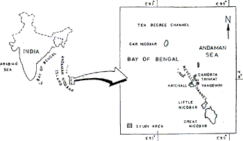
Fig. 1 Index for Study Area
Geology
The rocks composing the islands are fossiliferous marine petroliferous bed conglomerates, sand stone, shale and limestone of Eocene to Pliocene age. Nancowry island bears deposits of serpentine, ophiolite and Radiolarian cherts of upper Cretaceous age and Recent Corals. Katchall island bears deposits like limestone conglomerate and gray wackes of Paleocene to Oligocene age. See Gee (1826) for more further information.
Relief, Topography and Coastal Features
The topographic map studies reveal that the islands show a very indented coast. The general orientation of the structural strike is N-S and the ridges are also N-S. Most of the creeks and inlets or promontories or islets are also running north south. Almost all the islands are marked by a rugged topography and rocky hills and ridges. The general topography of the coastal zone is a markedly sloping, dissected rock but forested ground. It frequently terminates near shore in coral reefs or precipitous cliffs and heavy bay flanked by high rocky slopes.
Remote Sensing Study
Since many coral reef systems are so large and inaccessible, the gross features of their structure and development are difficult to survey on any regular basis. The particular means to monitor all types of reefs have become available only recently with the advent of satellite and aircraft borne multi spectral sensors. With these tools it is possible to conduct thematic surveys of reef more efficient than in any other way. Landsat - 5 TM data in red, near infrared (NIR) and mid-infrared (MIR) in the digital from have *been used for the evaluation of corals. Batheymetric chart for the study area is referred to classify different corals. Due to the voluminous nature of data, the digital image processing methods are more useful. Band differencing was performed on TM bands 2 and 4 on which an edge extraction technique was employed to bring out the land water boundary clearly. This was overlaid on the images as a useful interpretation aid. A coastal geomorphic map is prepared using topographic maps by extracting various coastal land form features (figure 2). Bathymetric chart for the area s used as one of the vital collateral data.
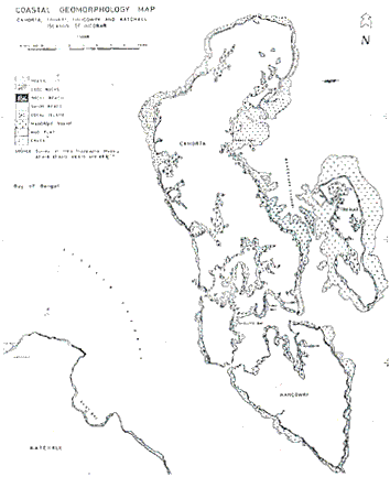
Fig. 2 Coastal Geomorphology Map
Through the use of images derived from digital image processing techniques, satellite and conventional oceanographic data have been integrated synergistically to form a powerful analytical tool for coral studies. On examining the images generated from the above processes, it is found that the density sliced images provide a reflectance contour map which is moderately useful for detecting relative changes or differences in reef structure and water depth. Classified images most resembled a qualitative map of bathymetry. The selection of classes of all the training sets was based solely on apparent differences observed in the images.
Although water penetration may be significant in only two bands (1 and 2) the data were still adequate for effective classification of submerged reefs. However we have attempted to identify, map and inventory the principal zones that are distinguishable in photographs, even though their specific features (eg. coral density) are still undefined. Our intention so far has been to test and demonstrate the digital processing approach to reef locations without reference to any particular requirement or problem like reef monitoring and / oil prospecting.
Selection of the bands of Landsat-5 TM sensor is based on the interaction of certain electromagnetic waves with rocks of those forming shallow shelf zones and those of exposed above sea level, interaction with oceanic water surface and contents. Data from band 2, band 4 and band 7 are being used. Though the wavelength ranges in band 2 and are used to measure vegetation, as the ranges are very close to blue (band 1) information of shallow water features can be expected due to the water penetration capability of electromagnetic waves of 52Um range (Swain and Davis 1978). Band 2 image shows shallow submerged details around the islands rock features in the shelf zone are enhanced in the band 7 image and as most of the shelf zone rock formations bear corals of different species, it is possible to delineate different coral zones.
An attempt to classify different corals based on their spectral features resulted in coral classes based on evolution and their geographical locations. One of the coral system classification maps shows windward, channel reef, bay reef and knolls which are classified based on their geographical location (figure 3). Reddiah's (1972) classification system on corals is considered for our coral classification. By comparing TM band2 classified image with Bahtymetric charts and toposheets, at some places it is found that the following coral class can be possibly delineated.
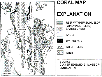
Fig. 3 Coral Classification Map
Windward reefs grow in the direction of prevailing winds on the most exposed shores, and have gradual reef slopes. For example the bathymetric contours 5m, 10m, 11m and 18m run adjacent to the eastern coastal region of Trinkat island and they fall under this windward reefs. Similar Bathymetry is noticed on the north-western part of Camorta island.
Channel reefs line the sheltered shores between islands, as visualized in between camorta and Trinkat islands.
Bay reefs form in similar wind and warm conditions as channel reefs, but are characterized by much heavier sediment loads. In the classified images red color noted in bay in Camorta island may belong to this category.
Knoll reefs are found in the channels, often adjoining the main fringing reef, and rise from the sea floor at about 20m. All the magenta color except some larger isolated clusters is grouped under this class.
Reef flats or platforms are identified by the extent of reefs upto 1 Km from the land. Coastal geomorphology map define these flats which are marked around camorta and trinket islands. Shores in the eastern region of camorta island show reef flats with an extent of 2.5km near parwer point. Trinket islands is mostly surrounded by the reef flats whose width ranges from 2 to 3 Km.
The possible places of occurrence of corals, both dead and alive are located from the classified image (figure 4). In proximity to land are dead coral platforms or coral rocks. Supervised image classification technique using maximum likelihood classification rule applied to the band 2, 3 and 7 images shows some classes which in association with bathymetric chart and toposheet made possible to delineate the occurrence of corals. Corals fringing to land are frequently exposed to sunlight and inundated by seawater at high tides, finally die and form the above said coral rocks. The color code given to this class is gray (figure 4). Further to this dead corals towards seawards are living corals and the color code is white. Due to the limited availability of previous investigations to show the feasibility of mapping and monitoring physiographic zones of coral reef systems through Remote Sensing data or else, it is always difficult to evaluate the accuracy and reliability of coral maps/bottom features maps based on single date coarse resolution data. further it is true for targets where no ground information is available.
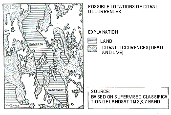
Fig. 4 Possible locations of Coral occurrences
References
- Ahmed. E 1972, Coastal Geomorphology of India. Orient Longman. New Delhi
- Coral Reefs of the world, Vol.2, Indian Ocean, Red Sea, and Gulf IUCN Publication Services, 2196, Huntington Road, Cambridge.
- Gee. E.R.1826, The Geology of Andaman & Nicobar Island. Record, G.S.I., Vol. 59 Pt. II (Calcutta) pp 408-432.
- Pillai, C.S.G. 1983, Stony corals of the seas around India, Pro. Symp. Corals and coral reefs. Mari. Biol. Ass. India. PP 191-216.
- Pillai, C.S.G. 1983b, Coral Reefs their environment. In: Mari culture Potential of Andaman Nicobar Islands- an indicative survey CMFRI Bull. 34:36-43.
- Reddiah, 1972, The Coral Reefs of Andaman and Nicobar Islands. Rec. Zool. Surv. India, pp 315-324.
- Ricardo T.Bina, Kent Carpenter, Wolfgang Zacher Robert Zara and Jose Bernardo Lim, 1978. Thematic mapping of coral reefs using Landsat data. Proc.of 12th Int. Sympo. On Remote Sensing of Environment. Vol 3 pp 585 -593.
- Shepard.F.P., 1963, Submarine Geology. Second Edition, Hapar & Row.
- Smith, V. Elliot, Robert H. Rogers and Larry E. Reed, 1978. Thematic Mapping of coral reefs using Landsat data. proc. of 12th Int. Symp. On Remote Sensing of environment. Vol. 3 pp 585-593.
- Wafer. M.V.M. 1986 Corals Reefs of India. Proc. Indian Acad. Sci. (ani.Sci.Plant Sci.) Suppl. Nov. pp 19-43.