| GISdevelopment.net ---> AARS ---> ACRS 1991 ---> Poster Session |
Application of Remote Sensing
for analysis of urban fringe dynamics – case study of Jaipur, India
B. Ramesh
Indian Institute of Remote sensing, 4 Kalidas Road, Dehradun, India.
N. Krishnan
Madhurai Kamraj University, Madhurai, Tamilnadu. Inida
Indian Institute of Remote sensing, 4 Kalidas Road, Dehradun, India.
N. Krishnan
Madhurai Kamraj University, Madhurai, Tamilnadu. Inida
Abstract
Urban fringe development is resultant of natural increase of population of the city and migration of rural population in search of better living. In the process, some increased population is absorbable in the main city and the rest have to settle in the fringe areas of the city. To monitor fringe area dynamics, Remote Sensing is the best available technique and with it timely information generation is possible. In this paper fringe area development trends have been studied with the help of the aerial photographs and satellite imagery. The total covered study area is in three planning districts (zone) of Jaipur. Maximum development was observed in Jothwara industrial zone.
Introduction
Organized city structure in time frame is going to change its shape due to growth of population. Urban planners/decision makers fix their planning targets’ of growth of city for give time frame but due to lack of monitoring stages of growth and due to pressure of urbanization results in unorganized development in the fringe areas of city. In fringe area development mainly non-urban land transforms into urban land. One of the important reason for fringe development is due to inadequate zoning regulations outside the main city. There is also gap between planned development and population growth which also results into informal development. To check informal development or regularize the informal development and to provide facilities with in the time frame of city structure planners/ decision makers need up-to-data on land use development at regular intervals as per their ‘planning targets’. One of the best method available for collecting dynamic trend of urban development is Remote Sensing. With it timely information generation is possible and spatial growth detection is also possible.
Study Area
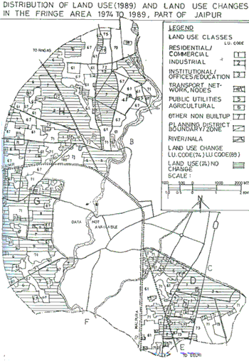
Jaipur city is State Capital of Rajasthan and is the 12th Metropolitan city of the country as per 1981 census. Its population in 1981 was 1.01 millions. Being State capital it provides services to entire state. Its growth rate was observed 6% per annum during 1971-81 decade. The total study area covers in three planning districts namely Gandhinagar (Zone D), Jodhwara (Zone H) and Civil Lines (Zone G).
Objective of Study:
To map the landuse/landcover for different base years in order to analyze urban development trends in the fringe area of Jaipur city during the period between 1974-98.
Limitation and Variables Considered
The present analysis is, however, limited to only major land use classes because of the use of different scale data products as cited below:
- Residential/ Commercial Landuse:
- Industrial (mostly large and medium size units).
- Institutional and educational offices.
- Transport nodes and network.
- Public utilities services – (Cultural, Historical monuments and other utilities like water tanks, power hose etc.).
- Land under cultivation.
- Other built tup lands.
A set of black and white aerial photographs of the year 1974 and colour photographs of 1985 on 1:10,000 scale. SPOT photo data product FCC (Geocoded) of May 1988 on 1:50,000 and August 1988 on 1:100,000 scale. Survey of India Toposhet of the year 1971 on 1:50,000 scale and Tourist Map of 1985 on 1:20,000 scale.
Methodology
To fulfill the objective of the study, the following stages were followed:
1 Prefield : M
After finalization of the study subject, which is also based on the available reports and other collateral materials prefield plan was formulated. Based on the input data as mentioned above, the prefield work carried out as under:
- Preparation of photo index for 1975 and 1985 to find out overlap portion for the study. Preparation of the Base Map on 1:10,000 scale using enlarged Guide Map.
- Photo interpretation was carried out for first one pilot area for better understanding of classification system, then double scanning interpretation was carried out for the whole area of 1975 and 1985. SPOT image interpretation was carried out on 1:50,000 scale and 1:100,000 scale by visual interpretation technique. Detailed landuse classification was aggregated for SPOT interpretation. Interpreted overlays were transferred on to Base Map using Kargal reflecting projector. Sample points were selected overlying grid of 28mm x 28mm on interpreted map, intersection of grid points were marked for field check.
2 Field Work :
After initial reconnaissance survey in the field, detailed field work was carried out for accuracy testing. In second phase, updating was carried out for selected planning districts using SPOT interpretation and field observations.
3 Post Field Work :
Areas were calculated for all base years and final maps were prepared for analysis.
Accuracy :
Accuracy testing was carried out for whole city area (Refer Table. 1.) Interpretation accuracy was checked based on the evidence observed on the ground.
| AERIAL1974 | PHOTOGRAPHS1985 | SPOT1968 | |
| Total No. of Points | 63 | 27 | 81 |
| Points observed Correct | 59 | 24 | 72 |
| Points observed wrong | 4 | 3 | 9 |
| Accuracy % | 94 | 89 | 89 |
Results and discussions
1. Distribution of Major Landuses :
Landuse pattern in selected planning districts were found different functional units. They were classified according to landuse distribution (Table. 2), Gandhinagar classified as institutional zone, Jothwara Planning District into Industrial zone and Civil lines planning district into Residential zone. As per the Landuse distribution, Urban expansion scope was observed in Jothwara and Civil lines planning districts where as Gandhinagar has all most reached to saturation point because of non-availability of non-urban land.
| Land use code | 1 | 2 | 3 | 4 | 5 | 6 | 7 | Total |
| Gandhinagar | 50.5 | 3.0 | 22.8 | 2.8 | 5.9 | 0.0 | 12.0 | 100 |
| Jothwara | 23.5 | 13.4 | 0.01 | 4.7 | 5.7 | 9.1 | 43.5 | 100 |
| Civil Lines | 14.8 | 0.0 | 1.50 | 7.1 | 1.0 | 19.1 | 56.4 | 100 |
In Gandhi Nagar institutional landuse (23%) was observed more because of location of Rajasthan University related educational institutes. It also contains light industries which cover 3% of the area. Due to location of work places and proximity to core city, Residential/ Commercial landuse development was observed. Significantly (51%) of the non-built up land was observed to be mostly (12.1%) attached to institutional areas.
Jothware planning district contains 13% of industrial area which has mostly large and medium industrial establishments. This zone has ample scope for expansion of residential and industrial area because all most half of the total zone area is found to be non-built up mostly vacant land suitable for development.
Civil lines planning District was found basically a residential area. It has non-builtup area of about 56%. During recent years notable development was observed in transport network resulting into rapid landuse change from non-urban to urban.
2 Landuse Development trends in Fringe Area (1974-1989) :
Zonewise landuse Development trends were studied for the base years between 1974 to 1988 and 199. In total study area between 1974-1989 average annual decrease of agricultural lands were about 6% and non builtup was 1.5%. Zone wise landuse growth is given in below Table No. 3. Refer Mapl for change between 1974-1989.
Table: 3 Planning district wise Land Use distribution & Growth 1974-1989. (Area in sq.kms. Figure in bracket are % growth)
Zone D Ghandi Nagar
| lu code. | 1 | 2 | 3 | 4 | 5 | 6 | 7 | Total |
| 1974 | 2.10 | 0.39 | 1.53 | 0.53 | 0.77 | 1.69 | 6.03 | 13.04 |
| 1988 | 5.82 | 0.39 | 2.24 | 0.63 | 0.80 | 0.03 | 3.15 | 13.04 |
| 74-88 | (178.1) | (0.0) | (0.71) | (0.10) | (0.30) | (-1.60) | (-2.28) | - |
| 1989 | 6.57 | 0.39 | 2.96 | 0.75 | 0.77 | 0.03 | 1.57 | 13.04 |
| 88-89 | (12.5) | (0.0) | (32.1) | (19.1) | (-3.75) | (0.0) | (-50.1) | - |
Zone H Jothwara
| lu code.. | 1 | 2 | 3 | 4 | 5 | 6 | 7 | Total |
| 1974 | 1.31 | 1.10 | 0.00 | 0.88 | 1.15 | 10.51 | 12.2 | 27.15 |
| 1988 | 6.44 | 3.30 | 0.00 | 1.15 | 1.41 | 3.28 | 11.62 | 27.15 |
| 74-88 | (391.6) | (200) | (00) | (30.68) | (22.6) | (-68.8) | (-4.75) | - |
| 1989 | 6.44 | 3.60 | 0.18 | 1.27 | 1.53 | 2.46 | 11.74 | 27.15 |
| 88-89 | (00) | (9.1) | (-) | (10.43) | (8.51) | (-25.0) | (1.03) | - |
Zone G Civil Lines
| lu code. | 1 | 2 | 3 | 4 | 5 | 6 | 7 | Total |
| 1974 | 0.29 | 0.00 | 0.00 | 0.58 | 0.02 | 5.07 | 7.11 | 13.07 |
| 1988 | 1.25 | 0.00 | 0.07 | 0.85 | 0.13 | 5.32 | 6.23 | 13.07 |
| 74-88 | (331.0) | (0.0) | (300) | (46.55) | (550) | (-18.54) | (-4.78) | - |
| 1989 | 1.29 | 0.02 | 0.24 | 0.39 | 0.13 | 2.49 | 7.34 | 13.07 |
| 88-89 | (53.6) | ( - ) | (243.9) | (9.41) | (00) | (-39.71) | (8.42) | - |
| 1985 | 0.56 | 0.0 | 0.03 | 0.8 | 0.13 | 5.32 | 6.23 | 13.07 |
In Gandhinagar residential/commercial landuse growth was about 178% for 1974-1989 and 12.5% for 1988-89. Institutional landuse has shown notable growth because of establishment of Rajasthan University and its allied educational institutes. Mainly this change was observed from non-builtup lands. With recent establishment of commercial complex and vegetable market nearby Lal Kothi area of this district will have impact on intensity of development in future.
During same period Jothwar Planning district has shown 391% growth in residential and commercial use and 200% in industrial landuse. Significant negative growth was observed in agriculture area where as rest of the land uses did not show much growth. As per the Master Plan, this district was designed for industrial and high dense residential development. This zone has ample scope for consolidation residential and commercial land use.
In civil lines, Residential and commercial landuse growth was 331% and 54% for two base years. Negative growth was observed for agriculture and non-builtup lands. Basically in this district lands are reserved for development by the Government. Areas opened for development were found to be away from these lands.
3 Factors associated with the pattern of landuse Change :
The resons for above cited pattern of landuse development are too many but urbanization is one of the important factor. However, physical factors for this sort of development are discussed below :
Gandhinagar –Institutional Zone :
Growth of residential development because of proximity to city center as well as growing educational institution and other infrastructure facilities creating good environment for residential area development.
othwara Planning District – Industrial Zone :
Existence of high accessibility by rail, road which attracts industrial development. Industrial development which attracts supporting population not only from the district but also from neighboring areas, is leading to high dense residential development. At presents the residential development was observed along the major roads.
Civil Lines – Residential Zone
Slow development was observed in western part of the district because of long distance from the city center. Due to poor accessibility lands are available at cheaper rate as compared to other planning district resulting spares residential development. As per the existing trend and with recent development of transport network medium dense residential development is expected in this zone, in the near future. In due course, this zone will attract service sector in support to Residential development.
As per the past trends (1974-1979) in the three planning districts same trend of development is expected in the future also if n planning interventions takes place from the development authority.
clusions :
The above study demonstrates the application of combined use of aerial photographs and SPOT imagery for fringe area study. The applicability of generated source of information is vital for planning because it provides clear picture of land availability for future development. With the above spatial development pattern and trend, planners are in a position to formulate norms and policies for future development of the area.
Knowledgements
Authors are thankful to the Director, National Remote Sensing Agency, Hyderabad; Head, IIRS; Head, Human Settlement Analysis Group (IIRS), Dehradun for providing full support for the study. Thanks are also due to JDA. For providing necessary data. Lastly thanks are also due to Shri S.S. Kataria for secretarial assistance.
References
HUSAG (IIRS), Dehradun, 1990 – Landuse/Land cover study of Urban Environment using Remote Sensing Data – Case Study of Jaipur, India. (Unpublished report)
Ian Bracken, 1981 – Urban Planning Methods Research and Policy Analysis. Published by Methuen & co., U.S.A.
Mehra. B.L., 1991 - Urban Development Experience – Lesson from Jaipur. Annual Town And Country Planning Seminar.
Sarup Sing, 1991 - Management of Urban fringe. ITPI Journal, Vol. 9, No. 3 (145).