| GISdevelopment.net ---> AARS ---> ACRS 1991 ---> Poster Session 1 |
Classification strategies for
forest cover mapping of hilly terrain in eastern Himalayas, Sikkim a case
study
S. Sudhakar and S.
Sengupta
Regional Remote Sensing service centre, dept. of space,
IIT campus, Kharagpur - 721 302 India
M.L. Arrawatia
State forest department, forest secretariat,
Gangtok, Sikkim
Regional Remote Sensing service centre, dept. of space,
IIT campus, Kharagpur - 721 302 India
M.L. Arrawatia
State forest department, forest secretariat,
Gangtok, Sikkim
Abstract
The State of Sikkim, a part of Eastern Himalaya has immese forest resource potential which has not been documented in recent times due to number of constraints.
The application of remote sensing techniques for plain/undulating terrain conditions is always easy to understand and it is possible to acquire utmost accuracy. However, the hill terrain conditions are not conducive to achieve considerable classification accuracy in view of various factors including shadow.
In the present investigation, the problem expected and their solutions have been dealt with in detail by generating a case study pertaining o Chungthang area of North District of Sikkim. The change of vegetation types as altitude changes has also been studied by applying indigenously developed Digital Terrain Model on the raw and classified data.
1. Introduction
Forests, the source of renewable energy has been over-exploited due to various pressures despite the recognition of their role for ecological stability and balance. As per the statistical data, the forest resources are dangling at a faster rate than the regeneration by afforestation schemes. In Asian itself, the rate of deforestation is 1.8 m. ha as against the afforestation of only about 0.4 m.ha (Rao 1990). The National Forest policy proposes that the total area under forests in the country be increased steadily to cover at least one-third of the total land area, the proportion aimed at being 560 per cent in hilly area and 20 per cent in the plains.
The satellite remote sensing technology with its synoptic view, repetitive coverage and less cost for generating reliable, upto-date information with more than 90 per cent accuracy, paved the way for frequent utilization of this technology for forest cover mapping in various parts of the world including India ( Madhavan Unni 1990).
The State of Sikkim, a part of the Eastern Himalaya has immense forest resource potential. The existing forest stock has not been properly documented in recent times in view of impending difficulties due to hilly terrain conditions. The State Forest Department of Sikkim in association with RRSSC, Kharagpur, has taken up forest cover mapping of the entire Sikkim using IRS-1A LISS-II data pertaining to Nov. 1988. A part of the scene covering 18x18 sq. km. around Chungthang (Lat. 270 - 40' N and Long. 880 - 35' to 880-45' E ) North District, Sikkim has been taken up as a case study to formulate classification strategies for forest cover mapping. The present discussion highlight the methodology adapted for the classification of forest cover of Sikkim using different strategies to achieve better accuracy. (Location Map. 1).
2. Methodology
- Linearly stretched Standard False Colour Composite (Std. FCC) photo prints on 1:100,000 scale were generated
- Ground truth points were marked on the Std. FCC and care was taken to cover the entire range of tonal, textural variations within the image. Special emphasis has been given to acquire more ground information in the areas where the details of the image area obscure due to shadow.
- After acquiring sufficient ground truth information including
moderate to deep shadow regions of the image under study, non-shadow and
shadow regions were given training areas separately under different
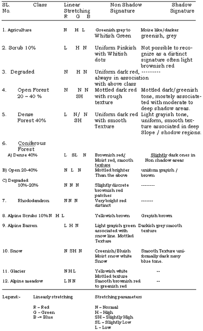
classes. The different stretching parameters adapted for identifying
various classes and their tone/Texture was given in the Table - I.
Supervised classification was done using maximum likelihood algorithm in VAX 11/780 computer environment through VIPS-32 software with 5 per cent threshold to avoid mixing of the classes and to achieve good classification accuracy. - Necessary Digitizer to map, map to image models were generated and subjected the data set for rectification for one to one correspondence with the Survey of India Topographical maps.
- The boundaries of district, lakes, rock outcrops, landslides, habitation, Reserve Forest (RF), National Parks, Wildlife Sanctuary and Biosphere Reserve have been digitized and mask scenes were generated after necessary feature corrections. The mask scenes of district ( Photo.1) and reserve forest were used for extracting the image from the classified scenes. Boundaries of Reserve forest, National parks, Wildlife sanctuary and Biosphere reserve were overlaid on to the classified image.
- After overlaying the lakes, rock outcrops, landslides and habitation area, the reserve forest area was extracted by using RF mask. The agriculture land ( existing as current fallows in the November data under study ) lying within the forest area were modified into Forest Blank. Before compositing with the original scene, the statistical data of different forest classes existing within the RF was also extracted.
- Statistical data of different land use/land cover classes of the entire district including various forest classes of district as a whole were extracted.
- The areas under reserve forest, National part, etc. in each district were computed to plan for afforestation schemes and to evolve an efficient forest management system.
- Indigenously developed Digital Terrain Model software was used to highlight change of vegetation type with altitude.
The photo write products depicting forest density and forest type on 1:100,000 and 1:50,000 scale were generated fore each district.
3. Results and Discussion
The satellite remote sensing technology has already been successfully handled for broad forest resource mapping around the world including India. The real challenge in utilizing this technology for forest cover mapping of hilly terrain in Eastern Himalayas of Sikkim is due to quite a number of constraints like the limited accessibility to the are, high costs associated with ground survey and of little or no existing reliable information about the area and lastly availability of cloud free satellite data (Kawosa 1988).
The ideal classification in delineating various forest density as well as type including other land use/land cover classes for forest management would be one that satisfy the needs of the forest administrative planners with minimum cost, time and upto-date information. The classification of any area would be the ultimate attempt to improve the ability f the planner to understand the existing forest stock and to make reliable statements about the conditions, characteristics, the resource potential and the environmental constraints on the management of forest, if any.
Different classification techniques are now available for use in discriminating various forest and other land use/land cover classes. Among all, the supervised classification using maximum likelihood classifier has been used with considerable success throughout the world (Rogger M. Hoffer 1980).
3.1 Training Computer
The entire success of the classification in supervised classifier depends on training the computer before subjecting the classification algorithm. The training area delineation for hilly terrain is considered very much different from those pertaining to plain terrain conditions. In hilly terrain, each class has to be assigned twice, once in shadow and the other in no shadow areas. Various stretching parameters adapted for identifying different classes that are existing in shadow and non-shadow part of the scene are given in Table 1. This approach has to be followed because shadow regions are darker in tone than the areas facing the sun which are lighter in tone.
3.2 Forest Cover Mapping
In the present investigation, the forests have been segregated to generate two maps: 1. Forest cover map based on its crown cover density; 2. Forest type map based on species composition with respect to climate and altitudinal changes.
Under the Forest Cover Map, the forests are delineated into (a) Dense (Closed) forest > 40% (b) Open forests 20-40% (C) Degraded forest 10-20% (b) Scubs <10% and (f) Forest Blanks.
3.3 Vegetation Types
The flora of Sikkim Himalayas has been carried out by a famous Botanist Shri J.D. Hooker as early as 1848 and all data were incorporated in his Flora of British India published in 1872-1897. Since then, the Botanical Survey of India has been exploring the approachable pockets in parts of Sikkim from Botanical point of view (Rolla S. Rao 1963). However, no comprehensive vegetation type map of the entire Sikkim could not be generated due to the aforesaid constraints.
The synoptic view and multispectral mode of data received from satellite remote sensing could be of immense help in generating vegetation type map of the Sikkim due to the distinct signatures of the species composition with change in altitude. In the present study six broad vegetation types have been demarcated as : 1. Tropical Moist deciduous to Evergreen Forests (300-900 m); 2. Sub-tropical Moist to Semi - evergreen Forest (900- 1800 m) (Wet Hill Forests); 3 - Sub temperate to Temperate to Sub-alpine Forests (1800-2700 m); 4. Temperate to Sub-alpine Forests (2700-300 m); 5. Sub-alpine Forests (3000-3700 m) and 6. Alpine Moorland Forests (3700-4500 m).
3.3.1 Tropical Moist Deciduous to evergreen forests (ALT. 300-900 M)
The Tropical Moist Deciduous to Evergreen Forests with Sal as a member of the association along with a few deciduous components, is the climax type of vegetation in the foot hills of Sikkim. These forests have suffered greatly due to the effect of physiographic, edaphically and biotic factors operating in the region.
3.3.2 Sub-Tropical Moise to semi evergreen forests (ALT. 900-1800M)
As altitude changes from 900-1800 m, the forests are also gradually changes from Tropical to Sub-tropical moist to semi-evergreen forests comprising tree species of Macaranga, Scheima, Eugenia, Sapium, Castanopsis and these are generally mixed with shrubby species of Baliospermum, Clerodendrum and Emblica. It is not normally possible to identify these two vegetation types as separate classes in satellite imagery since the signatures of these mixed composition of species are not distinct.
3.3.3 Temperate Forest (ALT. 1800-2700 M)
The vegetation gradually changes from sub-tropical to sub-temperate in the altitudinal range of 1800-2400 m and afterwards the vegetation becomes distinct Temperate forests.
Terrace cultivation of Triticum (wheat), Hordem (barley), Solanum (potato) and Capsicum (chillies) has found along the tracts in these altitude zones near the villages especially from Chungthang towards Lachung of North District, Sikkim.
In the region from 1800-2400 m, the vegetation components gradually changes to species of Suaga (hamlock), Acer, Michelia, Juglans, Rhododendron, Ilex associated with Rosa, Rubus, Berberis and Viburnum. The typical temperate forests comprising tree species of Quercus (0ak), Acer, Populus, Larix and Abies densa are predominating in the region between 2400 m and 2700 m.
The differentiation of temperate forests from tropical to sub-tropical forest has been found to be easy due to its distinct spectral signatures. However, the transitional stage in the altitudinal range of 1800-2700 m, needs special emphasis before assigning training areas due to mixed association of coniferous species with broad leaf.
3.3.4 Temperate to sub-alpine forests ( ALT. 2700-3000 M)
This range altitude is again considered to be a transitional zone where tall trees of Abies densa are mostly associated with shrubby and busy species of Rhododendron, Juniperous, Berberies and Salix.
3.3.5 Sub-alpine forests ( ALT. 3000 - 2700 M)
The vegetation from typical temperate type gradually changes to subalpine type at higher elevations. The tree species of Rhododendron are predominantly mixed with a variety of species like Gaultheria, Euonymus, vibrunum, Juniperous and rubus.
3.3.6. Alpine forests ( ALT. 3700 - 4500 M )
The vegetation along these elevation and above 4400 m comprises of typical alpine meadows/moorland type where tree growth is completely arrested. Quite a few stunted bushy growth species of Rhododendron are mixed with tough clumps of Juniperous, Salix, Berberis, Rosa and Lonicera are common.
3.4 Anticipated problems and solving
It has been found that the Agricultural areas ( Current fallows in November scene ) and the forest blanks within the Reserve Forest areas have similar spectral signatures, hence there is every possibility of mixing up of these classes. Therefore, it has been suggested to extract the Reserve Forest area by masking. The agricultural lands are to be converted as Forest Blanks and reunite with the original scene by compositing.
Most of the rock outcrops, lakes and built-up areas have been observed in the shadow area and are difficult to segregate due to overlapping signatures with other land use classes. In view of these problems, it has been decided to digitize these features after extracting them from the survey of India topographical maps.
The problem of shadow effect has been successfully solved by assigning different classes of each category in the shadow as well as non-shadow areas. The major problem of moderate to deep shadows have also been solved by boosting its digital range of each training area by acquiring adjacent class digital numbers keeping the spectral range of each of such training sets different. This approach has been worked out to the satisfaction with least overlapping in adjacent forest density classes. However, the implication of such technique has to be thoroughly studied with sound statistical data base before ascertaining the feasibility of utilization for larger areas.
It has also been noticed that the identification of different forest type classes / density classes needs thorough understanding in the field as well as with the image signatures. After keen observation of certain known areas of different forest categories, it has been suggested that the image has to be stretched differently to locate/identify the features correctly. For easy identification of various classes the stretching parameters of Red, Green and Blue filters as indicated in Table I are used after zooming the image four time (4X).
3.5 Digital terrain model
The vital information of elevation, aspect, slope of a particular area, along with the multispectral data could be of immense help in understanding the vegetation changes as altitude varies. In the present study a visual effect of altitude on the vegetation type has been noted by wrapping the raw and classified data on the digital elevation model ( Photo 2 & 3). This shows a spatial distribution of various categories of forest types like Mixed broad - leaf - Temperate - Alpine - Snow line to Alpine meadows at various height zones.
4. Conclusion
The recent development of digital Terrain Models and generation of stereoscopic space imageries highlighted the utilization of Space technology for various applications including forest cover mapping. The importance of microwave remote sensing technology especially in areas like Sikkim where availability of cloud free data is remote, has already been noted and efforts are on the made use of the data from ERS-1.
5. Acknowledgements
The authors are thankful to Shri S. Gunasekaran, Dr. J. Roy and Miss V. Jayasree for their help during the course of the study. They are also grateful to Shri Y. Rajoo, Shir Y.K. Srivastava, Shri M.B. Rana and Shri K. Ranganatha for their secretarial assistance.
Reference
- Champion H.G. & Seth S. K. 1968. A revised survey of the Forest types of India, Delhi.
- Hooker J.D. 1972-97. Flora of British India, London.
- Kawosa M.A. 1988. Remote Sensing of the Himalaya. Natraj Publications, Dehra Dun.
- Madhavan Unni. N.V. 1990. Space and Forest Management in India. Special Current Event Session. International Astronautically Federation 41st IAF Congress, Dresden Germany, pp. 49 - 69.
- Rao. U.R. 1990. Space Technology and Forest Management Specific relevance to Development Nations. Special Current Event Session. International Astronautically Federation 41st IAF Congress Dresden, Germany. PP. 1. - 10.
- Rogger M. Hoffer. 1980. Computer aided analyses techniques for mapping each surface features. Proceedings of Remote Sensing application in Agriculture and Hydrology, Italy.
- Rolla S. Rao. 1963. A Botanical tour in the Sikkim State, Eastern Himalayas, Bull Bot. Survey of India f5(2): 165 - 205.