| GISdevelopment.net ---> AARS ---> ACRS 1991 ---> Poster Session 1 |
DTM extraction and its
application using a digital stereoscopic image processing system with 3d
display
Nobuhiko Mori
NEC Corporation
Teruyoshi Tagawa
Earth Resources Satellite Data Analysis Center
Shunji Murai
University of Tokyo
Saburo Ito
NEC Aerospace Systems Ltd.
NEC Crop (Ground System, Space)
Ikebe-cho 4035, Midori-ku, Yokohama, 226 Japan
NEC Corporation
Teruyoshi Tagawa
Earth Resources Satellite Data Analysis Center
Shunji Murai
University of Tokyo
Saburo Ito
NEC Aerospace Systems Ltd.
NEC Crop (Ground System, Space)
Ikebe-cho 4035, Midori-ku, Yokohama, 226 Japan
Abstract
A new method for the extraction of earth resource information from images and maps has been developed. In this method, newly developed digital stereoscopic image processing system with liquid crystal shutter glasses is used. As this system is composed of a personal computer and its general peripherals, the cost is very low. Using this system, high accuracy DTM can be extracted from the stereoscopic images because the results of computer processing can be easily checked and corrected by using the 3D display of the system. Using the DTM, stereoscopic images for maps of any B/H ratio can be made from a single image or map and they can be used effectively for the extraction of earth resource information especially in the case of that many kinds of stereoscopic images and maps are overlaid on the display.
Introduction
A new Remote Sensing satellite JERS-1 (Japanese Earth Resources Satellite-1), with a stereo imaging system, will be launched in 1992 in Japan. The stereoscopic images and other images of his satellite are expected to be used in a field of mineral or oil resource exploration. Some researchers on these images have been already been conducted and here, a new kind of image analysis method has been developed. The outline of this method is explained in his paper. This method uses a newly developed digital stereoscopic image processing system with 3D display. Firstly, DTM is extracted from JERS-1 stereoscopic images or others by using this system. Secondly, stereoscopic images/maps of any B/H ratio are generated from the interested images/maps using this DTM. At last these stereoscopic images/maps are overlaid to get useful information about earth resources. Since much more information can be extracted from stereoscopic images than from a single image, this method has powerful abilities to extract earth resource information from images and maps.
Development of a digital stereoscopic image processing system
A new type of digital stereoscopic image processing system has been developed. The over-view of this system is shown in Photo 1. The features of this system are explained as follows :
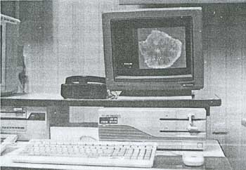
Photo 1. Over-view of the stereoscopic image processing system
- The system has a 3D display module with liquid crystal shutter glasses.
- The 3D display module can display stereoscopic images in frame memories together with stereoscopic drawings in VRAM (Video Random Access Memory)
- Large size displays for general purpose can be used in this system.
- The total cost of this system is lower, about a million US Dollars, because this system is composed of a personal computer and its general peripherals.
It is difficult and expensive to extract DTM from contour lines in large scale maps. Moreover, a large scale map does not always exist especially in mountainous areas. There are new methods to extract DTM automatically from stereoscopic images using general purpose computers. But these methods have some problems, such as the results often contain large errors and these is no method to find out these errors. In order to extract high accuracy DTM easily and automatically from stereoscopic images, a new method is being developed by using stereoscopic image processing system, which is now almost finished. Figure 1 shows the method. The main features of the method are as follows :
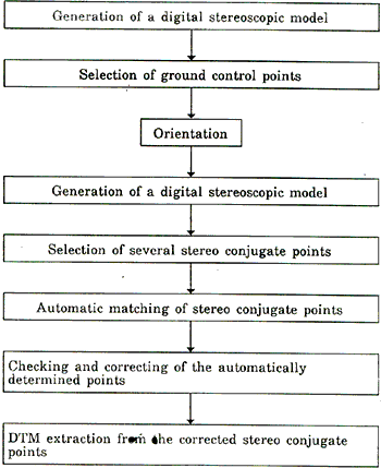
Figure 1 : DTM Extraction method form stereoscopic images
- The most part of the work to extract DTM from stereoscopic images is executed automatically by a computer.
- The results of computer processing can be checked and corrected using stereoscopic image processing system is order to get accurate final results.
- Positions of ground control points in stereoscopic images can be determined exactly owing to the ability of the system to show stereoscopic models on the display.
An experiment of lineament extraction from stereoscopic images of several B/H ratio was performed, and some results were obtained as follows :
- Much more lineaments can be extracted from stereoscopic images than from a single image.
- The most suitable B/H ratio for lineament extraction is different according to the steepness of the area.
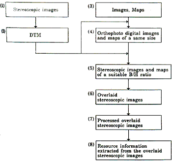
Figure 2 : A method for extraction of resource information from images and maps
- Stereoscopic images which will be taken from JERS-1, SPOT or any other platforms can be used.
- DTM is extracted from stereoscopic images using the method which is explained above.
- Many kinds of images of JERS-1 or other satellites and various maps can be used.
- Images are transformed to orthophoto images using DTM, and maps are transformed to the same size maps with images using affine transformation method.
- Stereo-mates of orthophoto images / maps are made with the most suitable B/H ratio at the study area using DTM.
- Some of the stereoscopic images/maps are written in memory planes of each color and overlaid on the display.
- The Overlaid stereoscopic images on the display are processed using image processing programs in order to enhance useful features
- Useful information about earth resource exploration are extracted from overlaid stereoscopic images.
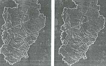
Photo 2. Overlaid stereoscopic images (B/H=0.3)
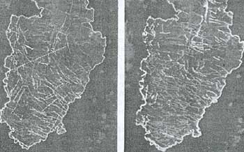
Photo 3. Overlaid stereoscopic images (B/H=0.5)
- Veins, hot springs and lineaments are written in the red planes of image memories.
- JERS-1 imitation stereoscopic images which are made from a LFC photograph are written in the green planes.
- Faults are written in the green planes.
Conclusion
A new method for extraction of resource information from images and maps has been developed. Using this method, many images and maps can be overlaid and displayed on a display as stereoscopic images of any B/H ratio. These overlaid stereoscopic images are very useful for extraction of lineament and other resource information. A new type of digital stereoscopic image processing system with liquid crystal shutter glasses has been developed as the hardware system of owing to the utilization of personal computer. Generating DTM is essential to this method, and a largepart of DTM extraction method from stereoscopic images using this system has been developed. High accuracy DTM can be extracted by this method because the results of computer processing can be stereoscopic images have been made from images/maps and the usefulness of this method has been shown. Such overlaid stereoscopic images as there can be made at anyplace independent to the existence of a topographic map.
Reference
- Mori, Murai, Kawakami, Segawa, Ito : A Personal computer System for Processing of Digital Stereoscopic Imagery; The tenth Asian conference on Remote Sensing, Malaysia, Nov. 23-29, 1989, pp. Q-6-1 ~ Q-6-6
- Mori, Murai, Kawakami, Segama, Ito : PC-based Three Dimensional Measurement System Using Liquid Crystal Shutter Glasses; ISPRS Com. Iv Tsukuba Sympo, May 15-18, 1990, PP. 414 ~ 421
- Mori, Takota, Tonoike, Komai, Murai ; Investigation of the Effectiveness and Applications of Japanese ERS-1 Stereoscopic Images ;ISPRS Kyoto, Japan July 1~10, 1988, Vol 27, Com.1, PP. 109~119.
- Mori, Murai, Bai Ito ; Development of a New Method Attaching Precise topographic Information to GIs by Using 3D Display ; the 11th Asian Conference on Remote Sensing, china, Nov. 15-21, 1990, pp. H-2-4-1 ~ H-2-4-6