| GISdevelopment.net ---> AARS ---> ACRS 1991 ---> Poster Session 1 |
Using Geographic Information
System for agricultural planning in Thailand
Supan Karnchanasutham and
Virchan amarakul
Remote Sensing Center for Agricultural Resources
Office of Agricultural Economics
Ministry of Agriculture and Cooperatives
Chatuchak, Bangkok 10900, Thailand
Remote Sensing Center for Agricultural Resources
Office of Agricultural Economics
Ministry of Agriculture and Cooperatives
Chatuchak, Bangkok 10900, Thailand
Abstract
Remote Sensing center for Agricultural Resources (RCAR) has been using Remote Sensing techniques to gather timely data on crop production and using Geographic Information System (GIS) for Agricultural planning. Ministry of Agriculture and Cooperatives for the many facets of agriculture and relate activities such as forestry, fisheries and irrigation. As part of the plan preparations, the suitability of the soils for each specified crop, hydrology and other environmental factors in each province are assessed in GIS.
Data for this assessment includes :
- Soil suitability map and land map (Land Development Department)
- Conservation forest area and legal forest area (Royal Forestry Department)
- Land cover map (classified form satellite data) by RCAR.
Introduction
Thailand is a richly endowed tropical country with a wide variety of environmental conditions. It has enjoyed a food surplus for many years and is the biggest exporter of rice in the world. Recently, Thailand also has exported foods such as tapioca, canned pineapple and processed seafoods, especially shrimp. Thailand's agriculture has changed dramatically in the past two decades, mainly in response to the "green revolution". The advances associated with this revolution were rapidly accepted in Thailand, as they were in most tropical countries, but with them came increased dependence on artificial fertilizers, pesticides and mechanization.
Thailand's agriculture is closely linked to global markets with more corporate investment, larger holdings and greater dependence on international trade and prices. Both producer and the government require rapid access to accurate agricultural information to monitor the volume of expected harvests, to plan changes in crop production (such as irrigation), and to alleviate environmental problems such as crop diseases and insect infestations.
Accurately, timely and reliable information is necessary for agricultural policy making and planning. To derive such information satellite data analysis and geographic information system (GIS) are being studies and used.
Objectives
- To classified existing natural resources and agricultural resources.
- To use the results of geographic information system to development and planning natural resources and environment.
- Integrated the results of the analysis satellite data and geographic information system.
Chonburi province was selected as a study area which is located along the Eastern coast zone of the gulf of Thailand. It covers a total area of 4,363 square kilometers.
Equipment and Accessories
- Landsat - 5 computer compatible tape taken on November 15th, 1990 Path No.129, Row No. 51 and January 26th, 1991 Path No. 128, Row No. 51.
- Topographic map scale 1:50,000 and 1:250,000
- Land suitability maps for paddy, sugarcane, pine apple, cassava and fruit tree at scale 1:100,000
- Soil map and land unit map scale 1:100,000
- Conservation and production forest and map scale 1:250,000
- Administrative boundary map scale 1:250,000
- Highway map scale 1:50,000
- Computer micro VAX 11 and GEMSTONE workstation.
- Image processing software : GEMSTONE
- Geographic information system : SPANS
Landsat -5, thematic mapper (TM), digital data taken on November 15, 1990 Path No. 129 Row No 51 and January 26, 1991 Path No. 128 Row No. 51 analysed by using GEMSTONE software on the GEMSTONE workstation and micro VAX II (host computer). Maximum likelihood classification was uses for present land use classification. Preparation of provincial agricultural development plans is based to a large extent on soils data prepared by the department of Land Development. A total of 75 soils series have been recognized and mapped in Thailand. These have been generalized into 144 land units as a first step in plan preparation. Even this simple step was a major undertaking before the introduction of GIS techniques. The definition of land units and preparation of soils suitability maps is achieved in SPANS by linking the mapping polygons with an attribute database containing information on factors such as pH, slope, textures and internal drainage.
Other important environmental factors, including the conservation status of watershed, both actual and legal forest status, the location of fish ponds and shrimp farms, and data such as administrative boundaries, are imported into SPANS and properly georeferenced in preparation for analysis using criteria.
Results
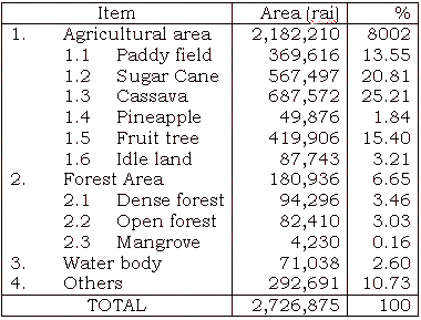
Agricultural Resources classification
Geographic Information System
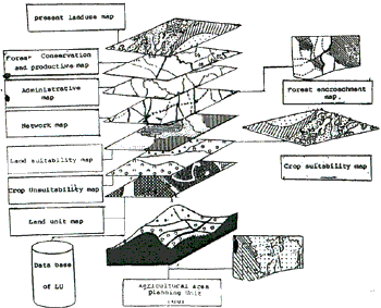
Geographic Information System for Agricultural Development and planning
References
- Aronoff, Stan, Geographic Information System : A Management Perspective, Ottawa, WDL Publications, 1989.
- Burrough, P.A, Principles of Geographical information Systems for Land Resource Assessment, New York, Clarendon Press, 1986.
- Lillesand, T.M, and Kiefer R.w, Remote Sensing and image interpretation, John Willey and Sons, 1979.
- Schowengert, R.A Techniques for Image Processing and classification, in Remote Sensing, Academic Pres, 1983.
- Swain, P.H. and Davis, S.M. Remote Sensing : The quantitative Approach, Mc. Graw Hill, 1978.
- Van der Zee, D., An Introduction to Geographic Information systems, international Institute for Aero scope Survey and Earth Sciences, 1985.
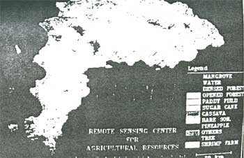
Figure 1 Agricultural resources map in Chonburi province
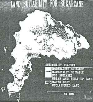
Figure 2 Land suitability for cassava
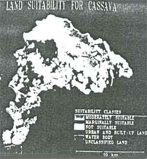
Figure 3 Land suitability for sugarcane

Figure 4 Land suitability for pineapple
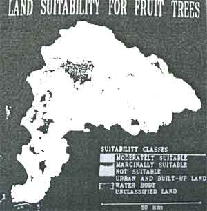
Figure 5 Land suitability for fruit trees

Figure 6 Land suitability for paddy field
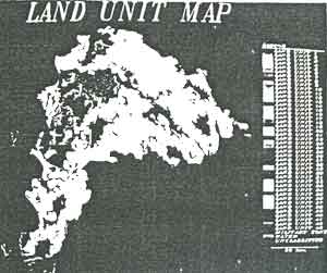
Figure 7 Land unit map of Chonburi province