| GISdevelopment.net ---> AARS ---> ACRS 1991 ---> Poster Session 1 |
An Aerial Photography - Aided
Seaweed Bed Survey Techniques
Yoshio Matsumoto, Eiji
Yamauchi, and Koji Kamihashi
Asia Air Survey Co., Ltd.
Asia Air Survey Co., Ltd.
Abstract
The used aerial photography in seaweed bed distribution surveys has become widespread in recent years. One of the advantages of the use of aerial photography in surveys is that it allows for a wick, economical appreciation in surveys is that it allows for a quick, economical appreciation of the distribution of seaweed beds extending over a wide area.
In the following, we shall introduce the analytical photographic techniques we use in compiling seaweed bed distribution charts classified according to seaweed bed type based on aerial photographs.
Introduction
Seaweed beds play an important role in the reproduction of marine resources; the benthic marine algae they are made up of are themselves an important natural resource, and moreover they function as nursery grounds and habitats for fish larvae of shellfish.
These important functions of seaweed beds are influenced by the type, distribution density, and distribution acreage of the benthic marine algae that make up the seaweed beds, so it is of utmost importance to gain and understanding of these factors through seaweed bed surveys.
In conventional seaweed bed surveys, the methods of observation through a glass box from a boat and direct observation by labor and time when a vast sea areas is to be surveyed. To overcome these difficulties, the utilization of vertical color aerial photography has become more and more prevalent.
Today, we apply the following three techniques for photographic analysis in compiling seaweed bed distribution charts from vertical color aerial photographs :
- Reading photo by eye :
- Digital image processing
- Analog image processing (masking method)
Overview of Seaweed Bed Distribution Survey Process
Figure 1 is a general flowchart of the process of performing a seaweed bed distribution survey with the aid of vertical color aerial photographs.
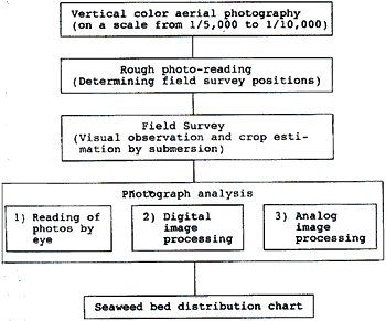
Figure 1 General Flow chart of seaweed bed distribution survey process
Although some amount of field surveying is indispensable in order to determine the types and densities of seaweed beds, no matter which photo analytic technique is applied, rough photo reading can lessen the workload to a level much lower than is necessary with field surveys alone.
Photo analytic techniques and their features
Reading photos by eye
The technique of reading photographs through a mirror-type stereoscopic or directly by eye is applied to the classification of seaweed beds according to photo reading keys.
There are three types of photo reading keys; "tone", "texture," and "Pattern" seaweed bed in the light of established correspondences between photographs and field survey results, as in the keys listed in Table 1:
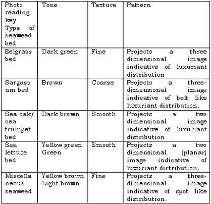
This technique is the most widely used method now a days because it required no special apparatus or equipment. Yet, it presupposes that the photo reader has expertise and can avoid making arbitrary subjective judgement.
Digital image processing
In this technique, digital image data covering the three band (blue, green and red) of positive color film is created and then the image is processed. Figure 2 shows the processing process.
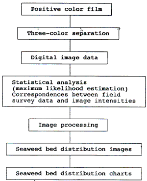
Figure 2 Digital image processing
Maximum likelihood estimation is used for seaweed bed classification.
This technique is capable of giving a fairly objective classification of seaweed beds, yet is disadvantageous in terms of processing costs.
Analog image processing (masking) method
In this technique, images of seaweed distribution zones are directly printed onto films by a photographic processing technique that takes advantage of the blue, green, and red photographic intensity characteristics of positive color films. The basic seaweed bed classification principles are the same as those used in digital image processing.
Figure 3 shows the processing process.
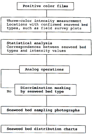
Figure 3 Analog image processing
This technique enables us to obtain seaweed bed distribution charts equivalent to or better than those obtained by the digital image processing technique in terms of precision and quality at a relatively low cost. For this reason, this technique is expected to find much wide application in the future.
Summary
Table 2 lists a comparison of the different photo-analytic techniques.
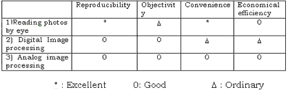
The digital and analog image processing techniques are more objective than reading photos by eye, yet they may have some difficulty in discriminating between types of seaweed bed, depending on the pertinent photographic conditions a sea area conditions, in so far as the currently available classification methods are done only according to tone. To resolve this difficulty, it is necessary to develop techniques for the quantification of the texture and pattern photo reading keys used in reading photos by eye.
In view of these conditions, our view is that under the present circumstances it is most appropriate to use the method of reading photos by eye together with either analog or digital image processing.