| GISdevelopment.net ---> AARS ---> ACRS 1991 ---> Poster Session |
Orthogonal projection mapping
of thematic images for Natural Disaster base map
Takahisa Yamauchi, Dr.
Taichi Oshima
College of Engineering, Hosei University
Kajino-cho, Koganei-si, Tokyo 184, Japan
Dr. Atsushi Rikimaru
Air-Graph Corporation
1749-1 Kamiigusa Kawshima-cho, Saitama 350-01, Japan
College of Engineering, Hosei University
Kajino-cho, Koganei-si, Tokyo 184, Japan
Dr. Atsushi Rikimaru
Air-Graph Corporation
1749-1 Kamiigusa Kawshima-cho, Saitama 350-01, Japan
Abstract
This paper describes system development for investigation of natural disaster, using thematic photo images and digital mapping data (DMD) including ground altitude value. This system configuration is composed of four parts, there are as follows ;
- Preparation of DMD
- Exterior and inner orientation
- Generating Digital Orthogonal photo images by Resampling
- Overlaying DMD and orthogonal photo image
Introduction
In case of natural disaster, many kinds of photo images are observed and collected. These images are not always vertical aerial photographs. Almost photographs are taken for ground investigation or the press. But these photographs are not taken in standardized conditions. Therefore, it is difficult to connect reciprocal informations. The objective of this paper is to accumulate informations and link these images on base map. This study aims to develop the methodology and procedures on how to match there images on base map.
Methodology of Orthogonal Mapping for Natural Disaster
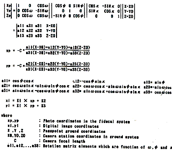
In this study, the orthogonal mapping is carried out from the lique photographs. The orientation of photographs is not easy to use ground control points. Because the photographs are taken from different conditions, and it is difficult to set the ground control points on disaster district. For these reasons, the DMD aided orientation method is carried out for orthogonal mapping. It is the method of exterior and inner orientation of single photo image. The advantage point of this technique is using ground control lines which are drawn from vector data of DMD. The steps for orthogonal mapping are as follows. Firstly, the digitized thematic images are displayed on CRT. Secondly, the digital mapping data is superimposed on the thematic image. The digital mapping data is distorted by exterior orientation parameters. The exterior orientation parameters are obtained interactively. Finally, the orthophoto is generated using these orientation parameters. The orientation method uses the 3- axis rotation matrix equations as follows :
Implementation
The system configuration of this study are composed of four parts below :
- Preprocess
Preparation of DMD, A/D conversion of aerial photo
- Exterior and inner orientation
Operation transforming the photo images into DMD
- Generating digital orthophoto images
Resampling and production of digital orthophoto images
- Overlaying DMD and orthophoto images.
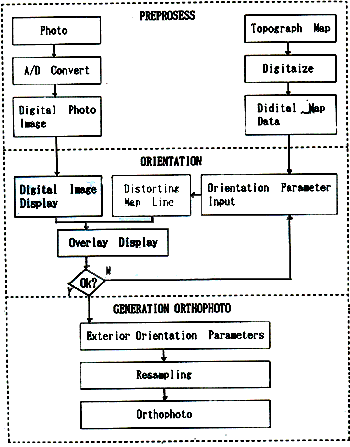
Fig. 1 Flow chart of orientation system
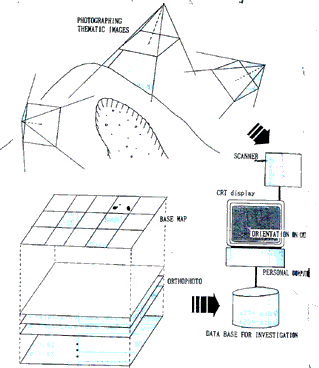
Fig. 2 Outline of orthogonal mapping
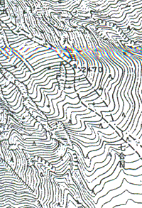
Fig. 3 Topographical map of Ontake
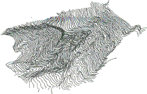
Fig. 4 Bird's eye view of digital contour map
Conclusion
It was noticed that the system, developed in this paper provides effective use of various kinds of photo images as linking each images on the base maps. And it was confirm that the possibility of regulate for standardized information for investigation of natural disaster. In future, it will be able to make the hazard maps of accumulate information on GIS, using this system. The accuracy of ortho photo images have checked in case of vertical photograph for aerial photogrammetory (reference 3). The subject is the development of the system of accuracy check for single and oblique photo images which is able to carry out one after by easy operation.
References
- A Rikimaru, T. Oshima, T.Ikeda, (1989), “development of interactive orientation system of oblique digital image”, proceedings of 1989 symposium, JSPRS.
- A Riki maru, M. Konishi, T. Yamauchi, T. Oshima (1990), “Interactive overlay system of digital mapping data and digitized aerial image”
- A Rikimaru, M. Konishi, T.Oshima (1989), “Extract method of high accuracy control point of geometric correction from center of gravity in closed area”. Photogrpammetry and Remote Sensing, Vol. 28, No. 2, JSPRS.
- JSPRS Analytical photogrammetry committee, (1988), “Analytical Photogrammetry” JSPRS