| GISdevelopment.net ---> AARS ---> ACRS 1991 ---> Poster Session 1 |
Correction of solar Zenith
Angle effect of NOAA AVHRR data for Global Monitoring
Koji Kajiwara, Ryutaro
Tateishi
Remote Sensing and Image Research Center, Chiba University
1-33 Yayoi-cho, Chiba 260, Japan
Masao Mastumoto
Faculty Information Science and System Engineering
Kyushu Institute of Technology
680-4 Kawazu Iizuku, Fukuoka 820, Japan
Remote Sensing and Image Research Center, Chiba University
1-33 Yayoi-cho, Chiba 260, Japan
Masao Mastumoto
Faculty Information Science and System Engineering
Kyushu Institute of Technology
680-4 Kawazu Iizuku, Fukuoka 820, Japan
Abstract
Normalized Different Vegetation Index (NDVI) in Global Vegetation Index (GVI) products of AVHRR which provided by NOAA has been widely used for the research of global or continental scale land cover monitoring. Through NDVI was designed to eliminate the change of solar illumination, it is still not completely free from radiometric effects. In this paper, results of the simulation done by using radiative transfer calculation software package LOWTRAN-7 to evaluate the effects of solar zenith angle of the AVHRR Ch. 1 and Ch 2 data, and the factor of temporal variation of solar zenith angle are described. A correction method to remove the effect of low frequency temporal variation of solar zenith angle is also proposed.
Introduction
As some researchers has been pointed out, NDVI values derived from AVHRR data in GVI Product provided by National Oceanic and Atmospheric Administration (NOAA) are affected by solar zenith angle (Singh 1988, Matsumoto et al 1991). The long term global and cover monitoring which uses NDVI should be considered the effect of solar zenith angle especially effect of low frequency variation of solar zenith angle (describe in section 3). This paper aims to clarify the characteristics of the effect of solar zenith angle and to propose a correction method for AVHRR Ch. 1 and Ch. 1 data. In section 3, the characteristics of the radiometric effect by solar zenith angle is clarified by simulation. And the factor which cause the variation of solar zenith angle discussed in section 4. Finally, by the section 5, AVHRR channel data correction method for long-term global monitoring is proposed.
Second generation GVI production
The second generation GVI products started in April 9, 1985 when AVHRR data of NOAA-9 became to be available. And from November 7, 1988, they were produced from NOAA-11 AVHRR data. The data used in this study is weekly Plate Carree GVI which is one of the second generation products and include NDVI, Ch.1, Ch. 2, Ch. 4, Ch. 5 scan angle and solar zenith angle. The weekly GVI data cover from 75°N latitude to 55°S latitude on Plate Carree (latitude/longitude) projection by 2500 x 904 pixels. Since July 9, 1990, a calibrated NDVI (CVI) has been added into the products (Kidwell 1990).
Radiometric efect by solar zenth angle
A simulation of radiate transfer was carried out by using software package LOWTRAN-7 estimate radiometric effect by solar zenith angle in Ch. 1 and Ch.2 wavelength regions. In this study tropical and sub-arctic winter model were selected as atmospheric models to demonstrate dry atmosphere and wet atmosphere respectively. Each standard atmospheric models of LOWTRAN-7 has an assumption about the quantity of contained water vapour in atmosphere. These assumption are, in precipitable water 4.13 cm for tropical model (wet atmosphere) and 0.41cm for sub-arctic winter model (dry atmosphere). In these atmospheric models, outgoing radiance to AVHRR sensor was calculated for various surface albedo (reflectance) values and solar zenith angles. On these conditions, surface albedo varies form 0% of 60% with 5% interval, and solar zenith angle varied from 0° to 90° with 5° interval. Then, calculated radiance for each condition were converted to percent albedo.
By figure 1 is the result of simulation for surface albedo values 5%, 20%, 40% and 60% is presented. Figure 1 (a) shows the effect of solar zenith angle on percent albedo of AVHRR Ch. 1 and Figure 1(b) shows that of AVHRR Ch. 2 solid lines indicate the results of dry atmosphere and dotted line indicates that of we atmosphere.
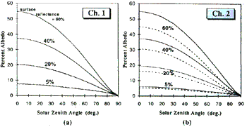
Figure 1 Effects of solar zenith angle to AVHRR Ch.1 and Ch.2 simulated by LOWTRAN-7
As shown in figure 1(a) and (b) the influence made by atmospheric model (which means difference of quality of water vapour in atmosphere) larger on Ch 2 than on Ch. 1 one of the reason for the phenomenon can be explained as the absorption caused by water vapour in Ch.2 wavelength region is greater than Ch. 1 wavelength region. Therefore, NDVI or (CVI) value calculated from count value (0 percent albedo) of Ch. 1 and Ch. 2 also must be influenced by quantity of water vapour in atmosphere.
In order to investigate the effect of solar zenith angle on CVI value, simulation of LOWTRAN-7 was performed for two land cover types (desert and forest) under the following condition. 1) Desert : Surface reflectance of Ch. 1 with 45%, Ch. 2 with 50% with dry atmosphere condition. 2) Forest : Surface reflectance of Ch. 1 with 10%, Ch. 2 with 30% with wet atmosphere condition. Figure 2(a) and 2(b) show the results of the simulation. As these figures indicate on both land covers. CVI values are not consultant on solar zenith angle. Especially, on large solar zenith angle (over 60°), slopes of CVI curve become very large. Other important fact is although CVI curve increases with solar zenith angle under the desert condition, forest and land cover shows the opposite tendency. Additionally, it can be seen that the rate of CVI change with solar zenith angle on forest is larger than on desert. These facts indicate that the effect of solar zenith angle on CVI value depends on particular land cover type.

Figure 2 Effects of solar zenith angle to CVI simulated by LOWTRAN-7
Factors of Solar Zenith Angle Variation
Figure 3(a). 3(b) and 3(c) show the temporal variation of AVHRR channel data (Ch.1 and Ch. 2), solar zenith angle and scan angle of a pixels selected from a desert located in Northern Africa. As shown in Figure 3(b), the variation of solar zenith angle can be divided into 3 components as high frequency variation within few weeks, seasonal variations of one year and low frequency variation which is increasing continuously. Following descriptions are cause of these variation except seasonal one.
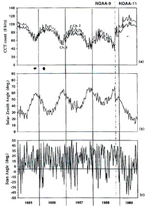
Figure 3 Temporal variation of AVHRR channed data, solar zenith angle and scan angle of a pixel in desert region
- High frequency component : Cause of high frequency variation is the slant viewing of the sensor on different path. As shown in figure 3(c), scan angle varies with high frequency. That means a local time of observation point varies in a few weeks period. Therefore, solar zenith angle also varies in same period.
- Low frequency component : Cause of low frequency variation is the delay of the equator crossing local time. As some researchers pointed out (Gutman 1990, Price 1991), the local time of satellite equator crossing in its life time. As the results of this delay, solar zenith angle becomes larger year by year.
Proposal of Channel Data Correction Method for Low Frequency Temporal Variation
As mentioned in previous section, temporal solar zenith angle variation can be divided into 3 components. In this section, a channel data correction method of the effects of low frequency solar zenith angle variation is proposed. A purpose of this channel data correction is to make NDVI or CVI data of different years that can be compare each other. Because, considering long term global monitoring, the low frequency variation of NDVI or CVI caused by solar zenith angle variation will make difficulties in change detection of land cover.
The basic concept of the correction method is adjustment of channel data between different years under the following assumption. That is, "even some land cover changes are take place, they will not influence the shape of histograms". On the other hand, situation things must be considered for histogram making and adjusting.
- The change of solar zenith angle by the delay of equator crossing time depends on the latitude of observation point and season.
- The effect of solar zenith angle of NDVI or CVI value depends on the land cover type described in section 3.
As the example of histograms of divided groups, histograms, of Ch. 2 data in different 52 weeks (one year) were shown in figure 4. These histograms were under made the condition listed in table 1. Figures 4(a), (b), (c) are the histograms of northern mid-latitude region in summer / Winder and figure 4(e), (f), (g), (h) are the histograms of 1985 data were divided into 4 digital count region (Level-1 to Level-4). Then histograms of 1987 data were made from corresponding pixels which belong to each digital count region in histograms of 1985 data. Similarly, in figure 4(b), (d), (f), (h) histograms of 1987 data were divided into 4 digital count region and 1985 histograms were made form corresponding pixels. Histograms adjustment should be performed to pairs of corresponding level-histogram (for example, level-1 histogram of Figure 4(a) and Level -1 histogram of Figure 4 (b).
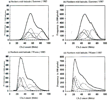
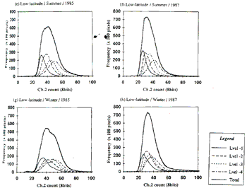
Figure 4 AVHRR Ch.2 histograms of divided region of latitude, season and digital count
Target of this research is to propose the idea of correction method. Further research should be carried out to verify the proposed correction method.

Conclusion
The effects of solar zenith angle to AVHRR channel data was simulated by LOWTRAN-7. It was found out that the degradation of percent albedo caused by increase of solar zenith angle is not the same for Ch. 1 and Ch. 2 it depends on the land cover type. As the results of this fact, solar zenith angle effects to NDVI also depends on the particular land cover type.
Temporal variation of the solar zenith angle can be divided into 3 components. They are the high frequency variation within few weeks, medium frequency of seasonal change and low frequency variation cause by delay of equator crossing time.
Proposed correction method to remove the effects of low frequency variation is the histogram adjustment of AVHRR Ch. 1 and Ch. 2 for divided data groups which are latitude, season and data level values.
Acknowledgements
Authors wish thanks to J. Kitami and T. Sugita and L.K.Perera for their assistance for the research work.
References
- Gurman, G.G. 1990, Towards monitoring droughts from space, journal of Climate, Vol 3 282-295
- Kidwell, K.B. 1986, NOAA polar orbiter data users guide, National Oceanic and Atmospheric Administration, Washington, D.C.
- Kidwell, K.B 1990, Global Vegetation index user's guide, National Oceanic and Atmospheric Administration, Washington, D.C.
- Matsumoto, M.T, Odajima, K. Kajiwara and R. Tateshi, 1991 Investigation of Solar Zenith angle dependence of NOAA GVI data and its correction. (In Japanese), Journal of the Japan Society of Photogrammetry and Remote Sensing, Vol. 30, No. 3, 34-41.
- Price, J.C. 1991, timing of NOAA afternoon passes, Int. J. Remote Sensing, Vol. 12, No.1 193-198
- Singh S.M., 1988, Lowest order correction for solar zenith angle to Global Vegetation Index (GVI) data Int.J. Remote Sensing, Vol. 9, Nos 10, and 11, 1565-1752.