| GISdevelopment.net ---> AARS ---> ACRS 1991 ---> Plenary Session |
Remote Sensing activities in
India - XII
M. G. Chandrasekhar, K
Radhakrishnan, V Jayaraman
B Manikiam and P P Nageshwara Rao
ISRO Headquarters
Bangalore - 560 094 , India
B Manikiam and P P Nageshwara Rao
ISRO Headquarters
Bangalore - 560 094 , India
Abstract
Significant progress has been made in the operational utilization of remote sensing techniques in various natural resource sectors in India. With the continued availability of high quality data from Indian Remote Sensing Satellite series, several major national projects have been completed successfully and many new projects have been initiated in various application themes. The demand for IRS-1A data products has shown increasing trends during the year indicating higher utilization of satellite data/ Presently more than 80% of the user demand for satellite data in the country is met by IRS-1A. IRS-1B, the next satellite in the series and which is identical to IRS-1A is scheduled for launch during August 1991. With the planned reception of micro-wave data from the European Remote Sensing Satellite , ERS-1, microwave data is expected to be available by the year end, opening new avenues to the Indian users for microwave data applications. Towards achieving Natural Resources Information System (NRIS) for the country , several pilot projects have been undertaken and they are progressing well. The activities at the State Remote Sensing Application Centres are on the increase with their active participation in the national level projects apart from specific projects for the States development. They training centres continued to contribute towards developing appropriate trained manpower in the country in remote sensing. This report highlights the progress of remote sensing activities of the country during the last on year period.
Introduction:
India has achieved remarkable success in utilization of remote sensing technology for the developmental activities of the country. The experimental efforts initiated in the early 80's have borne fruits and has culminated in the use of space based remote sensing in most of the natural resource sectors viz. water, land use, agriculture, forest , soil, minerals and environment. The successful launch of IRS-1A, the indigenously developed remote sensing satellite, in March 1988 marked yet another major milestone in the development of remote sensing in the country. The data available from IRS-1A presently forms the major source of remote sensing data for the country's user community. The follow on satellite in the series, IRS-1B scheduled for launch in August 1991 will ensure continuous availability of remote sensing data. All these efforts have contributed significantly to the establishment needs of the country. The other programmatic elements being pursued under the NNRMS are facility/infrastructure build up, development of operational methodologies in newer application areas such as microwave, information systems, Digital Terrain Model (DTM) etc and training/manpower development. This paper highlights the major achievements under the NNRMS and the future plans.
2. Space and Ground Segment:
The IRS-1A satellite is functioning normally over the past three years and has provided more than 3,50,000 data products. The switching over of preference of several users from Landsat and SPOT to IRS-1A data indicates the comparable quality and spectral characteristics of the IRS-1A to meet the requirements of the users. The multiband data from IRS-1A in the visible and near IR region have been extensively tested regions and seasons, specific look-up tables have been arrived at to generate best quality data products. New types of data products have been introduced in the form of special geocoded and enhanced products supplied in CCT as well as floppy formats. An extensive network of ground control points (GCP's) identified across the country is aiding in achieving high level of cartographic accuracy of the data products.
The data reception facility at Shadnagar near Hyderabad while continuing to receive data from IRS-1A, Landsat and NOAA (SPOT reception was discontinued since January 1991 in view of very low user demands), has been upgraded to receive the low bit rate SAR data from ERS-1 satellite under an agreement with ESA. The Data reception from ERS-1 is scheduled to start from end August 1991. The Data Centre at National Remote Sensing Agency, Hyderband caters to the dissemination aspects of satellite data and is coordinating the efforts with data acquisition and processing facilities through an Integrated Information Management system ( IIMS). A turn around time of better than 15 days have been achieved with the dedicated efforts of various units of Department of Space. The Space Application Centre at Ahmedabad supports these activities through the development and implementation of specific software programmes for the generation of special products.
2.1 IRS follow-on series
Towards ensuring availability of remotely sensed data to the user community on a continued and enhanced basis, the programme on the series of satellites under IRS-1 is being pursued vigorously . The next satellite in the series, IRS-1B which is identical to IRS-1A, is scheduled for launch in the last week of August 1991. The second generation satellites in the series, IRS-1C and IRS-1D, planned during the mid 1990's, are designed-to carry sensors with resolutions of 20 metres in multispectral bands and better than 10 meters in the panchromatic band. These satellite will also carry a short wave Infrared ( SWIR ) sensor with nominal resolution of 70 meters and a wide Field Sensor ( WIFS ) with 188 m resolution and wide swath of 770 kms. These satellites will have capabilities for revisit, stereoviewing and onboard videorecording. Development of an airborne C-band ( SAR) is in progress towards realishing sar systems for future satellites missions.
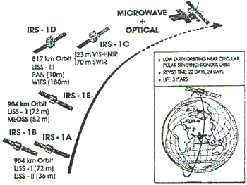
IRS Mission
3. Achievements in Remote Sensing Applications
Major milestones have been accomplished in the remote sensing utilisation for development activities at national, regional and district levels. The achievements cover almost the entire gamut of natural resources providing operational services for mapping , monitoring and management besides providing valuable inputs towards relief measures in the case of natural disasters such as drought and floods. With the National level Standing Committees ( under the aegis of NNRMS ) on agriculture, water, ocean resources, bioresearches, geology number of application projects have been successfully completed and new ones have been taken up. The following sections briefly highlight the significant progress.
3.1 Agricultural Crops
Multidate, stratified sampling techniques developed and validated over the past 3 years is being utilized towards estimation of crop acreage of rice, ( Orissa and Tamil Nadu ) wheat ( Punjab Haryana, West Uttar Pradesh, Rajasthan ), Sorghum ( Maharashtra and Karnataka ) and Groundnut (Gujarat ). These estimates provided almost one month in advance of that obtained through conventional reporting system, has become an important input for the Agriculture policy and planning purposes. testing in the 1990-91 season for rice and wheat has proved to be encouraging. Crop acreage estimation has also been initiated for cotton, mulberry ( for Sericulture), tea and tobacco.
Under the national level drought monitoring and assessment project, normalized vegetation index data is being operationally used to identify drought affected areas towards implementation of relief measures. Efforts are underway to extend the project to taluk level and also to attempt drought forecasting using agrometerological parameters. Towards identifying landsmot low productivity , detailed mapping of saline / alkaline affected lands especially in the North and North West parts of the country is being carried out in collaboration with National Bureau of Soil Survey and Landuse Planning. Quantification of levels of salinity/alkalinity through digital
3.2 Landuse / cover and Land Management
Landuse / cover mapping of the entire country on an agroclimatic zonal basis, is progressing well, with the scheduled date of completion of the project being end 1991. Both visual and digital methods are being utilised in this mammoth task being carried out in collaboration of 20 user agencies in the Central and State Governments. These maps provide fallow lands, forests and wastelands.
With the positive feed back received from the National Wasteland Development Board on the wasteland maps ( on 1:50,000 scale ) generated for 147 critically affected districts, the second phase of the project covering additional 84 districts has been initiated. The wasteland mapping project proved the time and cost effectiveness of the use of remote sensing techniques by providing within a short period of 12-15 months detailed wasteland maps showing village level details for 147 wasteland reclamation in the country taken towards increasing the agricultural production and fuel-weed/fodder output.
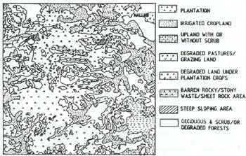
Landuse Map of part of Hassan District
Methodology development using high resolution data ( LISS II of IRS-1 and SPOT ) is being used to map the urban sprawl of the 12 major cities in adopted these maps as the baseline information for perspective planning of their growth. Geographical information system has been utilised for analysing to solve the related problems. In a typical study, the IRS-1A, data was used for suggesting a suitable alignment for the Ring Road around Bangalore City.
3.3 Forest Monitoring and Management
Biennial forest mapping of the entire country on 1:250,00 scale is being carried out by Forest Survey of India. The forest cover mapping over the past decade has indicated the positive effects of afforestation programmes by way of reduced deforestation rates of 45,00 ha/ yr during 1982 - 86 period. The National Forest Data Management Centre ( NFDMC) with computer based analysis facilities has plans to extensively use digital analysis techniques to monitoring forest cover changes and dynamics.
Pilot scale studies initiated in the areas of grassland mapping, wild life habitat assessment, environmental impact of mining, desertification in North West Indian and desert locust migration have given highly encouraging results.
3.4 Mineral Resources
Project Vasundhara initiated in 1987 in collaboration with Department of Mines has resulted in developing operational methodology for of Mines has resulted in developing operational surveys to arrive at potential indicators of mineralisation zones. An indigenous GIS ( INGIS ) developed under this project is being operationally used for the detailed study of selected test sites. Geostatistical models are being developed for specific mineral groups.
3.5 Water Resources
Considering the importance of water management in the country which is blessed with major river systems and high rainfall during the monsoon seasons, several projects have been completed harnessing the potentials of remote sensing technology for water management and development. The thrust areas of applications have been surface water monitoring, groundwater potential zone mapping, watershed management, snow melt runoff prediction and flood damage assessment.
Under the Drinking Water Technology Mission (DWTM ) the entire country has been mapped for groundwater potential zones ( on 1:250,000 scale ). These maps prepared based on the Geology, geomorphology and other associated factors categories the groundwater potential as poor, moderate and good. these maps are being extensively used for source finding of drinking water for over 2.5 lakhs problem villages in the country. The feed back received from the drilling of over 1, 00, 000 wells has shown that the success rate achieved using the remote sensing based maps are in the range of 85-92% compared to 45-50% with conventional surveys only. R&D efforts are in progress for estimation conventional survey only. R&D efforts are in progress for estimation conventional surveys only. R&D efforts are in progress for estimation of groundwater yield and water balance of specific geological regions.
Snow cover areas information from satellite data is being used to provide seasonal forecasts of snow melt runoff for the Sutlej and Beas basins. The validation of models have indicated that the estimates are with in 2-4% of actual runoff.
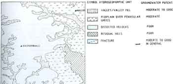
Ground Water Potential Map of part of Hassan District
Near real time flood mapping is being carried for all the flood prone river basins in the country with data available from the compliment of satellite on the extent of flooding and the damage caused to the standing crops. With the availability of SAR data from ERS-1 satellite, it is expected to fill in gaps in the satellite data coverage due to clouding obvert the flood affected areas.
Identification of erosion prone areas and prioritization of watersheds have been carried out for the Narmada catchment and the project is being extended to Brahmaputra basin. GIS based ,models are under development to derive silt yield index ( SYI) for different grid sizes through integration of parameters of landuse , land cover, runoff, geography, soil characteristics etc.
3.6. Coastal and Ocean Resources
Coastal maps prepared for the entire coastline of the country extending over 7500 kms is being put to use for the coastal zone management.. These maps provide data on coastal landform, landuse, coastaline dynamics, erosion prone areas, estuarine, mudflats, etc. Coastal maps also help in identifying potential inland water bodies suitable for aquaculture development.
The Sea Surface Temperature ( SST) maps generated operationally from analysis of NOAA - AVHRR data is being used to prepare weekly fishery potential charts. These charts are providing valuable information to the fishing community, leading to large increases in fishcatch. The methodology is being further fine tuned using the ocean colour information available from the blue-green bands of IRS-1A.
Pilot scale studies have been initiated to use the microwave data 9 Scaterometer, altimeter and SAR ) to retrieve ocenica parameters such as surface winds, waves, internal waves. Near shore bathymetry, oceanic circulation, thermal fronts etc/ It is proposed to operationalise these parameters with the regular flow of data from ERS-1.
3.7 Integrated Surveys for development at Micro level.
As part of the strategy of utilize remote sensing based inputs for developmental activities, integrated resource surveys have been taken up for 18 districts covering over 17 mha. These surveys are carried out in two stages - In the first stage, resource maps on land and water related parameters are generated and in the next stage, these maps are integrated with climatic and socio-economic data to arrive at local specific development strategies such as wasteland reclamation, soil conservation, alternate etc. It is proposed to extent these surveys to the entire country in a phased manner. Under this project, development of models through use of GIS and DTM have also been initiated.
4. National Resources Information System.
One of the major goals of NNRMS is the establishment of National Resources Information System to aid the planning and development process. The NRIS is conceptualised as a system with three hierarchial levels viz. National, Regional and Local with data organized for tactical, strategic and implementation levels of planning. The NRIS is tactical, strategic and implementation levels of planning. The NRIS is proposed to include data on socio-economic aspects in addition to the resource data base. The NRIS will included a communication network linking the districts in the country for realtime dissemination of information and updating of data bases. Presently a programme is being drawn up towards realization of NRIS. Several pilot scale projects have been undertaken in diverse resource themes to develop capabilities for data base generation, retrieval, updating and modeling for decision making. Under this programme, indigenous development of Geographic Information Systems have also been progressed to realize have been evolved in areas such as crop management, wasteland reclamations, groundwater management , river basin management, urban planning etc.
5. Infrastructure Development
With as many as 21 states in the country setting up state remote sensing centers, activities in the states are picking up. These Centers besides providing support to national endeavors, take up regional specific studies to solve local problems. These state centers are equipped with visual interpretation facilities and have plans to Equip with digital analysis facilities. The state centers of Uttar Pradesh, Tamil Nadu , Haryana, Maharashitra, Punjab have already acquired the image analysis facilities to the state governments in vital sectors of natural resources on a need basis. The five Regional Remote Sensing Service Centres (RRSSC ) set up by Department of Space respective at Bangalore, Dehra Dun, Jodhpur, Kharagpur and Nagpur are providing digital analysis and training services to the users in their regions. The RRSSCs are actively supporting the National Projects on Agricultural Crops, Land use/cover mappings, wasteland mapping etc. Several user departments at the central government such as CWC, SOI, CGWB, NBSS & LUP, GIS, ONGC, NIO, FSI, AIS & LUS etc. have established remote sensing facilities to meet their project requirements. Few Universities have set remote sensing laboratories to aid in the conduct of remote sensing courses in post graduate and research level.
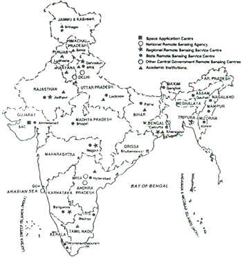
Remote Sensing facilities in India
6. Development of Interpretation Facilities Aids.
Over thirty indigenously developed interpretation and analysis equipment have been successfully technology transferred to industries and are being manufactures reoutinely. These equipment include visual interpretation aids such as optical enlarger, transferscope, spectrophotometers and PC-based image analysis systems, transfercope, spectrophotometers and PC-based image analysis systems. Mid-end image processing system ( MIPS) is being developed to meet the larger user requirements for digital analysis.
7. Training & Manpower Development
Considering the importance of trained manpower to conduct the remote sensing projects and to man the remote sensing facilities, specific training courses are being offered by the pioneering institutions - Indian Institute of Remote Sensing ( Dehra Dun ), Centre for Studies in Resources Engineers (IIT, Bombay ), and Institute of Remote Sensing (Anna University , Madras ) besides user departments such as GSI Training Institute, National Bureaus of Soil Survey and Land Use Planning , Forest Survey of India, Survey of India etc. The RSSCs are provided regular courses in digital techniques to the user scientists. Under the SHARES programme, scientists from developing countries are providing training at IIRS, Dehra Dun. The annual thruput of trained personnel covering various resource themes is about 825. Several Universities have introduced remote sensing courses in the postgraduate level. Department of Space and University Grants Commission have plans to introduce remote sensing in a phased manner in all the universities, as a strategy to inculcate an awareness of remote sensing among the future decision makers as well as to develop high quality manpower in each application theme.
8. Information dissemination and user interaction
Towards apprising the user community on the recent developments in remote sensing applications, several user meetings and discussions were organized on specific resource themes. Several technical reports / publications / application notes are brought out besides regular publications such as NNRMS bulletins, INTERFACE, etc., On-the-job courses were organized as part of the national projects to equip the user scientists to carry out the tasks.
9. Conclusions:
With the operationalisation of remote sensing application most of the resource themes, the NNRMS is entering the implementation phase. The resource management models that have been developed under the NNRMS are planned to be extensively validated for adoption at various planning levels. The integrated land and water management strategies arrived at through the Integrated Surveys projects are being implemented and validated for extension to other areas. The immediate R&D efforts will focus on microwave applications and technology development for indigenous systems of GIS, DTM & SAR. The second generation satellites IRS-1C/1D under development are poised to provide data with much higher resolutions and in middle infrared and microwave spectral regions.
With the emphasis shifting globe over to the emerging need for optimal exploitation of the various natural resources, keeping the environment in view. The satellite remote sensing is poised to play a key role in providing a holistic view of the natural resources. The integrated land and water resources surveys being carried out under the NNRMS is expected to provide further insights and help in developing appropriate strategies. With the advent of advanced technologies like Digital Terrain Modelling and Geographical Information System and availability of advanced sensors, utilization of remote sensing is geared to make a quantum jump in the later part of the 90's .
Acknowledgement
The authors gratefully acknowledge the valuable inputs provided by the multitude of users in the country in the country in preparation of this national paper. The secretarial assistance by Mr R Murali, Ms S Vanaja and Ms M Sameena is gratefully acknowledged.