| GISdevelopment.net ---> AARS ---> ACRS 1991 ---> Oceanography |
The Application of the ways
of systematic theory and information Theory to Marine Satellite Remote
Sensing
Li Tie-fang Zhongshan
Univ., P. R. China
Yi Jian-chun Univ. of Southern California, U.S.A
Yi Jian-chun Univ. of Southern California, U.S.A
Abstract
The authors analyses the transmitting process of the information obtained from marine satellite Remote Sensing, and regards it as a complex system composed of several random sub-systems such as atmosphere, water-body, seabed and the boundary of water-air, and the transmitted information has the features of grew and fuzziness, so as to limit the use of Remote Sensing data by physical or statistical model for extracting the informations of water body. The paper raised a valid way to extract marine information based on the theories of grey system and information.
- To use filter method for separating sub-systems;
- To use the idea of entropy (average information) to simplify physical model;
- To introduce the relative degree and correlation function of grey mathematics for evaluating the result of application of information extracting model, and for establisbing a relevant formula;
- To use the feed-back of information for controlling and interpreting image data on the basis of oceanology, geo-science, biology and expert knowledges.
Information has been regarded to be the third resources next to living beings and minerals which human being is developing and using, so the information of marine Remote Sensing are also taken seriously as a new marine resource. Based on our research for years, we developed some ways for analyzing, understanding and extracting the information obtained from Remote Sensing.
I. The systematical analysis of the transmitting precess of marine Remote Sensing information. The transmitting process for marine Remote Sensing information is shown as fig. 1.
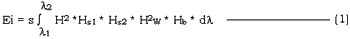
The information is transmitted through several different sub-systems such as atmosphere, water-body, and the boundaries of seabed and water-air and so on. The transmission function of spectral of each sub-system can be described as “H”, and then the spectral signal Ei received by the sensor of satellite can be written as
Ozone Water vapour Suspensate Wave, Current, Undersea landform Chlorophyll Silt content Water depth Suspensate Bottom materias Underseas landform
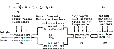
Fig. 1
The fig. 1 shows that the system is composed of several sub-systems with random medium and complex boundary which are reciprocally associated; Each sub-system is controlled and influenced by the changes of time and space, so the features of remote sensing information are as follows:
- Plenty of water information are transmitted;
- The matual influence of sub-systems make various sorts of information overlap and interfere one another , so as to become hazy;
- Both the indefiniteness of spectral interpretation and the availability of time and space made the system carry the feature of grey.

In actual application, the establishment of the numerical function of formula (2) is still difficult, because it is hard to get the parameters of an object. Therefore, at present for its use it mostly is to establish a semi-experienced statistical model of formula (2) in the practice, which is

Here : Y : the value of parameter measured over the sea at the same time as satellite passing through.
a and b : regression coefficient
F [ ]. the Remote Sensing data processed by some ways.
If monitoring points are so few that the number of sample could not weet the rule of large sample of statistics in a sea area with large changes of time and space, the calculating error of this formula will be too large to use.
II. The introduction of theories of system and information.
As marine Remote Sensing data is a kind of comprehensive information and its transmission is a systematic process, the method of system theory and information theory should be used to extracting the information needed, according to the feature of the system, including paration of sub-systems, simplifillcation of physical model, introduction of grey mathematics and feed-back and control of information.
(A). The saparation of sub-systems and the application of wave-filter technique. According to systematic structure transmitted by marine Remote Sensing, sub-systems must be separated from the system, only so effective extraction of the information of sub-system will just be possible. The way of the saparation is to use an expanded concept of wave-filter, including the special division and digital filtering process of time, band and image. The last filtering purely belongs to digital processing which may be found in many relevant papers and do not discuss here, and the preceding 3 methods belong to image choice which are simple and effective technique. For example, if the image obtained by a satellite at the time of no-wind and no-waves is chosen, the information from sub-system of the sea surface will rearly equal zero which can be regarded as that there is no interference of the sub-system in water-body information of the system. On the contrary, if satellite image at the time of wind and waves is chosen, the sea surface will be very rough, only small part of optical energy enter water-body, which can be regarded as that the information from surface sub-system is equal to zero, and the information from sea-wind field and current field on the sea. Otherwise, in order to eliminate the interference of atmosphere sub-system, the region division of image can be use to determine its influence. Because the sphere sub-system just n the image corresponding to a calm sea area with the water depth of over 40m, so the influence of atmosphere can be dispelled from whole image.
In the actual application of it to concrete object, clever choice and composition of several wave-filtering method can produce good effect. In a research on extracting the information about Sargasso weed in Daya Bay, we chose the relevant images of time, bands and regions for processing according to the time in which Sargasso weed grow and fall-off, the conditions of landform and water depth in which Sargasso weed grows, so well determined the distribution and growth density of Sargasso weed.
(B). The estimation of information content and the simplification of physical model. The information content of a certain image point in an image is a probability function of brightness which can be written as
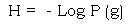
Here: g: the brightness of an image point
P (g): the probability as the brightness is g and
P (g) obeys the normal distribution N (sg, sg)
According to the maximum entropy theorem in information theory, the average information content (entropy) is as follows: ( Lin Zhong – jian, 1988; and Johannes, 1980 )
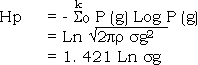
It is shown that for a certain kind of image points, its entropy can be calculated out after its deviation is found, so its information content or interference degree of atmosphere sub-system ca be estimated by the entropy of the image points where the water-depth is over 40m.
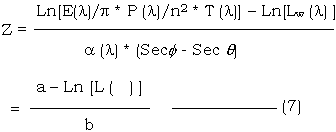
The concept of overage information content can be used to simplify physical mode. For example, after the separating process has been done, water sub-system Lw in formula (2) can be extracted out and the result is a s follows:

It is known from the concept of information content that sun-irradiance E (l), sun-angle f, visual-angle q and atmospheric transmittance T (l) can be regarded as constants in the same image, so their information contents all are zero ; P (l), a (l) and n2 can be also regarded as constants and their information contents also are zero when bottom materials and medium in water are well-distributed ; so Lw (l) is mainly the information of water-depth Z.
Here:
a and b are constants, and their information contents are nearly zero. Formula (7) is a simplified physical model of water-depth. For the same principle, the simplified model of a(l) (bottom materials) and a (l) (chlorophyll in water, silt content, oil membrance and so on) can be got according to the concrete conditions in a sea area.
(C). To apply grey mathematics to marine Remote Sensing. The transmitting process of marine Remote Sensing information is actually a grey system with multiple variables, including known information and some unknown information, being situated between the white system with all information known and the black system with all information unknown.
For different systems different data processing methods should be used. For a grey system, its data processing is to fully use known information. In an actual marine research, the number of sample is significant, because the sample is very difficult to collect synchronously when the satellite passes over the sea. In a broad sea-area, even though several or teens sampling points could not be thought to be enough for it. In such case, the mathematical models built with statistics are often of bad steady, and large fluctuarions are often seen as the sampling points increase or decrease by one or two, hence larger error would be bring about with using such models. So we tried apply grey mathematics to marine Remote Sensing research and good improvement was achieved. The detail can be seen in our another paper. “The Remote Sensing Grey Model causes of using grey model being able to Marine Silts suspended”. The causes of using grey model being able to improve the precision of estimation of silt are as follows:
- The way of relative degree analysis is less affected by small sample.
- The processing of data adding up improved the linear feature of data, so that it can match with actual changes of silt content.
- The values of different brightness are separately transformed by different ranges, so the total error will be decreased.
- The processing of data adding up may fully use known data, and to some extent, the processing is equal to the processing of signal overlay, so as to enhance the signal/noice rate.
- The feed-back and control of information
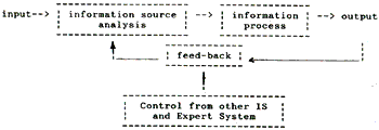
Figure 2 Marine Remote Sensing Information Procession System
The procedure of the feed-back is completed through man-computer interaction and re-processing control the control is based in the knowledge of the concrete problem such as oceanology, geoscience, ecology and so on. This processing system has wide-ranging contents and various methods of process, and actually forms a marine information system for marine research.
III. The prospect of applying information theory and systematic theory to the exploitation and use of marine Remote Sensing informations.
As development of Remote Sensing technique, improvement of remote sensor and processing method, and development and improvement of random medium vector-radiation theory, wave interpretation theory and random rough-surface scattering theory, more physical parameters with higher precision would be acquired and the nature be more exactly simulated so the information system will decrease its grey feature and increase its white one, therefore, the information sources will be more valuably applied. But as the laws of oceanology and geoscience are the results of synthetical action of many factors, there must be the effects of overlay, interference, fuzzy, and even annihilation among various information, and therefore it is inevitable to use the methods of systemic theory and information theory for analysis of information stracture and extracting target information. Indeed, the development of nerve-network computer will pave new ways of the use and exploitation of marine remote sensing information.
References
- Li Tiefang et all, The Extraction and Application of the information obtained from marine satellite Remote Sensing, Ocean press, 1990, China.
- A. Ishimaru, “Wave propagation and scattering in random media” Academic Press, N.Y., 1978.
- A.P. Cracknell, “Remote Sensing in Meteorology, Oceanography and Hydrology”, Ellis Horwood Limited, N.Y. 1981.