| GISdevelopment.net ---> AARS ---> ACRS 1991 ---> Mapping from Space |
Relevance of microwave Remote
Sensing to India
Jacob Ninan, B Manikiam, M
G Chandrasekhar
Indian Space Research Organisation Headquarters, Bangalore
Indian Space Research Organisation Headquarters, Bangalore
Abstract
India has made extensive use of remote sensing data for the study, mapping and monitoring of the country’s vast store of natural resources, beginning with the use of aerial data and Landsat data followed by imagery from the IRS-1A. The impact made by Remote Sensing on the national and regional level management is substantial. However, the use of microwave data can fill a crucial gap in the data collection over land by surmounting the problem of cloud cover. Also, the new areas of applications opened up in the areas of oceanography and climatology by microwave sensors will provide much additional information. With this in view, India is planning to receive the data from ERS-1 SAR data at the Hyderabad ground station, as well as acquire the data from the other sensors on ERS-1 from ESA off line. A C-band airborne SAR is being developed in the country towards obtaining data for experimental the technology needed for the development of a space borne version of SAR in future.
The paper proposes to discuss the specific areas where microwave Remote Sensing is expected to contribute considerably in the natural resources management in the country for land, ocean, and climatologically applications. The projects being undertaken specifically using ERS-1 data will be mentioned, as also the plans for the airborne SAR under development.
Introduction
India is a subcontinent with an area of over 3 million sq. km. with a vast availability of natural resources and a population of over 800 million people with diverse cultural and social practices. The major challenge facing the planners is to develop and utilize both these resources in the best possible manner. The aim of using remote sensing techniques is not only to map and monitor natural resources, but also to provide timely inputs for the national, regional, state and district level planners to develop appropriate strategies to provide a healthy linkage between the human and natural resources of the country. The advantages of satellite Remote Sensing in providing data and information on a timely and cost effective way over large areas are increasingly being utilized.
Optical Remote Sensing.
India was one of the earliest among the developing countries to explore the potentials of Remote Sensing. Starting with end to end experiments using data from airborne surveys and followed by data from Landsat, it was demonstrated that these techniques can be made use of to bring out tangible benefits. In the early eighties India embarked on the development of the country’s own Remote Sensing satellite series IRS-1. IRS-1A, the first satellite has been providing excellent data for more than 3 years now. The impact made by Remote Sensing in the country’s development front is reported elsewhere.
As is well known by now, satellite Remote Sensing in the visible and infrared regions is hindered by the presence of clouds, and this situation is further aggravated by the low frequency of revisit possible. Microwave Remote Sensing over land is being developed manly to overcome this problem, and this advantage shadows other gains in terms of extra information which is itself not negligible. Over the ocean, however, microwave Remote Sensing provides data which has not been so far available from other sources, feeding into studies not only in oceanography but also in climatology.
Need for microwave remote sensing- Indian perspective
Flood management.
It has been estimated that 59 MHa of area is prone to flood damage in India out of which flood occurs recurrently in about 40MHa. Flood occurs from the monsoon rains as well as from the snow melt-off from the Himalayas. In the case of the south west monsoon, typically 50% of the total rainfall occurs in less than 30 days, giving rise to floods. Along with heavy discharges, floods bring large volumes of sediment, and their deposits change river course. Landslides affect flood prone areas. Plains with agriculture suffer due to poor drainage.
Timely information on flooded area, watershed areas, river behaviour and configurations etc prior to the flood, during the flood and after the flood, is necessary. Satellite data suitable for mapping/ monitoring 1) extent of damage to crops, structures etc, 2) flood inundated area and drainage congested areas 3) river configuration, silt deposits, shoals etc and vulnerable areas of bank erosion and 4) watershed characteristics and land cover/ land use in command areas.
In the visible spectrum water can be easily distinguished from contrasting surfaces such as white sand, snow etc. But it is almost impossible when these areas are surrounded by wet soils, meadow grass and cultivated land. In these cases, near IR ( > 800nm ) have to used. However, the time of flood is also associated with heavy cloud cover, and coverage is many times severely restricted for optical remote sensing. SAR data used in conjunction with optical data will help making better estimates of damages and remedial actions can then be taken with greater accuracy. The possibility of differentiating moist and dray land can add greatly to the information. Another application of SAR data will be in differentiating cloud and snow towards snow mapping and the estimation of water content in snow for forecasting floods from snow melt-off.
India has been making use of optical satellite Remote Sensing data for flood management for 16 years. Flood mapping, identification of flood prone areas, taking measures for prevention and control of floods, flood damage assessment and flood forecasting are being carried out regularly. Use of SAR data is expected to improve the accuracy and efficacy of these efforts in a large measure.
Crop monitoring
The success of agriculture in India depends on the timely onset, proper amount and distribution of rains in a season. The cropping patterns are therefore largely based on the seasons. With the exception of Jammu and Kashmir and, Tamilandu, 80-90% of the rainfall in the country is from the South West Monsoon, which normally enters the south west state of Kerala in the end of May and progress to the entire country by the end of July. This monsoon lasts in various strengths till the end of September. This Kharif season is when most of the rice, jowar, bajra, maize, groundnut and cotton is grown. From November to May, light rainfall and snowfall occur in the north, which is made use of for the Rabi crops such as wheat, barley, oats, jowar and gram. The north east monsoon brings rain to the south east state of Tamilnadu from October to December and the rice crop in this region is linked to this season.
Satellite Remote Sensing is useful identifying the crop types in different areas, as well as in estimating crop acreage and yield. However, due to the fact that identification of type require multitemporal imaging at various stages of crop growth, the availability of could free data becomes critical. Though knowledge of regional cropping patterns is a great help, since farmers change their crops from time to time, periodic monitoring becomes necessary. Cloud cover has been seen to be the greatest hindrance in obtaining the required coverage. It is in this context that the use of SAR data is expected to fill a crucial gap in optical Remote Sensing data and improve classification accuracy to a large extent. Also, the ability of microwave data for differentiating corps according to their leaf and planting geometry is expected to yield additional information.
Soil moisture.
The spatial and temporal variation of soil moisture is valuable information for agricultural, hydrological and meteorological applications. Monitoring soil moisture can provide a very valuable input to drought predication. In the case of dryland farming it can be very useful for the effective planning of irrigation. Crop yield forecast models can me highly improved with the knowledge of prevailing soil moisture. Knowledge of soil moisture can provide an input for flood prediction since water absorption by the soil will depend on its present moisture content.
Using optical Remote Sensing, one can detect moist soil by its darker appearance compared to dry soil. However, a dark colour could also be due to soil type or a change in sun elevation. The main limitation in this case is that the measurement is very superficial. Use of thermal infrared can also provide only surface information and errors can be caused by the fact that an evaporating surface appears cooler than another surface. Passive microwave sensing provides a measurement of surface soil moisture because moist soil has less emmissivity than dry soil. However the spatial resolution here excludes any study other than a macro level survey. Radar can provide data on soil moisture due to the effect of moisture on the dielectric constant of the soil.
SAR can penetrate moderate vegetation cover to provide soil moisture estimation, and in the case of soil with low moisture content, it can provide sub surface soil moisture information to various depths depending on the radar frequency.
Though SAR can provide information on soil moisture which is not available from optical Remote Sensing, much study remains to be carried out in the interpretation of data. For example, modeling has to relate the near surface moisture indicated by SAR to the root level moisture, n the case of agriculture. Since SAR data is also related to the roughness of the surface, the slope of the terrain, soil type and radar frequency and polarization, extraction of soil moisture has to be done carefully.
Ocean monitoring.
It is now recognized that Remote Sensing from space is the only practical way to monitor the vast regions of the ocean on a repetitive basis. Microwave Remote Sensing throws open the possibility of obtaining data which has not been possible with the use of optical Remote Sensing. Passive microwave sensors can measure sea surface temperature, atmospheric water vapor over the ocean, rainfall over the ocean, surface wind speed etc, while active sensors such as scatterometer, synthetic aperture radar and altimeter can provide information on wind velocity, surface topography, wave spectra, ocean currents and circulation, internal waves, ocean bottom topography, near shore bathymetry, gyres and eddies, oil slick spread etc. The fact that measurement is possible in the presence of clouds makes this all the more attractive.
India is undertaking a major effort to make use of Remote Sensing techniques to monitor the ocean and derive parameters required for tapping the recourses from the ocean, for designing ocean and coastal structures, for shipping etc. Sea surface temperature derived from NOAA satellites is currently made available to the country routinely, and weekly broadcast on fishery potential are being made. Microwave data from ERS-1 is awaited eagerly for studying the possibilities above. Since such data is going to be available routinely over Indian ocean for the first time, it is clear that a large amount of research efforts will be required in order to be able to disseminate such information routinely.
Climatology.
Surrounded by ocean on three sides, the Indian climate is very much influenced by the nearness of the ocean. The ocean parameters such as temperature, surface wind, air sea interaction due to waves etc shape the climate over land. A good example is the effect of ocean on the monsoon. Data over wind, wave, atmospheric water vapour, rainfall, ocean currents etc can feed into climatic models and improve their accuracy.
Past experience with microwave sensors.
Experience with space born microwave sensors is limited globally. SEAST of 1978 provided a large amount of data from its passive and active sensors during its short life, and this is still being analysed in different parts of the world. Shuttle Imaging Radar A and B gave a limited amount of SAR coverage in several places. GEOSAT altimeter data was available till recently over the oceans. India made an entry into microwave remote sensing with the development and operation of microwave radiometers at 19, 22 and 31 GHz named SAMIR on its first Remote Sensing satellites Bhaskara 1 and 2 launched in 1979 and 1981 respectively. Studies related to atmospheric water vapour content, sea surface winds and rainfall over the oceans were carried out using this data. SEASAT did not collect any SAR data over India, but India scientists have carried out studies of wind and waves using data from the scatter meter, altimeter and scanning microwave radiometer. SIR A and B have provided some coverage over India and this data has been examined to obtain a first hand experience in the use of SAR data. Subsequently aerial SAR flights using the X-band system from Intera Technologies, Canada have been conducted over several test sites in the country for detailed studies in various disciplines.
India has also developed microwave Remote Sensing hardware such as a transportable 1-18GHz scat- terometer with multiple polarizations and look angles and two X-band SLAR systems. The scatterometer has been used for studying the signatures of different conditions of soil and vegetation varying with microwave frequency, polarization and look angle. SLAR flights have been carried out to study different land features including snow as well as wave patterns in the sea. A C-band airborne SAR is currently under development.
While data availability has been limited, Indian scientists have gone ahead with empirical as well as theoretical analyses of the possibilities of using microwave data. These attempts include the determination of the velocity of ocean gyres through SAR, determination of swell height from altimeter data, the relationship between scattering coefficient and wind speed for specular scattering, estimation of scattering coefficient from sea spectrum, wind-wave relationship from altimeter and scatterometer data, choice of optimum frequency for wind scatterometer, measurement of wind from radiometer data, retrieval of wind vector from scatterometer data for SEASAT and ERS-1, effects of whitecaps and foam on wind measurement from altimeter, cyclone structure using microwave sounder data, retrieval of atmospheric water vapour and precipitable water from radiometer data, etc. Studies over the land include soil moisture and the relationship with radar parameters and vegetation cover, identification of land features in SLAR and SAR images, supplementary nature of SAR data along with optical data for crop identification, identification of geological features from SAR data, speckle reduction studies for SAR data, image enhancement techniques applied to SAR data, snow mapping, etc.
Proposals to use ERS -1 data.
The arrival of regular data from ERS-1 instruments is being looked forward to in the context of exploring the full potential of microwave Remote Sensing data in the country. Seven projects are under way in response to the announcement of opportunity from ESA for experiments using ERS-1 data. These are:
- To detect and map soil moisture in dry land farming areas.
- To detect and map soil retrieval algorithm and to model the relation ship with subsoil moisture.
- Case studies in the use of C-band SAR geological and geomorphological mapping and mineral exploration.
- To retrieve SST from ATSR and microwave sounder, to classify clouds, and to study air sea interaction using SST and wind data.
- To study ocean internal waves with respect to the generation, propagation and dissipation and their effects on upper layer mixing, and their relation to cyclonic wind stress.
- To study Arabian Sea eddies from thermal data, wind data and slope data.
- To assess the improvement in medium range monsoon forecasting using surface winds.
In addition, several agencies and scientists in the country are planning to assess the suitability of ERS-1 data for their specific needs. The Department of Space, as the nodal agency, is also planning to take up several small scale investigations in this connection.
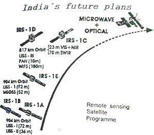
India's fututre plans
India’s bold step in going ahead with the design, development and operation of its own Remote Sensing satellites of the IRS-1 series has been demonstrated to have been taken rightly, from the fact that several national, regional, state and even district level activities have come to be linked up with the availability of satellite data. The demand for Landsat data is increasingly being replaced by IRS-1 data. In addition, the technological thrust provided by the development of the satellites has been of major benefit. In the context of bridging the gap in the availability of data during periods of cloud cover , and also obtaining important information over the oceans which has not been available so far regularly, the Department of Space is considering the development of microwave Remote Sensing satellites in the coming years.
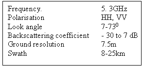
As an initial step in this direction, a C-band SAR is being developed presently for airborne operations, not only to acquire the technology but also to have a platform for detailed experimental studies on a sampled basis. The system is planned to be ready for flight by the end of 1992. The broad specifications of this
C-band airborne SAR
Conclusion
The new and promising field of microwave remote sensing is of great relevance to a country like India, due to the well known advantages it can offer to a vast tropical country like India with a large expanse of ocean around its three sides. This paper has attempted to address this subject with reference to some examples of specific requirements and also the programme being undertaken to harness this potential.