| GISdevelopment.net ---> AARS ---> ACRS 1991 ---> Mapping from Space |
Inter Sensor Comparison of
Indian Remote Sensing Satellite - 1A Linear Imaging Self Scanning Sensors
for Radiometric behaviour
J. Kirshnamurthy, A. S
Padmavathy, V. Jayaraman & Uday Raj
Earth Observation Systems Programme Office
Antariksh Bhawan, New BEL Road
Bangalore - 560 094
RRSSC, Bangalore
Earth Observation Systems Programme Office
Antariksh Bhawan, New BEL Road
Bangalore - 560 094
RRSSC, Bangalore
Abstract
Remotely sensed data usage from multisatellite, multisensor calls for handing different spatial, spectral and radiometric resolution data for extracting details of interest. Temporal changes also need to be understood while one tries to use multi satellite data. The preparation of a digital mosaic from data acquired by different satellites /sensors, study of change detection of dynamic process form multi temporal data sets, ratio of spectral bands to eliminate differential illumination effects, etc. require the understanding of inter-relationship between digital number from the sensors and radiance from an object to establish an absolute calibration basis. Looking at the same scene from different sensors at the same time could help evolve a relationship between the participating sensors. However, altitudes, local times, etc., differ for the sensors, making it further difficult to inter-relate their radiometric performance. In the present study, an attempt has been made to compare the radiometric behaviour of IRS-1A LISS-I with LISS-II which are acquired simultaneously having all these parameters identical, except for difference in the spatial resolution. The digital number values obtained for various landuse /land cover features, such as water, vegetation, soil, rock, sand etc., are converted into spectral radiance for comparison of both LISS-I with LISS-II data.
The comparative analysis of selected land cover features show that there is a definite relationship between both the sensors. Linear curve fitting and the correlation coefficient value obtained for each of the bands of both sensors suggest that the spectral radiance recorded at the sensors are in agreement.
Introduction
Satellite Remote Sensing technique has proved to be an effective tool in resources survey, mapping and monitoring. Availability of data from multi satellite, multi-sensor in different spatial, spectral and radiometric resolution provide an opportunity to the users to choose the right type and formal of data products to extract the details of interest. The digital image analysis of remotely sensed data has the added advantage over visual interpretation technique in manipulating the data for specific enhancements, classification etc. apart from providing quantitative information.
The digital data in computer compatible tape (CCT) is represented by dimensionless Digital Numbers (DN) which doesn't quantitatively represent real physical units. The preparation of a digital mosaic from different satellites and multi-sensor data, study of change detection of dynamic processes from multi temporal data, elimination of differential illumination effects by spectral band rationing etc. require the understanding of inter-relationship between digital count and reflectance from an object. DN value depend on the characteristics of the object atmospheric column between the object and the sensor and the calibration of the sensor. When two or more sensors view the same object simultaneously, the sensor calibration becomes more significant than the characteristics of the objects and the atmosphere. Therefore, the conversion of DN values to either radiance, (as measured at the satellite) or reflectance from the object will be essential for understanding the relationship between the sensors. In the present study, an attempt has been made to compare the radiometric behaviour of Indian Remote Sensing Satellite (IRS-1A), Linear Self Scanning Sensor (LISS) -I with LISS-II which acquire data simultaneously with all the sensor parameters identical except for difference in spatial resolutions.
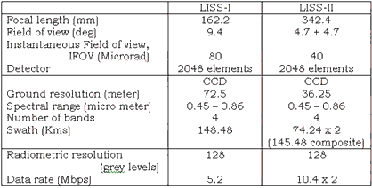
Characteristics of IRS-1A Sensors
IRS-1A has two types of imaging sensors, one with a spatial resolution of 72.5 meters and designated as LISS-I camera and other two separate imaging sensors designated as LISS-II A and LISS-II with spatial resolution of 36.25 metres each. The unique feature of these sensors are that they operate in four spectral bands covering visible and NIR region. Refractors type of collecting optics, with spectral selection by appropriate filter is used for each of the four spectral bands of LISS-II& LISS-II sensors. The use of individual lens assembly for each band, optimizes the performances in each spectral band and effectively utilises the full dynamic range of Charged Couple Devices (CCDS). Facilities exists for controlling the individual band gain setting through ground command and four selective gains are available. The ground command and four selective gains are available. The characteristics of LISS-I and LISS-II sensors are given in Table 1.
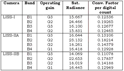
Gain setting and saturation radiance
The saturation radiance values are calculated using the six intensity levels covering the full dynamic range. The pixels of a detector have non uniformity photo response. For saturation radiance computation, the pixel with maximum count value is considered. The saturation radiance and the conversion factors applicable for the operating gain settings for the different IRS-1A LISS sensors or the four spectral bands applicable to ratio-metrically corrected and non stretched digital grey values are given in the Table -2.
Objective
The objective of this study is to compare the IRs-1A LISS I dat with LISS II data for radiometric behaviour, by converting DN values to spectral radiance for different features like water, vegetation soil, rock etc.
Data Used
Standard CCT corrected for earth rotation, radiometric and geometric corrections with location accuracies of + 2.2 km has been utilized. IRS-1A LISS-I and LISS-II A1, B2 data corresponding to path 26 row 58 of April 26, 1998 of parts of Andhra Pradesh and IRS-1A LISS-I and LISS-II A1 and B1 data corresponding too path 26 Nov. raw 59 of April 22, 1990 of parts of Karnataka were the data set. The LISS-I and LISS-II data acquired simultaneously was utilized for the study since the data set does not require any atmospheric correction for normalization.
Methodology
Digital image processing facility configured around VAX 11/780 computer available at Regional Remote Sensing Service Centre (RRSSC), Bangalore was utilized for the study. Data for the common area in both LISS-I and LISS-II was extracted from the tape for detailed analysis. While the LISS-I subscene comprised of 256 x 256 pixels. The same are in LISS-II is represented by 512 x 512 x 512 pixels. The LISS II sub scene has been compressed to 256 x 256 pixels by omitting one alternative line and column and the same has been superimposed over LISS sub scene with different band combinations for image cover LISS sub scene with different band combinations for image co-registration. It has been observed that the registration was perfect.
In order to compare the DN values of LISS-I data with LISS-II data different landuse/land cover features such as water, vegetation, sil, rock, sand etc., have been chosen. A mask subscene for LISS-II dat with different polygons representing different landuse/landcover features was created. Similarly another mask sub scene for LISS-I was created from LISS-II mask sub scene by omitting one alternative line and column to exactly represent the corresponding areas in both the data sets. Using these mask subscenes multivariate statistical parameters like minimum and maximum grey values, mean, standard deviation, correlation covareints etc., for each polygons was obtained by super imposing respective mask subscenes on both LISS-I and LISS-II data. Then the DN Values form polygons were converted to spectral radiance values by using the saturation radiance /conversion factor as given in table - 2.
Results and discussion
A DN-to-surface calibration procedures is critical to many applications like signatures extension, (temporally and / or spatially) automatic spectral signature identification, mosaicing of data from tow satellite / sensors, elimination of differential illumination effects, topographic normalization of digital imagery etc. Some calibration procedures now is use to convert image DN values only to top-of-the-atmosphere radiance and do not correct atmospheric effects. However, Pat S Chavey 91989) has observed that the conversion of mulitspectral imagery DN to surface reflectance cannot be carried out without the atmospheric corrections.
Charles J Robinove (1982) has attempted the computation of physical values from Landsat digital data of Landsat 1, 2, 3 and 4. The study has revealed the significance of physical values especially when internally non consistent image / data of different satellite / sensors are being used. It has been observed by the author that there is a significant different in radiance and reflectance for the same DN values that are caused in radiance and reflectances in calibration of the topographic effect from Landsat TM digital data has been described by Daniel Landsat cinco (1989). Based on the study it has been observed that the topographic effect can be removed by normalizing the satellite radiance data with digital elevation data and a corresponding solar irradiance model.
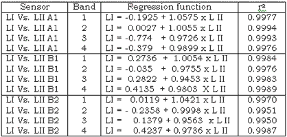
In the present study the comparison of DN values of LISS-I data and LISS-II data for path and row 26 - 58 B2 and 26 - 59 B1 shoed that in general Band 1 and Band 2 DN values of LISS-II data were higher than that of LISS-I, but the reverse was observed in Band 3 and Band 4 for all the feature classes selected fro the study. But for the data of path and row 26 - 59 A1 band 1 and band 3 of LISS-1 data have higher DN than LISS-II data. The inconsistent behaviour of DN clause observed makes it difficult to draw any conclusion on the comparability of LISS-I and LISS-II sensors. Therefore, DN values have been converted into radiance values by utilizing the saturation radiance of the each band of the sensors given in the Table - 2. Theoretically, the radiation emitted by a target recorded simultaneously by the two independent sensors should be ideally same. For comparison of the two sensors, the band wise curves were plotted for spectral radiance of different features for LISS-I and LIS-II sensors. Some of the plots are shown in figure 1 and linear regression function is given in the table -3. It can be seen from figure and table that a linear spectral radiance. The correlation coefficient obtained for band wise plots for LISS-I Vs LISS-II also suggests that the spectral radiance of the same targets obtained by the two sensors i.e. LISS-I ad LISS-II are comparable.
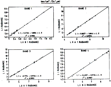
Figure 1 Spetral Radiance Curves
Conclusion
The comparative evaluation of the radiometric behaviour carried out for LISS-I and LISS-II data for selected land cover features showed that comparability exists between the sensors. Linear curve fitting and the correlation coefficient values obtained for each of the bands of the two sensors suggest that the spectral radiance recorded at the sensor are in agreement. The study has also revealed that both the LISS-I and LISS-II sensors are perfectly are working perfectly in terms of spectral radiance behaviour.
Acknowledgements
Authors are grateful to Mr MG Chandrasekhar, Director, EOS and Mr. K Rashakrishnan, Director, NNRSM-RRSSC, Mr. Adiga, Head, RRSSC, Bangalore for their encouragement in carrying out the work. Acknowledgements are due to Mr. AV Sriram and Ms. S Vanaja for secretarial assistance and Ms. M Sameena for cartographic assistance.
References
- Charles J Robino, 1982. Computation with physical values from Landsat data, photogrammetric Engineering and Remote Sensing, Vol. 48 No. 5, pp 781-784.
- Daniel L. Cinco, 1989, Topographic Normalization of Landsat thematic Mapper Digital Imagery Photogrammetric Engineering and Remote Sensing. Vol. 55, No. 9, pp 1303-1309.
- Pat S Chavez, 1989. Radiometric calibration of Landsat Thematic Mapper Mulitspectral Images Photogrammetric Engineering and Remote Sensing, Vol. 55, No. 9, pp 1285-1294.