| GISdevelopment.net ---> AARS ---> ACRS 1991 ---> Mapping from Space |
South East Asia one kilometer
Mosaic from NOAA AVHRR Data
Udai C. Pradhan, Michael
Sheinkman
Suehiro Otoma and Gary E. Johnson
Global Resource Information Database
(GRID) - Bangkok
Suehiro Otoma and Gary E. Johnson
Global Resource Information Database
(GRID) - Bangkok
Abstract
The Global Resource Information Database (GRID) - Bangkok has the assignment to develop a cloud-free mosaic of South East Asia from data acquired by the Advanced Very High Resolution Radiometer (AVHRR) on the National Oceanic and Atmospheric Administration (NOAA) series of polar orbiting satellites. The mosaic will be composited over time and geo-referenced. Data collection is via the receiving facility of the Thailand meteorological Department in Bangkok. The time frame of available data is November 1990 to May 1991.
The paper presents a method for cloud removal from multitemporal NOAA AVHRR imagery by using the normalized difference vegetation index (NDVI) and channel 4 (the thermal band) for cloud/ non-cloud discrimination. The usual method of using only NDVI clouds over unvegetated surfaces are retained. Over such surfaces, the thermal band, is able to detect clouds, on the premises that the temperature of clouds is lower than that of objects on the surface of the earth. In this technique, the NDVI of clouds is used as a threshold which separates two domains - one domain over which NDVI is effective as a cloud screen, and the other over which channel 4 is effective for cloud/non-cloud discrimination. Cloud discrimination and removal is done by comparing the NDVI of the input images to the threshold value, and retaining the pixel with either the higher NDVI or lower channel 4 value depending upon whether the NDVI is over or under the threshold NDVI value.
Introduction
Issues of global climate change, tropical deforestation and sustainable development dominate the concerns of environmentalists and lay people worldwide in this last decade of the twentieth century. The effective management of natural resources for their conservation and sustainable development is, in fact, dependent upon information suitable to the task. Further, environmental require an understanding of the inter-relationships of a number of physical and cultural variables. There is increasing recognition that the related technological developments of Remote Sensing and geographic information systems (GIS) have a variable role to play in the effective management of natural resources for conservation and sustainable development.
In recognition of the capabilities of Remote Sensing and GIS, the united Nations Environment Programme (UNEP) establishment the Global Resource Information Database (GRID) in 1985. in that year, GRID nodes were established in Nairobi, Kenya at UNEP headquarters and in Geneva, Switzerland. In 1989, a GRID node was established in Bangkok, Thailand in conjunction with UNEP's Regional Office for Asia and the Pacific and located at the Asian Institute of Technology (AIT). In 1990, the GRID-Bangkok facility was designated an external program of UNEP.
The mission of GRID - Bangkok, as is the mission of GRID as a whole, is "to provide timely and reliable geo-referenced information and access to a unique international GIS service for addressing environmental issues at global, regional and national levels, in order to bridge the gap between scientific understanding of earth processes and sound management of the environment.
The NOAA AVHRR Project
At the time that GRID-Bangkok was declared an external program of UNEP, a memorandum of understanding was written between UNEP and AIT which established administrative arrangements for the operation of GRID-Bangkok and set out a project agenda for the facility. One of these projects is NOAA one kilometer mosaic of South East Asia. The purpose of this project is to develop a cloud free, composited and geo-referenced dataset using one kilometer AVHRR data from the NOAA satellite series for the region covered by the Bangkok, Thailand receiving station. The data set is to be bound by the time frame of 1 October 1990 to 1 April 1991 and the outer boundaries of the data set are to be limited by the line of correctable distortion (figure 1. The Final product will consist of a 4- channel data set recorded on both 6250 bp magnetic tape and on optical discs.
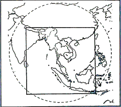
Figure 1 Approximate Satellite Coverage Circle & Study Area
The dataset will be distributed through the GRID network for use in both the Tropical Forest Assessment Program and the International Geosphere - Biosphere Program's (IGBP) Global Land Cover Project.
GRID- Bangkok is to process a designated portion of this dataset to a forest/non-forest classification and verify it by high resolution satellite sampling and / or by ground truth methods. Progress reports will be submitted to UNEP and to the advisory committee on a quarterly basis and a final report will be submitted with the release of the dataset (UNEP -AIT MOU, 1991).
The date, 109 level 1b NOAA 11 AVHRR datasets have been acquired from Thailand Meteorological Department Spanning of dates of 12 November 1990 through 16 May 1991. The remainder of this paper addresses the issues pertinent to the completion of the project.
Methodology
The methodology used in this study may be grouped into three major procedures - data acquisition, pre-processing and compositing.
Data Acquisition
High solution picture transmission (HRPT) level 1b data from the afternoon pass of the NOAA-11 satellite was recorded at the Thailand Meteorological Department receiving station on a daily basis. The data consists of 10- bit reflectances in five channels in a packed band - interleaved - by - pixel (BIP) format, preceded by scan timing, location, calibration and other data. The data was recorded on 9 - track 6250 bpi magnetic tapes.
However, location data as obtained from the receiving station proved to be of less than satisfactory accuracy, probably because the satellite ephemeris data, issued daily by NOAA, was not entered into the tracking/receiving station computer on a daily basis.
Pre-processing
Pre-processing is necessary in order to :
- Generate accurate location data
- Split the 10-bit BIP image into separate 8-bit band sequential (BSQ) images.
- Identify and delete bad / noisy lines.
- Geo reference the image to latitude / longitude co-ordinates using the updated location data.
- Geo-reference the image too an accuracy of within one pixel using ground control point (GCPs) and a first order transformation.
The AVHRR Earth Location Data Set (AELDS) navigation software is used to generate the location coordinates of 51 pixels in each scan line. The AELDS software, in use at GRID- Bangkok, consists of three packages of FORTRAN programs integrated and modified to run on the IBM 3083 mainframe computer at AIT. The FORTRAN source code was obtained form NOAA-NESDIS.
The AELDS navigation software requires three type of inputs :
- The satellite ephemeris data, which is contained in the TBUS message received daily by the Thailand Meteorological Department.
- A timing mark from the clock onboard the satellite, which is broadcast at the beginning of each AVHRR scan line.
- The TIROS Information Processor (TIP) clock correction factor, which is contained in the text at the end of the TBUS message.
Image Unpacking and Format Conversion
The data received from the receiving station is read on the IBM 3082 mainframe computer at AIT and transferred to an IBM PS/2 - 80 machine at GRID-Bangkok, via the IBM PC 3270 emulation interface, along with the new location data generated in the previous step.
The raw data is then processed by an in-house program to extract channels 1, 2, 3 and 4 in a BSQ format, and to convert the original 10-bit data into 8 - bit values by dropping the two least significant bits of the original data.
Noise Removal
This procedure consists of displaying each band of an image in 256 grey levels, and visually inspecting for bad/noisy lines. The different channels of the same image do not necessarily have band lines at the same location, and therefore all four channels have to be individually inspected for such lines. Such lines were marked as being areas of "no data" not only in the channel where it is present, but also at that location in all the other channels, by being assigned zero values.
Geo-referencing using Location Data
Of the 2048 pixels in each scan line, only the central 1024 pixels were used in this study, as the geometric and radiometric distortions towards the ends of the scan line are very large. This first geo-referencing in procedure uses the location data generated previously.
The resolution of the raster image was established at one hundredths of a degree, which translates to roughly 1.1 km at the equator, and is roughly the resolution of the AVHRR sensor at its nadir. The image obtained for a single day covers only a part of the total project area, and the geo-referenced image will also have "holes" in it, partly due to the fact that off-nadir points have a resolution coarser than the 1.1 km resolution at nadir, and partly because the grid resolution becomes finer as one moves ways from the equator towards the poles.
The result of the first geo-referencing procedure is a fairly well registered image with slight shifts in both X and Y directions, the positional error being up to four pixels.
Final Co-referencing
For more precise positioning, the well known method of rectification using ground control points is used.
Coastlines, islands, lakes and confluences of large rivers were chosen as ground control points, the geographical co-ordinates of which were obtained from the vector World Boundary Database II coverage of the world. A normalized difference vegetation index (NDVI) band is created, by using the semi-geo referenced image obtained from previous step, for identifying ground control points, since such a band appears to provide the most detail, especially discrimination between land and water.
At least ten ground control points, chosen to be as uniformly distributed as possible, were selected. The root mean square (RMS) error of GCPs is kept under 1.0, ie, the mean positional error is within 1 pixel. A first order rectification is carried out using a set of in-house programs, implementing a nearest-neighbor resampling in order that new pixel values not be generated.
The resulting rectified image is checked by displaying the rectified NDVI band and then overlaying the World Boundary Data Base II boundaries over it.
Compositing
The compositing process has a two-fold purpose - first, to mosaic the images from different days in order to cover the project areas, and second, to eliminate clouds.
The Compositing Algorithms
The simplest composting algorithms for NOAAS AVHRR data uses NDVI values as a cloud discriminator. Following the convention used in the NOAA Global Vegetation Index (GVI), the NDVI is calculated using the following formula, which results in floating point values:
NDVI = (Band 2 - Band 1) / (Band 2 + Band 1)
This is converted into integer values using the relationship:
SNDVI = 240 - 350 * (NDVI + 0.5)
The simplest cloud-screening algorithm compares the NDVI values of each pixel of the two images being composite, and then selects and retains the pixel which has the higher NDVI value.
This algorithm is very effective over vegetated areas, but it is unable to screen out clouds over unvegetated surfaces like water or bare land. This occurs because bare soil and water exhibit lower NDVI values than opaque cloud (figure 2).
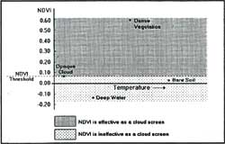
Figure 2 NDVI - Temperature Scattergram for Various Surfaces
Figure 2 shows that the cloud NDVI value serves as a threshold value separating two domains - one in which NDVI is effective, and the other where it is not. It is also observed that bare soil water both exhibit higher temperatures than cloud. Therefore, it is possible to use temperature as the cloud/non-cloud discriminator in both domains, but the resulting composite would not retain NDVI maxima. In order to remove clouds while retaining maximum NDVI, a combined approach is called for in which NDVI is used as the cloud discriminator in each domain where it is effective, but sign temperature in the domain where NDVI is not effective.
Channel 4 of the NOAA AHRR sensor lies in the 10.5 to 11.5 micrometer band width, and is most sensitive to objects in the temperature range of - 50° to +50° Celsius. It is, therefore possible to us channel 4 reflectances as a measure of temperature.
The compositing algorithm as implemented may be stated as follows:
- Set an NDVI threshold value.
- If a pixel NDVI value is grater than the threshold value, retain the pixel having higher NDVI.
- If a pixel NDVI value is less than the threshold, retain the warmer pixel.
Conclusion
The two conclusions resulting from this study to date pertain to the geo-referencing and compositing procedures.
This study show that it is not possible to obtain a geo-referencing accuracy of 1 pixel by using only the location data provided with the AVHRR imagery. A second geometric correction using GCPs with a first order transformation is necessary to provide the required accuracy. Alternatively, it would also be possible to ignore the location data and implement ad third order transformation using GCPs only, but the process of identifying an adequate number of control points proved to be too tedious and time - consuming. It must be noted that only the middle 1024 pixels should be used in either method, if locational errors are to be kept within 1 pixel.
Results form the compositing algorithm are promising. An NDVI threshold of 0.035 is seen to give satisfactory results. The compositing algorithm is superior to the usual method of using NDVI only in that it is able to remove cloud over unvegetated surfaces like bare land and water, while retaining vegetated areas. Though it is possible to use different NDVI thresholds with different images being composites, it is suggested that a single threshold value be used for the entire compositing process.