| GISdevelopment.net ---> AARS ---> ACRS 1991 ---> Mapping from Space |
Accuracies and advantages of
Mapping from Space
S.
Raghunathan
National Remote Sensing Agency
Department of Space
Hyderabad - 500 037 India
National Remote Sensing Agency
Department of Space
Hyderabad - 500 037 India
Abstract
Satellite Remote Sensing data is influencing Map compilation and updation in a significant manner. Thematic details, position and distance information are directly derivable from space Remote Sensing data. Derivation of height contours from satellite stereo data has been demonstrated. An analysis of current satellite performance specifications for these purposes is presented. Also, a practical, convenient exercise carried out for combining product can be registered precisely with map without GCPs, thus avoiding major computation time of rotation and resampling. Although, a methodology is demonstrated through this exercise many more practical problems need to be solved to achieve operational efficiency.
Introduction
Mapping of the earth's surface has been carried out for several centuries. Surveying techniques have been significantly improved with the availability of Remote Sensing (R.S) technology. Aerial and satellite platforms enable us to cover large areas and speed up the process of compilation of maps. Data in different spatial resolutions and spectral bands and well proven visual interpretation/computer processing techniques make it possible to generate thematic maps of given area. Knowledge of satellite position and attitude make it possible to locate features on ground with a fair degree of accuracy (better than a km) without use of any control points. Thus usable maps with thematic details with positional information can be prepared with data obtained from R.S. satellites in a reliable manner.
Conventional Mapping Techniques
Detailed field surveys requiring large manpower and extended time periods have been a major limiting factor in the preparation of maps during the past. Certain amount of human subjectivity is part and parcel of the system. With the availability of aerial photos, need for physical survey of all areas has been eliminated. However, aerial photographic surveys and the subsequent photograpmmetry work required for generation of maps is still a time consuming process. Depending upon the scale of maps required, and the area to be covered, the lead time would be anywhere between one to two years to several years. The thematic information required to be represented in the map thus becomes fairly outdated by the time the map is printed, especially so in the case of dynamic themes.
It may be noted that though maps are prepared from very large scales (1:1000) to very small scales (1: few mission) for various applications and end use, only a standard set of scales of maps are prepared, updated and published /republished in a routine manner. Generally, maps in the scale of 1:250,000 to 1:1 million fall in this class. These scales and map contents depend on the country, its size, history and growth of surveying in the [past, and the development plans cum associated needs for maps. With its ability to cover large areas in a rapid manner, satellite R.S. provides a reliable and quick tool, from preparation of maps in small scales, to updation of maps in large.
Advantages of Satellite Remote Sensing
Collecting data from space multispectral scanners has several advantages and can be grouped into two areas: Spacecraft or platform related, and sensor related. Once launched into a when compared to aircraft and thus the area covered on earth by the sensor onboard can be precisely determined. Satellite orbit altitudes of 700-1000 kms help cover very large swaths and repetitive and sun synchronous nature of orbit assures data over the same area many times under fairly similar illumination conditions throughout its life. A very major factor is that the spacecraft can be used for observing nearly the entire globe if so designed initially as a mission requirement.
The sensors onboard the platform offer us the advantage of high resolution through the Instantaneous field of view, thus enabling us resolve tiny features on the surface of the earth. Multispectral data helps us identify various themes and the repetitive data over a period of time enables us detect the changes since the last observation.
Characteristics of R. S. Satellites
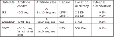
Remote Sensing Data from IRS, Landsat and SPOT are considered for the purpose of this discussion. All the three satellites are three axes stabilized platforms. IRS and SPOT have comparable specifications in terms of attitude control and attitude rates specifications while Landsat is about three orders of magnitude better in terms of attitude drift specifications. For generating the data of products, an estimate of the satellite position, and in turn the image coordinates is computed using pre-facto and post-facto orbital parameters and attitude / drift values. Due to practical limitations of orbit prediction / computation mythologies, a which gross error of the order of several hundred meters is observed which is primarily in the along track direction. This also affects the absolute location accuracy.
More popular and well understood characteristics of the R.S. Satellites are : Sun Synchronous, polarordibiting, repetitive coverage pattern, equatorial crossing time etc., The fact that they are three axes stabilized and the attitude is very precisely controlled, is something that has been little recognized by the users of the data. Here again the attitude rates is much more crucial than the attitude per say, in a relative sense. The methodology determine the location accuracy of the image data. The attitude data, on the other hand, contributes to the internal distortion (or scale accuracy) of the product to a major extent and to the location accuracy in a secondary manner. This is assuming that the attitude rates are of low frequency in nature and their values are 2-3 orders less than the attitude range.
The performance specifications of the currently operational R.S. Space craft and the accuracies of standard data products generated from them are given below :
Geocoded Data
In addition to the standard products, geocoded products are also gaining popularity in the recent past. There is no universal definition for the term geocoded products. In a simplistic sense, it is a map compatible product. The pixel size in a geocoded products is chosen (with over sampling) so that data from different sensors can be over - laid conveniently. For example, IRS LISS-II is 25m, TM 25m, SPOT XS is 12.5 m, and PAN, 6.25 m. The area coverage and scale depend on each country's map standards. In the case of India, IRS geocoded data corresponds to a 50,000 scale map sheet (15' x 15').
The geocoded data can be produced without use of ground control points and the location accuracy / internal distortion specifications are same as that for standard products. But the major advantage is that data covering adjacent map sheet areas can be mosaiced much more conveniently. They can also be overlaid with map data in a convenient manner. The location error which is generally pre-dominant in along track direction can be minimized by simple operational procedures at the ground station preprocessing facilities. This can be done by identifying one or more GCPs in the pass and then shifting suitability the entire frame/pass by appropriate techniques suitable to data product generation software. After this stage, any improvement in the geometric accuracy has to be done only with identification of GCPs.
The improvement is carried out by identifying several GCPs distributed over the image area, refine the attitude parameters through them and recomputed the location of pixels in the imagery. The process is a complex one and is subjected to many practical aspects. Identification of GCPs and correlation of them with stored image chips are limited by several factors which influence the radiometric properties of the features. Besides, computation time is also very high. It has been verified that one is limited by the input/methodology error budget of the order of about 20 to 30 meters - and such GCP based processing does not improve the scale accuracy of the product noticeably. Rather, it is not possible to easily evaluate the improvements if any, due to this processing. The scale accuracy of 0.1% achieved in standard corrected products is comparable to what is generally available in Maps of comparable scales.
As can be seen from the discussions so far, one can get the locations (with a fair degree of accuracy), the distance between any two identifiable objects, and the thematic details over the area of coverage from satellite Remote Sensing data. One important aspect of topomaps is the slope or height contours. This parameter also has been extracted from the SPOT stereo pair data. It has been reported that height variations of a few meters have been derived from such data. All these informations are available in a time scale much shorter than the conventional techniques. For example, satellite R.S. data is available within 3 - 4 weeks of acquisition and the subsequent steps of thematic interpretation, height extraction (Where feasible) etc., will take another few weeks. Thus, in a time frame of about 4 - 6 months from the time of data collection, maps could be prepared/updated in appropriate scales, with a well established, streamlined system.
Integration of Satellite and Map Data :
Use of (Geographical Information System) is on the increase wherein the R.S. data is spatially combined with other information already available in the form of features in topomaps and statistical informations. The main feature required for this is the easy overlaying capabilities of data from several sources. The internal distortion or the scale accuracy of the R.S. data palsy major role for this purpose. This requirement is met verywell byteh standard data products which do not use Ground Control Points (GCPs). The process of precision correction of data involved tedious, subjective and time consuming efforts at the cost of significant computational time.
The are covered by geocoded product, about 32 km X 32 km, is slightly lager than a survey of India toposheets in 1:50,000 scale. Since the bulk of the location inaccuracy is along the orbit direction, it should be possible to register the already north oriented satellite data on a toposheet with linear shifts along pixels and line (Eastings and northings) directions.
In the present exercise all the important features on a survey of India map sheet - like roads, railway lines, heights contours and lad/long grids - were digitized manually using ARC-INFO package. This was converted into rater form and X, Y offset of R.S. data was estimated. The image data was then shifted and verified for registration over the map data. Supervised classification of the Remote Sensing data was done by training sets of land features. The classified data was smoothened using the technique of post classification filtering to optimize the number of polygons and polygonising time. The poligonised thematic map features and was plotted on a vector plotter using the ARC plot. Suitable annotations, symbols and titles were added at the stage.
This exercise was to demonstrate a convenient operational procedures to integrate satellite R.S data with map data. The actual GIS operation for a specified problem will have to be carried out once the thematic data overlaid on map data is available. The main advantages are the registration is done with ease (without resampling) and rapidness, data is available digitally and can be exploited either in raster or vector form to suit the hardware configuration at the user's facility.
A top level flow diagram of the operations carried out is given below:
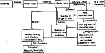
Several practical problems have been experienced in carrying out the above work. Total computer time is still the major issue avoiding precision using ground control points is a significant step towards reduction of time. Besides, the several associated advantages of having data in digital form are available for storing retrieval, plotting etc.,
Conclusions
- Achieved scale accuracy (or internal distortions) of all existing R.S. Satellite data is very good.
- Improvement in location accuracy of data products can be realized by simple operational procedures with a few control points.
- Such standard data products from the existing R.S. Satellites offer several advantages for thematic and planimetric mapping of large areas in a convenient manner.
- These data can be used for preparation of small scale maps and updation of large scale maps, and in a reduced time frame and compared to conventional mapping techniques.
- With improved accuracy and very good scale accuracy, most of the requirements of thematic applications using GIS can be met by geocoded products with standard correction (without precision processing).
- Overview of Cartographic Application of SPOT Imagery
- - PHILLIPE MUNIER, SPOT IMAGE (JUNE, 90)
- Cartographic Production form SPOT data at the 1:50,000 scale
- -IGN FRANCE INTERNATIONAL
- SPOT-1 spacecraft in orbit performance
- -S. RAGHUNATHAN, M.L. MITTAL, NRSA (1989)
- GCPs-Role, Need and Methodology of useage in Remote Sensing
satellite data products.
- -S. RAGHUNATHA,M.L. MITTAL, NRSA (1989)
- IRS-1A Data Quality Evaluation reports from NRSA
- Merging of IRS Geocoded data with map data
- -INTERFACE July-September, 1991
NRSA Publication