| GISdevelopment.net ---> AARS ---> ACRS 1991 ---> Land Use |
A systematic approach for
monitoring Urban Sprawls, their environments using Space Borne images - A
case study
H.S. Mehta &
R.S.Sidhu
Remote Sensing Cell, Civil Engineering Department
S.G.S.I.T. & Sc. Indore (M.P.) India
Remote Sensing Cell, Civil Engineering Department
S.G.S.I.T. & Sc. Indore (M.P.) India
Abstract
The continuous change in the structure of cities is of utmost concern for urban planners and decision makers. Physical planners need information or data for development and planning. Such development plants to be really meaningful and effective are to be based on information and other physical data derived from the maps which are upto-data. The increase in population and automobiles inevitably cause great changes in the urban enters. The problem of expansion of city centers is complicated by the fact that it must take place within the built up area, which is not possible. The rapid increase of population in urban areas and transformation of urban economy leads to an ever increasing demand on the urban environment, in terms of urban capture in the fringe areas. This type of unprecedented growth and development on the periphery of urban areas snowballs into a liability, when they become a part of city. Thus, the pressure of continuously growing city centres, changes the structure of neighboring areas. It is expected that by the years 2001 INDIA will loose about 10 Million Hectares of prime agriculturable land in the form of urban sprawls. As the limited natural resources in the cities and the surroundings gets used up due to unprecedented and unchecked population explosion, the pressure mounts on bringing into force the economics of scarcity. This results in a spirally outward development form the densely populated city centres, to the sub-urban areas and, hence, the agricultural land gets converted into urban use. In INDIA, the problem of such rapid urbanization is more complex because of spontaneous settlements, on account of huge immigration of rural population to the cities in search of jobs and livelihood. This phenomenon of outflux of population from city centres to periphery is termed as URBAN SPRAWL. This phenomenon is consuming agricultural land at such a faster rate that physical planners find it difficult to keep pace with their old, time consuming, costly and inaccurate conventional techniques. Here the authors have kept the pace by the extensive use of remotely sensed, data in its various forms of timely monitoring the urban sprawls, rate of conversion of agricultural land and their environments. The brief study carried for INDORE city shows that in the last two to three decades the study area has expanded alarmingly at the cost of agriculturable land. The remotely sensed data was also used for the environmental monitoring and development in the urban and sub-urban areas. The provision and development of healthy environment has become a burning and challenging problem for the planners and the decision makers. This research work has come up with the brief suggestions for limiting and restricting the growth of urban centres and checking the large influx of population as it is the direct cause of urban sprawls, speculative holdings and spontaneous settlements. Statistical analysis has been carried out, for forecasting of extent and size of urban centres, their environment and population influx for the next two decades. A model has been proposed for the healthy and decentralized urban centres.
Introduction:
Land is in continuous state of transformation. In India, the pressure on land is increasing exponentially not only because of need to provide food fibre and fuel for the ever increasing population, but also owing to the demands from rapid industrialization, urbanization, communication and recreation. Due to this the precious agricultural land and forest cover gets degraded by the preventable causes like water logging, salinity, erosion etc. in the recent years, the nationwide phenomenon of conservation of forests has come into light. The green cover of the land is being destroyed at an alarming rate and the living environment of the urban areas in deteriorating along with the development and expansion of cities. The problem involved in the sustained supply of natural resources for the futuristic demands of mankind has made the planes conscious for the planned utilization of limited natural resources. This requires a detailed understanding of resources available with respect to their quality, quantity and distribution, so as to strike a balance between the exploitation and regeneration process, which ensures the health by environment. Along with the rapid advancement of urbanization and deterioration of living environments in India, there has arisen strong voices to seek comfortable and well off living standards in the urban environments. Under such circumstances, it is considered urgent to conserve and produce better environments by enhancing the recognition of forests in the vicinities of urban and sub-urban areas. In proceeding with maintenance and conservation of environments it is necessary to study the areas from a uniform standpoint with consistent accuracy, which helps in continuous and time sequential monitoring. Simultaneously, the development of artificial forests, gardens, parks and orchards etc. in the urban areas is also very effective in the preservation and enhancement of environments.
Ribbon development of urban sprawls:
The degradation of agricultural land is not only confined around the cities, but it is upcoming very fast on and around the city or state highways. Dewas is a district headquarter and is famous for its big Industrial Setup, situated about 36 Km from Indore city on NH-3 in the North-Eastern direction. Mhow another district headquarter is also situated 21 Kms from Indore on NH-3 in South-West direction. Indore being the centre of these two districts receives maximum influx of population, which migrates in search of better living standards and good civic facilities. This continuous influx acts as a catalyst in the expansion of urban city limits which is afterwards termed as urban sprawl. Similarly, there are many small towns and villages which are impounding great amount of pressure on Indore city and bringing into force the economics of scarcity. With such situations in the background this study was carried out to examine the functional analysis of forests and their development in the appropriate places by the extensive use of Remotely Sensed data.
Study Area:
The study area covers the very prominent district of the central province (M.P.) of India. The INDORE DISTRICT with following Geographical co-ordinates. Longitude 750-46' to 750-57'E and latitude 220-37' to 220-50'N. Indore is also called as the commercial capital of Madhya Pradesh (Central Province) because it is a prominent business centre and at present it is spread on about 19325 ha of land. Two to three decades back it was spread only on 2482 h. similarly, the population of Indore City has increased about 28% in the last two to three decades. The total influx form the villages of Indore district is about 2.2% and from other cities is about 1.2%. Influx from other district is about 9.6% and other villages of districts is about 20.2%. The overall influx is about 42-43% per decade. During the normal course of development and expansion of urban settlements, rural areas continues to merge with the urban areas.
Data Sets Used:
To complete the above research authors have used Multidate Remotely Sensed data in the form of-
- Colured Transparencies (SPOT.1 HRV 1 MLA Band 1,2,3, Feb 90) 23 x 23 cms - Further enlarged using PROCOM-2
- F.C.C. of TM and IRS-IA LISS II.
- Survey of India Topographic Maps.
- Survey reports published by Development Authorities.
- Master Plans etc.
Methodology revolves around the visual interpretation techniques of Remotely Sensed data, as described in the following steps:
Step 1:
- Preparation of base maps from Survey of India toposheets of the study area.
- Upgrading of the base maps by overlaying them on various (recent) satellite images.
- Mapping from satellite images by visual interpretation of past years.
- Comparison and change detection by mapping from recent images.
- Comparison with predicted reports by development authorities.
- Statistical Analysis of the compared data.
- Plan and prediction for the next two decades.
- Based on conclusions and analysis, suggestion for the enhancement of urban environment.
The two involves the through field works as well as Lab work.
- Detection of intercity spaces for development Gardens/Orchards/Green space.
- Site selection for plantation of trees in towns, colonies etc.
- Selection of land (non-agriculturable) for the development of buffer zones around the cities for the restriction of their growth.
- Selection of sites for development of interlinked satellite villages/towns so as to stop the influx of population to the urban centres.
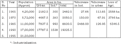
As the study area is surrounded by the big industrial areas, it has a greater impact of urbanization, concretion, population influx, industrialization, loss of agricultural land, increase in traffic density etc. has caused serious environmental problems to the in habiting population. Otherwise also Indore is called as the commercial capital of State and is the most urbanized district. It is bounded by Ujjain in the North, Dewas in the East and Dhar (Pithampur) in the West. Being the central part of the above named industrial sector, the study area receives heavy influx of population. The commercial centre, Indore, was spread over an areas of about 2,482.5 ha., out of which 2,182.5 ha. was under residential units and 300 ha. under industrial units in 1965. (Ref IDA Report 1965). But in the last two to three decades the study area expanded to the extent of 19,325.5 ha. out of which 17,787.5 ha. lies under residential and 1,538 ha. under industrial units. The spontaneous increase in urbanization, concretion, loss of agriculture land and increase in population is given in the Table - 1 Plate I.
The graph plotted for the population against the time shows that the population of Indore city is going to rise by 21-22 lacs by the year 1995.
Dewas, the district headquarter of the Distt. Dewas in the North of the study area on the NH-3 was a usual town spreading over an area of about 852.5 ha. in the early 60's. The industrial area was only about 277.5 ha., whereas the residential area was about 575 ha. In the era development from 1970 to 1985, in the span of 15 years, Dewas expanded exponentially, and heavy industrialization took place owing to the subsidy provided by the State Gov. under the rural area of upliftment scheme. As a result of this by the year 1990-91, this area developed into a prominent industrial state, spreading over an area of about 3,357.5 ha. With the rapid industrialization and urbanization the population of Dewas city increased by 116% per decade. And in the last two decades about 2,505 ha. of fertile agricultural land was lost Similarly, in the mid 60's to early 70's, Pithampur, Sagore and Bagdun were the well known villages in the Dhar district with a population varying from 1500 to 2000. In the mid 70's the Govt. of M.P. plan to develop industrial estate for the automobile industries, in a view to create a DETROIT IN INDIA. For this, Govt. provided the subsidy to the industrialist coming forward.
Further, in the span of 15 years, i.e. in mid 80's Pithampur industrial estate partly developed and spread over an area of about 2,530 ha. In the last 5 years i.e. from 1985 to 1991, Pithampur has shown rapid development of industrialization and is finally spread over an area of 52,825 ha. This increase in industrialization and its impact is directly born by the fertile agricultural land which got converted. Likewise the other district Ujjain has also grown exerting the pressure on the study area. The degradation of agricultural land is not only confined around the cities but it is rapidly consuming the land on either side of the National as well as the State Highways giving rise to urban sprawl. During the normal course of development of urban settlements, the rural settlements continued to merged with them. Likewise there were 27 villages in the vicinity of study area and all of them merged and are now under the municipal limits. With an area of about 158.20 sq. kms. Out of which 140 sq. km. was the fertile agriculture land. With this the total study area covers about 214 sq. kms. Which is totally accountable as urban sprawl.
Impact on environment:
This rapid urbanization has exerted a great pressure on the ecology and the living environments as well as on the natural ecosystems of the study area. The increased interference in the natural ecosystems has caused undue, unnatural calamities and hazards to the human life. Specially in the study area the fact of environment development has been neglected just to keep the personal gains at first preference. If the "Phenomena of development without destruction" is followed during the development of the healthy environment along with the urbanization, the environmental and its related problems can be solved to a great extent. Major factors contributing in the deterioration of the environment are as follows:
(1) Increase in population. Biggest problem is the ever increasing population of the country, state or an area. Due to this population explosion, the limited natural resources get deflated at a faster rat, thus bringing into force the economics of scarcity. To meet the ever increasing demands of food, fibre and fuel of the population, a greater part of the natural resource vanished. As the study area is biggest commercial and business centre the whole state, it receives a large influx of population from the other neighbouring areas, with the intention of better living standards. Thus, congesting the whole place day after day. To meet the regular demands of urban population, a great amount of pressure is exerted on the limited natural resources which erases them from the base itself. The large part of the population living in slums and dwellings gives rise to sanitary problems, which is the direct cause of pollution of healthy surrounding environment. The use of coal, wood and cowdung is the main source of fuel which increases the amount of Carbon-di-oxide, Carbon monoxide and smoke in the atmosphere.
(2) Increase in traffic density: This is also the directly related factor to the population. As the population keeps increasing the traffic density also keeps on increasing, giving rise to hazardous smoke and dust pollution. As the population of the study area is in between 16-18 lacs. The estimated number of vehicles is about ¼ of the total population, i.e. 3-4 lacs. If the total area of the roads is divided by the total number of vehicles, an astonishing result about the traffic density can be found out. This increased density of Carbon-di-oxide and smoke in the atmosphere is becoming the cause of different diseases related to the skin and breathing.
(3) Land transformation: Owing to the heavy urbanization, concretion, industrialization, development etc., the natural cover of the land gets destroyed. Thus, the agricultural land gets transformed into urban settlements giving rise to temperature by corner effect and reflection. Development of residential colonies in the surrounding study area, is engulfing a large part of the agriculturable land. Agriculturable land at large is also encroached by farm houses, dairy farms, poultries etc.
(4) Deforestation: Destruction of natural cover in the vicinities of urban as well as sub-urban areas has caused tremendous problem to the environment. Forests are the main suppliers of oxygen to the atmosphere. They help n many ways in the preservation of healthy environment like, sedimentation of dust from the atmosphere, mitigation of climate, keeping the temperature low, humidifying the climate and thereby creating a scenic surrounding for urban settlements, exactly, adverse and opposite effects hamper the environment, if this precious natural resource is destroyed. The rate of deforestation keeps on increasing than the rate of deforestation. Until and unless a balance is strike in between the two, this problem never be tackled. To overcome this problem a greater number of plants/trees are to be planted in the forest blanks, and in the vicinity of urban and sub-urban areas.
(5) Industrialization/Urbanization: The heavy and unplanned industrialization in the surrounding as well as in the study area has deteriorated the urban environment by various types of industrial pollution, viz. smoke pollution, chemical waste and solid dump. Dust pollution from the open stone quarries in the vicinity of the study area has also caused serious environment hazards to the local population.
Futuristic ideal model for human settlements:
The authors have suggested the implementation of a phenomena of "DEVELOPMENT WITHOUT DESTRUCTION" for the future developments of human settlement. The model shows the proposed environmentally sound human settlement plan. (refer Fig. No.1). The model shows the proposed plan for the development of various factors which acts as the catalyst in enhancing the environment in the particular area.
Conclusions:
The following conclusions have been drawn from this case study:
- The population influx and outflux has to be checked, for striking a balance between population, and its impact on the natural resources.
- Effective management and exploitation of limited non-renewable and renewable natural resources available for the ever increasing population, should be done.
- Forest and water are one of those renewable natural resources, which are being destroyed at a faster rate. Thus their development in and around the human settlements should be carried out to improved and conserve the healthy environment.
- Agriculturable land should not be brought under the future development plans of urbanization.
- During the development of rural areas into industrial areas, their civic environment must be also be equally developed so as to restrict the migration of population.
- The main causes of urban spawl, like, speculative holdings, spontaneous settlements and ribbon development should be restricted.
- As far as possible a restriction should be imposed on the further development of urban areas taking into account the availability of natural resources.
- For the rural population, the agriculture produce has a higher edge over the industrial produce. So the agriculture land should be saved.
- Around the study area, rural villages should be developed into satellite towns in order to restrict outflow of population.
The authors express their deep sense of gratitude to Dr. J.P. Shrivastava, Director and Dr. O.P. Bhatia, Prof. & Head, S.G.S. Institute of Technology & Science, Indore (M.P.) INDIA for providing all the help for carrying out this research work. Authors also express their sincerest thanks to Mr. B. Sakalley, Scientist, Remote Sensing Application Centre, Bhopal (M.P.) INDIA for his expertise at times.
References:
- Anderson, J.R., Hardy E.E., Roach J.T. and Witmer R.E., 1976. A land use and land cover classification system for use with Remote Sensing data. Geol. Survey prof. paper 964,28p.
- Manual of Remote Sensing (1984), Voll.II American Society of Photogrammetry, 210, falls Church, Virginia, USA.
- Personal communication in district and divisional offices, Agriculture, Irrigation and Public health Departments. Indore, Dewas and Dhar districts M.P.
- Report-Indore Development Plan, 1971, Published by Town and Country Planning Department M.P.
- Remote Sensor imagery in urban research, Some potentialities and problems, Eric G. Moore and Barry S. Wellar, Technical letter NSA-118, May 1968, p. 8a.
- Subudhi A.P., Sharma N.D. and Mishra D., "Use of LANDSAT Thematic Mapper for Urban Landuse/Land cover Mapping" (A Case Study of Lucknow and its Environs), published in Photonivachak, Vol. 17, No.3, 1989, journal of ISRS.
- Uttarwar P.S. and Sokhi B.S., 1989. Remote Sensing in Urban fringe study. Photonirachak, 17(3):43.
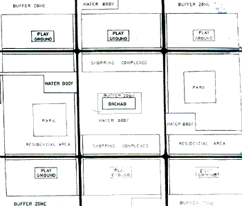
Futuristic ideal model for human settlements
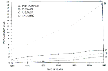
Graph showing population influx