| GISdevelopment.net ---> AARS ---> ACRS 1991 ---> Land Use |
GPS/GIS Combined System
Application Research
Li Shu Kai
The Institute of Remote Sensing Application Chinese Academy of Sciences, Beijing, PO, 100101
Xu Chang
The Institute of Remote Sensing Application
Chinese Academy of Sciences, Bei Jing, PO. 100101
Zhang Zhong
Department of Cartography Institute of Geography,
Academi a Sinica
The Institute of Remote Sensing Application Chinese Academy of Sciences, Beijing, PO, 100101
Xu Chang
The Institute of Remote Sensing Application
Chinese Academy of Sciences, Bei Jing, PO. 100101
Zhang Zhong
Department of Cartography Institute of Geography,
Academi a Sinica
Abstract
In this paper, GPS/GIS combined system is based on GPS, Global Positioning System) to receive and translate Geo-coordinate into GIS ( Geographic Information System ) directly, automatically, it is GIS's revolution from scatter, long cycle, local position to successive, quickly, world-wide, then, it can be used in the global environment monitoring, real-time disaster monitoring. The paper gives GPS/INF, GRASS, AUTO.DXF, etc), automatically, GPS/GIS combined system information real time I/O, and gives specially GPS/ARC-generate combined system and the experimental research of GPS/ARC-generate combined system, It is not difficult to see the advantage of this system.
1.0 Introduction
All of us known, as man rushes to explore and develop his world, the geographic information system is an important tool, maps to forest management, and the global environmental change. With computer storage more large, operating faster, function stronger , GIS are more developed.
Since Canada established the first GIS in 60s in the world to now, now, GIS have been over 20 years developing history. Unfortunately, gathering the data that goes into those database has always been a tedious and require teams of trained personal. Digitizing aerial photographic is faster than surveying, but less accurate, concealing ------------------------------ aera, such as covered by forest, room, could lost much information, and with the features of our world changing so quickly, you can hardly afford to fly a photo miss every time you need a few new points. to the global GIS, natural resources and environment application system that scientist are researching actively also need establish an unite coordinate system. GPS that have all the weather, real-time, the world-wide capability can resolve these questions. Static relative position provides accuracy of 0.1ppm, dynamic had applied GPS higher technology in fire monitoring, forest management ( Gerlach), geographic information system, land information system (By. David), etc.
This paper gives GPS/GIS combined system that may have real-time geo-code, all the weather capitability, and gives a special mode: GPS/Arc-generate combined system, and its experiment.
2.0 GPS/GIS Combined System Mode
2.1 The Global Positioning system
GPS ( Global Positioning System) is a satellite - based , radio-navigation system operated by the U.S. Department of Defence, when full deployed ( scheduled for 1994), GPS will consist of 24 satellites in 12 hour orbits, and the ground support necessary to maintain the system u, GPS will provide users with all-weather, worldwide 24-hour navigation-capability. GPS accuracy is a function of the user's equipment, the user's processing methods, and the full capabilities of GPS. Given these variation , accuracies can range from 1 centimeter to 100 meters. A GPS receiver can be basically provide only two types of measurements code phase and carrier phase, It's easiest to type of processing, and the status of Selective Availability as in the table.1:
| Receiver | Type | Differential Processing | Selective Availability | Approximate Horizontal Horizontal Accuracy |
| Code | Phase | No | Off | 15 meters |
| Code | Phase | No | On | 40 meters |
| Code | Phase | Yes | Off | 2-5 meters |
| Code | Phase | Yes | On | 2-5 meters |
| Carrier | Phase | Yes | Off | 1cm |
| Carrier | Phase | Yes | On | 1cm |
2.2 GPS/GIS combined system mode
GIS is based on computer software and hardware to store, analysis, display and map by natural resources and environment information of aera research on spatial distribution and geographic location, GIS is a synthetically analysis application technical system GPS/GIS combined system mode includes in satellites single acquisition, downloading data, display8ing current position, translating , into any GIS database (including ARC/INF, GRASS sites, GRASS, AUTO. DXF, PC-MOSS, USGS+DLG, etc) automatically and real - time I/O of GPS/GIS combined system information. Fig.1 shows its mode frame map.
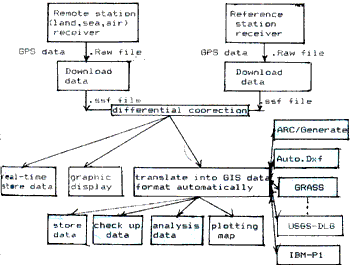
Fig. 1 GPS/GIS Combined System Mode Frame Map
2.3 Datum transformation
GPS data is in WGS 84 ( World Geodetic System ) , its ellipsoidal parameters was given in the 17th IUGG congress, because of differential parameters in each country, or region, GPS data must be transformated by user's aim, including 3 parameters, 5 parameters, 7 parameters transformation mode ( K,x,y,z, £wk, ).
3.0 Experimental research of GPS/ARC - generate Combined System
3.1 Experimental conditions
The GPS pathfinder Basic System used in this experiment is a combination of a GPS pathfinder basic receiver and a suite of computer software, it is a hand-held, battery-powered GPS receiver with three channels capable of tracking up to eight satellites. It supports over 40 datums geodetic or UTM coordinates, land, sea, air modes for the a differential application environments. Positions are computed approximately once per second and be stored for later transfer to a user's IBM compatible personal computer.
3.2 Satellites distribution during experiments
The fist experiment took place on Jun 3, 1991, from 19:37 to 19:40, satellites visible were 2, 6, 13, 14, 15, satellites selection were 2, 6,13,15, PDOP ( Position Dilution of Precision ) was 3.45. The second experiment took place on Jun 12, 1991, from 19:18 to 20:15, satellites selection were 2,12,13, 18, PDOP was 2.65.
3.3 Data processing
The first experiment, there were 100 points received along experimental area's bandary, each position was computed approximately once per second successively, and translate each point into ARC/generate "lines-connect all points" format, automatically. Fig.2 showed a strip map with original data and spline map with ARC/INFO software of 100points. The second experiment, there were 6 stations each stations position was translated into ARC/INF" point - mean point of file" format by received 20 points Fig. 3 showed a polygon map with 6 stations.
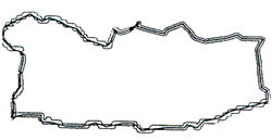
Fig 2. The first experimental map
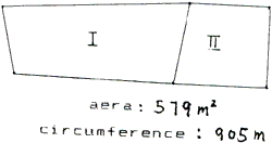
Fig 3. The second experimental map
4.0 Conclusions
4.1. GPS/ARC-geerate combined system in this paper has given the advantage plotting points, quickly, and computing aera, circumference accurately.
4.2 With technology developing, GPS receiver will tend smaller, Cheaper, Operating flexibly, and GIS software micro-computer realizing, GPS/GIS combined system will have extensive application in the global environment monitoring, forecasting crop yield. LIS, etc. therefore GPS/GIS combined system will have more economical and social advantage.
References:
- "GPS Pathfinder Basic Manual" PFBASIC Release 1.00 part number 16848, Revision B December 1990.
- Dr. Leonaed: "Applications of the Global Positioning System to GIS Data Collection" Trimble Navigation